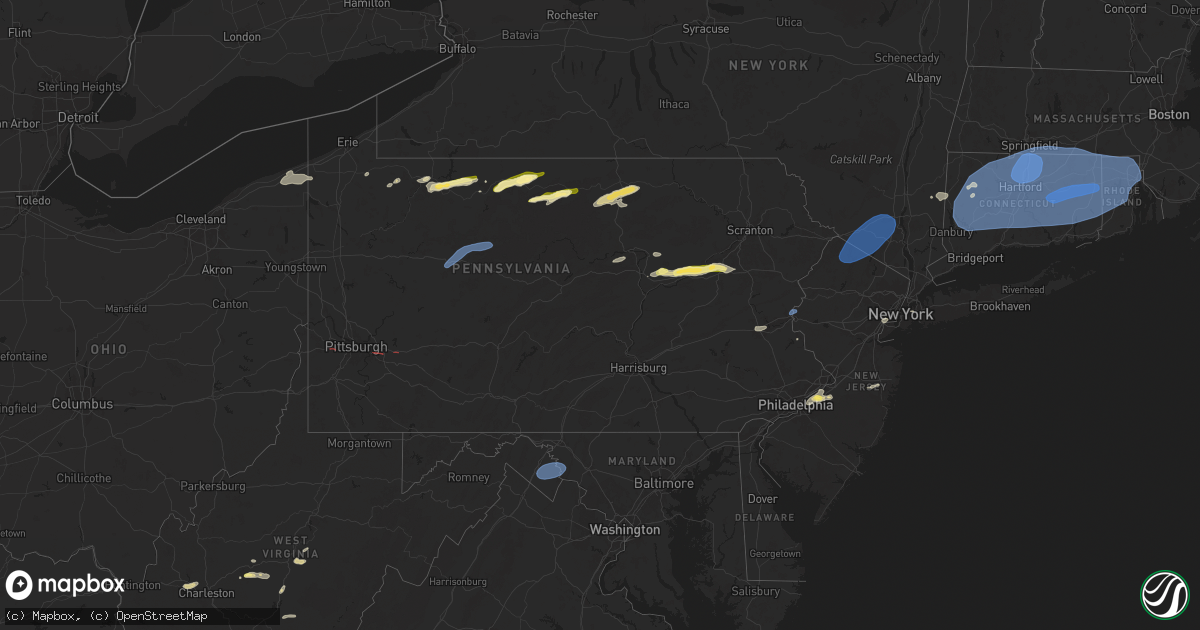
Hail Map in Pennsylvania on June 26, 2024
Get this storm
June 26 map
$229
one time, instant access
Download today. No call, no setup
Keep the $229
Bought the map and want the full workflow? Apply the entire $229 to a subscription within 7 days. None of it is wasted.
Every map, not just this one
This buys you this map. Subscription and you get every map we run, in the markets you choose from a few cities to whole states to nationwide. Plus real-time alerts the moment a storm fires.
Contact data
Name, contact info, occupancy, even credit band for addresses in the footprint. You go from where it hit to who to call.
Become the source they trust
Unlimited branding weather history reports on demand. You already have the documented answer ready for the property owner, and you are the one who showed up with it.
Property data and RoofTrace estimates
Pull up any address you have got, its value and the exact code rules for that jurisdiction, straight from One Click Code. Then RoofTrace estimates the squares, pitch, and roof value, priced the way you price.
Storm reports in Pennsylvania
Pennsylvania
| Date | Description |
|---|---|
| 06/26/20246:59 PM CDT | Large trees and branches down along 4th and 5th streets in the mellon plan neighborhood of monroeville. Siding also removed on a couple of houses along 5th street |
| 06/26/20246:59 PM CDT | Numerous calls of tree damage for north versailles and east mckeesport area. Time estimated by radar. |
| 06/26/20246:57 PM CDT | Report from mping: trees uprooted or snapped; roof blown off. Time estimated by radar. |
| 06/26/20246:50 PM CDT | Limbs down in squirrel hill south |
| 06/26/20246:42 PM CDT | Mping report of wind damage. |
| 06/26/20246:38 PM CDT | Electrical services ripped out of home. Outbuilding damaged by trees on 3rd street. Possible tornado. |
| 06/26/20246:38 PM CDT | Tree uprooted on vincennes avenue. Structural damage to home. Tornado possible. |
| 06/26/20246:35 PM CDT | Tree and wires down on road. |
| 06/26/20246:35 PM CDT | Lots of tree damage along a 1/2 mile path. Likely tornado |
| 06/26/20246:34 PM CDT | This location is near end of track of low end ef1 tornado with winds around 90 mph. The tornado skipped along the path and uprooted or snapped trees along the path star |
| 06/26/20246:32 PM CDT | Possible tornado. Damage and trees down at donaldson park... Donaldson elementary... And north fayette municipal bldg. |
| 06/26/20246:30 PM CDT | Trees down at north branch road and seabright road. |
| 06/26/20246:27 PM CDT | Tree down on wires; on fire. |
| 06/26/20246:25 PM CDT | Tree and wires down next to house. |
| 06/26/20246:24 PM CDT | Tree down on road. |
| 06/26/20246:13 PM CDT | Large tree down on top of a garage and several cars near 8th and wood street. Time estimated. |
| 06/26/20246:11 PM CDT | Power lines and trees down in hellertown. Time estimated. |
| 06/26/20246:10 PM CDT | Trees down acr |
| 06/26/20246:10 PM CDT | Large tree branches down across columbia street in bethlehem. Time estimated. |
| 06/26/20246:10 PM CDT | Trees down across the road on center street in bethlehem. Time estimated. |
| 06/26/20246:10 PM CDT | Trained spotter measures 59 mph wind |
| 06/26/20246:10 PM CDT | Trained spotter measures 59 mph wind gust. |
| 06/26/20246:09 PM CDT | Large tree uprooted and lying across road on n ulster street. Time estimated. |
| 06/26/20246:05 PM CDT | Several large branches snapped off that are 3-4 inches thick. No damage to structures. |
| 06/26/20245:58 PM CDT | Trained spotter relays report of 58.1 mph wind gust on a calibrated vortex inspeed. |
| 06/26/20245:57 PM CDT | Large branches down across road in upper macungie twp. Time estimated. |
| 06/26/20245:54 PM CDT | Wires down with a smoking pole. |
| 06/26/20245:53 PM CDT | Beckers rd - wires down arching and sparking in alsace twp. |
| 06/26/20245:51 PM CDT | Multiple trees down across roads in pocono pines. Time estimated. |
| 06/26/20245:50 PM CDT | Several trees down in the lake harmony area. Time estimated from radar. |
| 06/26/20245:48 PM CDT | Wires down across railroad tracks and on roadway near leesport ave and snyder rd in ontelaunee twp. |
| 06/26/20245:47 PM CDT | Nws storm survey conducted on wind damage in kidder township near lake harmony. Path of snapped and uprooted trees began on chalet court. Along chalet court and lupine |
| 06/26/20245:45 PM CDT | Corrects previous non-tstm wnd dmg report from maiden creek. Large tree uprooted over a driveway. |
| 06/26/20245:43 PM CDT | Tree down near intersection of angora rd and warner rd in lower alsace twp. |
| 06/26/20245:43 PM CDT | Wires down and trees blocking the road. |
| 06/26/20245:40 PM CDT | Tree down on road. |
| 06/26/20245:38 PM CDT | Tree down on road. |
| 06/26/20245:35 PM CDT | Delayed report. Numerous trees |
| 06/26/20245:35 PM CDT | Several trees down from mahoning township to franklin township. Time estimated from radar. |
| 06/26/20245:31 PM CDT | Delayed report. Centre twp: shartlesville rd & trolly rd - tree & wires down. Time estimated. |
| 06/26/20245:30 PM CDT | Tree down on road. |
| 06/26/20245:26 PM CDT | Wires down on irish creek rd in penn twp. |
| 06/26/20245:25 PM CDT | Numerous reports of trees and wires down in rush... Rahn... Walker... And west penn township in eastern schuylkill county. |
| 06/26/20245:22 PM CDT | Tree down on port clinton ave with power lines down. |
| 06/26/20245:20 PM CDT | Tree down on the road. |
| 06/26/20245:20 PM CDT | Trees down on road. |
| 06/26/20245:17 PM CDT | Tree down on road. |
| 06/26/20245:15 PM CDT | A local report indicates 1.00 inch wind near Dorrance |
| 06/26/20245:11 PM CDT | Numerous trees down and barn damage along fowlersville road. |
| 06/26/20245:10 PM CDT | Trees down on road. |
| 06/26/20245:08 PM CDT | Numerous trees and wires down in the pottsville area |
| 06/26/20245:08 PM CDT | Numerous downed trees... Along with building damage... Occurred in roughly a 4 mile path from lightstreet eastward to briar creek township. Inclusive of the damage was |
| 06/26/20245:05 PM CDT | Trees and wires down. |
| 06/26/20245:02 PM CDT | Trees uprooted or snapped; roof blown off. |
| 06/26/20244:55 PM CDT | Multiple trees down along the road. |
| 06/26/20244:55 PM CDT | Multiple trees and wires down along rt 11. |
| 06/26/20244:55 PM CDT | Tree down on structure. Partial collapse. |
| 06/26/20244:53 PM CDT | Multiple trees and wires down. Nj 4064 7460 nj dot - stmc: downed tree on i-78 eastbound west of exit 33 - cr 525/liberty |
| 06/26/20244:53 PM CDT | Multiple trees and wires down. |
| 06/26/20244:50 PM CDT | Tree down on wires. |
| 06/26/20244:50 PM CDT | 1.0 inch |
| 06/26/20244:50 PM CDT | Roof lifted off and dropped back onto gift shop... Causing total destruction of the building. |
| 06/26/20244:50 PM CDT | Update to previous lsr. Nws state college surveyed severe downburst with even higher winds in columbia county... But estimated 60 mph gusts when it reached luzerne incl |
| 06/26/20244:47 PM CDT | Report from mping: 1-inch tree limbs broken; shingles blown off. |
| 06/26/20244:45 PM CDT | 3 inch to 4 inch limbs down with small trees uprooted. |
| 06/26/20244:45 PM CDT | 4 inch to 5 inch limbs down and trees uprooted along rt 72. Some large limbs hanging in the power lines. |
| 06/26/20244:45 PM CDT | Multiple trees down across the roadway blocking one lane of rt 487. |
| 06/26/20244:43 PM CDT | Corrects previous hail report from 2 se stillwater. 1 inch |
| 06/26/20244:40 PM CDT | Tree down blocking ray st north of market st. |
| 06/26/20244:40 PM CDT | Very large tree uprooted and into the side of a house crushing the porch. |
| 06/26/20244:40 PM CDT | Trees down on the roadway. |
| 06/26/20244:39 PM CDT | Trees down both snapped off and uprooted... Large limbs strewn about... |
| 06/26/20244:37 PM CDT | Corrects previous tstm wnd dmg report from selinsgrove. Numerous trees down and roof damage. |
| 06/26/20244:35 PM CDT | Multiple trees down across main st partially blocking rt 209. One tree fell on a parked car. |
| 06/26/20244:34 PM CDT | Numerous trees down and roof damage. |
| 06/26/20244:25 PM CDT | Trees down on the roadway. |
| 06/26/20244:25 PM CDT | Large tree limbs broken; power poles down. |
| 06/26/20244:25 PM CDT | Tree down at restaurant on lower paxton st. |
| 06/26/20244:25 PM CDT | Tree down. |
| 06/26/20244:23 PM CDT | Report from mping: 1-inch tree limbs broken; shingles blown off. |
| 06/26/20244:21 PM CDT | Wires down in kettle creek. |
| 06/26/20244:20 PM CDT | Multiple trees down across the railroad tracks blocking the railway. |
| 06/26/20244:20 PM CDT | 1 inch |
| 06/26/20244:20 PM CDT | Wires down across red hill rd outside of daulphin... Pa. |
| 06/26/20244:20 PM CDT | Trees and wires down across both lanes of rt 11 blocking both lanes... Traffic being rerouted. |
| 06/26/20244:19 PM CDT | Multiple reports of down trees and snapped tree limbs. |
| 06/26/20244:10 PM CDT | Pole and wires down with the transformer on fire. Wires on the roadway. |
| 06/26/20244:05 PM CDT | Multiple trees and wires down in saint marys. |
| 06/26/20244:05 PM CDT | Trees and wires down blocking the roadway. |
| 06/26/20244:03 PM CDT | Trees and wires down in brockport. |
| 06/26/20244:02 PM CDT | Report from mping: 1-inch tree limbs broken; shingles blown off. |
| 06/26/20243:55 PM CDT | Trees on power lines with wires on the road blocking the road - arching and sparking with small fire. |
| 06/26/20243:55 PM CDT | Tree down and several large 5 inch limbs broken off and blocking the roadway. |
| 06/26/20243:55 PM CDT | Report from mping: 1-inch tree limbs broken; shingles blown off. |
| 06/26/20243:51 PM CDT | Trees and wires blocking roadway... Pole snapped. |
| 06/26/20243:50 PM CDT | Trees and lines down with tree on house on main street in brockway. |
| 06/26/20243:47 PM CDT | Trees and lines down with tree on house on main street in brockway. |
| 06/26/20243:46 PM CDT | Asos station kduj dubois airport gust 57 knots. |
| 06/26/20243:43 PM CDT | Corrects previous tstm wnd dmg report from 1 wsw kistler. Wires down and trees blocking the road. |
| 06/26/20243:43 PM CDT | Multiple reports of trees down in morris. |
| 06/26/20243:40 PM CDT | Trees snapped and uprooted. Power was out for 14 hours. |
| 06/26/20243:40 PM CDT | Trees blocking i-80 exit 86 on-ramp. |
| 06/26/20243:36 PM CDT | Trees down on waterfall lane. |
| 06/26/20243:24 PM CDT | Mping report of wind damage. |
| 06/26/20243:10 PM CDT | Downed tree in wires on us 6 both directions between short st and philips st. All lanes closed. Location intersection of short st in mount jewett [boro] - intersection |
| 06/26/20242:32 PM CDT | Corrects previous non-tstm wnd dmg report from 4 ne roulette. Tree down across the roadway blocking one lane of traffic at the intersection of raven hill rd and fishing |
| 06/26/20242:30 PM CDT | Tree down blocking the roadway - halsey rd near the intersection with rt 219. |
| 06/26/20242:22 PM CDT | Tree down blocking the roadway at the intersection of looker mountain trail and dallas rd. |
| 06/26/20242:20 PM CDT | Time estimate by radar |
| 06/26/20241:35 PM CDT | Hail reported during heavy rainfall from showers over mount jewett. |
| 06/26/20241:20 PM CDT | Tree down blocking the roadway. |
| 06/26/20241:12 PM CDT | Several reports of trees and wires down around warren and youngsville. Power outage in warren. |
| 06/26/202412:59 PM CDT | Union pd reported a tree fell on a ups delivery truck on concord st near bridge st. |
| 06/26/20248:22 AM CDT | Tree down on mae west road and tub run road. |
| 06/25/20249:46 PM CDT | Pictures from a trained spotter showed some downed trees and wires on baeder road... Rodman avenue and old york road. A downed tree landed onto a house on rodman avenue |
| 06/25/20249:45 PM CDT | Large tree branch down on wires with other large limbs down on paxson ave in glenside. |
| 06/25/20249:39 PM CDT | Tree down on the 4800 block of waggoners gap rd. |
| 06/25/20249:39 PM CDT | Wire down across the roadway on clouser hollow rd. |
| 06/25/20249:00 PM CDT | Multiple reports of trees and wires down in littlestown. |
| 06/25/20248:41 PM CDT | Report from mping: 3-inch tree limbs broken; power poles broken. |
| 06/25/20248:25 PM CDT | Trees down blocking the roadway... Wires down with a fire. |
| 06/25/20248:25 PM CDT | Multiple trees uprooted and/or snapped off with multiple power lines downed. |
| 06/25/20248:22 PM CDT | Tree down on mae west road and tub run road. |
| 06/25/20248:18 PM CDT | Trees down between farmington... Pa and elk park... Pa. |
| 06/25/20248:15 PM CDT | Multiple trees uprooted and down. |
| 06/25/20248:05 PM CDT | Trees uprooted and wires down - caused a small brush fire. |
| 06/25/20247:50 PM CDT | Trees down on the roadway. |
| 06/25/20247:50 PM CDT | Trees and wires down across the roadway. |
| 06/25/20247:44 PM CDT | Tree damage on w 15th street. No structural damage reported. Time estimated by radar. |
| 06/25/20247:42 PM CDT | Delayed report - multiple trees snapped and lawn furniture overturned. |
| 06/25/20247:31 PM CDT | Report from mping: trees uprooted or snapped; roof blown off. Time estimated by radar. |
| 06/25/20247:31 PM CDT | Report from mping: 3-inch tree limbs broken; power poles broken. Time estimated from radar. |
| 06/25/20247:31 PM CDT | Report from mping: 3-inch tree limbs broken; power poles broken. Time estimated by radar. |
| 06/25/20247:31 PM CDT | Possible tornado. Trees down and debris. |
| 06/25/20247:30 PM CDT | Trees down along pizza barn road |
| 06/25/20247:30 PM CDT | Storm survey confirms ef-0 tornado tree damage along a short stretch of newport road nw of blairsville... Pa. Details on the path length and width will come at a later |
| 06/25/20247:27 PM CDT | An ef-0 tornado occurred along dairy farm road. A public information statement will follow. |
| 06/25/20247:26 PM CDT | Damage to trees and trailer coincident with a circulation evident on radar. Possible tornado. |
| 06/25/20247:23 PM CDT | Numerous broken trees. Siding ripped off garage... And debris laying all around. This was in direct path of velocity couplet on doppler radar and just downstream of a t |
| 06/25/20247:22 PM CDT | Roof and structural damage. Trees down. |
| 06/25/20247:19 PM CDT | Barn destroyed along hannastown rd. Possible tornado. |
| 06/25/20247:19 PM CDT | Corrects previous tstm wnd dmg report from 4 w new alexandria. Wrong date and time. Report from mping: trees uprooted or snapped; roof blown off. Likely a tornado; time |
| 06/25/20247:18 PM CDT | Multiple trees uprooted. |
| 06/25/20247:15 PM CDT | This is in the path of distinct velocity couplet on doppler radar... And just upstream from a tds signature just a few minutes later. Path of big trees snapped in half |
| 06/25/20247:15 PM CDT | Several trees reported down along winter ln. Likely tornado |
| 06/25/20247:15 PM CDT | Report from mping: 3-inch tree limbs broken; power poles broken. Time estimated from radar... Where 79 knot doppler radar velocities passed over location at about 2...5 |
| 06/25/20247:13 PM CDT | Storm survey confirms tornado damage in a swath just south of us highway 22 from south of delmont to southwest of shieldsburg and new alexandria. Details on the path le |
| 06/25/20247:13 PM CDT | Report from mping: trees uprooted or snapped; roof blown off. Time estimated by radar... And this likely a tornado. |
| 06/25/20247:12 PM CDT | Report from mping: trees uprooted or snapped; roof blown off. Time estimated by radar. This is likely a tornado. |
| 06/25/20247:12 PM CDT | Possible tornado. Trees snapped near cloverleaf golf course. |
| 06/25/20247:09 PM CDT | Tree damage noted between harrison city export road and minicipal circle. |
| 06/25/20247:09 PM CDT | Report from mping: trees uprooted or snapped; roof blown off. Time estimated by radar. Reported as wind damage... But lies in path of tds and almost certainly a tornado |
| 06/25/20247:08 PM CDT | Multiple calls for trees and wires down across murrysville. Time estimated from radar. |
| 06/25/20247:08 PM CDT | Reported in harrison city. Large trampoline moved... Many trees down. A few traffic lights down and without power. Time estimated by radar. Likely a tornado. |
| 06/25/20247:08 PM CDT | Report from mping: 3-inch tree limbs broken; power poles broken. Time estimated from radar. |
| 06/25/20247:07 PM CDT | Westmoreland county department of public safety reports heavy damage to the i-76 turnpike maintenance shed in penn township. Time estimated by radar. This was in the pa |
| 06/25/20247:07 PM CDT | Trees down. |
| 06/25/20247:06 PM CDT | Trees down. Reported as wind damage... But almost certainly a tornado based on tds observed on radar in this area. Time estimated based on radar. |
| 06/25/20247:06 PM CDT | Large trees snapped and uprooted... And large branches snapped off along sandy hill rd and country view dr. No structural damage noted |
| 06/25/20247:05 PM CDT | Many trees snapped. Tds in area. Time estimated by radar. |
| 06/25/20247:04 PM CDT | Radar confirmed tornado debris signature |
| 06/25/20247:03 PM CDT | Probable tornado based on tds occurrence. Multiple large trees down on pine hollow road. |
| 06/25/20247:02 PM CDT | Time estimated by radar. Trees down... Wires down... And damage to a pool. |
| 06/25/20247:01 PM CDT | Report from mping: 3-inch tree limbs broken; power poles broken. Time estimated from radar. Likely a tornado. |
| 06/25/20247:01 PM CDT | Trees down on mosside boulevard near signal hill drive. Likely tornado |
All States Impacted by Hail Map on June 26, 2024
- Iowa
- Texas
- Wisconsin
- Arizona
- Kansas
- Oklahoma
- Tennessee
- Arkansas
- Missouri
- Ohio
- Louisiana
- Pennsylvania
- Kentucky
- Georgia
- Mississippi
- South Carolina
- Florida
- Alabama
- Oregon
- West Virginia
- Idaho
- New Mexico
- Nevada
- North Carolina
- Washington
- Colorado
- Virginia
- Maryland
- Utah
- New Jersey
- New York
- Wyoming
- Connecticut
- Massachusetts
- Rhode Island
- Montana
Cities Impacted by Hail Map on June 26, 2024
- Parnell, IA
- Iowa City, IA
- Coralville, IA
- Wellman, IA
- Kalona, IA
- Oxford, IA
- Williamsburg, IA
- West Branch, IA
- Riverside, IA
- Hills, IA
- West Liberty, IA
- Lone Tree, IA
- Amarillo, TX
- Panhandle, TX
- Claude, TX
- Evansville, WI
- Janesville, WI
- Douglas, AZ
- Bisbee, AZ
- Elk City, KS
- Independence, KS
- Havana, KS
- Sedan, KS
- Cedar Vale, KS
- Winfield, KS
- Courtland, KS
- Belleville, KS
- Republic, KS
- Norway, KS
- Scandia, KS
- Cuba, KS
- Munden, KS
- Ramona, OK
- Ochelata, OK
- Barnsdall, OK
- Selmer, TN
- Inola, OK
- Skiatook, OK
- Owasso, OK
- Catoosa, OK
- Tulsa, OK
- Sperry, OK
- Mountain Home, AR
- Jenks, OK
- Broken Arrow, OK
- Bixby, OK
- Glenpool, OK
- Mounds, OK
- Muskogee, OK
- Caney, KS
- Beggs, OK
- Okmulgee, OK
- Haskell, OK
- Porter, OK
- Oktaha, OK
- Checotah, OK
- Council Hill, OK
- Koshkonong, MO
- London, AR
- Taft, OK
- Boynton, OK
- Henryetta, OK
- Morris, OK
- Eufaula, OK
- Hanna, OK
- Stigler, OK
- Russellville, AR
- Coweta, OK
- Redbird, OK
- Warner, OK
- Porum, OK
- Mcalester, OK
- Canadian, OK
- Indianola, OK
- Crowder, OK
- Mccurtain, OK
- Quinton, OK
- Kinta, OK
- Whitefield, OK
- Webbers Falls, OK
- Braggs, OK
- Wilburton, OK
- Hartshorne, OK
- Krebs, OK
- Red Oak, OK
- Portageville, MO
- Haileyville, OK
- Cameron, OK
- Poteau, OK
- Howe, OK
- Hartford, AR
- Heavener, OK
- Damascus, AR
- Bee Branch, AR
- Quitman, AR
- Talihina, OK
- Waldron, AR
- Honobia, OK
- Nashoba, OK
- Smithville, OK
- Eagletown, OK
- Broken Bow, OK
- Idabel, OK
- Holland, OH
- Toledo, OH
- Clayton, OK
- Detroit, TX
- Pittsburg, OK
- Bethel, OK
- Wister, OK
- Spencerville, OK
- Daisy, OK
- Valliant, OK
- Clarksville, TX
- De Kalb, TX
- Garvin, OK
- Rufe, OK
- Fort Towson, OK
- Albion, OK
- Ringold, OK
- Rattan, OK
- Tuskahoma, OK
- Snow, OK
- Haworth, OK
- Blanco, OK
- Sawyer, OK
- Bagwell, TX
- Finley, OK
- Wright City, OK
- Avery, TX
- Hugo, OK
- Whitesboro, OK
- Maumee, OH
- Ashtabula, OH
- Austinburg, OH
- Hooks, TX
- Jefferson, OH
- New Boston, TX
- Foreman, AR
- Annona, TX
- Maud, TX
- Simms, TX
- Talco, TX
- Marietta, TX
- Naples, TX
- Omaha, TX
- Linden, TX
- Bivins, TX
- Douglassville, TX
- Atlanta, TX
- Texarkana, TX
- Rodessa, LA
- Queen City, TX
- Vivian, LA
- Oil City, LA
- Jefferson, TX
- Bloomburg, TX
- Doddridge, AR
- Lone Star, TX
- Avinger, TX
- Cookville, TX
- Hughes Springs, TX
- Daingerfield, TX
- Pittsburg, TX
- Mount Pleasant, TX
- Diana, TX
- Karnack, TX
- Mooringsport, LA
- Beckville, TX
- Marshall, TX
- Waskom, TX
- Tatum, TX
- Ore City, TX
- Hallsville, TX
- Harleton, TX
- Conneaut, OH
- Kingsville, OH
- Pierpont, OH
- Spartansburg, PA
- Union City, PA
- Spring Creek, PA
- Eastlake, OH
- Grand Valley, PA
- Warren, PA
- Albion, PA
- Springboro, PA
- Tiona, PA
- Clarendon, PA
- Kane, PA
- Irvine, KY
- Ravenna, KY
- Dixie, GA
- Quitman, GA
- Lewis Run, PA
- Sheffield, PA
- Irvine, PA
- Youngsville, PA
- Boston, GA
- Austin, PA
- Coudersport, PA
- Nash, TX
- Ashdown, AR
- Ida, LA
- Texarkana, AR
- Hosston, LA
- Bradley, AR
- Belcher, LA
- Fouke, AR
- Gilliam, LA
- Heflin, LA
- Sibley, LA
- Greenwood, LA
- Blanchard, LA
- Doyline, LA
- Princeton, LA
- Bethany, LA
- Ringgold, LA
- Haughton, LA
- Barksdale Afb, LA
- Elm Grove, LA
- Bossier City, LA
- Shreveport, LA
- De Berry, TX
- Minden, LA
- Benton, LA
- Plain Dealing, LA
- Cotton Valley, LA
- Keithville, LA
- Carthage, TX
- Longview, TX
- Stonewall, LA
- Henderson, TX
- Logansport, LA
- Garrison, TX
- Keatchie, LA
- Gary, TX
- Timpson, TX
- Frierson, LA
- Long Branch, TX
- Gloster, LA
- Tenaha, TX
- Grand Cane, LA
- Winthrop, AR
- Aberdeen, MS
- Varnville, SC
- Barwick, GA
- Ogden, AR
- Alleene, AR
- Wilton, AR
- Garland City, AR
- Lewisville, AR
- Taylor, AR
- Hope, AR
- Magnolia, AR
- Buckner, AR
- Sarepta, LA
- Springhill, LA
- De Queen, AR
- Fulton, AR
- Waldo, AR
- Horatio, AR
- Stamps, AR
- Rosston, AR
- Mount Holly, AR
- Athens, LA
- Willisville, AR
- Emerson, AR
- Gibsland, LA
- McNeil, AR
- Stephens, AR
- Junction City, AR
- Dubberly, LA
- El Dorado, AR
- Homer, LA
- Shongaloo, LA
- Haynesville, LA
- Lisbon, LA
- Summerfield, LA
- Bernice, LA
- Mount Enterprise, TX
- Cushing, TX
- Gladewater, TX
- Reklaw, TX
- Kilgore, TX
- Overton, TX
- Gilmer, TX
- Jacksonville, TX
- Troup, TX
- Laneville, TX
- White Oak, TX
- Price, TX
- Big Sandy, TX
- Selman City, TX
- Arp, TX
- Winona, TX
- Tyler, TX
- Galeton, PA
- Smethport, PA
- Crosby, PA
- Port Allegany, PA
- Pavo, GA
- Green Cove Springs, FL
- Greenville, FL
- Moultrie, GA
- Madison, FL
- Thomaston, AL
- Joaquin, TX
- Douglass, TX
- Center, TX
- Nacogdoches, TX
- Mansfield, LA
- Ashland, LA
- Simsboro, LA
- Lillie, LA
- Jamestown, LA
- Dubach, LA
- Grambling, LA
- Bienville, LA
- Jonesboro, LA
- Arcadia, LA
- Ruston, LA
- Quitman, LA
- Coushatta, LA
- Hall Summit, LA
- Castor, LA
- Choudrant, LA
- Saline, LA
- Eros, LA
- Chatham, LA
- Sumter, SC
- Marion Junction, AL
- Live Oak, FL
- Valdosta, GA
- Early Branch, SC
- Moody Afb, GA
- Hastings, FL
- Manning, SC
- York, AL
- Livingston, AL
- Catherine, AL
- Shinglehouse, PA
- Roulette, PA
- Smoaks, SC
- Emelle, AL
- Batesville, MS
- Jennings, FL
- Jasper, FL
- Gaines, PA
- Tuscaloosa, AL
- Coker, AL
- Buhl, AL
- Northport, AL
- Nyssa, OR
- Lynchburg, SC
- Mayesville, SC
- Lake Park, GA
- Ray City, GA
- Lakeland, GA
- Calhoun, LA
- Columbia, LA
- Downsville, LA
- Grayson, LA
- West Monroe, LA
- Farmerville, LA
- Dodson, LA
- Goldonna, LA
- Pollok, TX
- Converse, LA
- Lufkin, TX
- San Augustine, TX
- Chireno, TX
- Shelbyville, TX
- Pelican, LA
- Rusk, TX
- Cuba, AL
- Raleigh, MS
- Saint Albans, WV
- Nitro, WV
- Charleston, WV
- Willacoochee, GA
- Branchville, SC
- Parma, ID
- Stockton, GA
- Du Pont, GA
- Statenville, GA
- Homerville, GA
- Florence, SC
- Cope, SC
- Bowman, SC
- Mosquero, NM
- New Plymouth, ID
- Caldwell, ID
- Fruitland, ID
- Monroeville, AL
- Reevesville, SC
- Macon, MS
- Jacksonville, FL
- Luray, SC
- Alapaha, GA
- Ambrose, GA
- Cloutierville, LA
- Huntington, TX
- Olla, LA
- Many, LA
- Robeline, LA
- Etoile, TX
- Winnfield, LA
- Bronson, TX
- Melrose, LA
- Montgomery, LA
- Milam, TX
- Marthaville, LA
- Natchez, LA
- Belmont, LA
- Pleasant Hill, LA
- Sikes, LA
- Pollock, LA
- Zwolle, LA
- Tullos, LA
- Hemphill, TX
- Noble, LA
- Campti, LA
- Natchitoches, LA
- Colfax, LA
- Atlanta, LA
- Dry Prong, LA
- Provencal, LA
- Georgetown, LA
- Trout, LA
- Diboll, TX
- Corrigan, TX
- Fisher, LA
- Pineland, TX
- Florien, LA
- Broaddus, TX
- Zavalla, TX
- Lena, LA
- Hornbeck, LA
- Leesville, LA
- Anacoco, LA
- Jasper, TX
- Brookeland, TX
- Chester, TX
- Burkeville, TX
- Mora, LA
- Wiergate, TX
- Flatwoods, LA
- Newton, TX
- Colmesneil, TX
- Woodville, TX
- Moscow, TX
- Livingston, TX
- Evans, LA
- Kirbyville, TX
- Brookwood, AL
- Adger, AL
- Holly Hill, SC
- Santee, SC
- White Oak, GA
- Society Hill, SC
- Darlington, SC
- Nahunta, GA
- Emmett, ID
- Peterman, AL
- Thomasville, AL
- Brantley, AL
- Hortense, GA
- Pearson, GA
- Evergreen, AL
- Repton, AL
- Castleberry, AL
- De Kalb, MS
- Douglas, GA
- Waynesville, GA
- Elba, AL
- Wellsboro, PA
- Scooba, MS
- Pine Hill, AL
- Sweet, ID
- Morris, PA
- Bruneau, ID
- Deridder, LA
- Screven, GA
- Shuqualak, MS
- Scranton, SC
- Lake City, SC
- Greenville, AL
- Milton, PA
- Williamsport, PA
- Coward, SC
- Effingham, SC
- Dillon, SC
- Summerton, SC
- Jersey Shore, PA
- Linden, PA
- Cogan Station, PA
- Blenheim, SC
- Kissimmee, FL
- Latta, SC
- Wallback, WV
- Procious, WV
- Blossburg, PA
- Maysel, WV
- Brookville, PA
- Reynoldsville, PA
- Falls Creek, PA
- Brockway, PA
- Brockport, PA
- Weedville, PA
- Byrnedale, PA
- Penfield, PA
- Kersey, PA
- Dalhart, TX
- Stratford, TX
- Yulee, FL
- Hilliard, FL
- Leivasy, WV
- Quinwood, WV
- Mount Nebo, WV
- Bloomsburg, PA
- Danville, PA
- Covington, PA
- Mainesburg, PA
- Troy, PA
- Canton, PA
- Clay, WV
- Pamplico, SC
- Bob White, WV
- Bim, WV
- Banks, ID
- Horseshoe Bend, ID
- Newton, WV
- Ivydale, WV
- McEwen, TN
- Mansfield, PA
- Colorado City, AZ
- Hamer, SC
- Garden Valley, ID
- Sierra Blanca, TX
- Baker, NV
- Van, WV
- Patagonia, AZ
- Erin, TN
- Rowland, NC
- Maxton, NC
- Georgiana, AL
- Ely, NV
- Orangeville, PA
- Berwick, PA
- Marion, SC
- Blue River, KY
- Prestonsburg, KY
- Dry Creek, LA
- Duck, WV
- Oxbow, OR
- Mansfield, WA
- Imnaha, OR
- Connell, WA
- Lind, WA
- Dayton, WA
- Odessa, WA
- Indian Valley, ID
- Cascade, ID
- Twisp, WA
- Waitsburg, WA
- Soap Lake, WA
- Council, ID
- Pateros, WA
- Prescott, WA
- Joseph, OR
- Brewster, WA
- Ritzville, WA
- Coulee City, WA
- Carlton, WA
- Methow, WA
- Bridgeport, WA
- Wilson Creek, WA
- Mesa, ID
- Washtucna, WA
- Pasco, WA
- Enterprise, OR
- Wallowa, OR
- Marlin, WA
- Waterville, WA
- Kim, CO
- Lowman, ID
- McKee, KY
- Warsaw, VA
- Hughesville, PA
- Muncy, PA
- King Hill, ID
- Aylett, VA
- Las Animas, CO
- Nescopeck, PA
- Ville Platte, LA
- Mifflinville, PA
- Williams, AZ
- Wapwallopen, PA
- Hagerman, ID
- Bliss, ID
- Twin Falls, ID
- Oakley, ID
- Hansen, ID
- Bomont, WV
- Liberty, PA
- Roaring Branch, PA
- Walkerton, VA
- King William, VA
- Saint Stephens Church, VA
- Brewton, AL
- Letohatchee, AL
- Lexington Park, MD
- Patuxent River, MD
- Parker, ID
- Chester, ID
- Saint Anthony, ID
- Rexburg, ID
- Ashton, ID
- Newdale, ID
- Mountain Top, PA
- Drums, PA
- Holden, WV
- Garrison, UT
- Wendell, ID
- Folkston, GA
- Kingsland, GA
- Brunswick, GA
- Gooding, ID
- Pie Town, NM
- Waverly, GA
- Scotland, MD
- Boise, ID
- Chapmanville, WV
- Pecks Mill, WV
- Dingess, WV
- Cuervo, NM
- Summersville, WV
- Vanleer, TN
- Fort Hancock, TX
- Freeland, PA
- Malta, ID
- Grand View, ID
- Eldorado, OK
- Cyclone, PA
- Felt, OK
- Toddville, MD
- Mount Jewett, PA
- Wilcox, PA
- Pinon, NM
- Allentown, PA
- Quanah, TX
- Childress, TX
- Tyaskin, MD
- Vienna, MD
- Bivalve, MD
- Quantico, MD
- Nanticoke, MD
- Grove Hill, AL
- Crisfield, MD
- Oakdale, PA
- Imperial, PA
- Easton, PA
- Phillipsburg, NJ
- Clovis, NM
- Caddo, OK
- Laurel, MS
- Upper Black Eddy, PA
- Ottsville, PA
- Jerome, ID
- Walters, OK
- Grandfield, OK
- Chattanooga, OK
- Loveland, OK
- Texhoma, OK
- Goodwell, OK
- North Versailles, PA
- Wilmerding, PA
- Trafford, PA
- Monroeville, PA
- Irwin, PA
- Eden, MD
- Salisbury, MD
- Hebron, MD
- Fruitland, MD
- Lafayette, NJ
- Hamburg, NJ
- Sussex, NJ
- Westtown, NY
- Goshen, NY
- Vernon, NJ
- Greenwood Lake, NY
- Florida, NY
- Hewitt, NJ
- Glenwood, NJ
- Pine Island, NY
- Warwick, NY
- Franklin, NJ
- Highland Lakes, NJ
- New Hampton, NY
- Johnson, NY
- Unionville, NY
- Slate Hill, NY
- Middletown, NY
- Augusta, NJ
- Branchville, NJ
- Chester, NY
- Campbell Hall, NY
- Monroe, NY
- Durant, OK
- Eureka, NV
- Hereford, TX
- Happy, TX
- Hollis, OK
- Spring Creek, NV
- Ruby Valley, NV
- Dexter, NM
- Hagerman, NM
- Mead, OK
- Cheyenne, WY
- Fe Warren Afb, WY
- Spanish Fork, UT
- Heber City, UT
- Santaquin, UT
- Fairview, UT
- Sunray, TX
- Gruver, TX
- Guymon, OK
- Sutton, WV
- Lenox, AL
- Pritchett, CO
- Devol, OK
- Milford, UT
- Greensburg, PA
- Campo, CO
- Milburn, OK
- Kenefic, OK
- Calera, OK
- Elizabeth, NJ
- Staten Island, NY
- Elizabethport, NJ
- Fillmore, UT
- Mangum, OK
- Willow, OK
- Woodbine, GA
- Cartwright, OK
- Colbert, OK
- Kingston, OK
- Frederick, OK
- Davidson, OK
- Lake Arthur, NM
- Orefield, PA
- Vinson, OK
- Flatwoods, WV
- Ireland, WV
- Pottsboro, TX
- Denison, TX
- Harrold, TX
- Electra, TX
- Sherman, TX
- Whitesboro, TX
- Dodson, TX
- Wingdale, NY
- Lagrangeville, NY
- Dover Plains, NY
- Poughquag, NY
- Idaho City, ID
- Santa Rosa, NM
- East Point, KY
- Altus, OK
- Blair, OK
- Sadler, TX
- Collinsville, TX
- Inwood, WV
- Kearneysville, WV
- Martinsburg, WV
- Shepherdstown, WV
- Harpers Ferry, WV
- Shenandoah Junction, WV
- Ranson, WV
- Charles Town, WV
- Sharpsburg, MD
- Keedysville, MD
- Knoxville, MD
- Morris, CT
- Gordonville, TX
- Lebanon, OK
- Litchfield, CT
- Madill, OK
- Left Hand, WV
- Elk City, ID
- Hart, TX
- Torrington, CT
- Goshen, CT
- Headrick, OK
- Clothier, WV
- Gainesville, TX
- Tulia, TX
- Saint Landry, LA
- Wilson, OK
- Bantam, CT
- Lone Grove, OK
- Ardmore, OK
- Pembroke, NC
- Ringling, OK
- Deal Island, MD
- Austin, NV
- Fishing Creek, MD
- Crapo, MD
- Washingtonville, NY
- Rock Tavern, NY
- Maybrook, NY
- Montgomery, NY
- Blooming Grove, NY
- Highland Mills, NY
- Walden, NY
- Cornwall, NY
- Newburgh, NY
- New Windsor, NY
- Mountainville, NY
- Salisbury Mills, NY
- Terryville, CT
- New Britain, CT
- Bristol, CT
- New Hartford, CT
- Canton, CT
- Killingworth, CT
- Burlington, CT
- Harwinton, CT
- Winsted, CT
- Berlin, CT
- Avon, CT
- Southington, CT
- Middlefield, CT
- West Simsbury, CT
- Riverton, CT
- Rockfall, CT
- Higganum, CT
- Simsbury, CT
- Unionville, CT
- East Berlin, CT
- Barkhamsted, CT
- Pine Meadow, CT
- Plainville, CT
- Colebrook, CT
- Meriden, CT
- Middletown, CT
- Farmington, CT
- Durham, CT
- Newington, CT
- West Hartland, CT
- Rocky Hill, CT
- Weatogue, CT
- West Granby, CT
- Bloomfield, CT
- Wethersfield, CT
- Cromwell, CT
- West Hartford, CT
- Granby, CT
- East Hartland, CT
- North Granby, CT
- Springfield, MA
- Enfield, CT
- South Glastonbury, CT
- Suffield, CT
- Tariffville, CT
- Southwick, MA
- Windsor, CT
- South Windsor, CT
- East Granby, CT
- East Windsor, CT
- Manchester, CT
- East Hartford, CT
- Feeding Hills, MA
- Portland, CT
- West Suffield, CT
- Broad Brook, CT
- Agawam, MA
- Windsor Locks, CT
- Hartford, CT
- Longmeadow, MA
- Glastonbury, CT
- Stafford Springs, CT
- Bozrah, CT
- Middle Haddam, CT
- Quaker Hill, CT
- North Windham, CT
- Willimantic, CT
- Ashford, CT
- Montville, CT
- Windham, CT
- West Kingston, RI
- Shannock, RI
- Westerly, RI
- Voluntown, CT
- Taftville, CT
- Coventry, CT
- Kenyon, RI
- Baltic, CT
- Yantic, CT
- Colchester, CT
- East Hampton, CT
- Hampton, CT
- Hampden, MA
- Hope Valley, RI
- Cobalt, CT
- Somers, CT
- Canterbury, CT
- Wyoming, RI
- Salem, CT
- Wakefield, RI
- Rockville, RI
- Andover, CT
- Bradford, RI
- Norwich, CT
- Amston, CT
- Waterford, CT
- Lebanon, CT
- Bolton, CT
- Tolland, CT
- Uncasville, CT
- Exeter, RI
- Groton, CT
- Gales Ferry, CT
- Columbia, CT
- Mystic, CT
- Gilman, CT
- Marlborough, CT
- Vernon Rockville, CT
- Ledyard, CT
- East Longmeadow, MA
- Old Lyme, CT
- Mashantucket, CT
- Charlestown, RI
- Pawcatuck, CT
- Wood River Junction, RI
- Hopkinton, RI
- Chaplin, CT
- Willington, CT
- Ellington, CT
- Haddam, CT
- Storrs Mansfield, CT
- South Windham, CT
- North Stonington, CT
- Preston, CT
- Jewett City, CT
- Plainfield, CT
- Scotland, CT
- Hebron, CT
- East Haddam, CT
- Ashaway, RI
- North Franklin, CT
- Moodus, CT
- Carolina, RI
- Stonington, CT
- Mansfield Center, CT
- East Lyme, CT
- Oakdale, CT
- Chester, CT
- Beacon Falls, CT
- Plymouth, CT
- Milldale, CT
- Oakville, CT
- Watertown, CT
- Wallingford, CT
- Naugatuck, CT
- Oxford, CT
- Northfield, CT
- Guilford, CT
- Bethany, CT
- Marion, CT
- Waterbury, CT
- Prospect, CT
- Madison, CT
- North Haven, CT
- Thomaston, CT
- Hamden, CT
- Plantsville, CT
- Cheshire, CT
- Wolcott, CT
- Middlebury, CT
- Seymour, CT
- Bridgewater, CT
- Washington, CT
- Woodbury, CT
- New Preston Marble Dale, CT
- Roxbury, CT
- Brookfield, CT
- New Milford, CT
- Sandy Hook, CT
- Cornwall Bridge, CT
- Bethlehem, CT
- Washington Depot, CT
- Lakeside, CT
- Southbury, CT
- Newtown, CT
- Monson, MA
- Douglas, MA
- Sutton, MA
- Millbury, MA
- Brooklyn, CT
- Sterling, CT
- Chepachet, RI
- Holland, MA
- Coventry, RI
- Wilbraham, MA
- Eastford, CT
- Clayville, RI
- Woodstock, CT
- Fiskdale, MA
- Auburn, MA
- Moosup, CT
- Quinebaug, CT
- Central Village, CT
- Brimfield, MA
- Oxford, MA
- Dudley, MA
- Dayville, CT
- North Grosvenordale, CT
- Charlton, MA
- Wales, MA
- Southbridge, MA
- Pascoag, RI
- Pomfret, CT
- Woodstock Valley, CT
- Thompson, CT
- Foster, RI
- West Greenwich, RI
- Putnam, CT
- North Oxford, MA
- Pomfret Center, CT
- Webster, MA
- East Killingly, CT
- Sturbridge, MA
- Danielson, CT
- Greene, RI
- North Scituate, RI
- Northbridge, MA
- Whitinsville, MA
- Mapleville, RI
- Harrisville, RI
- Oakland, RI
- Glendale, RI
- Hope, RI
- Uxbridge, MA
- North Smithfield, RI
- Slatersville, RI
- Greenville, RI
- Smithfield, RI
- East Greenwich, RI
- Johnston, RI
- West Warwick, RI
- Forestdale, RI
- Cranston, RI
- Woonsocket, RI
- Warwick, RI
- Lincoln, RI
- North Providence, RI
- Providence, RI
- Manville, RI
- New Smyrna Beach, FL
- Osteen, FL
- Darby, MT
- Clarendon, TX
- Shamrock, TX
- Riverton, NJ
- Maple Shade, NJ
- Moorestown, NJ
- Willingboro, NJ
- Beverly, NJ
- Burlington, NJ
- Riverside, NJ
- Croydon, PA
- Silverton, TX
- Nocona, TX
- Rancocas, NJ
- Mount Laurel, NJ
- Mount Holly, NJ
- Almo, ID
- Pampa, TX
- Delta, UT
- Groom, TX
- Princess Anne, MD
- Geneva, FL
- Mclean, TX
- Thackerville, OK
- Winfield, WV
- Columbus, NJ
- Hainesport, NJ
- Bordentown, NJ
- Miami, TX
- Jackson, AL
- Crescent Valley, NV
- Wellington, TX
- Boise City, OK
- Higgins, TX
- Howell, NJ
- Jackson, NJ
- Lakewood, NJ
- Texhoma, TX
- Corona, NY
- Forest Hills, NY
- Rego Park, NY
- Elmhurst, NY
- South Kent, CT
- Kent, CT
- Pennsauken, NJ
- Merchantville, NJ
- Cherry Hill, NJ
- Lipscomb, TX
- Woodside, NY
- Maspeth, NY
- Harts, WV
- Varney, KY
- Hewett, WV
- Logan, WV
- Lewisville, OH
- Duke, OK
- Follett, TX
- Lockney, TX
- Sandy Hook, KY
- Blaine, KY
- Webbville, KY
- Shattuck, OK
- Wheeler, TX
- Chillicothe, TX
- Attleboro, MA
- Cumberland, RI
- Central Falls, RI
- Pawtucket, RI
- East Providence, RI
- Rumford, RI
- Albion, RI
- Altha, FL
- Gould, OK
- Grand Ridge, FL
- Blountstown, FL
- Marianna, FL
- Jeannette, PA
- Export, PA
- Delmont, PA
- Harrison City, PA
- Claridge, PA
- North Attleboro, MA


