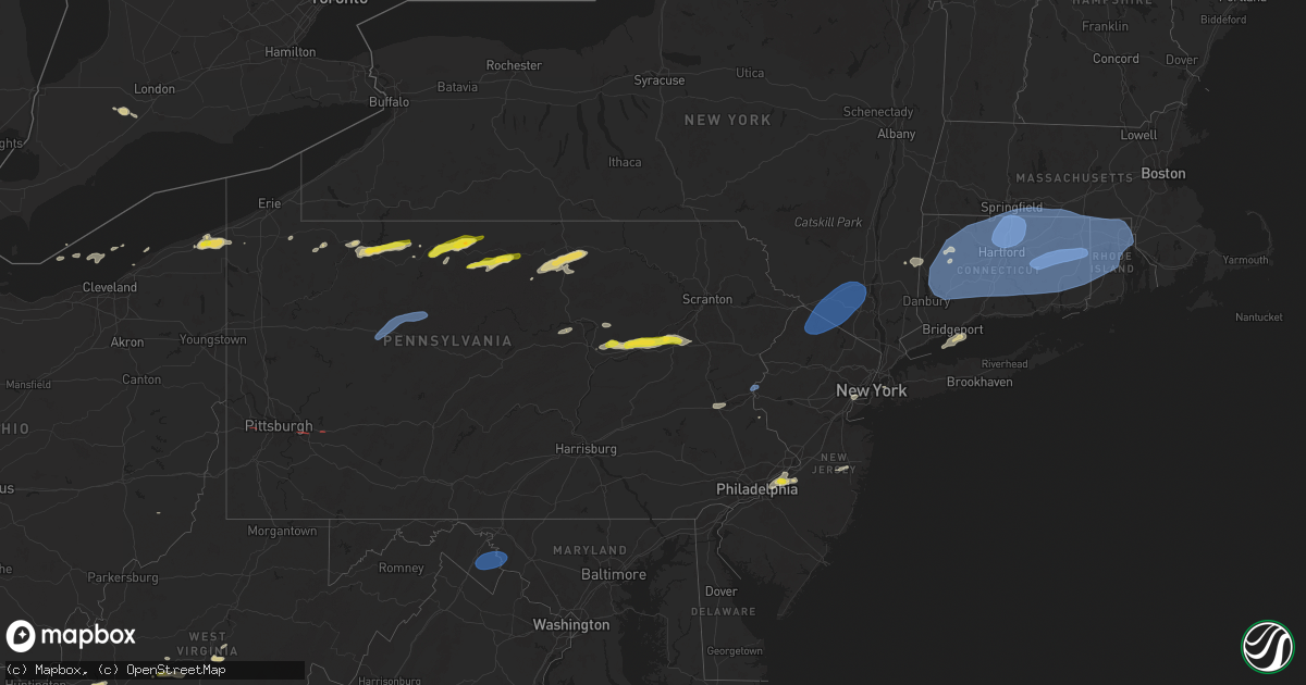
Hail Map on June 26, 2024
Get this storm
June 26 map
$229
one time, instant access
Download today. No call, no setup
Keep the $229
Bought the map and want the full workflow? Apply the entire $229 to a subscription within 7 days. None of it is wasted.
Every map, not just this one
This buys you this map. Subscription and you get every map we run, in the markets you choose from a few cities to whole states to nationwide. Plus real-time alerts the moment a storm fires.
Contact data
Name, contact info, occupancy, even credit band for addresses in the footprint. You go from where it hit to who to call.
Become the source they trust
Unlimited branding weather history reports on demand. You already have the documented answer ready for the property owner, and you are the one who showed up with it.
Property data and RoofTrace estimates
Pull up any address you have got, its value and the exact code rules for that jurisdiction, straight from One Click Code. Then RoofTrace estimates the squares, pitch, and roof value, priced the way you price.
States Impacted by Hail Map on June 26, 2024
- Iowa
- Texas
- Wisconsin
- Arizona
- Kansas
- Oklahoma
- Tennessee
- Arkansas
- Missouri
- Ohio
- Louisiana
- Pennsylvania
- Kentucky
- Georgia
- Mississippi
- South Carolina
- Florida
- Alabama
- Oregon
- West Virginia
- Idaho
- New Mexico
- Nevada
- North Carolina
- Washington
- Colorado
- Virginia
- Maryland
- Utah
- New Jersey
- New York
- Wyoming
- Connecticut
- Massachusetts
- Rhode Island
- Montana
Storm reports
South Carolina
| Date | Description |
|---|---|
| 06/26/20243:30 PM CDT | Sc dept of public safety reported a tree down blocking the roadway on tee vee rd |
| 06/26/20242:33 PM CDT | Tree down on tabor road. Time estimated by radar. |
Ohio
| Date | Description |
|---|---|
| 06/26/20246:18 PM CDT | A number of trees down in the northern part of the county. |
| 06/26/20246:14 PM CDT | Mping report of wind damage. |
| 06/26/202412:48 PM CDT | Trees down in monroe township. Time estimated from radar. |
| 06/26/202412:13 PM CDT | Tree with around 12 inch diameter snapped at its base... Among other large trees branches downed as well. |
| 06/26/202412:08 PM CDT | Tree fell on power lines. |
| 06/26/202411:54 AM CDT | Large tree was blown down across sanborn rd partially blocking the roadway. |
| 06/26/202411:53 AM CDT | Trees down in elmore 4 miles east of the high school. Time estimated from radar. |
| 06/26/202411:21 AM CDT | A few trees and limbs down in toledo. |
Kentucky
| Date | Description |
|---|---|
| 06/26/20246:57 PM CDT | Corrects previous tstm wnd dmg report from 1 ne haywood. Tree down on scottsville road. |
| 06/26/20246:45 PM CDT | Tree down on peter creek road. |
| 06/26/20246:44 PM CDT | Report of tree down on jack hunt rd. |
| 06/26/20244:33 PM CDT | Tree down on a powerline near 32 bevins street east of prestonsburg. |
| 06/26/20244:14 PM CDT | Tree down near the intersection of howards branch road and se licking river road. |
| 06/25/20248:02 PM CDT | Tree down on scottsville road. |
Oregon
| Date | Description |
|---|---|
| 06/26/20242:45 PM CDT | Emergency manager reports 5-6 power poles snapped off at the base. Most of the roof on an onion shed torn off. |
Idaho
| Date | Description |
|---|---|
| 06/26/20245:50 PM CDT | A witness described multiple living... Mature douglas fir and grand fir trees snapped in half. After reviewing the radar data... It appears a microburst occurred. After |
| 06/26/20244:30 PM CDT | Via social media. |
| 06/26/20244:30 PM CDT | Killed 2 ducklings. |
| 06/26/20244:30 PM CDT | Itd fall river id. |
| 06/26/20243:25 PM CDT | Large diameter branch fell on powerline and started house fire causing significant damage to the structure. |
| 06/26/20241:39 AM CDT | Mesonet station mofi1 moburg canyon raws. |
Alabama
| Date | Description |
|---|---|
| 06/26/20246:57 PM CDT | A tree fell... Likely due to thunderstorm outflow... Blocking a portion of u.s. Highway 278 in southeast cherokee county. Time estimated by radar. |
| 06/26/20245:42 PM CDT | Trees were blown down on weoka road... Grier road... And balm road. |
| 06/26/20245:05 PM CDT | Trees and power lines were blown down. Most likely from the |
| 06/26/20245:05 PM CDT | Trees and power lines were blown down. Most likely from the thunderstorm outflow ahead of the actual storms. |
| 06/26/20244:38 PM CDT | A tree was knocked down at the intersection of riverton rose trail and riviera cove. Time estimated by radar. |
| 06/26/20244:36 PM CDT | Trees and power lines were blown down on high school street. |
| 06/26/20244:20 PM CDT | A tree was blown down on moss drive near moss road. |
| 06/26/20244:09 PM CDT | A power pole was knocked over at 200 ingram street. Time estimated by radar. |
| 06/26/20243:57 PM CDT | Corrects previous tstm wnd dmg report from 2 nnw cloverdale for time. Report of a few trees down and power outages in the area along highway 79 north of valley crest dr |
| 06/26/20243:42 PM CDT | A tree was blown down on 2nd street. |
| 06/26/20243:28 PM CDT | Trees were knocked down across the roadway at 46 bethel church road. Time estimated by radar. |
| 06/26/20243:05 PM CDT | Several trees were blown down near paul allman road between camp oliver road and lock 17 road. |
| 06/26/20243:05 PM CDT | A few trees were blown down near paul allman road between camp oliver road and lock 17 road. |
| 06/26/20242:55 PM CDT | Metal roofing was damaged at a home along wheeler lake near browns ferry nuclear plant |
| 06/26/20242:54 PM CDT | A large tree was blown down on highway 11 near highway 80. |
| 06/26/20242:45 PM CDT | A power pole was knocked over at 85 veterans drive. Time estimated by radar. |
| 06/26/20242:20 PM CDT | A local report indicates 68 MPH wind near Tuscaloosa Regional Air |
| 06/26/20242:19 PM CDT | Small tree limbs were knocked down just north of moulton |
Virginia
| Date | Description |
|---|---|
| 06/26/20246:50 PM CDT | Broadcast media relayed report of a roof blown off a shed and small tree downed in bridgwater... Va along ridge road. Time estimated from radar. |
| 06/26/20246:20 PM CDT | Augusta county 911 center relayed at least 30 reports of downed trees and power lines across the county... Especially in the southwestern portion... Including christian |
| 06/26/20245:31 PM CDT | 911 call center reported numerous trees and powerlines down across essex county including near the intersection between howerton road and white marsh road. Time estimat |
| 06/26/20245:23 PM CDT | A trained spotter reported widespread damage in the village area west of callao with numerous trees uprooted and snapped along with powerlines down. Time estimated from |
| 06/26/20245:19 PM CDT | The 911 call center reported numerous trees an westmoreland pa 4039 7957 report from mping: trees uprooted or snapped; roof blown off. Time estimated b |
| 06/26/20245:19 PM CDT | The 911 call center reported numerous trees and powerlines down across richmond county including the farnham area and canal road. Time estimated from radar. |
| 06/26/20245:15 PM CDT | Caller reported multiple trees damaged/downed and damage to a barn roof. |
| 06/26/20245:14 PM CDT | The 911 call center reported numerous trees and powerlines down across northumberland county including across bon harbor road. Time estimated from radar. |
| 06/26/20245:14 PM CDT | The 911 call center reported numerous trees down across king and queen county including near the intersection of richmond tappahannock highway and bruington road. Time |
| 06/26/20244:53 PM CDT | Numerous trees down across king william county including around upshaw road... Mill road... And king william road. Time estimate from radar. |
| 06/26/20244:50 PM CDT | The 911 call center reported numerous trees and powerlines down across essex county including across richmond highway. Time estimated from radar. |
| 06/26/20244:38 PM CDT | Thunderstorm winds blew down seven trees and took shingles off a house and a small barn on wheatland road. |
| 06/26/20243:31 PM CDT | Tree down in the 4000 block of massaponax church road |
| 06/26/20243:00 PM CDT | Numerous trees downed along sunset loop and adjacent roads on the western side of lake anna... Along the spotsylvania/louisa county line. |
| 06/26/20243:00 PM CDT | Numerous trees downed along sunset loop and adjacent roads on t |
| 06/26/20242:56 PM CDT | A former nws employee reported multiple trees down as well as damage to some homes at lake anna. Time estimated from radar. |
| 06/26/20242:50 PM CDT | Tree down in the 15000 block of orange springs road |
| 06/26/20242:50 PM CDT | Tree down near the intersection of belmont road and jones powell road |
| 06/25/20249:15 PM CDT | The roanoke city 911 center reported that a power line was down across the road at the intersection of persinger road and brambleton road in the cave spring area of the |
| 06/25/20248:56 PM CDT | Delayed report. Video received of power lines flashing and power outage in the hybla valley area. |
| 06/25/20248:54 PM CDT | Delayed report. City of alexandria 911 center received 9 separate calls for trees and power lines downed. |
| 06/25/20248:05 PM CDT | County 911 center reported several downed trees across the county... With one tree onto power lines. |
| 06/25/20248:05 PM CDT | Delayed report. 911 center reported four trees down across the county from varioius storms last evening. |
| 06/25/20248:03 PM CDT | Large tree fell onto the road at the intersection of catharpin road & catharpin valley drive. |
| 06/25/20247:56 PM CDT | Trees down along millford rd between sweetfern ln and john wolford rd |
| 06/25/20247:50 PM CDT | Multiple trees were reported down along monrovia road to where brick church road/route 20 meet. |
| 06/25/20247:43 PM CDT | Along north blue ridge parkway... A few trees were down including one onto a transformer. Time based on radar. |
| 06/25/20247:38 PM CDT | Large tree branch down at the 4600 block of pelham rd. Winds estimated between 50 and 60 mph. |
| 06/25/20247:38 PM CDT | Large tree branch down on the 4600 block of pelham rd. Winds estimated between 50 and 60 mph. |
| 06/25/20247:33 PM CDT | Per 911 reports... There was an area of trees down on snow mountain road |
| 06/25/20247:30 PM CDT | A few trees down along bacon hollow road with time of reports based on radar. |
| 06/25/20247:24 PM CDT | Page county 911 center reported several trees down along us340 in the far northern part of the county. There are approximately 1000 power outages across the county. |
| 06/25/20247:15 PM CDT | Broadcast media relayed reports of multiple power lines downed on sapling ridge road... S east side highway... Near route 33. Time estimated from radar. |
| 06/25/20247:15 PM CDT | Warren county fire and 911 reported multiple trees down across the county... With one tree onto a home. Over 3...000 without power in the county. |
| 06/25/20247:02 PM CDT | Shenandoah county 911 reported several trees down in the edingurg area. Time estimated from radar. |
Arkansas
| Date | Description |
|---|---|
| 06/26/20241:27 PM CDT | Corrects previous tstm wnd dmg report from 2 nnw magnolia. Law enforcement received reports of trees down along us hwy 371 north of magnolia. Numerous trees reported do |
| 06/26/20241:27 PM CDT | Corrects previous tstm wnd dmg report from 2 nnw magnolia. Law enforcement received reports of trees down along hwy 98 near emerson. Numerous trees reported downed acro |
| 06/26/20241:17 PM CDT | Law enforcement received reports of trees down along us hwy 371 north of magnolia. Numerous trees reported downed across columbia county. |
| 06/26/202412:30 PM CDT | Report of a tree down on north cunningham st... North murphy st... And 30th st in lewisville... Ar... With power lines also down. |
| 06/26/202412:25 PM CDT | Law enforcement reported multiple trees down along hwy 71 in doddridge. |
| 06/26/202411:46 AM CDT | Kpbf measured wind gust. |
| 06/26/202411:30 AM CDT | Tree reported down between ashdown and forman. Time estimated by radar. |
| 06/26/202410:55 AM CDT | A tree was knocked down across hwy 270. |
| 06/26/20249:32 AM CDT | Multiple trees blown down. |
| 06/26/20249:30 AM CDT | Multiple trees blown down. |
| 06/26/20247:25 AM CDT | Strong thunderstorm wind uprooted a couple trees and snapped large tree limbs. |
Pennsylvania
| Date | Description |
|---|---|
| 06/26/20246:59 PM CDT | Large trees and branches down along 4th and 5th streets in the mellon plan neighborhood of monroeville. Siding also removed on a couple of houses along 5th street |
| 06/26/20246:59 PM CDT | Numerous calls of tree damage for north versailles and east mckeesport area. Time estimated by radar. |
| 06/26/20246:57 PM CDT | Report from mping: trees uprooted or snapped; roof blown off. Time estimated by radar. |
| 06/26/20246:50 PM CDT | Limbs down in squirrel hill south |
| 06/26/20246:42 PM CDT | Mping report of wind damage. |
| 06/26/20246:38 PM CDT | Electrical services ripped out of home. Outbuilding damaged by trees on 3rd street. Possible tornado. |
| 06/26/20246:38 PM CDT | Tree uprooted on vincennes avenue. Structural damage to home. Tornado possible. |
| 06/26/20246:35 PM CDT | Tree and wires down on road. |
| 06/26/20246:35 PM CDT | Lots of tree damage along a 1/2 mile path. Likely tornado |
| 06/26/20246:34 PM CDT | This location is near end of track of low end ef1 tornado with winds around 90 mph. The tornado skipped along the path and uprooted or snapped trees along the path star |
| 06/26/20246:32 PM CDT | Possible tornado. Damage and trees down at donaldson park... Donaldson elementary... And north fayette municipal bldg. |
| 06/26/20246:30 PM CDT | Trees down at north branch road and seabright road. |
| 06/26/20246:27 PM CDT | Tree down on wires; on fire. |
| 06/26/20246:25 PM CDT | Tree and wires down next to house. |
| 06/26/20246:24 PM CDT | Tree down on road. |
| 06/26/20246:13 PM CDT | Large tree down on top of a garage and several cars near 8th and wood street. Time estimated. |
| 06/26/20246:11 PM CDT | Power lines and trees down in hellertown. Time estimated. |
| 06/26/20246:10 PM CDT | Trained spotter measures 59 mph wind gust. |
| 06/26/20246:10 PM CDT | Trained spotter measures 59 mph wind |
| 06/26/20246:10 PM CDT | Trees down acr |
| 06/26/20246:10 PM CDT | Trees down across the road on center street in bethlehem. Time estimated. |
| 06/26/20246:10 PM CDT | Large tree branches down across columbia street in bethlehem. Time estimated. |
| 06/26/20246:09 PM CDT | Large tree uprooted and lying across road on n ulster street. Time estimated. |
| 06/26/20246:05 PM CDT | Several large branches snapped off that are 3-4 inches thick. No damage to structures. |
| 06/26/20245:58 PM CDT | Trained spotter relays report of 58.1 mph wind gust on a calibrated vortex inspeed. |
| 06/26/20245:57 PM CDT | Large branches down across road in upper macungie twp. Time estimated. |
| 06/26/20245:54 PM CDT | Wires down with a smoking pole. |
| 06/26/20245:53 PM CDT | Beckers rd - wires down arching and sparking in alsace twp. |
| 06/26/20245:51 PM CDT | Multiple trees down across roads in pocono pines. Time estimated. |
| 06/26/20245:50 PM CDT | Several trees down in the lake harmony area. Time estimated from radar. |
| 06/26/20245:48 PM CDT | Wires down across railroad tracks and on roadway near leesport ave and snyder rd in ontelaunee twp. |
| 06/26/20245:47 PM CDT | Nws storm survey conducted on wind damage in kidder township near lake harmony. Path of snapped and uprooted trees began on chalet court. Along chalet court and lupine |
| 06/26/20245:45 PM CDT | Corrects previous non-tstm wnd dmg report from maiden creek. Large tree uprooted over a driveway. |
| 06/26/20245:43 PM CDT | Wires down and trees blocking the road. |
| 06/26/20245:43 PM CDT | Tree down near intersection of angora rd and warner rd in lower alsace twp. |
| 06/26/20245:40 PM CDT | Tree down on road. |
| 06/26/20245:38 PM CDT | Tree down on road. |
| 06/26/20245:35 PM CDT | Delayed report. Numerous trees |
| 06/26/20245:35 PM CDT | Several trees down from mahoning township to franklin township. Time estimated from radar. |
| 06/26/20245:31 PM CDT | Delayed report. Centre twp: shartlesville rd & trolly rd - tree & wires down. Time estimated. |
| 06/26/20245:30 PM CDT | Tree down on road. |
| 06/26/20245:26 PM CDT | Wires down on irish creek rd in penn twp. |
| 06/26/20245:25 PM CDT | Numerous reports of trees and wires down in rush... Rahn... Walker... And west penn township in eastern schuylkill county. |
| 06/26/20245:22 PM CDT | Tree down on port clinton ave with power lines down. |
| 06/26/20245:20 PM CDT | Tree down on the road. |
| 06/26/20245:20 PM CDT | Trees down on road. |
| 06/26/20245:17 PM CDT | Tree down on road. |
| 06/26/20245:15 PM CDT | A local report indicates 1.00 inch wind near Dorrance |
| 06/26/20245:11 PM CDT | Numerous trees down and barn damage along fowlersville road. |
| 06/26/20245:10 PM CDT | Trees down on road. |
| 06/26/20245:08 PM CDT | Numerous downed trees... Along with building damage... Occurred in roughly a 4 mile path from lightstreet eastward to briar creek township. Inclusive of the damage was |
| 06/26/20245:08 PM CDT | Numerous trees and wires down in the pottsville area |
| 06/26/20245:05 PM CDT | Trees and wires down. |
| 06/26/20245:02 PM CDT | Trees uprooted or snapped; roof blown off. |
| 06/26/20244:55 PM CDT | Multiple trees and wires down along rt 11. |
| 06/26/20244:55 PM CDT | Multiple trees down along the road. |
| 06/26/20244:55 PM CDT | Tree down on structure. Partial collapse. |
| 06/26/20244:53 PM CDT | Multiple trees and wires down. Nj 4064 7460 nj dot - stmc: downed tree on i-78 eastbound west of exit 33 - cr 525/liberty |
| 06/26/20244:53 PM CDT | Multiple trees and wires down. |
| 06/26/20244:50 PM CDT | 1.0 inch |
| 06/26/20244:50 PM CDT | Tree down on wires. |
| 06/26/20244:50 PM CDT | Update to previous lsr. Nws state college surveyed severe downburst with even higher winds in columbia county... But estimated 60 mph gusts when it reached luzerne incl |
| 06/26/20244:50 PM CDT | Roof lifted off and dropped back onto gift shop... Causing total destruction of the building. |
| 06/26/20244:47 PM CDT | Report from mping: 1-inch tree limbs broken; shingles blown off. |
| 06/26/20244:45 PM CDT | 4 inch to 5 inch limbs down and trees uprooted along rt 72. Some large limbs hanging in the power lines. |
| 06/26/20244:45 PM CDT | 3 inch to 4 inch limbs down with small trees uprooted. |
| 06/26/20244:45 PM CDT | Multiple trees down across the roadway blocking one lane of rt 487. |
| 06/26/20244:43 PM CDT | Corrects previous hail report from 2 se stillwater. 1 inch |
| 06/26/20244:40 PM CDT | Tree down blocking ray st north of market st. |
| 06/26/20244:40 PM CDT | Trees down on the roadway. |
| 06/26/20244:40 PM CDT | Very large tree uprooted and into the side of a house crushing the porch. |
| 06/26/20244:39 PM CDT | Trees down both snapped off and uprooted... Large limbs strewn about... |
| 06/26/20244:37 PM CDT | Corrects previous tstm wnd dmg report from selinsgrove. Numerous trees down and roof damage. |
| 06/26/20244:35 PM CDT | Multiple trees down across main st partially blocking rt 209. One tree fell on a parked car. |
| 06/26/20244:34 PM CDT | Numerous trees down and roof damage. |
| 06/26/20244:25 PM CDT | Large tree limbs broken; power poles down. |
| 06/26/20244:25 PM CDT | Tree down at restaurant on lower paxton st. |
| 06/26/20244:25 PM CDT | Tree down. |
| 06/26/20244:25 PM CDT | Trees down on the roadway. |
| 06/26/20244:23 PM CDT | Report from mping: 1-inch tree limbs broken; shingles blown off. |
| 06/26/20244:21 PM CDT | Wires down in kettle creek. |
| 06/26/20244:20 PM CDT | 1 inch |
| 06/26/20244:20 PM CDT | Multiple trees down across the railroad tracks blocking the railway. |
| 06/26/20244:20 PM CDT | Wires down across red hill rd outside of daulphin... Pa. |
| 06/26/20244:20 PM CDT | Trees and wires down across both lanes of rt 11 blocking both lanes... Traffic being rerouted. |
| 06/26/20244:19 PM CDT | Multiple reports of down trees and snapped tree limbs. |
| 06/26/20244:10 PM CDT | Pole and wires down with the transformer on fire. Wires on the roadway. |
| 06/26/20244:05 PM CDT | Trees and wires down blocking the roadway. |
| 06/26/20244:05 PM CDT | Multiple trees and wires down in saint marys. |
| 06/26/20244:03 PM CDT | Trees and wires down in brockport. |
| 06/26/20244:02 PM CDT | Report from mping: 1-inch tree limbs broken; shingles blown off. |
| 06/26/20243:55 PM CDT | Trees on power lines with wires on the road blocking the road - arching and sparking with small fire. |
| 06/26/20243:55 PM CDT | Tree down and several large 5 inch limbs broken off and blocking the roadway. |
| 06/26/20243:55 PM CDT | Report from mping: 1-inch tree limbs broken; shingles blown off. |
| 06/26/20243:51 PM CDT | Trees and wires blocking roadway... Pole snapped. |
| 06/26/20243:50 PM CDT | Trees and lines down with tree on house on main street in brockway. |
| 06/26/20243:47 PM CDT | Trees and lines down with tree on house on main street in brockway. |
| 06/26/20243:46 PM CDT | Asos station kduj dubois airport gust 57 knots. |
| 06/26/20243:43 PM CDT | Multiple reports of trees down in morris. |
| 06/26/20243:43 PM CDT | Corrects previous tstm wnd dmg report from 1 wsw kistler. Wires down and trees blocking the road. |
| 06/26/20243:40 PM CDT | Trees snapped and uprooted. Power was out for 14 hours. |
| 06/26/20243:40 PM CDT | Trees blocking i-80 exit 86 on-ramp. |
| 06/26/20243:36 PM CDT | Trees down on waterfall lane. |
| 06/26/20243:24 PM CDT | Mping report of wind damage. |
| 06/26/20243:10 PM CDT | Downed tree in wires on us 6 both directions between short st and philips st. All lanes closed. Location intersection of short st in mount jewett [boro] - intersection |
| 06/26/20242:32 PM CDT | Corrects previous non-tstm wnd dmg report from 4 ne roulette. Tree down across the roadway blocking one lane of traffic at the intersection of raven hill rd and fishing |
| 06/26/20242:30 PM CDT | Tree down blocking the roadway - halsey rd near the intersection with rt 219. |
| 06/26/20242:22 PM CDT | Tree down blocking the roadway at the intersection of looker mountain trail and dallas rd. |
| 06/26/20242:20 PM CDT | Time estimate by radar |
| 06/26/20241:35 PM CDT | Hail reported during heavy rainfall from showers over mount jewett. |
| 06/26/20241:20 PM CDT | Tree down blocking the roadway. |
| 06/26/20241:12 PM CDT | Several reports of trees and wires down around warren and youngsville. Power outage in warren. |
| 06/26/202412:59 PM CDT | Union pd reported a tree fell on a ups delivery truck on concord st near bridge st. |
| 06/26/20248:22 AM CDT | Tree down on mae west road and tub run road. |
| 06/25/20249:46 PM CDT | Pictures from a trained spotter showed some downed trees and wires on baeder road... Rodman avenue and old york road. A downed tree landed onto a house on rodman avenue |
| 06/25/20249:45 PM CDT | Large tree branch down on wires with other large limbs down on paxson ave in glenside. |
| 06/25/20249:39 PM CDT | Wire down across the roadway on clouser hollow rd. |
| 06/25/20249:39 PM CDT | Tree down on the 4800 block of waggoners gap rd. |
| 06/25/20249:00 PM CDT | Multiple reports of trees and wires down in littlestown. |
| 06/25/20248:41 PM CDT | Report from mping: 3-inch tree limbs broken; power poles broken. |
| 06/25/20248:25 PM CDT | Trees down blocking the roadway... Wires down with a fire. |
| 06/25/20248:25 PM CDT | Multiple trees uprooted and/or snapped off with multiple power lines downed. |
| 06/25/20248:22 PM CDT | Tree down on mae west road and tub run road. |
| 06/25/20248:18 PM CDT | Trees down between farmington... Pa and elk park... Pa. |
| 06/25/20248:15 PM CDT | Multiple trees uprooted and down. |
| 06/25/20248:05 PM CDT | Trees uprooted and wires down - caused a small brush fire. |
| 06/25/20247:50 PM CDT | Trees down on the roadway. |
| 06/25/20247:50 PM CDT | Trees and wires down across the roadway. |
| 06/25/20247:44 PM CDT | Tree damage on w 15th street. No structural damage reported. Time estimated by radar. |
| 06/25/20247:42 PM CDT | Delayed report - multiple trees snapped and lawn furniture overturned. |
| 06/25/20247:31 PM CDT | Report from mping: 3-inch tree limbs broken; power poles broken. Time estimated from radar. |
| 06/25/20247:31 PM CDT | Possible tornado. Trees down and debris. |
| 06/25/20247:31 PM CDT | Report from mping: trees uprooted or snapped; roof blown off. Time estimated by radar. |
| 06/25/20247:31 PM CDT | Report from mping: 3-inch tree limbs broken; power poles broken. Time estimated by radar. |
| 06/25/20247:30 PM CDT | Trees down along pizza barn road |
| 06/25/20247:30 PM CDT | Storm survey confirms ef-0 tornado tree damage along a short stretch of newport road nw of blairsville... Pa. Details on the path length and width will come at a later |
| 06/25/20247:27 PM CDT | An ef-0 tornado occurred along dairy farm road. A public information statement will follow. |
| 06/25/20247:26 PM CDT | Damage to trees and trailer coincident with a circulation evident on radar. Possible tornado. |
| 06/25/20247:23 PM CDT | Numerous broken trees. Siding ripped off garage... And debris laying all around. This was in direct path of velocity couplet on doppler radar and just downstream of a t |
| 06/25/20247:22 PM CDT | Roof and structural damage. Trees down. |
| 06/25/20247:19 PM CDT | Barn destroyed along hannastown rd. Possible tornado. |
| 06/25/20247:19 PM CDT | Corrects previous tstm wnd dmg report from 4 w new alexandria. Wrong date and time. Report from mping: trees uprooted or snapped; roof blown off. Likely a tornado; time |
| 06/25/20247:18 PM CDT | Multiple trees uprooted. |
| 06/25/20247:15 PM CDT | Several trees reported down along winter ln. Likely tornado |
| 06/25/20247:15 PM CDT | Report from mping: 3-inch tree limbs broken; power poles broken. Time estimated from radar... Where 79 knot doppler radar velocities passed over location at about 2...5 |
| 06/25/20247:15 PM CDT | This is in the path of distinct velocity couplet on doppler radar... And just upstream from a tds signature just a few minutes later. Path of big trees snapped in half |
| 06/25/20247:13 PM CDT | Report from mping: trees uprooted or snapped; roof blown off. Time estimated by radar... And this likely a tornado. |
| 06/25/20247:13 PM CDT | Storm survey confirms tornado damage in a swath just south of us highway 22 from south of delmont to southwest of shieldsburg and new alexandria. Details on the path le |
| 06/25/20247:12 PM CDT | Possible tornado. Trees snapped near cloverleaf golf course. |
| 06/25/20247:12 PM CDT | Report from mping: trees uprooted or snapped; roof blown off. Time estimated by radar. This is likely a tornado. |
| 06/25/20247:09 PM CDT | Tree damage noted between harrison city export road and minicipal circle. |
| 06/25/20247:09 PM CDT | Report from mping: trees uprooted or snapped; roof blown off. Time estimated by radar. Reported as wind damage... But lies in path of tds and almost certainly a tornado |
| 06/25/20247:08 PM CDT | Multiple calls for trees and wires down across murrysville. Time estimated from radar. |
| 06/25/20247:08 PM CDT | Reported in harrison city. Large trampoline moved... Many trees down. A few traffic lights down and without power. Time estimated by radar. Likely a tornado. |
| 06/25/20247:08 PM CDT | Report from mping: 3-inch tree limbs broken; power poles broken. Time estimated from radar. |
| 06/25/20247:07 PM CDT | Trees down. |
| 06/25/20247:07 PM CDT | Westmoreland county department of public safety reports heavy damage to the i-76 turnpike maintenance shed in penn township. Time estimated by radar. This was in the pa |
| 06/25/20247:06 PM CDT | Trees down. Reported as wind damage... But almost certainly a tornado based on tds observed on radar in this area. Time estimated based on radar. |
| 06/25/20247:06 PM CDT | Large trees snapped and uprooted... And large branches snapped off along sandy hill rd and country view dr. No structural damage noted |
| 06/25/20247:05 PM CDT | Many trees snapped. Tds in area. Time estimated by radar. |
| 06/25/20247:04 PM CDT | Radar confirmed tornado debris signature |
| 06/25/20247:03 PM CDT | Probable tornado based on tds occurrence. Multiple large trees down on pine hollow road. |
| 06/25/20247:02 PM CDT | Time estimated by radar. Trees down... Wires down... And damage to a pool. |
| 06/25/20247:01 PM CDT | Trees down on mosside boulevard near signal hill drive. Likely tornado |
| 06/25/20247:01 PM CDT | Report from mping: 3-inch tree limbs broken; power poles broken. Time estimated from radar. Likely a tornado. |
Louisiana
| Date | Description |
|---|---|
| 06/26/20242:40 PM CDT | Reports of multiple trees down across the town of robeline. |
| 06/26/20242:35 PM CDT | Report of tree down on holliman road near hwy 146. |
| 06/26/20242:30 PM CDT | Reports of multiple trees down across the town of campti. |
| 06/26/20242:17 PM CDT | Tree down on a powerline at the junction of highway 371 and joe bill adcock road. Time estimated by radar. |
| 06/26/20242:08 PM CDT | Tree reported down along hwy 5 in desoto parish... La. |
| 06/26/20241:45 PM CDT | Reports of numerous trees down across the parish: some locations include harris road... Near la 2 and lisbon landing... And on hwy 79. |
| 06/26/20241:19 PM CDT | Shv regional airport reported a gust of 63 mph. |
| 06/26/20243:34 AM CDT | Asos station knew new orleans lakefront airport. |
Rhode Island
| Date | Description |
|---|---|
| 06/26/202410:17 AM CDT | Time estimated by radar. Public report of trees snapped and limbs downed. |
| 06/25/202410:25 PM CDT | Tree and high tension wires downed near the intersection of woodhaven at scarborough road. Time estimated from radar. |
| 06/25/202410:23 PM CDT | Nws storm survey determined that an ef-1 tornado with maximum wind speeds of around 100 mph affected lincoln and cumberland... Ri and north attleborough... Ma. Many lar |
| 06/25/202410:22 PM CDT | Several trees and wires down on lonsdale ave. Time estimated from radar. |
| 06/25/202410:21 PM CDT | Large tree downed near intersection of dorr st and maybury st. Time estimated from radar. |
| 06/25/202410:21 PM CDT | Tree downed onto home on new river road. Time estimated from radar. |
| 06/25/202410:21 PM CDT | Trees downed on great road. Time estimated from radar. |
| 06/25/202410:21 PM CDT | Tree downed... Which knocked down a chimney. Time estimated from radar. |
| 06/25/202410:21 PM CDT | Tree through house on river road. No injuries reported. Time estimated from radar. |
| 06/25/202410:21 PM CDT | Several trees downed. Some on homes... But no injuries reported. Most concentrated damage roughly 1/4 to 1/2 mile east of mendon road. Time estimated from radar. |
| 06/25/202410:20 PM CDT | Huge trees downed on pat drive. Time estimated from radar. |
| 06/25/202410:20 PM CDT | Dexter rock road wires and trees downed across the roadway. People stranded at a restaurant due to trees blocking roadway. |
| 06/25/202410:19 PM CDT | Lots of trees downed on breakneck hill road. Time estimated from radar. |
| 06/25/202410:18 PM CDT | Several trees downed. Broad street at sheldon street... Matthewson street and burnside street. Time estimated from radar. |
| 06/25/202410:18 PM CDT | Trees downed on rowley street and near the intersection of river avenue at pleasant valley parkway. Time estimated from radar. |
| 06/25/202410:18 PM CDT | Tree and power lines downed at douglas pike at whipple road. Time estimated from radar. |
| 06/25/202410:17 PM CDT | Large tree downed on north street. Time estimated from radar. |
| 06/25/202410:16 PM CDT | Tree down blocking road near intersection of farnum pike and greenville road at route 7. Time estimated from radar. |
| 06/25/202410:14 PM CDT | Several trees downed or uprooted. Time estimated from radar. |
| 06/25/202410:12 PM CDT | Many large trees downed near intersection of cooper and douglas hook road. Time estimated from radar. |
| 06/25/202410:10 PM CDT | Few trees downed. One for route 44 at dorr drive and indian trail. Time estimated from radar. |
New Jersey
| Date | Description |
|---|---|
| 06/26/20246:59 PM CDT | Personal weather station: lake panorama - knjverno10 gusted to 62 mph. |
| 06/26/20246:55 PM CDT | Trees down on maple path and mcgregor ave in mount arlington... Nj. Time estimated by radar. |
| 06/26/20246:55 PM CDT | Trained spotter sent in pictures of large trees on the ground. Time estimated from radar. |
| 06/26/20246:54 PM CDT | Spotter network: multiple downed branches in yard. Branch diameters around 6-8 inches. Time estimated. |
| 06/26/20246:52 PM CDT | Nj dot - stmc: downed wires on i-287 both directions south of exit 30 - north maple ave |
| 06/26/20246:51 PM CDT | Nj dot - stmc: downed tree and downed wires on nj 23 both directions north of wantage school rd |
| 06/26/20246:48 PM CDT | Nj dot - stmc: downed tree on i-78 eastbound west of exit 33 - cr 525/liberty corner rd/martinsville |
| 06/26/20246:46 PM CDT | Nj dot - stmc: downed tree on us 206 both directions cr 517 |
| 06/26/20246:46 PM CDT | Delayed report. Trees and power lines down around frankford twp. Time estimated. |
| 06/26/20246:44 PM CDT | Tree down across powerlines and on roadway along county line rd. |
| 06/26/20246:39 PM CDT | Trees... Wires and power poles down on rockport road near allen road. Time estimated. |
| 06/26/20246:36 PM CDT | Several trees down report around lebanon. Time estimated. |
| 06/26/20246:35 PM CDT | Several trees down and a measured wind gust to 59 mph. Time estimated from radar. |
| 06/26/20246:35 PM CDT | Pictures show several large tree limbs down... A few trees down with even one tree snapped. Time estimated from radar. |
| 06/26/20246:30 PM CDT | Multiple trees down across tewksbury. Time estimated from radar. |
| 06/26/20246:29 PM CDT | Nj dot - stmc: downed tree on us 46 westbound east of pequest hatchery |
| 06/26/20246:21 PM CDT | Reports of multiple wires down in and around belvidere. Time estimated. |
| 06/25/202411:18 PM CDT | Downed trees resulted in power outages. Time estimated from radar. |
| 06/25/202411:02 PM CDT | Tree damage resulted in power outages. Time estimated from radar. |
| 06/25/202411:00 PM CDT | Some downed trees resulted in power outages. Time estimated from radar. |
| 06/25/202410:15 PM CDT | A local report indicates 1.00 inch wind near 1 NW Rancocas |
| 06/25/20248:04 PM CDT | Large tree down over road. |
| 06/25/20248:04 PM CDT | Tree on house on krysch lane in wyckoff nj. |
| 06/25/20247:57 PM CDT | *** 1 inj *** tree on person with ems responding near north munn avenue in east orange nj. |
| 06/25/20247:57 PM CDT | Tree on house in washington township nj. |
| 06/25/20247:57 PM CDT | Transformer explosion on cripplebush road in old tappan nj. |
| 06/25/20247:50 PM CDT | Tree on house on warburton avenue in hawthorne nj. |
| 06/25/20247:45 PM CDT | Very large oak tree snapped on property near orangeburgh road in river vale nj. |
| 06/25/20247:40 PM CDT | Multiple trees/branches down and power outages due to trees taking out power lines. |
| 06/25/20247:40 PM CDT | Mesonet station fw2280 jersey city measured a 59 mph wind gust. |
| 06/25/20247:40 PM CDT | Multiple trees and wires down across wood-ridge nj. |
| 06/25/20247:40 PM CDT | Multiple trees and wires down across lodi nj. |
| 06/25/20247:38 PM CDT | *** 1 inj *** corrects previous tstm wnd dmg report from 1 ese park ridge to include injury. Tree on house on park avenue in park ridge nj. |
| 06/25/20247:38 PM CDT | Tree on house on park avenue in park ridge nj. |
| 06/25/20247:35 PM CDT | Wire and tree down with tree in flames on elm street in north arlin |
| 06/25/20247:35 PM CDT | Primary wire down on house causing housefire in belleville nj. |
| 06/25/20247:35 PM CDT | Wire and tree down with tree in flames on elm street in north arlington nj. |
| 06/25/20247:31 PM CDT | Corrects time from previous tstm wnd dmg report from ridgewood. Large tree down over road. |
| 06/25/20247:31 PM CDT | Corrects previous tstm wnd dmg report from 1 ese hawthorne to include corrected time. Tree on house on warburton avenue in hawthorne nj. |
| 06/25/20247:27 PM CDT | Corrects time from previous tstm wnd dmg report from 1 nne mahwah. Tree on house on krysch lane in wyckoff nj. |
| 06/25/20247:27 PM CDT | Downed tree on nj 17 southbound south of lake st |
| 06/25/20247:26 PM CDT | Tree on a house on hillside avenue in livingston nj. |
| 06/25/20247:25 PM CDT | Multiple trees down near north 11th |
| 06/25/20247:25 PM CDT | Multiple trees down near north 11th street in newark nj. |
| 06/25/20247:19 PM CDT | Large tree down on wires near orchard street and west holly street in cranford nj. |
| 06/25/20247:19 PM CDT | Large tree down over road near orange avenue and sutton place in cranford nj. |
| 06/25/20247:18 PM CDT | *** 1 fatal *** corrects previous tstm wnd dmg report from east orange to include fatality and adjust time based on radar. A tree fell on a 30 year old male near north |
| 06/25/20247:13 PM CDT | Downed trees in pompton plains. Wind gust estimated to be 60 mph. Time estimated from radar. |
West Virginia
| Date | Description |
|---|---|
| 06/26/20245:30 PM CDT | Tree down reported on helvetia-adolph road. |
| 06/26/20245:25 PM CDT | County 911 reports a tree down blocking traffic at cemetery rd. |
| 06/26/20245:15 PM CDT | Lines reported down. |
| 06/26/20245:00 PM CDT | County 911 reports a tree down... Approx 1 foot diameter... On warden lane. |
| 06/26/20245:00 PM CDT | Corrects previous tstm wnd dmg report from 1 nw sandstone. The summers county emergency manager reported that two trees were down on wv route 20 in the sandstone area. |
| 06/26/20245:00 PM CDT | The summers county emergency manager reported that a tree was down in the far northwest corner of the county on claypool road in the meadow creek area. The road was blo |
| 06/26/20245:00 PM CDT | The summers county emergency manager reported that two trees were down on wv route 20 in the sandstone area. |
| 06/26/20244:56 PM CDT | County 911 reports a tree down on wv 15 about 5 miles south of the braxton county line. |
| 06/26/20244:53 PM CDT | Corrects previous tstm wnd dmg report from 4 wsw buck. A couple trees were downed by thunderstorm winds along state route 20. The road was blocked from the downed trees |
| 06/26/20244:53 PM CDT | A couple trees were downed by thunderstorm winds along state route 20. |
| 06/26/20244:50 PM CDT | County 911 reported numerous reports of trees down in the southern part of the county... With power outages reported east of flatwoods. |
| 06/26/20244:50 PM CDT | Tree down on wv 15 near braxton and webster county line. |
| 06/26/20244:35 PM CDT | County 911 reported numerous reports of trees down in the southern part of the county... And power company status site shows multiple outages southwest of sutton... Alo |
| 06/26/20244:35 PM CDT | Tree down on lines on sutton lane just north of little otter road. |
| 06/26/20244:35 PM CDT | County 911 reports tree down in 2700 block of old turnpike road. |
| 06/26/20244:33 PM CDT | County 911 reports a tree down on lines on village ln south of interstate 79. |
| 06/26/20244:28 PM CDT | County 911 reports tree down on frametown road just east of elk river road. |
| 06/26/20244:20 PM CDT | The summers county emergency manager reported that a tree was down in the wiggins area on wildwood road. The road was blocked. |
| 06/26/20244:12 PM CDT | Also estimated 50mph winds. |
| 06/26/20244:09 PM CDT | Corrects previous tstm wnd dmg report from hinton. The summers county emergency manager reported that a tree was down in the elk knob area on wv route 9. The road was b |
| 06/26/20244:09 PM CDT | The summers county emergency manager reported that a tree was down in the elk knob area on wv route 9. |
| 06/26/20244:08 PM CDT | Tree reported down on foxview ln in bob white. |
| 06/26/20244:06 PM CDT | Tree down in the 30000 block of pond fork road. |
| 06/26/20244:06 PM CDT | Tree down in the 31000 block of pond fork road. |
| 06/26/20244:05 PM CDT | County 911 reports a tree down near intersection of spruce river rd and hewett creek rd. |
| 06/26/20243:47 PM CDT | Power company reports tree down on lines along wills creek rd. |
| 06/26/20243:45 PM CDT | Tree down on lines north of elkview. D powerlines down across richmon |
| 06/26/20243:45 PM CDT | Tree down on lines north of elkview. |
| 06/26/20243:19 PM CDT | County 911 reports a tree down on beech creek road... Blocking both lanes. |
| 06/26/20243:15 PM CDT | Tree down on lines along centennial drive. |
| 06/26/20243:05 PM CDT | Tree down at intersection of rocky fork road and amy road. |
| 06/26/20243:02 PM CDT | Tree down on beechcrest dr near intersection with big tyler road. |
| 06/26/20243:01 PM CDT | Power lines down at intersection of big tyler rd and alpine dr. |
| 06/26/20242:53 PM CDT | A couple of large branches from a tree in the yard down. Photo provided. Also nickel size hail. |
| 06/26/20242:50 PM CDT | Tree down at poca river rd. S and doc bailey rd. In poca. Time estimated from radar. |
| 06/26/202411:05 AM CDT | A trained spotter reported that one tree was down on u.s. 219 near maxwelton... Blocking the highway. |
| 06/25/20248:08 PM CDT | A local report indicates 65 MPH wind near 2 SW Shepherdstown |
Massachusetts
| Date | Description |
|---|---|
| 06/25/202411:05 PM CDT | Large tree downed on harrison st. Time estimated from radar. |
| 06/25/202411:05 PM CDT | Corrects previous tstm wnd dmg report from duxbury. Large tree downed on harrison st and winter street. Time estimated from radar. |
| 06/25/202411:00 PM CDT | Trees and wires downed. Time estimated from radar. |
| 06/25/202411:00 PM CDT | Several trees downed in town of pembroke. One fell into a home. No injuries reported. Time estimated from radar. |
| 06/25/202410:55 PM CDT | Trees and wires downed near woodbine ave and cushman street. Time estimated from radar. |
| 06/25/202410:54 PM CDT | Photo of several trees downed on route 58 in halifax... Ma. Time estimated from radar. |
| 06/25/202410:48 PM CDT | Lot of trees and wires down across town. Time estimated from radar. |
| 06/25/202410:41 PM CDT | Several trees downed across town of raynham. Northern portion of town most impacted. Did have a tree land on a home on prospect hill street... But their were no injurie |
| 06/25/202410:31 PM CDT | Two trees downed blocking one lane on locust avenue. Time estimated from radar. |
| 06/25/202410:30 PM CDT | Tree downed blocking road on greenwood drive. Time estimated from radar. |
| 06/25/202410:30 PM CDT | Multiple trees downed across town of attleboro. Tree downed on home on newport ave. Time estimated from radar. |
| 06/25/202410:29 PM CDT | Nws storm survey determined an ef-1 tornado with maximum speeds around steber way. A number of large hardwood and softwood trees were snapped and uprooted. Otherwise... |
| 06/25/202410:25 PM CDT | Several trees and wires downed on a couple of streets. Thacher street at black oak drive and newport ave near roy ave. Time estimated from radar. |
| 06/25/202410:25 PM CDT | Video of several large trees downed at seekonk high school. Time estimated from radar. |
| 06/25/202410:25 PM CDT | Caller reported the tops off about 10-12 mature hardwood trees on their property about 40 ft up in the air along providence street. Time estimated from caller and radar |
| 06/25/202410:24 PM CDT | Treed downed blocked one lane on pleasant street. Time estimated from radar. |
| 06/25/202410:23 PM CDT | Updated: storm survey indicated a microburst with winds estimated at 100 mph downed and snapped many trees in a wooded area near seekonk high school and in a school cou |
| 06/25/202410:23 PM CDT | Downed trees and roof damage at seekonk high school. Time estimated from radar. |
| 06/25/20247:10 PM CDT | Town law enforcement in ashland reports high tension powerlines were downed near grover st in ashland. Relayed by amateur radio. |
North Carolina
| Date | Description |
|---|---|
| 06/25/20247:21 PM CDT | Tree downed along stokes ferry rd. |
| 06/25/20247:07 PM CDT | Tree and 2 utility poles downed along lippard rd. Time estimated from radar and likely from sub-severe winds. |
Mississippi
| Date | Description |
|---|---|
| 06/26/20244:18 PM CDT | Tree down across pleasant grove rd. |
| 06/26/20244:15 PM CDT | A local report indicates 1.00 inch wind near 4 NNW Mill Creek |
| 06/26/20244:07 PM CDT | Heavy rainfall rates were causing ponding on streets and in poor drainage areas. |
| 06/26/20244:03 PM CDT | Tree down across hwy 513 at cr 151. |
| 06/26/20244:00 PM CDT | Tree down across cr 282 in the harmony community. |
| 06/26/20243:50 PM CDT | A couple trees down across roads... Along cr 350... And another near enterprise middle. |
| 06/26/20243:33 PM CDT | One lane of traffic was blocked due to fallen trees and power lines on ms highway 39 near blackwater-493 road. |
| 06/26/20243:30 PM CDT | A tree was blown down on pine springs road near the water tower. |
| 06/26/20243:15 PM CDT | Tree down across white road. |
| 06/26/20243:10 PM CDT | A large tree was blown down across both lanes of county road 23 in the 2500 block. |
| 06/26/20242:55 PM CDT | Tree down across part of hwy 8. |
| 06/26/20242:00 PM CDT | Large tree down blocking minerva road. |
| 06/26/20241:15 PM CDT | Five power poles were broken and several others were damaged along carson road due to strong outflow winds from nearby thunderstorms. |
| 06/26/202412:50 PM CDT | A tree was blown down onto power lines near briarwick drive. |
Wyoming
| Date | Description |
|---|---|
| 06/25/20247:19 PM CDT | A local report indicates 69 MPH wind near 1 N Cheyenne |
| 06/25/20247:15 PM CDT | A local report indicates 63 MPH wind near 1 N Cheyenne |
Oklahoma
| Date | Description |
|---|---|
| 06/26/202411:05 AM CDT | A tree was downed onto power lines near the redland ballpark on highway 3 in haworth. A pole was snapped here as well. |
| 06/26/202411:00 AM CDT | A 60 mph wind gust was measured at the idabel mesonet station. |
| 06/26/202410:45 AM CDT | *** 1 inj *** falling tree injured an individual in hochatown. |
| 06/26/20249:39 AM CDT | Large tree blown down. |
| 06/26/20249:22 AM CDT | Emergency manager reports roof damaged due to thunderstorm winds. |
| 06/26/20248:59 AM CDT | Multiple trees blown down. |
| 06/26/20248:56 AM CDT | A local report indicates 58 MPH wind near Stigler |
| 06/26/20248:52 AM CDT | Report of multiple power outages... Tree limbs down... And power lines damaged from thunderstorm winds. |
| 06/26/20248:52 AM CDT | Photo on social media showed multiple large tree branches down with most trees showing at least some damage. |
| 06/26/20248:26 AM CDT | Several trees down on roads. |
| 06/26/20248:17 AM CDT | A local report indicates 67 MPH wind near 1 NNE Okmulgee |
| 06/26/20248:08 AM CDT | A local report indicates 68 MPH wind near 3 E Summit |
| 06/26/20248:02 AM CDT | Multiple large tree limbs snapped. |
| 06/26/20247:48 AM CDT | Multiple large tree limbs snapped. |
| 06/26/20247:42 AM CDT | A local report indicates 58 MPH wind near 3 W Jenks |
| 06/26/20247:40 AM CDT | Photo of traffic light bar broken at hinge. |
| 06/26/20247:39 AM CDT | Multiple trees and power poles blown down. |
| 06/26/20247:35 AM CDT | Tree blown down. |
| 06/26/20247:31 AM CDT | A local report indicates 71 MPH wind near 4 WNW Tulsa |
| 06/26/20247:28 AM CDT | A local report indicates 58 MPH wind near 4 S Owasso |
| 06/25/20247:21 PM CDT | Report from mping: quarter |
| 06/25/20247:20 PM CDT | A local report indicates 59 MPH wind near 1 WSW Guymon |
| 06/25/20247:17 PM CDT | A local report indicates 1.00 inch wind near 1 NW Durant |
Colorado
| Date | Description |
|---|---|
| 06/25/20247:18 PM CDT | A local report indicates 59 MPH wind near 9 S Springfield |
Texas
| Date | Description |
|---|---|
| 06/26/20242:53 PM CDT | Several reports of trees down in and around lufkin. Time estimated by radar. |
| 06/26/20242:42 PM CDT | Two trees down near the intersection of 87 north and telephone road. Time estimated by radar. |
| 06/26/20242:35 PM CDT | Report of multiple trees down in the town of chireno. |
| 06/26/20242:20 PM CDT | Tree down near the junction of fm 343 and highway 69. Time estimated by radar. |
| 06/26/20242:20 PM CDT | Large tree down at sfa gardens. |
| 06/26/20242:15 PM CDT | Reports of multiple trees down in central heights and garrison. |
| 06/26/20241:30 PM CDT | Corrects previous tstm wnd dmg report from 1 ssw overton. Reports of trees down on fm 2089 south of overton. |
| 06/26/20241:30 PM CDT | Corrects previous tstm wnd dmg report from henderson. Reports of multiple trees down in henderson. |
| 06/26/20241:30 PM CDT | Corrects previous tstm wnd dmg report from 5 wsw tatum. Tree down about 5 miles sw of tatum on highway 43. |
| 06/26/202412:40 PM CDT | Marion county dispatch confirmed a few buildings on the southeast side of jefferson had their roofs removed due to high winds. Winds estimated at 70 to 80 mph with time |
| 06/26/202412:30 PM CDT | Tree down about 5 miles sw of tatum on highway 43. |
| 06/26/202412:30 PM CDT | Reports of multiple trees down in henderson. |
| 06/26/202412:30 PM CDT | Reports of trees down on fm 2089 south of overton. |
| 06/26/202411:55 AM CDT | Report of numerous trees and powerlines down on hwy 77 approximately 6 miles west of douglasville... Tx. |
| 06/26/202411:45 AM CDT | Reports of numerous trees down across bowie county. |
| 06/26/20244:05 AM CDT | A local report indicates 65 MPH wind near 4 W Childress |
| 06/25/20249:15 PM CDT | Shed attached to quonset hut destroyed. Picture of damage relayed by media. Time estimated from radar. |
| 06/25/20249:05 PM CDT | Large trees snapped and missing lawn furniture. |
| 06/25/20248:49 PM CDT | Quarter size hail reported along highway 377 north of whitesboro. |
| 06/25/20248:30 PM CDT | Outbuilding damaged. Trees downed at a residence. Crop damage. |
| 06/25/20248:29 PM CDT | A local report indicates 72 MPH wind near 1 SSW Panhandle |
| 06/25/20248:24 PM CDT | Broadcast media shares social media report with picture of snapped power pole and tree damage in sherwood shores. Time estimated by radar. |
| 06/25/20248:18 PM CDT | Golfball size hail reported in the cambridge shores area. |
| 06/25/20248:17 PM CDT | Metal awning roof torn off. Tree branches broken. Corrugated metal tangled. |
| 06/25/20248:14 PM CDT | Spotter network report of 2 inch hail. |
| 06/25/20248:09 PM CDT | A local report indicates 60 MPH wind near 3 W Pottsboro |
| 06/25/20248:02 PM CDT | A local report indicates 1.00 inch wind near 4 N Pottsboro |
| 06/25/20248:02 PM CDT | A local report indicates 1.00 inch wind near Pottsboro |
| 06/25/20247:22 PM CDT | A local report indicates 58 MPH wind near 9 NNE Sunray |
New York
| Date | Description |
|---|---|
| 06/26/20248:07 AM CDT | Tree and wires down on plass road and patricia drive in pleasant valley. |
| 06/25/20248:39 PM CDT | Downed wires from thunderstorm wind gust. |
| 06/25/20248:25 PM CDT | Multiple trees and wires down across east northport ny. |
| 06/25/20248:13 PM CDT | Tree down in roadway and on fire. Fire department dispatched. |
| 06/25/20248:13 PM CDT | Downed tree on ny 107 both directions at glen head road |
| 06/25/20248:11 PM CDT | Tree down on car. Fire department dispatched. |
| 06/25/20248:08 PM CDT | Tree down on ny 35 westbound west of spring street; ny 124 |
| 06/25/20248:07 PM CDT | Corrects previous tstm wnd dmg report from 2 ssw pleasant valley. Tree and wires down on plass road and patricia drive in pleasant valley. |
| 06/25/20248:07 PM CDT | Downed tree branch leaning on wires on freedom road near jb grill. |
| 06/25/20248:04 PM CDT | Tree down on ny 22 southbound south of birch hill rd |
| 06/25/20248:02 PM CDT | Tree and wires down on palen road near hararigan road resulting in blocked road. |
| 06/25/20248:02 PM CDT | Downed tree on ny 25a both directions at chestnut drive |
| 06/25/20248:01 PM CDT | Multiple trees down at noxon and manchester rds. Received via facebook. |
| 06/25/20248:00 PM CDT | Public photo of tree damage along route 44. |
| 06/25/20248:00 PM CDT | Tree down on occupied car near fort totten. Three people trapped. |
| 06/25/20248:00 PM CDT | Large tree blocking road. Time estimated from radar. |
| 06/25/20248:00 PM CDT | Trees down near wicks lane in malverne ny. |
| 06/25/20248:00 PM CDT | Trees down at the marriott on route 9 in poughkeepsie. |
| 06/25/20247:59 PM CDT | Tree down and downed wires on ny 139 northbound at plum brook road |
| 06/25/20247:58 PM CDT | Large trees down across vassar road from red oak mills to raymond avenue. |
| 06/25/20247:58 PM CDT | Trees and power lines down on hammersley avenue in the city of poughkeepsie. |
| 06/25/20247:57 PM CDT | Downed tree on northern state parkway eastbound exit ramp partially closed at exit 27s-shelter rock road |
| 06/25/20247:56 PM CDT | Trees down at beekman rd and sachs ct |
| 06/25/20247:56 PM CDT | Trees down at beekman rd and sachs ct. |
| 06/25/20247:55 PM CDT | Tree down on house with structural damage near 79th street and penelope avenue. |
| 06/25/20247:45 PM CDT | Picture of large tree down on police vehicle near congers ny and valley cottage ny. |
| 06/25/20247:45 PM CDT | Tree down on ny 100 southbound area of shingle house rd |
| 06/25/20247:43 PM CDT | Tree down and road closure on ny 9a southbound south of croton dam road; ny 134 |
| 06/25/20247:40 PM CDT | Tree down on ny 32 northbound at ruscitti rd |
| 06/25/20247:35 PM CDT | Large tree branch and wires down. |
| 06/25/20247:29 PM CDT | Awos station kmgj montgomery airport reported a 59 mph wind gust. |
| 06/25/20247:18 PM CDT | Trees and wires down on lakes road and osseo park road in monroe ny. |
| 06/25/20247:18 PM CDT | Wires down on lake view drive and trees and wires down on black meadow road and pine hill road. |
| 06/25/20247:17 PM CDT | Picture of large tree snapped and on house in goshen ny. |
| 06/25/20247:15 PM CDT | Picture of multiple trees down near mcnally street in goshen ny. |
| 06/25/20247:15 PM CDT | Wires down on lakes road and wires down on brook trail. |
| 06/25/20247:05 PM CDT | Multiple trees down in yard... One tree on car on blooms corners road in warwick ny |
| 06/25/20247:05 PM CDT | Multiple trees down in yard... One tree on car on blooms corners road in warwick ny. |
| 06/25/20247:05 PM CDT | Wires down on greenville turnpike and eatontown road in greenville ny. |
| 06/25/20247:00 PM CDT | Transformer and wires down on hilltop road. Trees and wires down on ridge road and minisink turnpike. |
Maryland
| Date | Description |
|---|---|
| 06/26/20246:49 PM CDT | Law enforcement reported a tree down across the intersection of merritt mill road and old ocean city road in salisbury. Time estimated from radar. |
| 06/26/20246:49 PM CDT | Power lines reported down on a road in parsonsburg. Time estimated from radar. |
| 06/26/20246:44 PM CDT | Broadcast meteorologist reported estimated winds to 55 to 65 mph across north salisbury. |
| 06/26/20246:40 PM CDT | Corrects time of previous tstm wnd dmg report from 1 wsw chesapeake height based on radar/observational data. Law enforcement reported a tree down across the intersecti |
| 06/26/20246:38 PM CDT | Corrects time of previous tstm wnd gst report from salisbury based on radar/observational data. Broadcast meteorologist reported estimated winds to 55 to 65 mph across |
| 06/26/20246:38 PM CDT | Trees down south of princess anne on charles boston and fairmount rd. Time estimated from radar data. |
| 06/26/20246:35 PM CDT | Sporadic damage occurred between hebron and northern salisbury with a few trees down. Time estimated from radar. |
| 06/26/20246:13 PM CDT | Weatherflow sensor xcrs at crisfield measured a peak wind gust of 52 knots. |
| 06/26/20246:05 PM CDT | Several large tree branches down causing damage to vehicles in crisfield. Report relayed via social media. Time estimated from radar data. |
| 06/26/20245:30 PM CDT | Hoopers island mesonet measured a peak wind gust of 61 knots. |
| 06/26/20245:12 PM CDT | The 911 call center reported multiple trees down in the kinsale area including on skipjack road. |
| 06/26/20245:10 PM CDT | Patuxent nas asos knhk measured a peak wind gust of 53 knots / 61 mph. |
| 06/26/20245:10 PM CDT | Calvert county 911 center reported numerous trees down in the solomons area. Time estimated from radar. |
| 06/26/20245:04 PM CDT | Several large trees down snapped midway down the trunk due to thunderstorm winds along town creek drive and east sunrise drive. |
| 06/26/20245:04 PM CDT | Multiple trees down due to thunderstorm winds along river road. |
| 06/26/20245:03 PM CDT | Multiple trees down and uprooted due to thunderstorm winds at the intersection of pine road and town creek drive. |
| 06/26/20244:59 PM CDT | Delayed report. Two large trees downed... One onto a shed... And several small trees downed at a property along barley court in lexington park. Numerous other small and |
| 06/26/20244:59 PM CDT | St. Mary's county 911 center relayed at least 20 reports of trees down in the great mills area. Along st. Andrews church road... Near intersection of indian bridge road |
| 06/26/20244:55 PM CDT | Delayed report. Public reported via video and photos... Several large trees downed on property near evans road in the huntingtown area. Many other adjacent properties a |
| 06/26/20244:52 PM CDT | Calvert county 911 center reported a few trees down in the huntingtown area. Time estimated from radar. |
| 06/26/20244:25 PM CDT | A couple trees were down in waldorf. Oss the road on center street in bethlehem. Time estimated. |
| 06/26/20244:25 PM CDT | A couple trees were down in waldorf. |
| 06/26/20244:22 PM CDT | A tree was down in la plata. |
| 06/25/20249:50 PM CDT | 911 call center reports of trees & wires down around the intersection of stoney batter road and mt. Vista road. |
| 06/25/20249:36 PM CDT | Weatherflow xhpr at lower hooper island measured a peak wind gust of 52 knots. |
| 06/25/20249:26 PM CDT | Multiple trees down around crownsville... Md. |
| 06/25/20249:17 PM CDT | Multiple trees down between dunkirk and chesapeake beach. |
| 06/25/20248:51 PM CDT | The 911 call center reported several trees and power lines down around the colonial beach area. Time estimated from radar. |
| 06/25/20248:35 PM CDT | Multiple trees down around thurmont. |
| 06/25/20248:26 PM CDT | Multiple trees down on trego road in rohrersville. |
| 06/25/20248:24 PM CDT | Multiple trees down in wolfsville... Md. |
| 06/25/20248:13 PM CDT | Multiple trees down on gruber road near clear spring. |
Tennessee
| Date | Description |
|---|---|
| 06/26/20245:32 PM CDT | Facebook photo of a tree down on a house on denny road. |
| 06/26/20245:27 PM CDT | Multiple reports of trees down in springfield. Time estimated via radar. |
| 06/26/20245:19 PM CDT | Tree down in the 4100 block of lahr road in springfield. Time estimated. |
| 06/26/20245:16 PM CDT | Powerlines downed on west division street near pascal drive... Forcing the closure of w division street. Time estimated via radar. |
| 06/26/20245:13 PM CDT | Facebook report of tree snapped on garland drive. |
| 06/26/20245:11 PM CDT | Facebook video of a tree snapped on luree lane. |
| 06/26/20245:11 PM CDT | Tree reported down in watertown on highway 70. Time estimated from radar. |
| 06/26/20245:08 PM CDT | Tspotter report of a tree and powerline down at andrew jackson and weber drive in hermitage. Power outages reported. Time estimated via radar. |
| 06/26/20245:03 PM CDT | Downed trees reported near donelson pike and i-40. Time estimated. |
| 06/26/20245:01 PM CDT | Corrects previous tstm wnd dmg report from 4 n antioch. Downburst reported at bna along hangar lane. These strong winds knocked over temporary construction signs along |
| 06/26/20245:01 PM CDT | Downburst reported at bna along hangar lane with road signs reported pulled from the ground. Time estimated based on time of peak winds measured by asos. |
| 06/26/20244:58 PM CDT | Tspotter report of a large tree branch downed at a residence near shelby park in east nashville. Time estimated via radar. |
| 06/26/20244:55 PM CDT | Large tree down on sim springs road in wheel. |
| 06/26/20244:52 PM CDT | Social media report of a downed tree in crieve hall. Time estimated via radar. |
| 06/26/20244:47 PM CDT | Tspotter report of multiple snapped tree branches along s royal oaks blvd between riverside drive and center point place in franklin. Time estimated via radar. |
| 06/26/20244:45 PM CDT | Large tree down in yard of home on clovercroft road at dante ranch lane. |
| 06/26/20244:42 PM CDT | Tspotter report of large tree split on green hill blvd at concord rd. |
| 06/26/20244:37 PM CDT | Tspotter report of a snapped tree limb near downtown franklin. Time estimated from radar. |
| 06/26/20244:35 PM CDT | Many reports of trees down across franklin with some blocking roadways. |
| 06/26/20244:31 PM CDT | Tspotter report of a downed powerline on broad street and medical center parkway. Time estimated by radar. |
| 06/26/20244:25 PM CDT | A frail looking tree was knocked down on smokey circle. Time estimated by radar. |
| 06/26/20244:20 PM CDT | Tree down on pipkin hills dr. |
| 06/25/20248:15 PM CDT | Delayed report. Facebook photos of an awning blown off gas station in jamestown. |
| 06/25/20247:07 PM CDT | Tree reported down on e broad street in cookeville. Time estimated. |
| 06/25/20247:07 PM CDT | Tree reported down on brotherton mountain road at east wall avenue in algood. Time estimated. |
| 06/25/20247:00 PM CDT | Powerline down across the road on west spring street at scott avenue in cookeville. Time estimated. |
Georgia
| Date | Description |
|---|---|
| 06/26/20245:15 PM CDT | Several large trees reported down in the brunswick and saint simons island area. Time estimated by radar. |
| 06/26/20245:10 PM CDT | Several wires down in the waverly and white oak areas due to thunderstorm winds. Time estimated by radar. |
| 06/26/20244:35 PM CDT | 911 call center relayed a report of a tree down on a powerline near the intersection of highway 17 and kinlaw rd. |
| 06/26/20244:10 PM CDT | Corrects previous tstm wnd dmg report from waverly/white oak. Several wires down in the waverly and white oak areas due to thunderstorm winds. Time estimated by radar. |
| 06/26/20243:55 PM CDT | Shared photo of tree branch down along road in waycross ga. Time based off nearby weather station wind gust observation of 44 mph at awos station kays waycross ware co. |
| 06/26/20243:40 PM CDT | 911 call center had a report of a tree down near the intersection of westwood heights cir and highway 158. |
| 06/26/20242:05 PM CDT | Social media showed a picture of a tree down across old clyattville rd. |
Connecticut
| Date | Description |
|---|---|
| 06/25/20249:55 PM CDT | Time estimated from radar. |
| 06/25/20249:55 PM CDT | Corrects previous tstm wnd gst report from 2 se danielson. Time estimated from radar. After storm went through called back with several 12+ inch diameter trees downed. |
| 06/25/20249:54 PM CDT | Large pine tree downed at corner of deerfield road and route 169. Time estimated from radar. |
| 06/25/20249:51 PM CDT | Several trees reported down in moosup per fd & trained spotters. Time estimated from radar. |
| 06/25/20249:50 PM CDT | Trees... Wires and transformers downed on a few roads. Time estimated from radar. |
| 06/25/20249:45 PM CDT | Tree down on house on dalewood drive in norwich ct. Multiple trees and wires down across norwich ct. |
| 06/25/20249:36 PM CDT | Lots of reports of damage in willimantic per pd. Time estimated from radar. |
| 06/25/20249:36 PM CDT | Trees downed blocking roadway on route 32 at center street. Time estimated from radar. |
| 06/25/20249:33 PM CDT | *** 1 fatal *** willimantic fire chief reports a 53 year old male was killed by a falling tree. Time estimated by radar and 911 call to dispatch. |
| 06/25/20249:17 PM CDT | Trees and power lines downed near the intersection of south main and spring street. Time estimated from radar. |
| 06/25/20249:15 PM CDT | Asos station kbdl bradley ap. |
| 06/25/20249:13 PM CDT | Tree and power lines downed near stanton road. Time estimated from radar. |
| 06/25/20249:08 PM CDT | Utility pole and power lines downed. Time estimated from radar. |
| 06/25/20249:05 PM CDT | Trees and power lines downed on wells road and near the intersection of broad street at garden st. Time estimated from radar. |
| 06/25/20249:05 PM CDT | Tree and power lines down on maple street. Time estimated from radar. |
| 06/25/20249:03 PM CDT | Trees and power lines down on cedar st at willard ave. Time estimated by radar. |
| 06/25/20249:03 PM CDT | Trees down on several roads across west hartford. Time estimated from radar. |
| 06/25/20249:02 PM CDT | Power lines down. Time estimate from radar. |
| 06/25/20248:59 PM CDT | Tree downed on interstate 84 near exit 37. Time estimated from radar. |
| 06/25/20248:59 PM CDT | Power outage caused by fallen tree limbs. |
| 06/25/20248:59 PM CDT | Significant tree damage with several 12 inch diameter trees knocked down. Time estimated from radar. |
| 06/25/20248:55 PM CDT | Tree down on root ave. Relayed by amateur radio. |
| 06/25/20248:55 PM CDT | Tree and power lines downed near the intersection of morgan and cherry brook road. Time estimated from radar. |
| 06/25/20248:50 PM CDT | Trees down on southbound rt 229. Tree also downed on washington st. |
| 06/25/20248:45 PM CDT | Trees down on powerlines on spielman hwy. Relayed by amateur radio. |
| 06/25/20248:45 PM CDT | Trees down across the rd. Fire dept enroute. |
| 06/25/20248:45 PM CDT | Power lines down. |
| 06/25/20248:45 PM CDT | Tree down on wires. |
| 06/25/20248:44 PM CDT | Power lines down in the area of 300 hill raod. |
| 06/25/20248:44 PM CDT | Trees and wires down on wild cat hill road with debris in the roadway |
| 06/25/20248:42 PM CDT | Tree down on route 4 in goshen... Ct near kimberly road. |
| 06/25/20248:40 PM CDT | Large tree blocking road at pumping station road near timberlake court. |
| 06/25/20248:39 PM CDT | Large tree down blocking roa |
| 06/25/20248:39 PM CDT | Large tree down blocking roadway. Fire department dispatched to location. |
| 06/25/20248:33 PM CDT | Power outage caused by downed tree limbs. |
| 06/25/20248:22 PM CDT | Power outage caused by fallen tree limbs. |
| 06/25/20248:17 PM CDT | Picture of large tree down on home... With broken deck near candlewood shores road in brookfield ct. |
| 06/25/20247:32 PM CDT | Downed trees on wires in cornwall causing widespread power outages. |
| 06/25/20247:20 PM CDT | Large area of trees down. Time estimated from radar. |
| 06/25/20247:18 PM CDT | Widespread downed trees and wires throughout kent. |
Florida
| Date | Description |
|---|---|
| 06/26/20243:00 PM CDT | 911 call center had a report of a tree down on powerlines along highway 141 about 3 miles south of crossroads. Time estimated by radar. |
| 06/26/20242:29 PM CDT | Large tree branches were reported down in the live oak area. Flooding was also reported. |
Delaware
| Date | Description |
|---|---|
| 06/25/202410:30 PM CDT | Tree down on wires. Time estimated from radar. |
| 06/25/202410:09 PM CDT | Tree partially on house along pepperbox road. |
| 06/25/202410:09 PM CDT | Roof blown off a pole barn and trees blown down near careys camp road and little hill road. |
New Mexico
| Date | Description |
|---|---|
| 06/26/20246:40 PM CDT | Fallen tree due to high winds. Based on picture... Tree appears to be partially dead. |
| 06/26/20246:30 PM CDT | Residence lost part of its roof due to strong winds. |
| 06/26/20246:30 PM CDT | Barn and pivot on morgan road destroyed. |
| 06/26/20246:25 PM CDT | A local report indicates 91 MPH wind near 1 E Hagerman |
| 06/25/20248:34 PM CDT | 4 power poles snapped off from thunderstorm wind gusts. |
| 06/25/20247:45 PM CDT | Mesonet station nm001 i-40 at sr6. |
| 06/25/20247:28 PM CDT | A local report indicates 63 MPH wind near 1 NW Cannon Air Force B |
| 06/25/20247:28 PM CDT | Residents confirmed a tree was struck by lightning. Additional damage included scratches and dents to the roof of a vehicle as well as a cracked windshield. |
| 06/25/20247:00 PM CDT | Residence lost part of its roof from strong winds. |
Cities Impacted by Hail Map on June 26, 2024
- Parnell, IA
- Iowa City, IA
- Coralville, IA
- Wellman, IA
- Kalona, IA
- Oxford, IA
- Williamsburg, IA
- West Branch, IA
- Riverside, IA
- Hills, IA
- West Liberty, IA
- Lone Tree, IA
- Amarillo, TX
- Panhandle, TX
- Claude, TX
- Evansville, WI
- Janesville, WI
- Douglas, AZ
- Bisbee, AZ
- Elk City, KS
- Independence, KS
- Havana, KS
- Sedan, KS
- Cedar Vale, KS
- Winfield, KS
- Courtland, KS
- Belleville, KS
- Republic, KS
- Norway, KS
- Scandia, KS
- Cuba, KS
- Munden, KS
- Ramona, OK
- Ochelata, OK
- Barnsdall, OK
- Selmer, TN
- Inola, OK
- Skiatook, OK
- Owasso, OK
- Catoosa, OK
- Tulsa, OK
- Sperry, OK
- Mountain Home, AR
- Jenks, OK
- Broken Arrow, OK
- Bixby, OK
- Glenpool, OK
- Mounds, OK
- Muskogee, OK
- Caney, KS
- Beggs, OK
- Okmulgee, OK
- Haskell, OK
- Porter, OK
- Oktaha, OK
- Checotah, OK
- Council Hill, OK
- Koshkonong, MO
- London, AR
- Taft, OK
- Boynton, OK
- Henryetta, OK
- Morris, OK
- Eufaula, OK
- Hanna, OK
- Stigler, OK
- Russellville, AR
- Coweta, OK
- Redbird, OK
- Warner, OK
- Porum, OK
- Mcalester, OK
- Canadian, OK
- Indianola, OK
- Crowder, OK
- Mccurtain, OK
- Quinton, OK
- Kinta, OK
- Whitefield, OK
- Webbers Falls, OK
- Braggs, OK
- Wilburton, OK
- Hartshorne, OK
- Krebs, OK
- Red Oak, OK
- Portageville, MO
- Haileyville, OK
- Cameron, OK
- Poteau, OK
- Howe, OK
- Hartford, AR
- Heavener, OK
- Damascus, AR
- Bee Branch, AR
- Quitman, AR
- Talihina, OK
- Waldron, AR
- Honobia, OK
- Nashoba, OK
- Smithville, OK
- Eagletown, OK
- Broken Bow, OK
- Idabel, OK
- Holland, OH
- Toledo, OH
- Clayton, OK
- Detroit, TX
- Pittsburg, OK
- Bethel, OK
- Wister, OK
- Spencerville, OK
- Daisy, OK
- Valliant, OK
- Clarksville, TX
- De Kalb, TX
- Garvin, OK
- Rufe, OK
- Fort Towson, OK
- Albion, OK
- Ringold, OK
- Rattan, OK
- Tuskahoma, OK
- Snow, OK
- Haworth, OK
- Blanco, OK
- Sawyer, OK
- Bagwell, TX
- Finley, OK
- Wright City, OK
- Avery, TX
- Hugo, OK
- Whitesboro, OK
- Maumee, OH
- Ashtabula, OH
- Austinburg, OH
- Hooks, TX
- Jefferson, OH
- New Boston, TX
- Foreman, AR
- Annona, TX
- Maud, TX
- Simms, TX
- Talco, TX
- Marietta, TX
- Naples, TX
- Omaha, TX
- Linden, TX
- Bivins, TX
- Douglassville, TX
- Atlanta, TX
- Texarkana, TX
- Rodessa, LA
- Queen City, TX
- Vivian, LA
- Oil City, LA
- Jefferson, TX
- Bloomburg, TX
- Doddridge, AR
- Lone Star, TX
- Avinger, TX
- Cookville, TX
- Hughes Springs, TX
- Daingerfield, TX
- Pittsburg, TX
- Mount Pleasant, TX
- Diana, TX
- Karnack, TX
- Mooringsport, LA
- Beckville, TX
- Marshall, TX
- Waskom, TX
- Tatum, TX
- Ore City, TX
- Hallsville, TX
- Harleton, TX
- Conneaut, OH
- Kingsville, OH
- Pierpont, OH
- Spartansburg, PA
- Union City, PA
- Spring Creek, PA
- Eastlake, OH
- Grand Valley, PA
- Warren, PA
- Albion, PA
- Springboro, PA
- Tiona, PA
- Clarendon, PA
- Kane, PA
- Irvine, KY
- Ravenna, KY
- Dixie, GA
- Quitman, GA
- Lewis Run, PA
- Sheffield, PA
- Irvine, PA
- Youngsville, PA
- Boston, GA
- Austin, PA
- Coudersport, PA
- Nash, TX
- Ashdown, AR
- Ida, LA
- Texarkana, AR
- Hosston, LA
- Bradley, AR
- Belcher, LA
- Fouke, AR
- Gilliam, LA
- Heflin, LA
- Sibley, LA
- Greenwood, LA
- Blanchard, LA
- Doyline, LA
- Princeton, LA
- Bethany, LA
- Ringgold, LA
- Haughton, LA
- Barksdale Afb, LA
- Elm Grove, LA
- Bossier City, LA
- Shreveport, LA
- De Berry, TX
- Minden, LA
- Benton, LA
- Plain Dealing, LA
- Cotton Valley, LA
- Keithville, LA
- Carthage, TX
- Longview, TX
- Stonewall, LA
- Henderson, TX
- Logansport, LA
- Garrison, TX
- Keatchie, LA
- Gary, TX
- Timpson, TX
- Frierson, LA
- Long Branch, TX
- Gloster, LA
- Tenaha, TX
- Grand Cane, LA
- Winthrop, AR
- Aberdeen, MS
- Varnville, SC
- Barwick, GA
- Ogden, AR
- Alleene, AR
- Wilton, AR
- Garland City, AR
- Lewisville, AR
- Taylor, AR
- Hope, AR
- Magnolia, AR
- Buckner, AR
- Sarepta, LA
- Springhill, LA
- De Queen, AR
- Fulton, AR
- Waldo, AR
- Horatio, AR
- Stamps, AR
- Rosston, AR
- Mount Holly, AR
- Athens, LA
- Willisville, AR
- Emerson, AR
- Gibsland, LA
- McNeil, AR
- Stephens, AR
- Junction City, AR
- Dubberly, LA
- El Dorado, AR
- Homer, LA
- Shongaloo, LA
- Haynesville, LA
- Lisbon, LA
- Summerfield, LA
- Bernice, LA
- Mount Enterprise, TX
- Cushing, TX
- Gladewater, TX
- Reklaw, TX
- Kilgore, TX
- Overton, TX
- Gilmer, TX
- Jacksonville, TX
- Troup, TX
- Laneville, TX
- White Oak, TX
- Price, TX
- Big Sandy, TX
- Selman City, TX
- Arp, TX
- Winona, TX
- Tyler, TX
- Galeton, PA
- Smethport, PA
- Crosby, PA
- Port Allegany, PA
- Pavo, GA
- Green Cove Springs, FL
- Greenville, FL
- Moultrie, GA
- Madison, FL
- Thomaston, AL
- Joaquin, TX
- Douglass, TX
- Center, TX
- Nacogdoches, TX
- Mansfield, LA
- Ashland, LA
- Simsboro, LA
- Lillie, LA
- Jamestown, LA
- Dubach, LA
- Grambling, LA
- Bienville, LA
- Jonesboro, LA
- Arcadia, LA
- Ruston, LA
- Quitman, LA
- Coushatta, LA
- Hall Summit, LA
- Castor, LA
- Choudrant, LA
- Saline, LA
- Eros, LA
- Chatham, LA
- Sumter, SC
- Marion Junction, AL
- Live Oak, FL
- Valdosta, GA
- Early Branch, SC
- Moody Afb, GA
- Hastings, FL
- Manning, SC
- York, AL
- Livingston, AL
- Catherine, AL
- Shinglehouse, PA
- Roulette, PA
- Smoaks, SC
- Emelle, AL
- Batesville, MS
- Jennings, FL
- Jasper, FL
- Gaines, PA
- Tuscaloosa, AL
- Coker, AL
- Buhl, AL
- Northport, AL
- Nyssa, OR
- Lynchburg, SC
- Mayesville, SC
- Lake Park, GA
- Ray City, GA
- Lakeland, GA
- Calhoun, LA
- Columbia, LA
- Downsville, LA
- Grayson, LA
- West Monroe, LA
- Farmerville, LA
- Dodson, LA
- Goldonna, LA
- Pollok, TX
- Converse, LA
- Lufkin, TX
- San Augustine, TX
- Chireno, TX
- Shelbyville, TX
- Pelican, LA
- Rusk, TX
- Cuba, AL
- Raleigh, MS
- Saint Albans, WV
- Nitro, WV
- Charleston, WV
- Willacoochee, GA
- Branchville, SC
- Parma, ID
- Stockton, GA
- Du Pont, GA
- Statenville, GA
- Homerville, GA
- Florence, SC
- Cope, SC
- Bowman, SC
- Mosquero, NM
- New Plymouth, ID
- Caldwell, ID
- Fruitland, ID
- Monroeville, AL
- Reevesville, SC
- Macon, MS
- Jacksonville, FL
- Luray, SC
- Alapaha, GA
- Ambrose, GA
- Cloutierville, LA
- Huntington, TX
- Olla, LA
- Many, LA
- Robeline, LA
- Etoile, TX
- Winnfield, LA
- Bronson, TX
- Melrose, LA
- Montgomery, LA
- Milam, TX
- Marthaville, LA
- Natchez, LA
- Belmont, LA
- Pleasant Hill, LA
- Sikes, LA
- Pollock, LA
- Zwolle, LA
- Tullos, LA
- Hemphill, TX
- Noble, LA
- Campti, LA
- Natchitoches, LA
- Colfax, LA
- Atlanta, LA
- Dry Prong, LA
- Provencal, LA
- Georgetown, LA
- Trout, LA
- Diboll, TX
- Corrigan, TX
- Fisher, LA
- Pineland, TX
- Florien, LA
- Broaddus, TX
- Zavalla, TX
- Lena, LA
- Hornbeck, LA
- Leesville, LA
- Anacoco, LA
- Jasper, TX
- Brookeland, TX
- Chester, TX
- Burkeville, TX
- Mora, LA
- Wiergate, TX
- Flatwoods, LA
- Newton, TX
- Colmesneil, TX
- Woodville, TX
- Moscow, TX
- Livingston, TX
- Evans, LA
- Kirbyville, TX
- Brookwood, AL
- Adger, AL
- Holly Hill, SC
- Santee, SC
- White Oak, GA
- Society Hill, SC
- Darlington, SC
- Nahunta, GA
- Emmett, ID
- Peterman, AL
- Thomasville, AL
- Brantley, AL
- Hortense, GA
- Pearson, GA
- Evergreen, AL
- Repton, AL
- Castleberry, AL
- De Kalb, MS
- Douglas, GA
- Waynesville, GA
- Elba, AL
- Wellsboro, PA
- Scooba, MS
- Pine Hill, AL
- Sweet, ID
- Morris, PA
- Bruneau, ID
- Deridder, LA
- Screven, GA
- Shuqualak, MS
- Scranton, SC
- Lake City, SC
- Greenville, AL
- Milton, PA
- Williamsport, PA
- Coward, SC
- Effingham, SC
- Dillon, SC
- Summerton, SC
- Jersey Shore, PA
- Linden, PA
- Cogan Station, PA
- Blenheim, SC
- Kissimmee, FL
- Latta, SC
- Wallback, WV
- Procious, WV
- Blossburg, PA
- Maysel, WV
- Brookville, PA
- Reynoldsville, PA
- Falls Creek, PA
- Brockway, PA
- Brockport, PA
- Weedville, PA
- Byrnedale, PA
- Penfield, PA
- Kersey, PA
- Dalhart, TX
- Stratford, TX
- Yulee, FL
- Hilliard, FL
- Leivasy, WV
- Quinwood, WV
- Mount Nebo, WV
- Bloomsburg, PA
- Danville, PA
- Covington, PA
- Mainesburg, PA
- Troy, PA
- Canton, PA
- Clay, WV
- Pamplico, SC
- Bob White, WV
- Bim, WV
- Banks, ID
- Horseshoe Bend, ID
- Newton, WV
- Ivydale, WV
- McEwen, TN
- Mansfield, PA
- Colorado City, AZ
- Hamer, SC
- Garden Valley, ID
- Sierra Blanca, TX
- Baker, NV
- Van, WV
- Patagonia, AZ
- Erin, TN
- Rowland, NC
- Maxton, NC
- Georgiana, AL
- Ely, NV
- Orangeville, PA
- Berwick, PA
- Marion, SC
- Blue River, KY
- Prestonsburg, KY
- Dry Creek, LA
- Duck, WV
- Oxbow, OR
- Mansfield, WA
- Imnaha, OR
- Connell, WA
- Lind, WA
- Dayton, WA
- Odessa, WA
- Indian Valley, ID
- Cascade, ID
- Twisp, WA
- Waitsburg, WA
- Soap Lake, WA
- Council, ID
- Pateros, WA
- Prescott, WA
- Joseph, OR
- Brewster, WA
- Ritzville, WA
- Coulee City, WA
- Carlton, WA
- Methow, WA
- Bridgeport, WA
- Wilson Creek, WA
- Mesa, ID
- Washtucna, WA
- Pasco, WA
- Enterprise, OR
- Wallowa, OR
- Marlin, WA
- Waterville, WA
- Kim, CO
- Lowman, ID
- McKee, KY
- Warsaw, VA
- Hughesville, PA
- Muncy, PA
- King Hill, ID
- Aylett, VA
- Las Animas, CO
- Nescopeck, PA
- Ville Platte, LA
- Mifflinville, PA
- Williams, AZ
- Wapwallopen, PA
- Hagerman, ID
- Bliss, ID
- Twin Falls, ID
- Oakley, ID
- Hansen, ID
- Bomont, WV
- Liberty, PA
- Roaring Branch, PA
- Walkerton, VA
- King William, VA
- Saint Stephens Church, VA
- Brewton, AL
- Letohatchee, AL
- Lexington Park, MD
- Patuxent River, MD
- Parker, ID
- Chester, ID
- Saint Anthony, ID
- Rexburg, ID
- Ashton, ID
- Newdale, ID
- Mountain Top, PA
- Drums, PA
- Holden, WV
- Garrison, UT
- Wendell, ID
- Folkston, GA
- Kingsland, GA
- Brunswick, GA
- Gooding, ID
- Pie Town, NM
- Waverly, GA
- Scotland, MD
- Boise, ID
- Chapmanville, WV
- Pecks Mill, WV
- Dingess, WV
- Cuervo, NM
- Summersville, WV
- Vanleer, TN
- Fort Hancock, TX
- Freeland, PA
- Malta, ID
- Grand View, ID
- Eldorado, OK
- Cyclone, PA
- Felt, OK
- Toddville, MD
- Mount Jewett, PA
- Wilcox, PA
- Pinon, NM
- Allentown, PA
- Quanah, TX
- Childress, TX
- Tyaskin, MD
- Vienna, MD
- Bivalve, MD
- Quantico, MD
- Nanticoke, MD
- Grove Hill, AL
- Crisfield, MD
- Oakdale, PA
- Imperial, PA
- Easton, PA
- Phillipsburg, NJ
- Clovis, NM
- Caddo, OK
- Laurel, MS
- Upper Black Eddy, PA
- Ottsville, PA
- Jerome, ID
- Walters, OK
- Grandfield, OK
- Chattanooga, OK
- Loveland, OK
- Texhoma, OK
- Goodwell, OK
- North Versailles, PA
- Wilmerding, PA
- Trafford, PA
- Monroeville, PA
- Irwin, PA
- Eden, MD
- Salisbury, MD
- Hebron, MD
- Fruitland, MD
- Lafayette, NJ
- Hamburg, NJ
- Sussex, NJ
- Westtown, NY
- Goshen, NY
- Vernon, NJ
- Greenwood Lake, NY
- Florida, NY
- Hewitt, NJ
- Glenwood, NJ
- Pine Island, NY
- Warwick, NY
- Franklin, NJ
- Highland Lakes, NJ
- New Hampton, NY
- Johnson, NY
- Unionville, NY
- Slate Hill, NY
- Middletown, NY
- Augusta, NJ
- Branchville, NJ
- Chester, NY
- Campbell Hall, NY
- Monroe, NY
- Durant, OK
- Eureka, NV
- Hereford, TX
- Happy, TX
- Hollis, OK
- Spring Creek, NV
- Ruby Valley, NV
- Dexter, NM
- Hagerman, NM
- Mead, OK
- Cheyenne, WY
- Fe Warren Afb, WY
- Spanish Fork, UT
- Heber City, UT
- Santaquin, UT
- Fairview, UT
- Sunray, TX
- Gruver, TX
- Guymon, OK
- Sutton, WV
- Lenox, AL
- Pritchett, CO
- Devol, OK
- Milford, UT
- Greensburg, PA
- Campo, CO
- Milburn, OK
- Kenefic, OK
- Calera, OK
- Elizabeth, NJ
- Staten Island, NY
- Elizabethport, NJ
- Fillmore, UT
- Mangum, OK
- Willow, OK
- Woodbine, GA
- Cartwright, OK
- Colbert, OK
- Kingston, OK
- Frederick, OK
- Davidson, OK
- Lake Arthur, NM
- Orefield, PA
- Vinson, OK
- Flatwoods, WV
- Ireland, WV
- Pottsboro, TX
- Denison, TX
- Harrold, TX
- Electra, TX
- Sherman, TX
- Whitesboro, TX
- Dodson, TX
- Wingdale, NY
- Lagrangeville, NY
- Dover Plains, NY
- Poughquag, NY
- Idaho City, ID
- Santa Rosa, NM
- East Point, KY
- Altus, OK
- Blair, OK
- Sadler, TX
- Collinsville, TX
- Inwood, WV
- Kearneysville, WV
- Martinsburg, WV
- Shepherdstown, WV
- Harpers Ferry, WV
- Shenandoah Junction, WV
- Ranson, WV
- Charles Town, WV
- Sharpsburg, MD
- Keedysville, MD
- Knoxville, MD
- Morris, CT
- Gordonville, TX
- Lebanon, OK
- Litchfield, CT
- Madill, OK
- Left Hand, WV
- Elk City, ID
- Hart, TX
- Torrington, CT
- Goshen, CT
- Headrick, OK
- Clothier, WV
- Gainesville, TX
- Tulia, TX
- Saint Landry, LA
- Wilson, OK
- Bantam, CT
- Lone Grove, OK
- Ardmore, OK
- Pembroke, NC
- Ringling, OK
- Deal Island, MD
- Austin, NV
- Fishing Creek, MD
- Crapo, MD
- Washingtonville, NY
- Rock Tavern, NY
- Maybrook, NY
- Montgomery, NY
- Blooming Grove, NY
- Highland Mills, NY
- Walden, NY
- Cornwall, NY
- Newburgh, NY
- New Windsor, NY
- Mountainville, NY
- Salisbury Mills, NY
- Terryville, CT
- New Britain, CT
- Bristol, CT
- New Hartford, CT
- Canton, CT
- Killingworth, CT
- Burlington, CT
- Harwinton, CT
- Winsted, CT
- Berlin, CT
- Avon, CT
- Southington, CT
- Middlefield, CT
- West Simsbury, CT
- Riverton, CT
- Rockfall, CT
- Higganum, CT
- Simsbury, CT
- Unionville, CT
- East Berlin, CT
- Barkhamsted, CT
- Pine Meadow, CT
- Plainville, CT
- Colebrook, CT
- Meriden, CT
- Middletown, CT
- Farmington, CT
- Durham, CT
- Newington, CT
- West Hartland, CT
- Rocky Hill, CT
- Weatogue, CT
- West Granby, CT
- Bloomfield, CT
- Wethersfield, CT
- Cromwell, CT
- West Hartford, CT
- Granby, CT
- East Hartland, CT
- North Granby, CT
- Springfield, MA
- Enfield, CT
- South Glastonbury, CT
- Suffield, CT
- Tariffville, CT
- Southwick, MA
- Windsor, CT
- South Windsor, CT
- East Granby, CT
- East Windsor, CT
- Manchester, CT
- East Hartford, CT
- Feeding Hills, MA
- Portland, CT
- West Suffield, CT
- Broad Brook, CT
- Agawam, MA
- Windsor Locks, CT
- Hartford, CT
- Longmeadow, MA
- Glastonbury, CT
- Stafford Springs, CT
- Bozrah, CT
- Middle Haddam, CT
- Quaker Hill, CT
- North Windham, CT
- Willimantic, CT
- Ashford, CT
- Montville, CT
- Windham, CT
- West Kingston, RI
- Shannock, RI
- Westerly, RI
- Voluntown, CT
- Taftville, CT
- Coventry, CT
- Kenyon, RI
- Baltic, CT
- Yantic, CT
- Colchester, CT
- East Hampton, CT
- Hampton, CT
- Hampden, MA
- Hope Valley, RI
- Cobalt, CT
- Somers, CT
- Canterbury, CT
- Wyoming, RI
- Salem, CT
- Wakefield, RI
- Rockville, RI
- Andover, CT
- Bradford, RI
- Norwich, CT
- Amston, CT
- Waterford, CT
- Lebanon, CT
- Bolton, CT
- Tolland, CT
- Uncasville, CT
- Exeter, RI
- Groton, CT
- Gales Ferry, CT
- Columbia, CT
- Mystic, CT
- Gilman, CT
- Marlborough, CT
- Vernon Rockville, CT
- Ledyard, CT
- East Longmeadow, MA
- Old Lyme, CT
- Mashantucket, CT
- Charlestown, RI
- Pawcatuck, CT
- Wood River Junction, RI
- Hopkinton, RI
- Chaplin, CT
- Willington, CT
- Ellington, CT
- Haddam, CT
- Storrs Mansfield, CT
- South Windham, CT
- North Stonington, CT
- Preston, CT
- Jewett City, CT
- Plainfield, CT
- Scotland, CT
- Hebron, CT
- East Haddam, CT
- Ashaway, RI
- North Franklin, CT
- Moodus, CT
- Carolina, RI
- Stonington, CT
- Mansfield Center, CT
- East Lyme, CT
- Oakdale, CT
- Chester, CT
- Beacon Falls, CT
- Plymouth, CT
- Milldale, CT
- Oakville, CT
- Watertown, CT
- Wallingford, CT
- Naugatuck, CT
- Oxford, CT
- Northfield, CT
- Guilford, CT
- Bethany, CT
- Marion, CT
- Waterbury, CT
- Prospect, CT
- Madison, CT
- North Haven, CT
- Thomaston, CT
- Hamden, CT
- Plantsville, CT
- Cheshire, CT
- Wolcott, CT
- Middlebury, CT
- Seymour, CT
- Bridgewater, CT
- Washington, CT
- Woodbury, CT
- New Preston Marble Dale, CT
- Roxbury, CT
- Brookfield, CT
- New Milford, CT
- Sandy Hook, CT
- Cornwall Bridge, CT
- Bethlehem, CT
- Washington Depot, CT
- Lakeside, CT
- Southbury, CT
- Newtown, CT
- Monson, MA
- Douglas, MA
- Sutton, MA
- Millbury, MA
- Brooklyn, CT
- Sterling, CT
- Chepachet, RI
- Holland, MA
- Coventry, RI
- Wilbraham, MA
- Eastford, CT
- Clayville, RI
- Woodstock, CT
- Fiskdale, MA
- Auburn, MA
- Moosup, CT
- Quinebaug, CT
- Central Village, CT
- Brimfield, MA
- Oxford, MA
- Dudley, MA
- Dayville, CT
- North Grosvenordale, CT
- Charlton, MA
- Wales, MA
- Southbridge, MA
- Pascoag, RI
- Pomfret, CT
- Woodstock Valley, CT
- Thompson, CT
- Foster, RI
- West Greenwich, RI
- Putnam, CT
- North Oxford, MA
- Pomfret Center, CT
- Webster, MA
- East Killingly, CT
- Sturbridge, MA
- Danielson, CT
- Greene, RI
- North Scituate, RI
- Northbridge, MA
- Whitinsville, MA
- Mapleville, RI
- Harrisville, RI
- Oakland, RI
- Glendale, RI
- Hope, RI
- Uxbridge, MA
- North Smithfield, RI
- Slatersville, RI
- Greenville, RI
- Smithfield, RI
- East Greenwich, RI
- Johnston, RI
- West Warwick, RI
- Forestdale, RI
- Cranston, RI
- Woonsocket, RI
- Warwick, RI
- Lincoln, RI
- North Providence, RI
- Providence, RI
- Manville, RI
- New Smyrna Beach, FL
- Osteen, FL
- Darby, MT
- Clarendon, TX
- Shamrock, TX
- Riverton, NJ
- Maple Shade, NJ
- Moorestown, NJ
- Willingboro, NJ
- Beverly, NJ
- Burlington, NJ
- Riverside, NJ
- Croydon, PA
- Silverton, TX
- Nocona, TX
- Rancocas, NJ
- Mount Laurel, NJ
- Mount Holly, NJ
- Almo, ID
- Pampa, TX
- Delta, UT
- Groom, TX
- Princess Anne, MD
- Geneva, FL
- Mclean, TX
- Thackerville, OK
- Winfield, WV
- Columbus, NJ
- Hainesport, NJ
- Bordentown, NJ
- Miami, TX
- Jackson, AL
- Crescent Valley, NV
- Wellington, TX
- Boise City, OK
- Higgins, TX
- Howell, NJ
- Jackson, NJ
- Lakewood, NJ
- Texhoma, TX
- Corona, NY
- Forest Hills, NY
- Rego Park, NY
- Elmhurst, NY
- South Kent, CT
- Kent, CT
- Pennsauken, NJ
- Merchantville, NJ
- Cherry Hill, NJ
- Lipscomb, TX
- Woodside, NY
- Maspeth, NY
- Harts, WV
- Varney, KY
- Hewett, WV
- Logan, WV
- Lewisville, OH
- Duke, OK
- Follett, TX
- Lockney, TX
- Sandy Hook, KY
- Blaine, KY
- Webbville, KY
- Shattuck, OK
- Wheeler, TX
- Chillicothe, TX
- Attleboro, MA
- Cumberland, RI
- Central Falls, RI
- Pawtucket, RI
- East Providence, RI
- Rumford, RI
- Albion, RI
- Altha, FL
- Gould, OK
- Grand Ridge, FL
- Blountstown, FL
- Marianna, FL
- Jeannette, PA
- Export, PA
- Delmont, PA
- Harrison City, PA
- Claridge, PA
- North Attleboro, MA