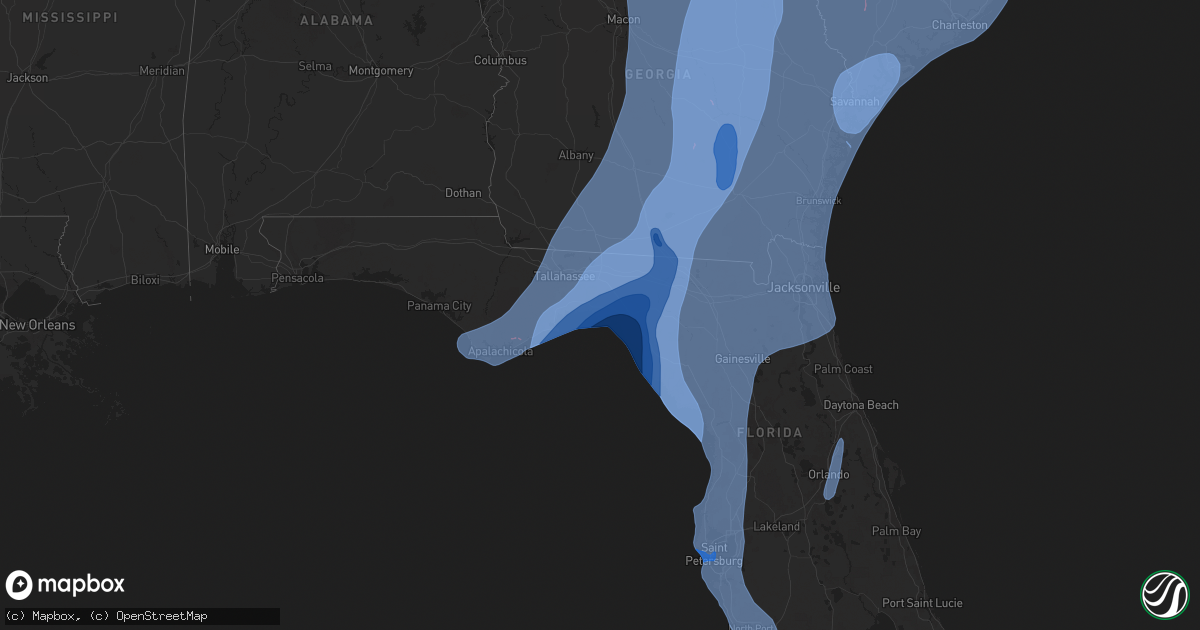
Hail Map on September 26, 2024
Get this storm
September 26 map
$229
one time, instant access
Download today. No call, no setup
Keep the $229
Bought the map and want the full workflow? Apply the entire $229 to a subscription within 7 days. None of it is wasted.
Every map, not just this one
This buys you this map. Subscription and you get every map we run, in the markets you choose from a few cities to whole states to nationwide. Plus real-time alerts the moment a storm fires.
Contact data
Name, contact info, occupancy, even credit band for addresses in the footprint. You go from where it hit to who to call.
Become the source they trust
Unlimited branding weather history reports on demand. You already have the documented answer ready for the property owner, and you are the one who showed up with it.
Property data and RoofTrace estimates
Pull up any address you have got, its value and the exact code rules for that jurisdiction, straight from One Click Code. Then RoofTrace estimates the squares, pitch, and roof value, priced the way you price.
States Impacted by Hail Map on September 26, 2024
Storm reports
Washington
| Date | Description |
|---|---|
| 09/26/20246:30 PM CDT | Several trees blown down on whitworth university. |
| 09/25/20248:30 PM CDT | Small metal roof ripped off a structure. |
Florida
| Date | Description |
|---|---|
| 09/26/20241:50 PM CDT | Report of a fallen tree. |
| 09/25/20248:00 PM CDT | Mesonet station 1695w fswn citystaug measured a wind gust of 59 mph. |
Georgia
| Date | Description |
|---|---|
| 09/26/20241:33 PM CDT | Tornado sighted on ground near hwy 268. No property damage observed or reported. |
| 09/26/20241:33 PM CDT | Update to previous tornado report from 2 ne broxton. Tornado sighted on ground near hwy 268e damaging shingles and shifting a double-wide trailer off its foundation at |
| 09/26/20242:38 AM CDT | Report from mping: trees uprooted or snapped;. |
| 09/25/20247:57 PM CDT | Corrects previous tornado report from adams cemetery road and highway 19. 2 fatalities confirmed in a mobile home destroyed by the tornado. |
| 09/25/20247:57 PM CDT | *** 2 inj *** tornado at adams cemetery road and highway 19. |
Kentucky
| Date | Description |
|---|---|
| 09/25/20247:58 PM CDT | Damage shown on social media at 125 and 1128 south southeast of hickman. Roof off a pole barn. |
South Carolina
| Date | Description |
|---|---|
| 09/26/202412:01 PM CDT | Emergency manager relayed report of trees down on bells highway near the bamberg county border. Possible tornado. |
| 09/26/202412:00 PM CDT | Tree down blocking both lanes on 22000 block of bells highway. Possible tornado. |
| 09/26/202411:58 AM CDT | Emergency manager relayed report of tree down at bells highway and woodrow drive. Possible tornado. |
| 09/26/202411:52 AM CDT | An ef-1 tornado with max winds around 90 mph touched down near gabriel road in colleton county... Sc and lifted just north of ehrhardt near baucham road in bamberg coun |
| 09/26/20245:04 AM CDT | Nws survey team verified an ef-0 tornado touched down near the intersection of columbus rd and stafford rd... With max winds of 65 mph. The tornado tracked nne... For 2 |
| 09/26/20243:20 AM CDT | An ef-0 tornado with max winds of 70 mph touched down near savannah highway and davidson road... Then moved northwest and lifted near bulow landing road. Path length wa |
| 09/26/20243:00 AM CDT | An ef-0 tornado with max winds of 80 mph touched down along bonanza rd near savannah hwy... Moved through parts of the boltons landing subdivision and lifted at saint h |
| 09/26/202412:29 AM CDT | An ef-0 tornado with max winds near 70 mph impacted the gardens corner area. The tornado began just southeast of washington farm road then traveled northwest across str |
| 09/25/202411:58 PM CDT | Dorchester county emergency management reported a tree down on highway 15 between grover and the edisto river. |
Virginia
| Date | Description |
|---|---|
| 09/26/20247:40 AM CDT | The smyth county 911 center reported that there was an apparent mudslide... Rockslide or landslide at the intersection of nicks creek road and pierce road in atkins. Se |
Cities Impacted by Hail Map on September 26, 2024
- Orangeburg, SC
- Neeses, SC
- Islandton, SC
- Lodge, SC
- Ehrhardt, SC
- Bamberg, SC
- Broxton, GA
- Alamo, GA
- Venice, FL
- North Port, FL
- Parrish, FL
- Bradenton, FL
- Myakka City, FL
- Sarasota, FL
- Nokomis, FL
- Punta Gorda, FL
- Fort Myers, FL
- Arcadia, FL
- Cape Coral, FL
- Fort Myers Beach, FL
- Bonita Springs, FL
- Rotonda West, FL
- Port Charlotte, FL
- Englewood, FL
- Placida, FL
- Osprey, FL
- Pinellas Park, FL
- Largo, FL
- Clearwater Beach, FL
- Wimauma, FL
- Belleair Beach, FL
- Palmetto, FL
- Ellenton, FL
- Seminole, FL
- Longboat Key, FL
- Anna Maria, FL
- Boca Grande, FL
- Terra Ceia, FL
- Indian Rocks Beach, FL
- Ruskin, FL
- Clearwater, FL
- Bradenton Beach, FL
- Dunedin, FL
- Saint Petersburg, FL
- Cortez, FL
- Sun City Center, FL
- Apollo Beach, FL
- Tampa, FL
- Palm Harbor, FL
- Safety Harbor, FL
- Oldsmar, FL
- Crystal Beach, FL
- Tarpon Springs, FL
- Holiday, FL
- New Port Richey, FL
- Odessa, FL
- Port Richey, FL
- Lutz, FL
- Land O'Lakes, FL
- Gibsonton, FL
- Riverview, FL
- Captiva, FL
- Bokeelia, FL
- Saint James City, FL
- Hudson, FL
- Spring Hill, FL
- Homosassa, FL
- Brooksville, FL
- Crystal River, FL
- Inglis, FL
- Yankeetown, FL
- Cedar Key, FL
- Chiefland, FL
- Horseshoe Beach, FL
- Old Town, FL
- Bronson, FL
- Trenton, FL
- Otter Creek, FL
- Cross City, FL
- Steinhatchee, FL
- Perry, FL
- Mayo, FL
- Salem, FL
- Lamont, FL
- Burlington, NC
- Branford, FL
- Bell, FL
- Dunnellon, FL
- Morriston, FL
- Beverly Hills, FL
- Lecanto, FL
- High Springs, FL
- O'Brien, FL
- McAlpin, FL
- Madison, FL
- Lee, FL
- Day, FL
- Live Oak, FL
- Greenville, FL
- Crawfordville, FL
- Midway, GA
- Hickman, KY
- Brandon, FL
- Thonotosassa, FL
- Seffner, FL
- Wesley Chapel, FL
- Inverness, FL
- San Antonio, FL
- Dade City, FL
- Hernando, FL
- Floral City, FL
- Holder, FL
- Archer, FL
- Newberry, FL
- Williston, FL
- Monticello, FL
- Tallahassee, FL
- Saint Marks, FL
- Sopchoppy, FL
- Hosford, FL
- Panacea, FL
- Carrabelle, FL
- Lanark Village, FL
- Eastpoint, FL
- Wewahitchka, FL
- Port Saint Joe, FL
- Apalachicola, FL
- Union City, TN
- Ocala, FL
- Gainesville, FL
- Reddick, FL
- Micanopy, FL
- Alachua, FL
- Fort White, FL
- Lake City, FL
- Wellborn, FL
- Bristol, FL
- Panama City, FL
- Telogia, FL
- Clarksville, FL
- Blountstown, FL
- Youngstown, FL
- Quincy, FL
- Altha, FL
- Havana, FL
- Lloyd, FL
- Midway, FL
- Jasper, FL
- White Springs, FL
- Pinetta, FL
- Jennings, FL
- Lynn Haven, FL
- Fountain, FL
- Gretna, FL
- Chattahoochee, FL
- Grand Ridge, FL
- Sneads, FL
- Marianna, FL
- Greensboro, FL
- Kissimmee, FL
- Orlando, FL
- Winter Springs, FL
- Winter Park, FL
- Oviedo, FL
- Sanford, FL
- Casselberry, FL
- Maitland, FL
- Longwood, FL
- Lake Mary, FL
- Deltona, FL
- Lake Butler, FL
- Lulu, FL
- Statenville, GA
- Climax, GA
- Lake Park, GA
- Cairo, GA
- Whigham, GA
- Quitman, GA
- Boston, GA
- Thomasville, GA
- Dixie, GA
- Valdosta, GA
- Brinson, GA
- Attapulgus, GA
- Bainbridge, GA
- Donalsonville, GA
- Ochlocknee, GA
- Glen Saint Mary, FL
- Hawthorne, FL
- Sanderson, FL
- Brooker, FL
- Du Pont, GA
- Fargo, GA
- Keystone Heights, FL
- Fleming Island, FL
- Middleburg, FL
- Green Cove Springs, FL
- Saint George, GA
- Saint Johns, FL
- Waldo, FL
- Earleton, FL
- Macclenny, FL
- Raiford, FL
- Lawtey, FL
- Hampton, FL
- Starke, FL
- Orange Park, FL
- Bryceville, FL
- Jacksonville, FL
- Ponte Vedra Beach, FL
- Atlantic Beach, FL
- Callahan, FL
- Neptune Beach, FL
- Jacksonville Beach, FL
- Yulee, FL
- Fernandina Beach, FL
- Sea Island, GA
- Saint Simons Island, GA
- Saint Marys, GA
- Jekyll Island, GA
- Kingsland, GA
- Kings Bay, GA
- Woodbine, GA
- Brunswick, GA
- Waverly, GA
- Hilliard, FL
- Lenox, GA
- Nicholls, GA
- Axson, GA
- Adel, GA
- Millwood, GA
- Moody Afb, GA
- Moultrie, GA
- Homerville, GA
- Morven, GA
- Sale City, GA
- Alma, GA
- Stockton, GA
- Lakeland, GA
- Ambrose, GA
- Omega, GA
- Hahira, GA
- Barney, GA
- Manor, GA
- Meigs, GA
- Tifton, GA
- Douglas, GA
- Pelham, GA
- Sumner, GA
- Waycross, GA
- Alapaha, GA
- Sparks, GA
- Coolidge, GA
- Pavo, GA
- Nashville, GA
- Camilla, GA
- Argyle, GA
- Barwick, GA
- Blackshear, GA
- Norman Park, GA
- Berlin, GA
- Pearson, GA
- Ray City, GA
- Doerun, GA
- Enigma, GA
- Funston, GA
- Naylor, GA
- Ellenton, GA
- Hartsfield, GA
- Willacoochee, GA
- Melrose, FL
- Saint Augustine, FL
- Sylvester, GA
- Wray, GA
- Jacksonville, GA
- Chula, GA
- Sycamore, GA
- Poulan, GA
- Fitzgerald, GA
- Ocilla, GA
- West Green, GA
- Rebecca, GA
- Ty Ty, GA
- Rhine, GA
- Abbeville, GA
- Pitts, GA
- Warwick, GA
- Baconton, GA
- Arabi, GA
- Rochelle, GA
- Vienna, GA
- Albany, GA
- Oakfield, GA
- Cordele, GA
- Ashburn, GA
- Eastman, GA
- Dudley, GA
- Cadwell, GA
- Riceboro, GA
- Townsend, GA
- Darien, GA
- Richmond Hill, GA
- Pineview, GA
- Hawkinsville, GA
- Dexter, GA
- Hazlehurst, GA
- Chauncey, GA
- Denton, GA
- Chester, GA
- Milan, GA
- Sapelo Island, GA
- Baxley, GA
- McRae Helena, GA
- Cochran, GA
- Lumber City, GA
- Unadilla, GA
- Bluffton, SC
- Tybee Island, GA
- Daufuskie Island, SC
- Ludowici, GA
- Hilton Head Island, SC
- Hardeeville, SC
- Port Wentworth, GA
- Fort Stewart, GA
- Bloomingdale, GA
- White Oak, GA
- Savannah, GA
- Ellabell, GA
- Fleming, GA
- Pooler, GA
- Citra, FL
- Mershon, GA
- Uvalda, GA
- Bristol, GA
- Surrency, GA
- Glenwood, GA
- Odum, GA
- Dublin, GA
- Rentz, GA
- Vidalia, GA
- Hoboken, GA
- Ailey, GA
- Glennville, GA
- Screven, GA
- Lyons, GA
- Patterson, GA
- Mount Vernon, GA
- Reidsville, GA
- Soperton, GA
- Tarrytown, GA
- Jesup, GA
- Collins, GA
- Claxton, GA
- Danville, GA
- Montrose, GA
- Rincon, GA
- Guyton, GA
- Ridgeland, SC
- Okatie, SC
- Hinesville, GA
- Saint Helena Island, SC
- Beaufort, SC
- Green Pond, SC
- Edisto Island, SC
- Wadmalaw Island, SC
- Port Royal, SC
- Johns Island, SC
- Seabrook, SC
- Sheldon, SC
- Swainsboro, GA
- McIntyre, GA
- Metter, GA
- Twin City, GA
- Adrian, GA
- Irwinton, GA
- Tennille, GA
- Cobbtown, GA
- Sandersville, GA
- Jeffersonville, GA
- Pulaski, GA
- Kite, GA
- Brooklet, GA
- East Dublin, GA
- Rockledge, GA
- Register, GA
- Toomsboro, GA
- Pembroke, GA
- Statesboro, GA
- Wrightsville, GA
- Garfield, GA
- Midville, GA
- Portal, GA
- Harrison, GA
- Tillman, SC
- Springfield, GA
- Bartow, GA
- Millen, GA
- Davisboro, GA
- Rocky Ford, GA
- Wadley, GA
- Gordon, GA
- Sylvania, GA
- Milledgeville, GA
- Louisville, GA
- Sparta, GA
- Warthen, GA
- Avera, GA
- Gibson, GA
- Waynesboro, GA
- Mitchell, GA
- Wrens, GA
- Perkins, GA
- Jewell, GA
- Hephzibah, GA
- Matthews, GA
- Girard, GA
- Stapleton, GA
- Keysville, GA
- Warrenton, GA
- Sardis, GA
- Dearing, GA
- Thomson, GA
- Blythe, GA
- Norwood, GA
- Camak, GA
- Harlem, GA
- Augusta, GA
- Grovetown, GA
- Beech Island, SC
- Jackson, SC
- Appling, GA
- Martin, SC
- Williston, SC
- Trenton, SC
- Ridge Spring, SC
- Warrenville, SC
- Clarks Hill, SC
- Graniteville, SC
- Evans, GA
- Windsor, SC
- New Ellenton, SC
- North Augusta, SC
- Gloverville, SC
- Aiken, SC
- Monetta, SC
- Crawfordville, GA
- Edgefield, SC
- Modoc, SC
- Lincolnton, GA
- Washington, GA
- Wagener, SC
- Batesburg, SC
- Salley, SC
- Pelion, SC
- Lexington, SC
- Gaston, SC
- Leesville, SC
- Swansea, SC
- Gilbert, SC
- Hopkins, SC
- Columbia, SC
- West Columbia, SC
- Plum Branch, SC
- Ward, SC
- Cayce, SC
- McCormick, SC
- Saluda, SC
- Johnston, SC
- Tignall, GA
- Troy, SC
- Mount Carmel, SC
- Calhoun Falls, SC
- Abbeville, SC
- Bradley, SC
- Elberton, GA
- Greenwood, SC
- Iva, SC
- Ninety Six, SC
- Chappells, SC
- Hodges, SC
- Prosperity, SC
- Lowndesville, SC
- Anderson, SC
- Due West, SC
- Honea Path, SC
- Starr, SC
- Donalds, SC
- Cross Hill, SC
- Waterloo, SC
- Mountville, SC
- Belton, SC
- Ware Shoals, SC
- Silverstreet, SC
- Newberry, SC
- Hartwell, GA
- Laurens, SC
- Little Mountain, SC
- Winnsboro, SC
- Pomaria, SC
- Clinton, SC
- Kinards, SC
- Chapin, SC
- Irmo, SC
- Blythewood, SC
- Jenkinsville, SC
- Joanna, SC
- Ridgeway, SC
- Blair, SC
- Whitmire, SC
- Elgin, SC
- Gray Court, SC
- Fair Play, SC
- Blackstock, SC
- Townville, SC
- Seneca, SC
- Carlisle, SC
- Simpsonville, SC
- Liberty, SC
- Chester, SC
- Mauldin, SC
- Williamston, SC
- Union, SC
- Pauline, SC
- Spartanburg, SC
- Jonesville, SC
- Piedmont, SC
- Buffalo, SC
- Enoree, SC
- Roebuck, SC
- Pelzer, SC
- Greer, SC
- Woodruff, SC
- Greenville, SC
- Moore, SC
- Fountain Inn, SC
- Pacolet, SC
- Pendleton, SC
- Gaffney, SC
- Glendale, SC
- Duncan, SC
- Central, SC
- Westminster, SC
- Easley, SC
- Startex, SC
- Lyman, SC
- Arcadia, SC
- Boiling Springs, SC
- Clemson, SC
- Chesnee, SC
- Cowpens, SC
- Wellford, SC
- Taylors, SC
- Una, SC
- Inman, SC
- Pickens, SC
- Walhalla, SC
- Marietta, SC
- Travelers Rest, SC
- West Union, SC
- Salem, SC
- Six Mile, SC
- Norris, SC
- Sunset, SC
- Mountain Rest, SC
- Long Creek, SC
- Tamassee, SC
- Gresham, SC
- Slater, SC
- Cleveland, SC
- Landrum, SC
- Campobello, SC
- Yemassee, SC
- Mullins, SC
- Fork, SC
- Lake View, SC
- Fairmont, NC
- Dillon, SC
- Conway, SC
- Southport, NC
- Mill Spring, NC
- Tryon, NC
- Saluda, NC
- Columbus, NC
- Zirconia, NC
- Rutherfordton, NC
- Candler, NC
- Penrose, NC
- East Flat Rock, NC
- Morganton, NC
- Horse Shoe, NC
- Alexander, NC
- Wilkesboro, NC
- Newland, NC
- Green Mountain, NC
- Cedar Mountain, NC
- Lake Toxaway, NC
- Brevard, NC
- Purlear, NC
- McGrady, NC
- Clyde, NC
- Marion, NC
- Hendersonville, NC
- Fairview, NC
- Asheville, NC
- Flat Rock, NC
- Hays, NC
- Tuckasegee, NC
- Gerton, NC
- Glenville, NC
- Bakersville, NC
- Deep Gap, NC
- Clayton, GA
- Cashiers, NC
- Nebo, NC
- Barnardsville, NC
- Union Mills, NC
- Canton, NC
- Swannanoa, NC
- Lenoir, NC
- Old Fort, NC
- North Wilkesboro, NC
- Highlands, NC
- Fletcher, NC
- Etowah, NC
- Pisgah Forest, NC
- Arden, NC
- Burnsville, NC
- Rosman, NC
- Ferguson, NC
- Weaverville, NC
- Black Mountain, NC
- Boone, NC
- Banner Elk, NC
- Cullowhee, NC
- Spruce Pine, NC
- Traphill, NC
- Lake Lure, NC
- Hot Springs, NC
- Linville, NC
- Millers Creek, NC
- Leicester, NC
- Mills River, NC
- Marshall, NC
- Collettsville, NC
- Waynesville, NC
- Blowing Rock, NC
- Balsam Grove, NC
- Sapphire, NC
- Mars Hill, NC
- Mosheim, TN
- Vilas, NC
- Russellville, TN
- Crumpler, NC
- Sugar Grove, NC
- Zionville, NC
- Mooresburg, TN
- Midway, TN
- Laurel Springs, NC
- Elk Creek, VA
- Roan Mountain, TN
- Lake Junaluska, NC
- Greeneville, TN
- Max Meadows, VA
- Bybee, TN
- Cherokee, NC
- Jefferson, NC
- Bean Station, TN
- Fleetwood, NC
- Morristown, TN
- Roaring Gap, NC
- Whittier, NC
- Woodlawn, VA
- Otto, NC
- Sparta, NC
- Hiwassee, VA
- Butler, TN
- Galax, VA
- Lansing, NC
- Austinville, VA
- Rabun Gap, GA
- Independence, VA
- Gatlinburg, TN
- Dillard, GA
- Sevierville, TN
- Scottville, NC
- Dandridge, TN
- Balsam, NC
- White Pine, TN
- Creston, NC
- Newport, TN
- Piney Creek, NC
- Mouth Of Wilson, VA
- Warrensville, NC
- Parrottsville, TN
- Flag Pond, TN
- Elk Park, NC
- Del Rio, TN
- Hartford, TN
- Todd, NC
- Fries, VA
- Glendale Springs, NC
- Mohawk, TN
- Sylva, NC
- Cosby, TN
- Glade Valley, NC
- West Jefferson, NC
- Scaly Mountain, NC
- Hillsville, VA
- Franklin, NC
- Trade, TN
- Maggie Valley, NC
- Ennice, NC
- Grassy Creek, NC
- Elizabethton, TN
- Fall Branch, TN
- Johnson City, TN
- Jonesborough, TN
- Bulls Gap, TN
- Mount Carmel, TN
- Chilhowie, VA
- Afton, TN
- Rogersville, TN
- Mountain City, TN
- Damascus, VA
- Bristol, TN
- Barren Springs, VA
- Thorn Hill, TN
- Telford, TN
- Troutdale, VA
- Erwin, TN
- Bluff City, TN
- Talbott, TN
- Speedwell, VA
- Abingdon, VA
- Meadowview, VA
- Rural Retreat, VA
- Unicoi, TN
- Blountville, TN
- Hampton, TN
- Limestone, TN
- Cripple Creek, VA
- Whitesburg, TN
- Laurel Bloomery, TN
- Chuckey, TN
- Shady Valley, TN
- Watauga, TN
- Glade Spring, VA
- Sugar Grove, VA
- Bristol, VA
- Surgoinsville, TN
- Whitetop, VA
- Ivanhoe, VA
- Wytheville, VA
- Kingsport, TN
- Piney Flats, TN
- Marion, VA
- Church Hill, TN
- Bryson City, NC
- Hiltons, VA
- Sneedville, TN
- Eidson, TN
- Crockett, VA
- Gate City, VA
- Lowgap, NC
- Folkston, GA
- Newington, GA
- Waynesville, GA
- Hortense, GA
- Nahunta, GA
- Allenhurst, GA
- Coosawhatchie, SC
- Ridgeville, SC
- Clyo, GA
- Bonneau, SC
- Round O, SC
- Isle Of Palms, SC
- Hollywood, SC
- Cottageville, SC
- Walterboro, SC
- Folly Beach, SC
- Summerville, SC
- Early Branch, SC
- Adams Run, SC
- Eutawville, SC
- Georgetown, SC
- Pinopolis, SC
- Cross, SC
- Saint Stephen, SC
- Reevesville, SC
- Ravenel, SC
- North Charleston, SC
- Saint George, SC
- Dorchester, SC
- Vance, SC
- Ladson, SC
- Huger, SC
- Sullivans Island, SC
- Holly Hill, SC
- Santee, SC
- Jamestown, SC
- Harleyville, SC
- Cordesville, SC
- Smoaks, SC
- Mount Pleasant, SC
- Moncks Corner, SC
- Pineland, SC
- Charleston Afb, SC
- Hanahan, SC
- Charleston, SC
- Goose Creek, SC
- Bowman, SC
- Andrews, SC
- Jacksonboro, SC
- Branchville, SC
- Varnville, SC
- McClellanville, SC
- Awendaw, SC
- Ruffin, SC
- Olar, SC
- Cameron, SC
- Denmark, SC
- Blackville, SC
- Fairfax, SC
- Garnett, SC
- Hampton, SC
- Barnwell, SC
- Norway, SC
- Cope, SC
- Brunson, SC
- Luray, SC
- Rowesville, SC
- Cordova, SC
- Allendale, SC
- Ulmer, SC
- Estill, SC
- Elloree, SC
- Williams, SC
- North, SC
- Eastover, SC
- Gadsden, SC
- Saint Matthews, SC
- Springfield, SC
- Pineville, SC
- Fancy Gap, VA
- Dobson, NC
- Pikeville, KY
- Mouthcard, KY
- Broadford, VA
- Rock, WV
- Bluefield, WV
- Lebanon, VA
- Oakwood, VA
- Tazewell, VA
- Logan, WV
- Switzer, WV
- Lashmeet, WV
- Sarah Ann, WV
- Omar, WV
- Squire, WV
- Haysi, VA
- Williamson, WV
- Honaker, VA
- Elbert, WV
- Matheny, WV
- Mendota, VA
- Hellier, KY
- Coal Mountain, WV
- Elkhorn City, KY
- Lake, WV
- Hewett, WV
- Clothier, WV
- Matewan, WV
- Shelby Gap, KY
- Cedar Bluff, VA
- Bee, VA
- Davenport, VA
- Fedscreek, KY
- Wharton, WV
- Rosedale, VA
- Simon, WV
- Switchback, WV
- Saltville, VA
- Narrows, VA
- Pilgrims Knob, VA
- Pound, VA
- North Tazewell, VA
- Richlands, VA
- Kyle, WV
- Castlewood, VA
- Pecks Mill, WV
- Jolo, WV
- Princeton, WV
- Amherstdale, WV
- Nickelsville, VA
- Whitewood, VA
- Jesse, WV
- Bim, WV
- Bramwell, WV
- Man, WV
- Hardy, KY
- Saulsville, WV
- Fanrock, WV
- Lick Creek, KY
- Hanover, WV
- Mullens, WV
- Maybeury, WV
- Elkhorn, WV
- Bland, VA
- Bastian, VA
- Weber City, VA
- Tannersville, VA
- Ashcamp, KY
- Davy, WV
- Kyles Ford, TN
- Pennington Gap, VA
- Phyllis, KY
- Dugspur, VA
- Big Rock, VA
- Falls Mills, VA
- Ikes Fork, WV
- Pocahontas, VA
- Baisden, WV
- Iaeger, WV
- Draper, VA
- Welch, WV
- Ravencliff, WV
- Blackwater, VA
- Mohawk, WV
- Kimper, KY
- Dante, VA
- Spanishburg, WV
- Bluefield, VA
- Clinchco, VA
- Yolyn, WV
- Big Stone Gap, VA
- Pulaski, VA
- Cleveland, VA
- Raysal, WV
- Pounding Mill, VA
- War, WV
- Birchleaf, VA
- Itmann, WV
- Breaks, VA
- Dryden, VA
- Chauncey, WV
- Atkins, VA
- Majestic, KY
- Wharncliffe, WV
- McAndrews, KY
- McCarr, KY
- Anawalt, WV
- Stephenson, WV
- Kegley, WV
- Jewell Ridge, VA
- Wise, VA
- Stollings, WV
- Hurley, VA
- Beeson, WV
- Freeburn, KY
- Stopover, KY
- Swords Creek, VA
- Freeman, WV
- Regina, KY
- Jonesville, VA
- Verner, WV
- Pineville, WV
- Kimball, WV
- Belcher, KY
- Davin, WV
- Delbarton, WV
- Saint Paul, VA
- Northfork, WV
- Panther, WV
- McClure, VA
- Ransom, KY
- Cyclone, WV
- Montcalm, WV
- Clear Fork, WV
- Berwind, WV
- Lyburn, WV
- Bandy, VA
- New Richmond, WV
- Dublin, VA
- Raven, VA
- Norton, VA
- Matoaka, WV
- Oceana, WV
- Paynesville, WV
- Vansant, VA
- Fort Blackmore, VA
- Wyoming, WV
- Pinsonfork, KY
- Mallory, WV
- Gilbert, WV
- North Spring, WV
- Clintwood, VA
- Steele, KY
- Coeburn, VA
- Duffield, VA
- Amigo, WV
- Rowe, VA
- Pearisburg, VA
- Phelps, KY
- Appalachia, VA
- Glen Fork, WV
- Brenton, WV
- Grundy, VA
- Nora, VA
- Dungannon, VA
- Rocky Gap, VA
- Ceres, VA
- Herndon, WV
- Odd, WV
- Holden, WV
- Keokee, VA
- Belfry, KY
- Raccoon, KY
- Jenkins, KY
- Eolia, KY
- Chapmanville, WV
- Henlawson, WV
- Canada, KY
- Shelbiana, KY
- Stone, KY
- Huddy, KY
- Partridge, KY
- Seco, KY
- Dingess, WV
- Whitesburg, KY
- Lovely, KY
- Forest Hills, KY
- Lynch, KY
- Robinson Creek, KY
- Jackhorn, KY
- Holmes Mill, KY
- Breeden, WV
- Benham, KY
- Neon, KY
- Varney, KY
- Kermit, WV
- South Williamson, KY
- Virgie, KY
- Lenore, WV
- Millstone, KY
- Beaver, KY
- Thornton, KY
- Deane, KY
- McRoberts, KY
- Harts, WV
- Sidney, KY
- Mayking, KY
- Pilgrim, KY
- Ermine, KY
- Harold, KY
- McDowell, KY
- Isom, KY
- Melvin, KY
- Bevinsville, KY
- Weeksbury, KY
- Teaberry, KY
- Grethel, KY
- Topmost, KY
- Hi Hat, KY
- Wheelwright, KY
- Bypro, KY
- Kite, KY
- Cumberland, KY
- Dunlow, WV
- Crum, WV
- Betsy Layne, KY
- Martin, KY
- Printer, KY
- Minnie, KY
- Inez, KY
- Wayland, KY
- Tram, KY
- Beauty, KY
- Tomahawk, KY
- Prestonsburg, KY
- Drift, KY
- Warfield, KY
- Fort Gay, WV
- Boons Camp, KY
- Louisa, KY
- Langley, KY
- Kiahsville, WV
- Dwale, KY
- Ivel, KY
- Allen, KY
- Wilsondale, WV
- Raven, KY
- Van Lear, KY
- Lackey, KY
- Debord, KY
- Stanville, KY
- Dema, KY
- Dana, KY
- Banner, KY
- Eastern, KY
- Lowmansville, KY
- Thelma, KY
- Staffordsville, KY
- Pine Top, KY
- Salyersville, KY
- Hagerhill, KY
- Hueysville, KY
- Paintsville, KY
- Genoa, WV
- Mousie, KY
- Blue River, KY
- Blaine, KY
- Martha, KY
- Oil Springs, KY
- Garrett, KY
- Keaton, KY
- Gunlock, KY
- Auxier, KY
- West Van Lear, KY
- Sitka, KY
- Isonville, KY
- Adams, KY
- East Point, KY
- David, KY
- Stambaugh, KY
- Wittensville, KY
- Pippa Passes, KY
- Sandy Hook, KY
- Royalton, KY
- West Liberty, KY
- Tutor Key, KY
- Ulysses, KY
- Meally, KY
- River, KY
- Flatgap, KY
- Williamsport, KY
- Wellington, KY
- Zoe, KY
- Garner, KY
- Whick, KY
- Vancleve, KY
- Lost Creek, KY
- Littcarr, KY
- Bulan, KY
- Ary, KY
- Carrie, KY
- Emmalena, KY
- Clayhole, KY
- Hazel Green, KY
- Slade, KY
- Leburn, KY
- Mallie, KY
- Elkfork, KY
- Hindman, KY
- Hazard, KY
- Rogers, KY
- Booneville, KY
- Vest, KY
- Frenchburg, KY
- Bays, KY
- Rowdy, KY
- Ezel, KY
- Mize, KY
- Denniston, KY
- Rousseau, KY
- Campton, KY
- Cannel City, KY
- Stanton, KY
- Pine Ridge, KY
- Chavies, KY
- Jackson, KY
- Beattyville, KY
- Linefork, KY
- Cornettsville, KY
- Smilax, KY
- Slemp, KY
- Scuddy, KY
- Totz, KY
- Yeaddiss, KY
- Jeff, KY
- Dwarf, KY
- Viper, KY
- Ricetown, KY
- Premium, KY
- Hallie, KY
- Jeremiah, KY
- Sassafras, KY
- Bonnyman, KY
- Happy, KY
- Buckhorn, KY
- Letcher, KY
- Roxana, KY
- Gordon, KY
- Wooton, KY
- Gays Creek, KY
- Hyden, KY
- Krypton, KY
- Busy, KY
- Blackey, KY
- Redfox, KY
- Combs, KY
- Delphia, KY
- Vicco, KY
- Closplint, KY
- Saint Charles, VA
- Evarts, KY
- Haddock, GA
- Kathleen, GA
- Bonaire, GA
- Dry Branch, GA
- Macon, GA
- Warner Robins, GA
- White Plains, GA
- Bogart, GA
- Baldwin, GA
- Arnoldsville, GA
- Canon, GA
- Royston, GA
- Winterville, GA
- Bowman, GA
- Bishop, GA
- Homer, GA
- Commerce, GA
- Carnesville, GA
- Lakemont, GA
- Union Point, GA
- Newborn, GA
- Tiger, GA
- Good Hope, GA
- Toccoa, GA
- Martin, GA
- Lavonia, GA
- Carlton, GA
- Shady Dale, GA
- Stephens, GA
- Clarkesville, GA
- Hull, GA
- Greensboro, GA
- Rutledge, GA
- Bowersville, GA
- Eastanollee, GA
- Colbert, GA
- Madison, GA
- Rayle, GA
- Crawford, GA
- Hillsboro, GA
- Lexington, GA
- Gray, GA
- Eatonton, GA
- Watkinsville, GA
- Comer, GA
- Danielsville, GA
- Buckhead, GA
- Dewy Rose, GA
- Monticello, GA
- Nicholson, GA
- Athens, GA
- Chappell, KY
- Ages Brookside, KY
- Kenvir, KY
- Bledsoe, KY
- Big Laurel, KY
- Putney, KY
- Baxter, KY
- Wendover, KY
- Thousandsticks, KY
- Cawood, KY
- Cranks, KY
- Mozelle, KY
- Big Creek, WV
- New Tazewell, TN
- Stanford, KY
- Washburn, TN
- Flat Lick, KY
- Clay City, KY
- Jefferson City, TN
- Green Road, KY
- Mascot, TN
- Helton, KY
- Richmond, KY
- Cumberland Gap, TN
- Oneida, KY
- Artemus, KY
- Middlesboro, KY
- Pathfork, KY
- Frakes, KY
- Millersburg, KY
- Burgin, KY
- Georgetown, KY
- Scalf, KY
- Sharpsburg, KY
- Rose Hill, VA
- Beverly, KY
- Webbville, KY
- Speedwell, TN
- Versailles, KY
- Tyner, KY
- Grayson, KY
- Owenton, KY
- Stinnett, KY
- Strawberry Plains, TN
- Cynthiana, KY
- Coalgood, KY
- Tazewell, TN
- Jeffersonville, KY
- Livingston, KY
- Grays Knob, KY
- Bimble, KY
- Hillsboro, KY
- Maynardville, TN
- Lancaster, KY
- Means, KY
- Moorefield, KY
- Manchester, KY
- Denton, KY
- Danville, KY
- Clearfield, KY
- Sadieville, KY
- Roark, KY
- Wilmore, KY
- Mount Sterling, KY
- Girdler, KY
- Calvin, KY
- Hope, KY
- Harrogate, TN
- Warbranch, KY
- Powder Springs, TN
- Sandgap, KY
- Mount Vernon, KY
- Hulen, KY
- Wayne, WV
- Bear Branch, KY
- Fourmile, KY
- Lexington, KY
- Midway, KY
- Big Creek, KY
- Ranger, WV
- Catlettsburg, KY
- Lily, KY
- Arjay, KY
- Waco, KY
- Gulston, KY
- Corbin, KY
- Rockholds, KY
- Nicholasville, KY
- Dayhoit, KY
- Woodbine, KY
- Crab Orchard, KY
- Owingsville, KY
- Sizerock, KY
- Ewing, VA
- Prichard, WV
- East Bernstadt, KY
- Cannon, KY
- Miracle, KY
- Rush, KY
- Siler, KY
- Pigeon Forge, TN
- Ewing, KY
- Mary Alice, KY
- Olympia, KY
- Essie, KY
- Wallingford, KY
- Heidrick, KY
- Harlan, KY
- Barbourville, KY
- North Middletown, KY
- Lawrenceburg, KY
- Rutledge, TN
- Walker, KY
- Loyall, KY
- Paris, KY
- Frankfort, KY
- Kodak, TN
- Salvisa, KY
- New Market, TN
- Wallins Creek, KY
- Ravenna, KY
- Carlisle, KY
- Pineville, KY
- Stoney Fork, KY
- Salt Lick, KY
- Bryants Store, KY
- East Lynn, WV
- Sextons Creek, KY
- Luttrell, TN
- Orlando, KY
- Hitchins, KY
- Trosper, KY
- Vanceburg, KY
- Flemingsburg, KY
- Mistletoe, KY
- Vincent, KY
- Brodhead, KY
- Blaine, TN
- Hinkle, KY
- London, KY
- Irvine, KY
- Berea, KY
- Gray, KY
- Paint Lick, KY
- McKee, KY
- Coldiron, KY
- Emerson, KY
- Annville, KY
- Harrodsburg, KY
- Olive Hill, KY
- Kettle Island, KY
- Stamping Ground, KY
- Keavy, KY
- Morehead, KY
- Winchester, KY
- Mount Airy, GA
- Jefferson, GA
- Sharps Chapel, TN
- Williamsburg, KY
- Clairfield, TN
- Grover, NC
- Hickory, NC
- Kings Mountain, NC
- Cherryville, NC
- Forest City, NC
- Vale, NC
- Smyrna, SC
- Clover, SC
- Shelby, NC
- McConnells, SC
- Drexel, NC
- Connelly Springs, NC
- Sharon, SC
- Hickory Grove, SC
- Lawndale, NC
- Valdese, NC
- York, SC
- Granite Falls, NC
- Lockhart, SC
- Mooresboro, NC
- Spindale, NC
- Casar, NC
- Bostic, NC
- Blacksburg, SC
- Mayo, SC
- Ellenboro, NC
- Elkin, NC
- Lambsburg, VA
- Hiddenite, NC
- Iron Station, NC
- Troutman, NC
- Pineville, NC
- Huntersville, NC
- Thurmond, NC
- Dallas, NC
- Great Falls, SC
- Yadkinville, NC
- Lincolnton, NC
- Conover, NC
- Union Grove, NC
- Edgemoor, SC
- Maiden, NC
- Mount Airy, NC
- Alexis, NC
- Belmont, NC
- State Road, NC
- Moravian Falls, NC
- Olin, NC
- Hudson, NC
- Stanley, NC
- Mooresville, NC
- Terrell, NC
- Richburg, SC
- Boomer, NC
- Ronda, NC
- Claremont, NC
- Catawba, SC
- Davidson, NC
- Fort Lawn, SC
- McAdenville, NC
- Newton, NC
- Roaring River, NC
- Stony Point, NC
- Lowell, NC
- Charlotte, NC
- Fort Mill, SC
- Denver, NC
- Statesville, NC
- Mount Holly, NC
- Crouse, NC
- Hildebran, NC
- Cramerton, NC
- Hamptonville, NC
- Harmony, NC
- Sherrills Ford, NC
- Boonville, NC
- Catawba, NC
- Rock Hill, SC
- Jonesville, NC
- Taylorsville, NC
- Bessemer City, NC
- Gastonia, NC
- Cornelius, NC
- Cana, VA
- East Bend, NC
- Landis, NC
- Waxhaw, NC
- Matthews, NC
- Ararat, VA
- Monroe, NC
- Heath Springs, SC
- Mocksville, NC
- Salisbury, NC
- Ararat, NC
- Siloam, NC
- Woodleaf, NC
- Harrisburg, NC
- Indian Trail, NC
- China Grove, NC
- Kannapolis, NC
- Mount Ulla, NC
- Cleveland, NC
- Lancaster, SC
- Concord, NC
- Pendergrass, GA
- Statham, GA
- Alto, GA
- Clermont, GA
- Warne, NC
- Helen, GA
- Marble, NC
- Braselton, GA
- Murphy, NC
- Winder, GA
- Brasstown, NC
- Murrayville, GA
- Suches, GA
- Lula, GA
- Hiawassee, GA
- Maysville, GA
- Cornelia, GA
- Gillsville, GA
- Talmo, GA
- Gainesville, GA
- Sautee Nacoochee, GA
- Monroe, GA
- Hoschton, GA
- Young Harris, GA
- Cleveland, GA
- Demorest, GA
- Andrews, NC
- Hayesville, NC
- Dahlonega, GA
- Social Circle, GA
- Blairsville, GA
- Topton, NC
- Fontana Dam, NC
- Robbinsville, NC
- Almond, NC
- Seymour, TN
- Rocky Mount, NC
- Florahome, FL
- Palatka, FL
- Mayslick, KY
- Berry, KY
- Maysville, KY
- Ponte Vedra, FL
- Germantown, KY
- Tollesboro, KY
- Corinth, KY
- Mount Olivet, KY
- Garland, NC
- Pedro, OH
- Chesapeake, OH
- Crown City, OH
- South Point, OH
- Kitts Hill, OH
- Ashland, KY
- Barboursville, WV
- Willow Wood, OH
- Scottown, OH
- Proctorville, OH
- Lavalette, WV
- South Webster, OH
- Ona, WV
- Lesage, WV
- Ironton, OH
- Russell, KY
- Patriot, OH
- Huntington, WV
- Gallipolis, OH
- Waterloo, OH
- Salt Rock, WV
- Branchland, WV
- Oak Hill, OH
- Ceredo, WV
- Wheelersburg, OH
- Argillite, KY
- Kenova, WV
- Franklin Furnace, OH
- Jackson, OH
- Lucasville, OH
- Beaver, OH
- Portsmouth, OH
- Minford, OH
- New Vienna, OH
- Waynesville, OH
- Leesburg, OH
- Hillsboro, OH
- Midland, OH
- Clarksville, OH
- Lebanon, OH
- Sabina, OH
- Wilmington, OH
- Morrow, OH
- Oregonia, OH
- Blanchester, OH
- Martinsville, OH
- Lynchburg, OH
- Flatwoods, KY
- Greenup, KY
- Worthington, KY
- Port William, OH
- Jamestown, OH
- Xenia, OH
- Harveysburg, OH
- Wellston, OH
- Rio Grande, OH
- Vinton, OH
- Thurman, OH
- Bidwell, OH
- Coalton, OH
- Chillicothe, OH
- Waverly, OH
- Ray, OH
- Alexandria, KY
- Dover, KY
- Williamstown, KY
- De Mossville, KY
- Melbourne, KY
- Manchester, OH
- Brooksville, KY
- Augusta, KY
- Moscow, OH
- New Richmond, OH
- Foster, KY
- Bethel, OH
- Georgetown, OH
- Butler, KY
- Falmouth, KY
- Newport, KY
- Neville, OH
- Aberdeen, OH
- California, KY
- Felicity, OH
- West Portsmouth, OH
- Friendship, OH
- McDermott, OH
- South Shore, KY
- Stout, OH
- South Portsmouth, KY
- Quincy, KY
- Garrison, KY
- Batavia, OH
- Silver Grove, KY
- Sardinia, OH
- Amelia, OH
- Otway, OH
- Piketon, OH
- Seaman, OH
- Williamsburg, OH
- Peebles, OH
- West Union, OH
- Mount Orab, OH
- Blue Creek, OH
- Ripley, OH
- Russellville, OH
- Lynx, OH
- Latham, OH
- Hamersville, OH
- Rarden, OH
- Winchester, OH
- Cincinnati, OH
- Washington Court House, OH
- Maineville, OH
- Camp Dennison, OH
- Loveland, OH
- Owensville, OH
- Frankfort, OH
- Richmond Dale, OH
- Pleasant Plain, OH
- Bainbridge, OH
- South Lebanon, OH
- South Salem, OH
- Goshen, OH
- Fayetteville, OH
- Milford, OH
- Fort Thomas, KY
- Terrace Park, OH
- Greenfield, OH
- Miamiville, OH
- Kings Mills, OH
- Londonderry, OH
- Springboro, OH
- Eaton, OH
- Dayton, KY
- Middletown, OH
- West Chester, OH
- Spring Valley, OH
- Farmersville, OH
- Bellevue, KY
- Bellbrook, OH
- Miamisburg, OH
- New Lebanon, OH
- Franklin, OH
- Somerville, OH
- Monroe, OH
- West Alexandria, OH
- Mason, OH
- Germantown, OH
- Seven Mile, OH
- Hamilton, OH
- Trenton, OH
- Fairfield, OH
- Dayton, OH
- Camden, OH
- Ft Mitchell, KY
- Cleves, OH
- Hooven, OH
- Florence, KY
- Harrison, OH
- Miamitown, OH
- North Bend, OH
- Okeana, OH
- Latonia, KY
- Erlanger, KY
- Hebron, KY
- Burlington, KY
- Addyston, OH
- Covington, KY
- Oxford, OH
- Morning View, KY
- Independence, KY
- Walton, KY
- Boston, IN
- Westport, IN
- Richmond, IN
- Waldron, IN
- West Harrison, IN
- Monrovia, IN
- Hartsville, IN
- Milton, IN
- Batesville, IN
- Charlottesville, IN
- Centerville, IN
- Moores Hill, IN
- Liberty, IN
- Milroy, IN
- Oldenburg, IN
- Cambridge City, IN
- Columbus, IN
- Milan, IN
- Shelbyville, IN
- Osgood, IN
- Nashville, IN
- Greenwood, IN
- Morgantown, IN
- Carthage, IN
- Franklin, IN
- Bath, IN
- New Palestine, IN
- Rushville, IN
- Nineveh, IN
- Napoleon, IN
- Brookville, IN
- Greensburg, IN
- Fountaintown, IN
- Coatesville, IN
- Falmouth, IN
- Fairland, IN
- Beech Grove, IN
- College Corner, OH
- West College Corner, IN
- Clayton, IN
- Saint Paul, IN
- Homer, IN
- Stilesville, IN
- Boggstown, IN
- Morristown, IN
- Gwynneville, IN
- Brownsville, IN
- Needham, IN
- Martinsville, IN
- Trafalgar, IN
- Laurel, IN
- Indianapolis, IN
- Whiteland, IN
- Mooresville, IN
- New Trenton, IN
- Amo, IN
- Taylorsville, IN
- Mays, IN
- Connersville, IN
- Arlington, IN
- Clifford, IN
- Lewisville, IN
- Hope, IN
- Greenfield, IN
- Flat Rock, IN
- Edinburgh, IN
- Straughn, IN
- Knightstown, IN
- Plainfield, IN
- Camby, IN
- Petersburg, KY
- Manilla, IN
- Metamora, IN
- Glenwood, IN
- Brooklyn, IN
- Cedar Grove, IN
- Danville, IN
- Aurora, IN
- Guilford, IN
- Avon, IN
- Spiceland, IN
- Bargersville, IN
- Lawrenceburg, IN
- West Newton, IN
- Sunman, IN
- Union, KY
- Holton, IN
- Butlerville, IN
- North Vernon, IN
- Elizabethtown, IN
- Shirley, IN
- Wilkinson, IN
- New Castle, IN
- Mccordsville, IN
- Maxwell, IN
- Fortville, IN
- Rockbridge, OH