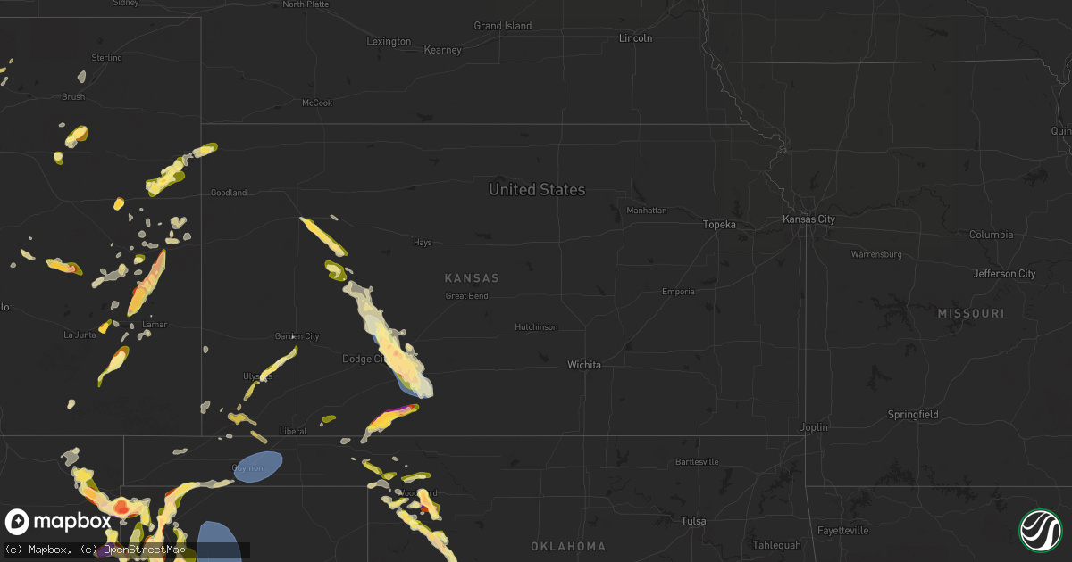
Hail Map in Kansas on May 28, 2024
Get this storm
May 28 map
$229
one time, instant access
Download today. No call, no setup
Keep the $229
Bought the map and want the full workflow? Apply the entire $229 to a subscription within 7 days. None of it is wasted.
Every map, not just this one
This buys you this map. Subscription and you get every map we run, in the markets you choose from a few cities to whole states to nationwide. Plus real-time alerts the moment a storm fires.
Contact data
Name, contact info, occupancy, even credit band for addresses in the footprint. You go from where it hit to who to call.
Become the source they trust
Unlimited branding weather history reports on demand. You already have the documented answer ready for the property owner, and you are the one who showed up with it.
Property data and RoofTrace estimates
Pull up any address you have got, its value and the exact code rules for that jurisdiction, straight from One Click Code. Then RoofTrace estimates the squares, pitch, and roof value, priced the way you price.
Storm reports in Kansas
Kansas
| Date | Description |
|---|---|
| 05/28/20244:35 PM CDT | A local report indicates 1.00 inch wind near 3 E Mullinville |
| 05/28/20244:30 PM CDT | A local report indicates 1.00 inch wind near Mullinville |
| 05/28/20244:27 PM CDT | A local report indicates 1.00 inch wind near Mullinville |
| 05/28/20243:56 PM CDT | A local report indicates 2.00 inch wind near 3 S Bellefont |
| 05/28/20243:50 PM CDT | A local report indicates 1.50 inch wind near Spearville |
| 05/28/20243:50 PM CDT | A local report indicates 1.75 inch wind near Spearville |
| 05/28/20243:14 PM CDT | A local report indicates 60 MPH wind near Jetmore |
| 05/28/20241:40 PM CDT | A local report indicates 1.00 inch wind near 1 NW Shields |
| 05/28/202412:40 PM CDT | Hail lasted for 15-20 minutes. Estimated time of report from radar. |
| 05/28/202412:11 PM CDT | Some hail may have been as large as golf ball in size. |
| 05/28/202411:20 AM CDT | A local report indicates 1.75 inch wind near Ashland |
| 05/28/202411:19 AM CDT | A local report indicates 2.00 inch wind near Ashland |
| 05/28/202411:19 AM CDT | A local report indicates 2.50 inch wind near Ashland |
| 05/28/202411:15 AM CDT | A local report indicates 2.50 inch wind near Ashland |
| 05/28/202410:15 AM CDT | A local report indicates 1.00 inch wind near 4 W Meade State Park |
| 05/27/20248:00 PM CDT | Quarters to half dollar size hail was reported. |
| 05/27/20247:45 PM CDT | Dimes to nickels mostly... With a few quarter size hailstones were reported. |
| 05/27/20247:23 PM CDT | Social media photo. |
All States Impacted by Hail Map on May 28, 2024
Cities Impacted by Hail Map on May 28, 2024
- Barnesville, PA
- Ennis, TX
- Chatfield, TX
- Kemp, TX
- Rice, TX
- Mabank, TX
- Terrell, TX
- Kaufman, TX
- Scurry, TX
- Elida, NM
- Sudan, TX
- Wildorado, TX
- Vega, TX
- Jacksboro, TX
- Olney, TX
- Loving, TX
- Canton, TX
- Wills Point, TX
- Corsicana, TX
- Kerens, TX
- Powell, TX
- Bryson, TX
- Jermyn, TX
- Graham, TX
- Athens, TX
- Trinidad, TX
- Eustace, TX
- Malakoff, TX
- Ben Wheeler, TX
- Van, TX
- Muleshoe, TX
- Lindale, TX
- Brownsboro, TX
- Murchison, TX
- Tyler, TX
- Frankston, TX
- Montalba, TX
- Palestine, TX
- Larue, TX
- Chandler, TX
- Emory, TX
- Newcastle, TX
- Newark, TX
- Azle, TX
- Boyd, TX
- Fort Worth, TX
- Flint, TX
- Bullard, TX
- Poolville, TX
- Weatherford, TX
- Jacksonville, TX
- Haltom City, TX
- Mineola, TX
- Troup, TX
- Whitehouse, TX
- Kennedale, TX
- Arlington, TX
- Granbury, TX
- Mansfield, TX
- Crowley, TX
- Arp, TX
- Winona, TX
- Overton, TX
- Price, TX
- Henderson, TX
- Kilgore, TX
- Selman City, TX
- Godley, TX
- Cleburne, TX
- Nemo, TX
- Rio Vista, TX
- Blum, TX
- Grand Prairie, TX
- Midlothian, TX
- Cedar Hill, TX
- Rusk, TX
- Grandview, TX
- Covington, TX
- Laneville, TX
- Itasca, TX
- Fort Supply, OK
- Reklaw, TX
- Follett, TX
- Alto, TX
- Shattuck, OK
- Cushing, TX
- Buffalo, OK
- Mooreland, OK
- Douglass, TX
- Woodward, OK
- Sharon, OK
- Fargo, OK
- Laverne, OK
- May, OK
- Gage, OK
- Cresson, TX
- Nacogdoches, TX
- Wells, TX
- Carthage, TX
- Tatum, TX
- Beckville, TX
- Gate, OK
- Long Branch, TX
- Mount Enterprise, TX
- Gary, TX
- Timpson, TX
- Pollok, TX
- Streetman, TX
- Richland, TX
- Forgan, OK
- Plains, KS
- Meade, KS
- Tenaha, TX
- Mutual, OK
- Arnett, OK
- Lufkin, TX
- Teague, TX
- Tennessee Colony, TX
- Huntington, TX
- Buffalo, TX
- Fairfield, TX
- Chireno, TX
- Vici, OK
- Camargo, OK
- Taloga, OK
- Englewood, KS
- Etoile, TX
- Broaddus, TX
- Oakwood, TX
- Ashland, KS
- San Augustine, TX
- Centerville, TX
- Elkhart, TX
- Colmesneil, TX
- Woodville, TX
- Bronson, TX
- Jewett, TX
- Bryan, TX
- Brookeland, TX
- Rhome, TX
- Normangee, TX
- Grapeland, TX
- Springtown, TX
- Madisonville, TX
- Putnam, OK
- Protection, KS
- Minneola, KS
- Crockett, TX
- Midway, TX
- Leona, TX
- Jasper, TX
- North Zulch, TX
- Iola, TX
- Many, LA
- Zwolle, LA
- Custer City, OK
- Coldwater, KS
- Lovelady, TX
- Huntsville, TX
- College Station, TX
- Grinnell, KS
- Oakley, KS
- Wiergate, TX
- Newton, TX
- Hoxie, KS
- Bedias, TX
- Anderson, TX
- Burkeville, TX
- Trinity, TX
- Florien, LA
- Richards, TX
- Pennington, TX
- Groveton, TX
- Arapaho, OK
- Navasota, TX
- Brenham, TX
- Montgomery, TX
- New Waverly, TX
- Coldspring, TX
- Willis, TX
- Conroe, TX
- Cleveland, TX
- Oakhurst, TX
- Pointblank, TX
- Weatherford, OK
- Robert Lee, TX
- Christoval, TX
- San Angelo, TX
- Kirbyville, TX
- Mertzon, TX
- Deridder, LA
- Sterling City, TX
- Eden, TX
- Eldorado, TX
- Gove, KS
- Hornbeck, LA
- Grainfield, KS
- Park, KS
- Bon Wier, TX
- Dry Creek, LA
- Onalaska, TX
- Washington, TX
- Livingston, TX
- Kountze, TX
- Chappell Hill, TX
- Houston, TX
- Cypress, TX
- Corrigan, TX
- Leesville, LA
- Shepherd, TX
- Goodrich, TX
- Apple Springs, TX
- Diboll, TX
- Spring, TX
- Hempstead, TX
- Tomball, TX
- Moscow, TX
- Magnolia, TX
- Moulton, TX
- Shiner, TX
- Chester, TX
- Warren, TX
- Splendora, TX
- Porter, TX
- Humble, TX
- New Caney, TX
- Kingwood, TX
- Dayton, TX
- Huffman, TX
- Silsbee, TX
- Flatonia, TX
- Fred, TX
- Merryville, LA
- Wilmington, NC
- Crosby, TX
- Quinter, KS
- Reedsville, WI
- South Houston, TX
- Singer, LA
- Buna, TX
- Schulenburg, TX
- Brookshire, TX
- Dighton, KS
- Healy, KS
- Channelview, TX
- Highlands, TX
- Deer Park, TX
- Galena Park, TX
- Pasadena, TX
- Carnegie, OK
- Hillister, TX
- Webster, TX
- Sulphur, LA
- Cordell, OK
- Manitowoc, WI
- Orange, TX
- Bell City, LA
- Lake Charles, LA
- Katy, TX
- Rosenberg, TX
- Call, TX
- Alvin, TX
- Pearland, TX
- Friendswood, TX
- La Porte, TX
- Beasley, TX
- Imperial, TX
- Needville, TX
- Vinton, LA
- Deweyville, TX
- League City, TX
- Dickinson, TX
- Santa Fe, TX
- Wharton, TX
- Utica, KS
- Rosharon, TX
- Grand Chenier, LA
- Missouri City, TX
- Fresno, TX
- Manvel, TX
- Beeler, KS
- Starks, LA
- Boling, TX
- Brownfield, TX
- Texas City, TX
- Ness City, KS
- New Iberia, LA
- Cuero, TX
- Gonzales, TX
- Seabrook, TX
- Youngsville, LA
- Lumberton, TX
- Vidor, TX
- Welsh, LA
- Crane, TX
- Ozona, TX
- Yoakum, TX
- Nederland, TX
- Sabine Pass, TX
- Beaumont, TX
- Port Neches, TX
- Port Arthur, TX
- Iowa, LA
- Jetmore, KS
- Levelland, TX
- Seagraves, TX
- Van Vleck, TX
- Pledger, TX
- Folsom, NM
- Grenville, NM
- Jeanerette, LA
- Cameron, LA
- Sweeny, TX
- Markham, TX
- Maurice, LA
- Bay City, TX
- Abbeville, LA
- Sundown, TX
- Kaplan, LA
- Farwell, TX
- Ganado, TX
- Lolita, TX
- Lafayette, LA
- Duson, LA
- Iraan, TX
- Gueydan, LA
- Fort Stockton, TX
- Amherst, TX
- McCamey, TX
- Earth, TX
- Saint Martinville, LA
- Broussard, LA
- Loreauville, LA
- Hereford, TX
- Friona, TX
- Tahoka, TX
- Freeport, TX
- Rayne, LA
- Blessing, TX
- Midfield, TX
- Galveston, TX
- Napoleonville, LA
- Wright, KS
- Spearville, KS
- Hanston, KS
- Midkiff, TX
- Yoder, CO
- Pierre Part, LA
- Bovina, TX
- Littlefield, TX
- Colorado Springs, CO
- Matagorda, TX
- Fort Pierce, FL
- Des Moines, NM
- Scott, LA
- Carolina Beach, NC
- Morton, TX
- Enochs, TX
- Kinsley, KS
- Calhan, CO
- Franklin, LA
- Port Saint Lucie, FL
- Offerle, KS
- Ford, KS
- Bucklin, KS
- Morgan City, LA
- Patterson, LA
- Adrian, TX
- Greensburg, KS
- Mullinville, KS
- Branson, CO
- Franklin, WI
- Meadow, TX
- Midland, TX
- Maple Hill, NC
- Breaux Bridge, LA
- Pep, TX
- Ropesville, TX
- Lubbock, TX
- Shallowater, TX
- Sheffield, TX
- Riverdale, IL
- Rush, CO
- New Bern, NC
- Garden City, TX
- Baytown, TX
- Dryden, TX
- Ordway, CO
- Kim, CO
- New Berlin, WI
- Palm City, FL
- Calumet City, IL
- Chicago, IL
- Dolton, IL
- Havelock, NC
- Haviland, KS
- Las Animas, CO
- Channing, TX
- Arapahoe, NC
- Grantsboro, NC
- Canyon, TX
- Ralls, TX
- Lorenzo, TX
- La Marque, TX
- Hitchcock, TX
- Liverpool, TX
- Amarillo, TX
- Clayton, NM
- Sedan, NM
- Hartley, TX
- Wilmore, KS
- Dumas, TX
- Dalhart, TX
- Lockney, TX
- Floydada, TX
- Texline, TX
- Karval, CO
- Eads, CO
- Wolfforth, TX
- Silverton, TX
- Baker City, OR
- Kemah, TX
- Hammond, IN
- Hasty, CO
- Indiantown, FL
- Stuart, FL
- West Palm Beach, FL
- Palm Beach Gardens, FL
- Anton, TX
- Matador, TX
- Roaring Springs, TX
- Sugar City, CO
- Abernathy, TX
- Burns, OR
- Maple, TX
- Loxahatchee, FL
- Kit Carson, CO
- Columbia, NC
- Vona, CO
- Happy, TX
- Stratton, CO
- Amistad, NM
- Drewsey, OR
- Comstock, TX
- Dickens, TX
- Paint Rock, TX
- Keyes, OK
- Texhoma, OK
- Flagler, CO
- Wheeler, TX
- Mobeetie, TX
- Oriental, NC
- Spur, TX
- Haswell, CO
- Richfield, KS
- Fairfield, NC
- Lamar, CO
- Nara Visa, NM
- Stafford, TX
- Cheyenne Wells, CO
- Post, TX
- Hugoton, KS
- Arapahoe, CO
- Gail, TX
- Elkhart, KS
- Arlington, CO
- Coahoma, TX
- Swanquarter, NC
- Kuna, ID
- Briscoe, TX
- Sonora, TX
- Rolla, KS
- Old Glory, TX
- Aspermont, TX
- Ira, TX
- Snyder, TX
- Big Spring, TX
- Odonnell, TX
- Ulysses, KS
- Fluvanna, TX
- Engelhard, NC
- Burlington, CO
- Bethune, CO
- Paducah, TX
- Stumpy Point, NC
- Del Rio, TX
- Brackettville, TX
- Laughlin Afb, TX
- Kirk, CO
- White Bird, ID
- Stratford, TX
- Smyer, TX
- Texhoma, TX
- Syracuse, KS
- Justiceburg, TX
- Wortham, TX
- Hooker, OK
- Hearne, TX
- Mosquero, NM
- Junction, TX
- Garden City, ID
- Boise, ID
- Guymon, OK
- Goodwell, OK
- Idalia, CO
- Idaho City, ID
- Granite, OK
- Rotan, TX
- Wilson, TX
- Horseshoe Bend, ID
- Cactus, TX
- Stinnett, TX
- Masterson, TX
- Sunray, TX
- Fritch, TX
- Carr, CO
- Nunn, CO
- Wallowa, OR
- Rocksprings, TX
- Slaton, TX
- Jupiter, FL
- Peru, IN
- Hardesty, OK
- Eagle Pass, TX
- Quemado, TX
- Carrizo Springs, TX
- El Indio, TX
- Laredo, TX
- Logan, NM
- Satanta, KS
- Fruitland, ID
- Parma, ID
- Nyssa, OR
- Garden City, KS
- San Jon, NM
- Hamlin, TX
- Woodrow, CO
- Lawton, OK
- New Plymouth, ID
- Payette, ID
- Hondo, TX
- Roosevelt, TX
- Walsh, CO
- Bard, NM
- Wray, CO
- Fort Morgan, CO
- Leakey, TX
- Bryant, IN
- San Saba, TX
- Medina, TX
- Saint Francis, KS
- Deer Trail, CO
- Richfield, UT
- Glenwood, UT
- Fillmore, UT
- Sigurd, UT
- Aurora, UT
- Holden, UT
- Salina, UT
- Oak City, UT
- Delta, UT
- Hinckley, UT
- Lynndyl, UT
- Wendover, UT
- Dugway, UT
- Stockton, UT
- Rush Valley, UT
- Vernon, UT
- Santaquin, UT
- Payson, UT
- Fairview, UT
- Spanish Fork, UT
- Fayette, UT
- Moroni, UT
- Levan, UT
- Mayfield, UT
- Mona, UT
- Centerfield, UT
- Redmond, UT
- Goshen, UT
- Orem, UT
- Eagle Mountain, UT
- Springville, UT
- Provo, UT
- Wales, UT
- Cedar Valley, UT
- Nephi, UT
- Manti, UT
- Sterling, UT
- Leamington, UT
- Mapleton, UT
- Gunnison, UT
- Salem, UT
- Axtell, UT
- Scipio, UT
- Fountain Green, UT
- Eureka, UT
- Spring City, UT
- Mount Pleasant, UT
- Ephraim, UT
- Tucumcari, NM
- Anson, TX
- Portland, IN
- Tarpley, TX
- Kendall, KS
- Panhandle, TX
- Stamford, TX
- Abilene, TX
- Hawley, TX
- Kerrville, TX
- Ingram, TX
- Hunt, TX
- Mountain Home, TX
- Somerville, TX
- Fort Recovery, OH
- Bandera, TX
- Grady, NM
- Ontario, OR
- Fredericksburg, TX
- Comfort, TX
- Akron, CO
- Lindon, CO
- Mcalister, NM
- Clyde, TX
- Albany, TX
- Zapata, TX
- San Ygnacio, TX
- Roma, TX
- Hebbronville, TX
- Crystal City, TX
- Asherton, TX
- Catarina, TX
- Cotulla, TX
- Big Wells, TX
- Encinal, TX
- Boerne, TX
- Blanco, TX
- Stonewall, TX
- Kendalia, TX
- Baird, TX
- Piqua, OH
- Melrose, NM
- Snyder, CO
- Quitaque, TX
- Eaton, CO
- Greeley, CO
- Gill, CO
- Broadview, NM
- Troy, OH
- Spring Branch, TX
- Canyon Lake, TX
- Fischer, TX
- San Marcos, TX
- Wimberley, TX
- Mirando City, TX
- Galeton, CO
- Briggsdale, CO
- Clovis, NM
- Windsor, CO
- Guerra, TX
- Oilton, TX
- Milliken, CO
- Johnstown, CO
- Evans, CO
- McClave, CO
- Cannon Afb, NM
- Concepcion, TX
- Bruni, TX
- Freer, TX
- Realitos, TX
- Falfurrias, TX
- Encino, TX
- Loveland, CO
- Fowlerton, TX
- Texico, NM
- Portales, NM
- La Salle, CO
- Ranger, TX
- De Leon, TX
- Desdemona, TX
- Linn, TX
- San Isidro, TX
- Delmita, TX
- Santa Elena, TX
- Rio Grande City, TX
- Kersey, CO
- Fort Collins, CO
- Berthoud, CO
- Platteville, CO
- Fort Lupton, CO
- Lone Wolf, OK
- Rogers, NM
- Whiteface, TX
- San Diego, TX
- Benavides, TX
- Sarita, TX
- Armstrong, TX
- Premont, TX
- Alice, TX
- Riviera, TX
- Kingsville, TX
- Bishop, TX
- Corpus Christi, TX
- Vancourt, TX
- Menard, TX


