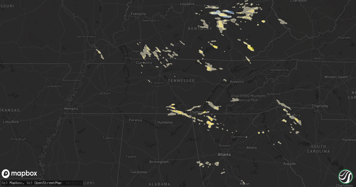
Hail Map in Tennessee on August 17, 2024
Get this storm
August 17 map
$229
one time, instant access
Download today. No call, no setup
Keep the $229
Bought the map and want the full workflow? Apply the entire $229 to a subscription within 7 days. None of it is wasted.
Every map, not just this one
This buys you this map. Subscription and you get every map we run, in the markets you choose from a few cities to whole states to nationwide. Plus real-time alerts the moment a storm fires.
Contact data
Name, contact info, occupancy, even credit band for addresses in the footprint. You go from where it hit to who to call.
Become the source they trust
Unlimited branding weather history reports on demand. You already have the documented answer ready for the property owner, and you are the one who showed up with it.
Property data and RoofTrace estimates
Pull up any address you have got, its value and the exact code rules for that jurisdiction, straight from One Click Code. Then RoofTrace estimates the squares, pitch, and roof value, priced the way you price.
Storm reports in Tennessee
Tennessee
| Date | Description |
|---|---|
| 08/17/20243:10 PM CDT | Four to five trees down on etowah road or hwy 411 in benton. Time estimated from radar. |
| 08/17/20243:10 PM CDT | One tree down and power lines down in ocoee tn. Time estimated by radar. |
| 08/17/20242:50 PM CDT | Power lines down southwest of soddy daisy. Time estimated from radar. Location roberts mill road and levi road. |
| 08/17/20242:50 PM CDT | Trees down on blue springs road near hungry hollow road. Trees down on dalton pike hwy 60 in the flint springs area. Time estimated from radar. |
| 08/17/20242:40 PM CDT | Trees down in the walden and fairmont area. Time estimated from radar. |
| 08/17/20242:36 PM CDT | Trees down in the lone oak area. Time estimated from radar. |
| 08/17/20242:33 PM CDT | Trees were reported down in sherwood. Time estimated by radar. |
| 08/17/20242:33 PM CDT | Two trees were reported down blocking a lane of tn highway 56 near the railroad tracks. In sherwood. Time estimated by radar. |
| 08/17/20242:30 PM CDT | Trees down in the whitwell area. Time estimated from radar. |
| 08/17/20242:30 PM CDT | Social media report of quarter sized hail in east brainerd. Time estimated from radar. |
| 08/17/20242:26 PM CDT | Trees were reported down on spring creek road. Time estimated by radar. |
| 08/17/20242:20 PM CDT | Trees down in the jasper area and elsewhere in the county. |
| 08/17/20242:18 PM CDT | Trees were reported down on rock creek road. Time estimated by radar. |
| 08/17/20242:17 PM CDT | Trees were reported down on highway 130. Time estimated by radar. |
| 08/17/20242:10 PM CDT | Trees down in jasper highlands community. Time estimated from radar. |
| 08/17/20242:08 PM CDT | A tree was reported down at 216 ashley road. Time estimated by radar. |
| 08/17/20242:05 PM CDT | Power poles down on rossville blvd. Location approximate from dispatch. |
| 08/17/202412:09 AM CDT | Mcghee tyson airport |
| 08/16/202411:13 PM CDT | Facebook report of a tree down blocking chester rd at birch bark dr. |
| 08/16/202410:15 PM CDT | Tspotter report of trees down on juarez dr in hermitage. |
| 08/16/202410:05 PM CDT | Tree snapped blocking 7th ave n behind the farmers market. |
| 08/16/20249:51 PM CDT | Tree down on house in the 1600 block of martin chapel rd. No injuries but minor damage to house. |
| 08/16/20249:31 PM CDT | Facebook photos show roof damage to a building at the clarksville speedway. |
| 08/16/20249:30 PM CDT | Social media reports of several trees down and minor roof damage to homes in the i-24 exit 1 and tiny town road areas. |
| 08/16/20248:25 PM CDT | 911 call center received 3 calls of downed trees as well as sporadic reports of power outages across the county. Time estimated by radar. |
| 08/16/20248:15 PM CDT | Social media report of trees and powerlines down in the western portion of the county; time is estimated from radar. |
| 08/16/20247:45 PM CDT | Several trees were blown down along pickett park hwy. |
| 08/16/20247:18 PM CDT | Trees down on beatty creek road. |
All States Impacted by Hail Map on August 17, 2024
Cities Impacted by Hail Map on August 17, 2024
- Sugar Grove, IL
- Aurora, IL
- Batavia, IL
- West Chicago, IL
- North Aurora, IL
- Geneva, IL
- Warrenville, IL
- Winfield, IL
- Carol Stream, IL
- Mooseheart, IL
- Wheaton, IL
- Addison, IL
- Glen Ellyn, IL
- Villa Park, IL
- Glendale Heights, IL
- Lombard, IL
- Elmhurst, IL
- Hillside, IL
- Berkeley, IL
- Naperville, IL
- Oak Brook, IL
- Lisle, IL
- Downers Grove, IL
- Westmont, IL
- Elkins, AR
- Picher, OK
- Tiff City, MO
- Miami, OK
- Centerton, AR
- Thayer, KS
- Galesburg, KS
- Fayetteville, AR
- Noel, MO
- Decatur, AR
- Erie, KS
- Buffalo, KS
- Benedict, KS
- Parsons, KS
- Cave Springs, AR
- Chanute, KS
- Wyandotte, OK
- Lowell, AR
- Bella Vista, AR
- Altoona, KS
- Treece, KS
- Anderson, MO
- Lincoln, AR
- Gravette, AR
- West Fork, AR
- Columbus, KS
- Seneca, MO
- Baxter Springs, KS
- Sulphur Springs, AR
- McCune, KS
- Saint Paul, KS
- Chetopa, KS
- Siloam Springs, AR
- Bartlett, KS
- Rogers, AR
- Prairie Grove, AR
- Commerce, OK
- Lanagan, MO
- Quapaw, OK
- Altamont, KS
- Gentry, AR
- South West City, MO
- Bentonville, AR
- Yates Center, KS
- Farmington, AR
- Dennis, KS
- Springdale, AR
- Goodman, MO
- Hiwasse, AR
- Oswego, KS
- Pineville, MO
- Winslow, AR
- Birch Tree, MO
- Winona, MO
- Ada, OK
- Muskogee, OK
- Vanceburg, KY
- De Mossville, KY
- Butler, KY
- Ord, NE
- Dunning, NE
- North Loup, NE
- Foster, KY
- Williamsburg, OH
- Mount Orab, OH
- Bethel, OH
- New Richmond, OH
- Moscow, OH
- Fayetteville, OH
- Scotia, NE
- Oakland, KY
- Bowling Green, KY
- Falmouth, KY
- Ellisville, MS
- Wolbach, NE
- Hillsboro, AL
- Felicity, OH
- Georgetown, OH
- Palmer, NE
- Brooksville, KY
- Frankfort, KY
- Hayneville, AL
- Aliceville, AL
- Augusta, KY
- Nashport, OH
- Hurricane, UT
- Butler, AL
- Fort Deposit, AL
- Minter, AL
- Fullerton, NE
- Belgrade, NE
- Winchester, OH
- Dover, KY
- Ripley, OH
- Russellville, OH
- Mount Sterling, KY
- Shelbyville, KY
- Waddy, KY
- Pine Apple, AL
- Jeffersonville, KY
- Frazeysburg, OH
- Belvidere, TN
- Mulberry, TN
- Winchester, TN
- Sherwood, TN
- Stevenson, AL
- Decatur, AL
- Toxey, AL
- Clarks, NE
- Cynthiana, KY
- Cadiz, OH
- West Union, OH
- Manchester, OH
- Aberdeen, OH
- Maysville, KY
- Kelso, TN
- Seaman, OH
- South Pittsburg, TN
- Meridian, MS
- Dillonvale, OH
- Adena, OH
- Seminary, MS
- Fayetteville, TN
- Germantown, KY
- Means, KY
- Paris, KY
- Bridgeport, AL
- Hartselle, AL
- Somerville, AL
- Peebles, OH
- Cecil, AL
- Mount Olivet, KY
- Carlisle, KY
- Northfield, OH
- Solon, OH
- Bedford, OH
- Shubuta, MS
- Loudonville, OH
- Perrysville, OH
- West Liberty, KY
- Sandy Hook, KY
- Clearfield, KY
- Morehead, KY
- Smithfield, OH
- Rayland, OH
- Mingo Junction, OH
- Lookout Mountain, GA
- Blue Creek, OH
- Lynx, OH
- Huntland, TN
- Elora, TN
- Flintville, TN
- Olive Hill, KY
- Stockton, NY
- Alton, UT
- Lynchburg, TN
- Shreve, OH
- Jeromesville, OH
- Wooster, OH
- Zanesville, OH
- Quitman, MS
- Stout, OH
- Wallingford, KY
- Chagrin Falls, OH
- Chattanooga, TN
- Flintstone, GA
- Rossville, GA
- Lookout Mountain, TN
- Moselle, MS
- Colliers, WV
- Wellsburg, WV
- Follansbee, WV
- Lawrenceburg, KY
- Mayslick, KY
- Tullahoma, TN
- Versailles, KY
- Salvisa, KY
- Sequatchie, TN
- Jasper, TN
- Flemingsburg, KY
- Cassadaga, NY
- Avella, PA
- Burgettstown, PA
- Tollesboro, KY
- Laceys Spring, AL
- Taylorsville, KY
- Mount Eden, KY
- Apison, TN
- Sweet Water, AL
- Estill Springs, TN
- Fosters, AL
- Falkville, AL
- Whitwell, TN
- Tracy City, TN
- Springboro, PA
- Bryant, AL
- Flat Rock, AL
- Sandyville, OH
- East Sparta, OH
- Ralph, AL
- Jackson, AL
- Grove Hill, AL
- Waynesburg, OH
- Magnolia, OH
- Frisco City, AL
- Lexington, KY
- Vossburg, MS
- Paulding, MS
- Kimbolton, OH
- Chillicothe, OH
- Ooltewah, TN
- Signal Mountain, TN
- Moundville, AL
- Union Grove, AL
- Nicholasville, KY
- Cambridge, OH
- Moorefield, KY
- Sharpsburg, KY
- Panguitch, UT
- Fort Oglethorpe, GA
- Cleveland, TN
- McDonald, TN
- Owingsville, KY
- Ray, OH
- Winchester, KY
- Richmond, KY
- Freeport, OH
- Midway, KY
- Wagarville, AL
- Charleston, TN
- Bloomingdale, OH
- Pine Hill, AL
- Tuscaloosa, AL
- Port Washington, OH
- Cottondale, AL
- Elkfork, KY
- Hollytree, AL
- Birchwood, TN
- Soddy Daisy, TN
- Trenton, GA
- Hillsboro, KY
- Thomaston, AL
- Arlington, AL
- Crandall, GA
- New Market, AL
- Springfield, KY
- Cisco, GA
- Chatsworth, GA
- Hollywood, AL
- Georgetown, TN
- Old Fort, TN
- Leroy, AL
- Ocoee, TN
- Benton, TN
- Uriah, AL
- Rising Fawn, GA
- Georgetown, KY
- Catherine, AL
- Wilmore, KY
- Hopedale, OH
- Hazel Green, AL
- Cusseta, AL
- Sale Creek, TN
- Ringgold, GA
- Cohutta, GA
- Tunnel Hill, GA
- Delano, TN
- Jewett, OH
- Alberta, AL
- Dalton, GA
- Wildwood, GA
- Seibert, CO
- Oil City, PA
- Heidelberg, MS
- Steubenville, OH
- Reliance, TN
- Titusville, PA
- Eva, AL
- Chickamauga, GA
- Lancaster, KY
- Macon, GA
- Camden, AL
- Higdon, AL
- Grove City, PA
- Volant, PA
- Mercer, PA
- Estillfork, AL
- Silver Creek, MS
- Vona, CO
- Stratton, CO
- La Fayette, GA
- Rocky Face, GA
- Weirton, WV
- Rock Spring, GA
- Mackville, KY
- Hendersonville, NC
- McCalla, AL
- Brookwood, AL
- Bessemer, AL
- Slippery Rock, PA
- Henagar, AL
- Wolf Creek, OR
- Menlo, GA
- Salt Lick, KY
- Ider, AL
- Cooperstown, PA
- Sonoita, AZ
- Opp, AL
- Olympia, KY
- Frenchburg, KY
- Flat Rock, NC
- Mount Vernon, AL
- Montevallo, AL
- Randolph, AL
- Portersville, PA
- Blountsville, AL
- Oneonta, AL
- McIntosh, AL
- Clay City, KY
- Stanton, KY
- Denniston, KY
- Wellington, KY
- Conover, NC
- Waco, KY
- Irvine, KY
- Perryville, KY
- Gravel Switch, KY
- Abbeville, GA
- Chunchula, AL
- Claremont, NC
- Wilsondale, WV
- Kermit, WV
- Crum, WV
- Lebanon, KY
- Loretto, KY
- Le Roy, NY
- Heber City, UT
- Kamas, UT
- Mountain Home, UT
- Tabiona, UT
- Roosevelt, UT
- Fruitland, UT
- Hanna, UT
- Evanston, WY
- Coalville, UT
- Woodruff, UT
- Tropic, UT
- Bryce, UT
- Escalante, UT
- Saluda, NC
- Hydetown, PA
- Sugar Valley, GA
- Calhoun, GA
- Resaca, GA
- Catawba, NC
- Centerville, PA
- Townville, PA
- Calera, AL
- Jemison, AL
- Brierfield, AL
- Breeden, WV
- Hickory, NC
- Summerville, GA
- Marion, AL
- Paint Lick, KY
- Ezel, KY
- Campton, KY
- Slade, KY
- Alabaster, AL
- Dingess, WV
- Salyersville, KY
- Hagerhill, KY
- Lucedale, MS
- Crab Orchard, KY
- Talking Rock, GA
- Ranger, GA
- Monticello, MS
- Jayess, MS
- Ruth, MS
- Chapmanville, WV
- Vail, AZ
- Chelsea, AL
- Alexandria, OH
- Johnstown, OH
- Pataskala, OH
- Eight Mile, AL
- Bogue Chitto, MS
- Clanton, AL
- Angie, LA
- Hazel Green, KY
- Saraland, AL
- Saint Louisville, OH
- Utica, OH
- Tryon, NC
- Columbus, NC
- Maplesville, AL
- Thorsby, AL
- Bethany, WV
- Brilliant, OH
- Parksville, KY
- Bradfordsville, KY
- Ellijay, GA
- Berea, KY
- Newton, NC
- Maiden, NC
- Logan, WV
- Coshocton, OH
- Harrodsburg, KY
- Plantersville, AL
- Bardwell, KY
- Sugar Grove, PA
- Warren, PA
- Russell, PA
- Granville, OH
- Robbinsville, NC
- Gadsden, AL
- Landrum, SC
- Colorado City, AZ
- Lenore, WV
- Lovely, KY
- Williamson, WV
- Campobello, SC
- Warsaw, OH
- Tellico Plains, TN
- Hickory, PA
- Arlington, KY
- Holden, WV
- Paducah, TX
- Stanford, KY
- Bethune, CO
- Clinton, KY
- Delbarton, WV
- Oakridge, OR
- Rockfield, KY
- Inman, SC
- Sylacauga, AL
- Childersburg, AL
- Ravenna, OH
- Pavilion, NY
- Talladega, AL
- Alpine, AL
- Jasper, GA
- Cokeville, WY
- Fort Bridger, WY
- Diamondville, WY
- Granger, WY
- Opal, WY
- McKinnon, WY
- Green River, WY
- Kemmerer, WY
- Mountain View, WY
- Lyman, WY
- Robertson, WY
- La Barge, WY
- Big Piney, WY
- Boulder, WY
- Pinedale, WY
- Bondurant, WY
- Daniel, WY
- Rock Springs, WY
- Cora, WY
- Farson, WY
- Superior, WY
- Reliance, WY
- Lander, WY
- Churchville, NY
- Chesnee, SC
- Ravenna, KY
- Prestonsburg, KY
- Akron, OH
- Brodhead, KY
- Isonville, KY
- Belfry, KY
- Mount Vernon, KY
- Mize, KY
- Burlington, CO
- Idanha, OR
- Bear Lake, PA
- Spartanburg, SC
- Canal Fulton, OH
- Clinton, OH
- Kent, OH
- Matewan, WV
- Wingo, KY
- Cannon Afb, NM
- Clovis, NM
- Uniontown, OH
- Marble Hill, GA
- Dawsonville, GA
- Tumacacori, AZ
- Liberty, MS
- Una, SC
- Tucson, AZ
- Youngsville, PA
- Man, WV
- Stollings, WV
- Yolyn, WV
- Lyburn, WV
- Switzer, WV
- Manchester, KY
- Twinsburg, OH
- Amherstdale, WV
- Jonesville, SC
- Pacolet, SC
- Canon, GA
- Roebuck, SC
- Arcadia, SC
- Trinity Center, CA
- Bowersville, GA
- Lavonia, GA
- Pauline, SC
- Russellville, KY
- Lewisburg, KY
- Grayson, LA
- Hartwell, GA
- Rousseau, KY
- Tallmadge, OH
- Cottonwood, CA
- Red Bluff, CA
- Riverton, WY
- Arapahoe, WY
- Fort Washakie, WY
- Hudson, WY
- Jeffrey City, WY
- Wamsutter, WY
- Bairoil, WY
- Crowheart, WY
- Kinnear, WY
- Dubois, WY
- Auburn, KY
- Wellford, SC
- Heflin, AL
- Ranburne, AL
- Big Creek, KY
- Union, SC
- Jackson, KY
- Buffalo, SC
- Bloomfield, KY
- Coxs Creek, KY
- Estacada, OR
- Saint George, UT
- Snyder, TX
- Cuyahoga Falls, OH
- Lakemore, OH
- Graham, AL
- Helton, KY
- Bledsoe, KY
- Burkesville, KY
- Picayune, MS
- Cave City, KY
- Atmore, AL
- Century, FL
- Dahlonega, GA
- Roark, KY
- Essie, KY
- Woodland, AL
- Redding, CA
- Anderson, CA
- Lakehead, CA
- Simpsonville, SC
- Sandy, OR
- Beattyville, KY
- Hammond, LA
- Tickfaw, LA
- Russell Springs, KY
- Nancy, KY
- Sells, AZ
- Jamestown, KY
- Moore, SC
- Bush, LA
- Bogalusa, LA
- Albany, KY
- Glasgow, KY
- Park City, KY
- Bowdon, GA
- Roopville, GA
- Woodruff, SC
- Fountain Inn, SC
- Ponchatoula, LA
- Science Hill, KY
- Brightwood, OR
- Welches, OR
- Rhododendron, OR
- Government Camp, OR
- Rawlins, WY
- Saratoga, WY
- Encampment, WY
- Savery, WY
- Baggs, WY
- Dixon, WY
- Wellsville, OH
- Pine Valley, UT
- Irving, NY
- Windsor, KY
- Monticello, KY
- Springfield, LA
- Scottsville, KY
- Byrdstown, TN
- Maysville, GA
- Hammondsville, OH
- Greer, SC
- Franklin, GA
- Daviston, AL
- Alexander City, AL
- Enoree, SC
- Whitmire, SC
- Anderson, SC
- Bronston, KY
- Somerset, KY
- Adolphus, KY
- Allons, TN
- Stanton, AL
- Clinton, SC
- Morganton, NC
- Monroe, TN
- Columbus, PA
- Lawley, AL
- Braddock, PA
- Pittsburgh, PA
- Hanna, WY
- Sinclair, WY
- Rock River, WY
- Laramie, WY
- Centennial, WY
- Bosler, WY
- Elk Mountain, WY
- Buford, WY
- Jelm, WY
- Rainbow City, AL
- Madras, OR
- Warm Springs, OR
- Middlesboro, KY
- Sharpsburg, GA
- Tyrone, GA
- Palmetto, GA
- Odenville, AL
- Moody, AL
- Port Allegany, PA
- Shinglehouse, PA
- Maupin, OR
- Detroit, OR
- Kinards, SC
- Petersburg, PA
- Hopkinsville, KY
- Elkton, KY
- Harrogate, TN
- Ewing, VA
- Abbeville, SC
- Bradley, SC
- Delta, AL
- Newnan, GA
- Calhoun Falls, SC
- Mount Carmel, SC
- Stevenson, WA
- Conneaut Lake, PA
- Linesville, PA
- Jamestown, TN
- Pall Mall, TN
- Tazewell, TN
- Williamson, GA
- Griffin, GA
- Huntingdon, PA
- Concord, GA
- Crofton, KY
- Dawson Springs, KY
- Olmstead, KY
- Fillmore, UT
- Sneedville, TN
- Dufur, OR
- Baton Rouge, LA
- Saint Gabriel, LA
- Sharon Grove, KY
- Alexandria, PA
- Alvaton, KY
- Shaniko, OR
- Adairville, KY
- Talent, OR
- Medford, OR
- Woodburn, KY
- The Dalles, OR
- Franklin, KY
- Trenton, KY
- Pembroke, KY
- Wilder, TN
- Thorn Hill, TN
- Kentwood, LA
- Mozelle, KY
- Carrollton, GA
- Newberry, SC
- Randle, WA
- Morton, WA
- Linwood, NY
- Caledonia, NY
- Piffard, NY
- Phoenix, OR
- Whitesburg, GA
- Allensville, KY
- Guthrie, KY
- White Salmon, WA
- Trout Lake, WA
- Warbranch, KY
- Stinnett, KY
- Hyden, KY
- Jena, LA
- Centerville, WA
- Wishram, WA
- Wasco, OR
- Portland, TN
- Oak Grove, KY
- Marshall, NC
- Leicester, NC
- Alexander, NC
- Peachtree City, GA
- Springfield, TN
- White House, TN
- Grass Valley, OR
- Kent, OR
- Moro, OR
- Arlington, OR
- Condon, OR
- Wendover, UT
- Bethpage, TN
- Gallatin, TN
- Baxter, KY
- Cross Plains, TN
- Allardt, TN
- Roosevelt, WA
- Rufus, OR
- Goldendale, WA
- Bickleton, WA
- Willcox, AZ
- Hendersonville, TN
- Cottontown, TN
- Robbins, TN
- Sunbright, TN
- Clarksville, TN
- Greenbrier, TN
- Goodlettsville, TN
- Joelton, TN
- Mount Hood Parkdale, OR
- Glens Fork, KY
- Westmoreland, TN
- Rio Rico, AZ
- Rogers, KY
- Lewistown, PA
- Vanleer, TN
- Huntsville, TN
- Enumclaw, WA
- Lebanon, TN
- Walhonding, OH
- Cunningham, TN
- Palmyra, TN
- Buckley, WA
- Watertown, TN
- Wellsville, NY
- Whitesville, NY
- Andover, NY
- Deer Lodge, TN
- Dugway, UT
- Oliver Springs, TN
- Harriman, TN
- Fairview, TN
- Bon Aqua, TN
- Oak Ridge, TN
- Dalton, NY
- Swain, NY
- Greeneville, TN
- Pendleton, OR
- Plymouth, WA
- Umatilla, OR
- Prosser, WA
- Mabton, WA
- Helix, OR
- Boardman, OR
- Stanfield, OR
- Irrigon, OR
- Kennewick, WA
- Hermiston, OR
- Heppner, OR
- Lexington, OR
- Ione, OR
- Pilot Rock, OR
- Echo, OR
- Parkers Lake, KY
- Dunnville, KY
- Harlan, KY
- Oneida, KY
- Richmond, OH
- Greeley, NE
- Fort Mcdowell, AZ
- Okaton, SD
- Murdo, SD
- Midland, SD
- Draper, SD
- Milesville, SD
- Vivian, SD
- Hayes, SD
- Fort Pierre, SD
- Presho, SD
- Ideal, SD
- Winner, SD
- Witten, SD
- Dallas, SD
- Tryon, NE
- Colome, SD
- Wood, SD
- Gregory, SD
- Burke, SD
- Herrick, SD
- Mills, NE
- Naper, NE
- Atkinson, NE
- Stuart, NE
- Emmet, NE
- Oneill, NE
- Newport, NE
- Chambers, NE
- Ewing, NE
- Inman, NE


