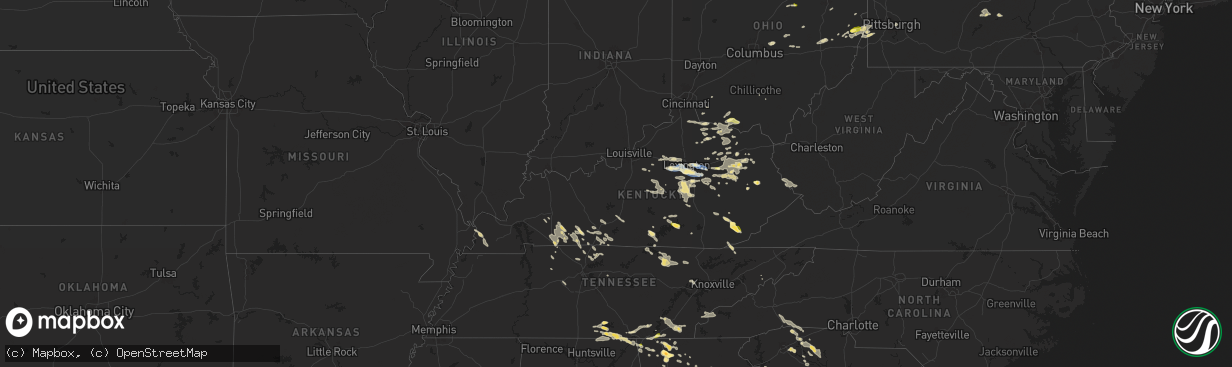
Hail Map in Kentucky on August 17, 2024
The weather event in Kentucky on August 17, 2024 includes Wind and Hail maps. 30 states and 843 cities were impacted and suffered possible damage. The total estimated number of properties impacted is 3,475.
Want more than just the map?
Turn this storm into a full workflow.
- Owner + property data so you know who to knock
- OnDemand branded weather history reports to win the "did we even have hail?" argument
- RoofTrace estimate so reps stop guessing numbers at the door
Bought this map? Upgrade within 7 days and we'll credit the $230. (10-15 min setup call)
Wind
Hail
3,475
Estimated number of impacted properties by a 1.00" hail or larger0
Estimated number of impacted properties by a 1.75" hail or larger0
Estimated number of impacted properties by a 2.50" hail or largerStorm reports in Kentucky
Kentucky
| Date | Description |
|---|---|
| 08/17/20246:59 PM CDT | A public report of hail was received via twitter with pictures from a location east of harlan off of ky 38 on shell hollow road also known as eubank road. |
| 08/17/20246:58 PM CDT | Numerous trees down along us 127 in the north part of the county. |
| 08/17/20246:40 PM CDT | Trained spotter shared pictures of a couple of open faced barns destroyed. Power poles were also broken which resulted in 400 power outages in the area. |
| 08/17/20246:36 PM CDT | Trees down near the intersection of plainview church road and proctor mill road. |
| 08/17/20246:34 PM CDT | A social media report of hail up to half dollar size was received with pictures. The hail fell off of us 421 at elmer lane between mozelle and helton closer to mozelle. |
| 08/17/20245:55 PM CDT | Trees down on powerlines on old state road in brandenburg. |
| 08/17/20245:23 PM CDT | A power line was reported to be hanging across the caleb fork road in the community of weeksbury due to a downed tree. Time estimated by radar. |
| 08/17/20245:15 PM CDT | A tree was downed onto hwy 122 in the hight hat community. Time estimated by radar. |
| 08/17/20245:04 PM CDT | A tree was blown down just south of ky 30 in a location about 1 road mile east of airport road. The event time is estimated from radar and nearby observations. |
| 08/17/20245:02 PM CDT | A tree was downed near mm 1 of ky-3680 in the drift community. Time estimated by radar. |
| 08/17/20244:52 PM CDT | A telephone pole was downed by winds along cliff road in prestonsburg. Time estimated by radar. |
| 08/17/20244:52 PM CDT | Trees and powerlines down at the intersection of russellville road and dishman lane. |
| 08/17/20244:50 PM CDT | A tree was downed onto a power line around 2950 arkansas creek road... Just southeast of the town of martin. Time estimated by radar. |
| 08/17/20244:45 PM CDT | A tree was felled near 1090 abbott creek road. |
| 08/17/20244:45 PM CDT | Trees down on fairground rd. Time estimated from radar. |
| 08/17/20244:42 PM CDT | Trees down on airport road near lincoln boyle county line. Time estimated from radar. |
| 08/17/20244:41 PM CDT | A tree was reported down at the 6900 block of ky-404 near the community of david. Time estimated by radar. |
| 08/17/20244:38 PM CDT | Trees down on elm street. Time estimated from radar. |
| 08/17/20244:30 PM CDT | Trees down on black pike near hustonville. Time estimated from radar. |
| 08/17/20244:25 PM CDT | Trees down on elk cave branch rd. Time estimated from radar. |
| 08/17/20244:21 PM CDT | Large healthy tree down on stamper branch rd. |
| 08/17/20244:15 PM CDT | The 911 call center received 21 reports of trees down from around the county and 2 reports of downed power lines. Most of the trees were blown down along brown ridge ro |
| 08/17/20244:11 PM CDT | Corrects time of previous tstm wnd dmg report from 1 e pitts. Delayed social media report of downed large tree branches at 3135 tipton ridge road. Time estimated via ra |
| 08/17/20244:10 PM CDT | Few trees down near ellipse street as well walnut meadow area. Very rough estimate time... With strong outflow passing through around 5 pm and a new storm moving over t |
| 08/17/20244:07 PM CDT | Multiple trees down along chimney top road in the red river gorge. |
| 08/17/20244:07 PM CDT | Tree down on vehicle along highway 715. |
| 08/17/20244:06 PM CDT | Several trees down in this area. Intersection of mitchellsburg rd and harberson ln. Bakers ln. And around the 9700 and 10300 block of lebanon rd. Also somewhere on scru |
| 08/17/20244:03 PM CDT | Twitter post with picture of tree down in richmond battlefield park. Time estimated from radar. |
| 08/17/20244:00 PM CDT | Trees down in the 4500 block of webster rd. Time estimated from radar. |
| 08/17/20243:57 PM CDT | Trees down on gillispie pike and hwy 1295. Time estimated from radar. |
| 08/17/20243:47 PM CDT | Metal siding removed from home. |
| 08/17/20243:44 PM CDT | Tree down along brandy lane. Time estimated by radar. |
| 08/17/20243:44 PM CDT | Tree down along campton rd. Time estimated by radar. |
| 08/17/20243:44 PM CDT | A tree was blown down and across highway 746 in wellington. Another tree was blown down and onto a powerline on camp judy lane in wellington. |
| 08/17/20243:44 PM CDT | A tree was blown down on fletcher road off tar ridge road in frenchburg. |
| 08/17/20243:43 PM CDT | Trees down on oscar ray as well as tommy murphy rd. Time estimated from radar. |
| 08/17/20243:42 PM CDT | Tree down along darrel randall rd. Time estimated by radar. |
| 08/17/20243:41 PM CDT | Tree down on structure. Time estimated by radar. |
| 08/17/20243:37 PM CDT | Corrects location and time of previous tstm wnd dmg report from 7 s clearfield. A tree was blown down on bangor boat dock road along cave run lake. |
| 08/17/20243:35 PM CDT | A tree was blown down east of elliottville near the elliott county line. |
| 08/17/20243:34 PM CDT | A tree was blown down at the bangor boat ramp along cave run lake 7 miles south of clearfield. |
| 08/17/20243:19 PM CDT | Twitter report of power lines snapped near the taco bell in winchester. |
| 08/17/20243:18 PM CDT | Large tree down and power lines down in mackville. |
| 08/17/20243:01 PM CDT | Large tree down across road on crawley lane. |
| 08/17/20242:58 PM CDT | A tree was blown down at 920 sunset road in hillsboro. |
| 08/17/20242:54 PM CDT | Multiple reports of tree damage and power lines down in south lexington... Including on jairus drive. |
| 08/17/20242:54 PM CDT | Power lines down. |
| 08/17/20242:50 PM CDT | Mesonet station wnch winchester 3 nw. |
| 08/17/20242:49 PM CDT | Power outage reported at a business. |
| 08/17/20242:44 PM CDT | Large tree down on clintonville rd at van meter rd. Time estimated from radar. |
| 08/17/20242:43 PM CDT | Large tree branch snapped and fell onto a home in south lexington. |
| 08/17/20242:43 PM CDT | Multiple trees were blown down on praiter road in mount carmel. |
| 08/17/20242:37 PM CDT | Estimated 50 to 60 mph winds from two different sources near the jessamine and fayette county line. |
| 08/17/20242:32 PM CDT | Asos station klex lexington. |
| 08/17/20242:25 PM CDT | Large tree limb down on vehicle in woodland park. |
| 08/17/20242:25 PM CDT | Utility company reports tree down on lines along hilton branch road. Time estimated from radar. |
| 08/17/20242:06 PM CDT | A tree was blown down on ky-557 near sandy hook. |
| 08/17/20242:05 PM CDT | Video from concord area showing numerous branches down. Time estimated from radar. |
| 08/17/20241:46 PM CDT | . |
| 08/17/20241:46 PM CDT | A local report indicates 1.00 inch wind near 1 S Oggs Station |
| 08/17/20241:38 PM CDT | Scattered minor tree damage reported in downtown frankfort and on the east side of town. Estimated 900 to 950 people without power. |
| 08/17/20241:25 PM CDT | Delayed report. Tobacco barn destroyed... Likely from a small downburst. Multiple storms went through the area that afternoon. Tcvg used to estimate timing of downburst |
| 08/17/202412:11 PM CDT | Delayed social media report of downed large tree branches at 3135 tipton ridge road. Time estimated via radar. |
| 08/16/20247:12 PM CDT | Half dollar size hail was reported via social media with pictures included. The event occurred at a residence on springs road to the southwest of somerset not far from |
All States Impacted by Hail Map on August 17, 2024
Cities Impacted by Hail Map on August 17, 2024
- Sugar Grove, IL
- Aurora, IL
- Batavia, IL
- West Chicago, IL
- North Aurora, IL
- Geneva, IL
- Warrenville, IL
- Winfield, IL
- Carol Stream, IL
- Mooseheart, IL
- Wheaton, IL
- Addison, IL
- Glen Ellyn, IL
- Villa Park, IL
- Glendale Heights, IL
- Lombard, IL
- Elmhurst, IL
- Hillside, IL
- Berkeley, IL
- Naperville, IL
- Oak Brook, IL
- Lisle, IL
- Downers Grove, IL
- Westmont, IL
- Elkins, AR
- Picher, OK
- Tiff City, MO
- Miami, OK
- Centerton, AR
- Thayer, KS
- Galesburg, KS
- Fayetteville, AR
- Noel, MO
- Decatur, AR
- Erie, KS
- Buffalo, KS
- Benedict, KS
- Parsons, KS
- Cave Springs, AR
- Chanute, KS
- Wyandotte, OK
- Lowell, AR
- Bella Vista, AR
- Altoona, KS
- Treece, KS
- Anderson, MO
- Lincoln, AR
- Gravette, AR
- West Fork, AR
- Columbus, KS
- Seneca, MO
- Baxter Springs, KS
- Sulphur Springs, AR
- McCune, KS
- Saint Paul, KS
- Chetopa, KS
- Siloam Springs, AR
- Bartlett, KS
- Rogers, AR
- Prairie Grove, AR
- Commerce, OK
- Lanagan, MO
- Quapaw, OK
- Altamont, KS
- Gentry, AR
- South West City, MO
- Bentonville, AR
- Yates Center, KS
- Farmington, AR
- Dennis, KS
- Springdale, AR
- Goodman, MO
- Hiwasse, AR
- Oswego, KS
- Pineville, MO
- Winslow, AR
- Birch Tree, MO
- Winona, MO
- Ada, OK
- Muskogee, OK
- Vanceburg, KY
- De Mossville, KY
- Butler, KY
- Ord, NE
- Dunning, NE
- North Loup, NE
- Foster, KY
- Williamsburg, OH
- Mount Orab, OH
- Bethel, OH
- New Richmond, OH
- Moscow, OH
- Fayetteville, OH
- Scotia, NE
- Oakland, KY
- Bowling Green, KY
- Falmouth, KY
- Ellisville, MS
- Wolbach, NE
- Hillsboro, AL
- Felicity, OH
- Georgetown, OH
- Palmer, NE
- Brooksville, KY
- Frankfort, KY
- Hayneville, AL
- Aliceville, AL
- Augusta, KY
- Nashport, OH
- Hurricane, UT
- Butler, AL
- Fort Deposit, AL
- Minter, AL
- Fullerton, NE
- Belgrade, NE
- Winchester, OH
- Dover, KY
- Ripley, OH
- Russellville, OH
- Mount Sterling, KY
- Shelbyville, KY
- Waddy, KY
- Pine Apple, AL
- Jeffersonville, KY
- Frazeysburg, OH
- Belvidere, TN
- Mulberry, TN
- Winchester, TN
- Sherwood, TN
- Stevenson, AL
- Decatur, AL
- Toxey, AL
- Clarks, NE
- Cynthiana, KY
- Cadiz, OH
- West Union, OH
- Manchester, OH
- Aberdeen, OH
- Maysville, KY
- Kelso, TN
- Seaman, OH
- South Pittsburg, TN
- Meridian, MS
- Dillonvale, OH
- Adena, OH
- Seminary, MS
- Fayetteville, TN
- Germantown, KY
- Means, KY
- Paris, KY
- Bridgeport, AL
- Hartselle, AL
- Somerville, AL
- Peebles, OH
- Cecil, AL
- Mount Olivet, KY
- Carlisle, KY
- Northfield, OH
- Solon, OH
- Bedford, OH
- Shubuta, MS
- Loudonville, OH
- Perrysville, OH
- West Liberty, KY
- Sandy Hook, KY
- Clearfield, KY
- Morehead, KY
- Smithfield, OH
- Rayland, OH
- Mingo Junction, OH
- Lookout Mountain, GA
- Blue Creek, OH
- Lynx, OH
- Huntland, TN
- Elora, TN
- Flintville, TN
- Olive Hill, KY
- Stockton, NY
- Alton, UT
- Lynchburg, TN
- Shreve, OH
- Jeromesville, OH
- Wooster, OH
- Zanesville, OH
- Quitman, MS
- Stout, OH
- Wallingford, KY
- Chagrin Falls, OH
- Chattanooga, TN
- Flintstone, GA
- Rossville, GA
- Lookout Mountain, TN
- Moselle, MS
- Colliers, WV
- Wellsburg, WV
- Follansbee, WV
- Lawrenceburg, KY
- Mayslick, KY
- Tullahoma, TN
- Versailles, KY
- Salvisa, KY
- Sequatchie, TN
- Jasper, TN
- Flemingsburg, KY
- Cassadaga, NY
- Avella, PA
- Burgettstown, PA
- Tollesboro, KY
- Laceys Spring, AL
- Taylorsville, KY
- Mount Eden, KY
- Apison, TN
- Sweet Water, AL
- Estill Springs, TN
- Fosters, AL
- Falkville, AL
- Whitwell, TN
- Tracy City, TN
- Springboro, PA
- Bryant, AL
- Flat Rock, AL
- Sandyville, OH
- East Sparta, OH
- Ralph, AL
- Jackson, AL
- Grove Hill, AL
- Waynesburg, OH
- Magnolia, OH
- Frisco City, AL
- Lexington, KY
- Vossburg, MS
- Paulding, MS
- Kimbolton, OH
- Chillicothe, OH
- Ooltewah, TN
- Signal Mountain, TN
- Moundville, AL
- Union Grove, AL
- Nicholasville, KY
- Cambridge, OH
- Moorefield, KY
- Sharpsburg, KY
- Panguitch, UT
- Fort Oglethorpe, GA
- Cleveland, TN
- McDonald, TN
- Owingsville, KY
- Ray, OH
- Winchester, KY
- Richmond, KY
- Freeport, OH
- Midway, KY
- Wagarville, AL
- Charleston, TN
- Bloomingdale, OH
- Pine Hill, AL
- Tuscaloosa, AL
- Port Washington, OH
- Cottondale, AL
- Elkfork, KY
- Hollytree, AL
- Birchwood, TN
- Soddy Daisy, TN
- Trenton, GA
- Hillsboro, KY
- Thomaston, AL
- Arlington, AL
- Crandall, GA
- New Market, AL
- Springfield, KY
- Cisco, GA
- Chatsworth, GA
- Hollywood, AL
- Georgetown, TN
- Old Fort, TN
- Leroy, AL
- Ocoee, TN
- Benton, TN
- Uriah, AL
- Rising Fawn, GA
- Georgetown, KY
- Catherine, AL
- Wilmore, KY
- Hopedale, OH
- Hazel Green, AL
- Cusseta, AL
- Sale Creek, TN
- Ringgold, GA
- Cohutta, GA
- Tunnel Hill, GA
- Delano, TN
- Jewett, OH
- Alberta, AL
- Dalton, GA
- Wildwood, GA
- Seibert, CO
- Oil City, PA
- Heidelberg, MS
- Steubenville, OH
- Reliance, TN
- Titusville, PA
- Eva, AL
- Chickamauga, GA
- Lancaster, KY
- Macon, GA
- Camden, AL
- Higdon, AL
- Grove City, PA
- Volant, PA
- Mercer, PA
- Estillfork, AL
- Silver Creek, MS
- Vona, CO
- Stratton, CO
- La Fayette, GA
- Rocky Face, GA
- Weirton, WV
- Rock Spring, GA
- Mackville, KY
- Hendersonville, NC
- McCalla, AL
- Brookwood, AL
- Bessemer, AL
- Slippery Rock, PA
- Henagar, AL
- Wolf Creek, OR
- Menlo, GA
- Salt Lick, KY
- Ider, AL
- Cooperstown, PA
- Sonoita, AZ
- Opp, AL
- Olympia, KY
- Frenchburg, KY
- Flat Rock, NC
- Mount Vernon, AL
- Montevallo, AL
- Randolph, AL
- Portersville, PA
- Blountsville, AL
- Oneonta, AL
- McIntosh, AL
- Clay City, KY
- Stanton, KY
- Denniston, KY
- Wellington, KY
- Conover, NC
- Waco, KY
- Irvine, KY
- Perryville, KY
- Gravel Switch, KY
- Abbeville, GA
- Chunchula, AL
- Claremont, NC
- Wilsondale, WV
- Kermit, WV
- Crum, WV
- Lebanon, KY
- Loretto, KY
- Le Roy, NY
- Heber City, UT
- Kamas, UT
- Mountain Home, UT
- Tabiona, UT
- Roosevelt, UT
- Fruitland, UT
- Hanna, UT
- Evanston, WY
- Coalville, UT
- Woodruff, UT
- Tropic, UT
- Bryce, UT
- Escalante, UT
- Saluda, NC
- Hydetown, PA
- Sugar Valley, GA
- Calhoun, GA
- Resaca, GA
- Catawba, NC
- Centerville, PA
- Townville, PA
- Calera, AL
- Jemison, AL
- Brierfield, AL
- Breeden, WV
- Hickory, NC
- Summerville, GA
- Marion, AL
- Paint Lick, KY
- Ezel, KY
- Campton, KY
- Slade, KY
- Alabaster, AL
- Dingess, WV
- Salyersville, KY
- Hagerhill, KY
- Lucedale, MS
- Crab Orchard, KY
- Talking Rock, GA
- Ranger, GA
- Monticello, MS
- Jayess, MS
- Ruth, MS
- Chapmanville, WV
- Vail, AZ
- Chelsea, AL
- Alexandria, OH
- Johnstown, OH
- Pataskala, OH
- Eight Mile, AL
- Bogue Chitto, MS
- Clanton, AL
- Angie, LA
- Hazel Green, KY
- Saraland, AL
- Saint Louisville, OH
- Utica, OH
- Tryon, NC
- Columbus, NC
- Maplesville, AL
- Thorsby, AL
- Bethany, WV
- Brilliant, OH
- Parksville, KY
- Bradfordsville, KY
- Ellijay, GA
- Berea, KY
- Newton, NC
- Maiden, NC
- Logan, WV
- Coshocton, OH
- Harrodsburg, KY
- Plantersville, AL
- Bardwell, KY
- Sugar Grove, PA
- Warren, PA
- Russell, PA
- Granville, OH
- Robbinsville, NC
- Gadsden, AL
- Landrum, SC
- Colorado City, AZ
- Lenore, WV
- Lovely, KY
- Williamson, WV
- Campobello, SC
- Warsaw, OH
- Tellico Plains, TN
- Hickory, PA
- Arlington, KY
- Holden, WV
- Paducah, TX
- Stanford, KY
- Bethune, CO
- Clinton, KY
- Delbarton, WV
- Oakridge, OR
- Rockfield, KY
- Inman, SC
- Sylacauga, AL
- Childersburg, AL
- Ravenna, OH
- Pavilion, NY
- Talladega, AL
- Alpine, AL
- Jasper, GA
- Cokeville, WY
- Fort Bridger, WY
- Diamondville, WY
- Granger, WY
- Opal, WY
- McKinnon, WY
- Green River, WY
- Kemmerer, WY
- Mountain View, WY
- Lyman, WY
- Robertson, WY
- La Barge, WY
- Big Piney, WY
- Boulder, WY
- Pinedale, WY
- Bondurant, WY
- Daniel, WY
- Rock Springs, WY
- Cora, WY
- Farson, WY
- Superior, WY
- Reliance, WY
- Lander, WY
- Churchville, NY
- Chesnee, SC
- Ravenna, KY
- Prestonsburg, KY
- Akron, OH
- Brodhead, KY
- Isonville, KY
- Belfry, KY
- Mount Vernon, KY
- Mize, KY
- Burlington, CO
- Idanha, OR
- Bear Lake, PA
- Spartanburg, SC
- Canal Fulton, OH
- Clinton, OH
- Kent, OH
- Matewan, WV
- Wingo, KY
- Cannon Afb, NM
- Clovis, NM
- Uniontown, OH
- Marble Hill, GA
- Dawsonville, GA
- Tumacacori, AZ
- Liberty, MS
- Una, SC
- Tucson, AZ
- Youngsville, PA
- Man, WV
- Stollings, WV
- Yolyn, WV
- Lyburn, WV
- Switzer, WV
- Manchester, KY
- Twinsburg, OH
- Amherstdale, WV
- Jonesville, SC
- Pacolet, SC
- Canon, GA
- Roebuck, SC
- Arcadia, SC
- Trinity Center, CA
- Bowersville, GA
- Lavonia, GA
- Pauline, SC
- Russellville, KY
- Lewisburg, KY
- Grayson, LA
- Hartwell, GA
- Rousseau, KY
- Tallmadge, OH
- Cottonwood, CA
- Red Bluff, CA
- Riverton, WY
- Arapahoe, WY
- Fort Washakie, WY
- Hudson, WY
- Jeffrey City, WY
- Wamsutter, WY
- Bairoil, WY
- Crowheart, WY
- Kinnear, WY
- Dubois, WY
- Auburn, KY
- Wellford, SC
- Heflin, AL
- Ranburne, AL
- Big Creek, KY
- Union, SC
- Jackson, KY
- Buffalo, SC
- Bloomfield, KY
- Coxs Creek, KY
- Estacada, OR
- Saint George, UT
- Snyder, TX
- Cuyahoga Falls, OH
- Lakemore, OH
- Graham, AL
- Helton, KY
- Bledsoe, KY
- Burkesville, KY
- Picayune, MS
- Cave City, KY
- Atmore, AL
- Century, FL
- Dahlonega, GA
- Roark, KY
- Essie, KY
- Woodland, AL
- Redding, CA
- Anderson, CA
- Lakehead, CA
- Simpsonville, SC
- Sandy, OR
- Beattyville, KY
- Hammond, LA
- Tickfaw, LA
- Russell Springs, KY
- Nancy, KY
- Sells, AZ
- Jamestown, KY
- Moore, SC
- Bush, LA
- Bogalusa, LA
- Albany, KY
- Glasgow, KY
- Park City, KY
- Bowdon, GA
- Roopville, GA
- Woodruff, SC
- Fountain Inn, SC
- Ponchatoula, LA
- Science Hill, KY
- Brightwood, OR
- Welches, OR
- Rhododendron, OR
- Government Camp, OR
- Rawlins, WY
- Saratoga, WY
- Encampment, WY
- Savery, WY
- Baggs, WY
- Dixon, WY
- Wellsville, OH
- Pine Valley, UT
- Irving, NY
- Windsor, KY
- Monticello, KY
- Springfield, LA
- Scottsville, KY
- Byrdstown, TN
- Maysville, GA
- Hammondsville, OH
- Greer, SC
- Franklin, GA
- Daviston, AL
- Alexander City, AL
- Enoree, SC
- Whitmire, SC
- Anderson, SC
- Bronston, KY
- Somerset, KY
- Adolphus, KY
- Allons, TN
- Stanton, AL
- Clinton, SC
- Morganton, NC
- Monroe, TN
- Columbus, PA
- Lawley, AL
- Braddock, PA
- Pittsburgh, PA
- Hanna, WY
- Sinclair, WY
- Rock River, WY
- Laramie, WY
- Centennial, WY
- Bosler, WY
- Elk Mountain, WY
- Buford, WY
- Jelm, WY
- Rainbow City, AL
- Madras, OR
- Warm Springs, OR
- Middlesboro, KY
- Sharpsburg, GA
- Tyrone, GA
- Palmetto, GA
- Odenville, AL
- Moody, AL
- Port Allegany, PA
- Shinglehouse, PA
- Maupin, OR
- Detroit, OR
- Kinards, SC
- Petersburg, PA
- Hopkinsville, KY
- Elkton, KY
- Harrogate, TN
- Ewing, VA
- Abbeville, SC
- Bradley, SC
- Delta, AL
- Newnan, GA
- Calhoun Falls, SC
- Mount Carmel, SC
- Stevenson, WA
- Conneaut Lake, PA
- Linesville, PA
- Jamestown, TN
- Pall Mall, TN
- Tazewell, TN
- Williamson, GA
- Griffin, GA
- Huntingdon, PA
- Concord, GA
- Crofton, KY
- Dawson Springs, KY
- Olmstead, KY
- Fillmore, UT
- Sneedville, TN
- Dufur, OR
- Baton Rouge, LA
- Saint Gabriel, LA
- Sharon Grove, KY
- Alexandria, PA
- Alvaton, KY
- Shaniko, OR
- Adairville, KY
- Talent, OR
- Medford, OR
- Woodburn, KY
- The Dalles, OR
- Franklin, KY
- Trenton, KY
- Pembroke, KY
- Wilder, TN
- Thorn Hill, TN
- Kentwood, LA
- Mozelle, KY
- Carrollton, GA
- Newberry, SC
- Randle, WA
- Morton, WA
- Linwood, NY
- Caledonia, NY
- Piffard, NY
- Phoenix, OR
- Whitesburg, GA
- Allensville, KY
- Guthrie, KY
- White Salmon, WA
- Trout Lake, WA
- Warbranch, KY
- Stinnett, KY
- Hyden, KY
- Jena, LA
- Centerville, WA
- Wishram, WA
- Wasco, OR
- Portland, TN
- Oak Grove, KY
- Marshall, NC
- Leicester, NC
- Alexander, NC
- Peachtree City, GA
- Springfield, TN
- White House, TN
- Grass Valley, OR
- Kent, OR
- Moro, OR
- Arlington, OR
- Condon, OR
- Wendover, UT
- Bethpage, TN
- Gallatin, TN
- Baxter, KY
- Cross Plains, TN
- Allardt, TN
- Roosevelt, WA
- Rufus, OR
- Goldendale, WA
- Bickleton, WA
- Willcox, AZ
- Hendersonville, TN
- Cottontown, TN
- Robbins, TN
- Sunbright, TN
- Clarksville, TN
- Greenbrier, TN
- Goodlettsville, TN
- Joelton, TN
- Mount Hood Parkdale, OR
- Glens Fork, KY
- Westmoreland, TN
- Rio Rico, AZ
- Rogers, KY
- Lewistown, PA
- Vanleer, TN
- Huntsville, TN
- Enumclaw, WA
- Lebanon, TN
- Walhonding, OH
- Cunningham, TN
- Palmyra, TN
- Buckley, WA
- Watertown, TN
- Wellsville, NY
- Whitesville, NY
- Andover, NY
- Deer Lodge, TN
- Dugway, UT
- Oliver Springs, TN
- Harriman, TN
- Fairview, TN
- Bon Aqua, TN
- Oak Ridge, TN
- Dalton, NY
- Swain, NY
- Greeneville, TN
- Pendleton, OR
- Plymouth, WA
- Umatilla, OR
- Prosser, WA
- Mabton, WA
- Helix, OR
- Boardman, OR
- Stanfield, OR
- Irrigon, OR
- Kennewick, WA
- Hermiston, OR
- Heppner, OR
- Lexington, OR
- Ione, OR
- Pilot Rock, OR
- Echo, OR
- Parkers Lake, KY
- Dunnville, KY
- Harlan, KY
- Oneida, KY
- Richmond, OH
- Greeley, NE
- Fort Mcdowell, AZ
- Okaton, SD
- Murdo, SD
- Midland, SD
- Draper, SD
- Milesville, SD
- Vivian, SD
- Hayes, SD
- Fort Pierre, SD
- Presho, SD
- Ideal, SD
- Winner, SD
- Witten, SD
- Dallas, SD
- Tryon, NE
- Colome, SD
- Wood, SD
- Gregory, SD
- Burke, SD
- Herrick, SD
- Mills, NE
- Naper, NE
- Atkinson, NE
- Stuart, NE
- Emmet, NE
- Oneill, NE
- Newport, NE
- Chambers, NE
- Ewing, NE
- Inman, NE


