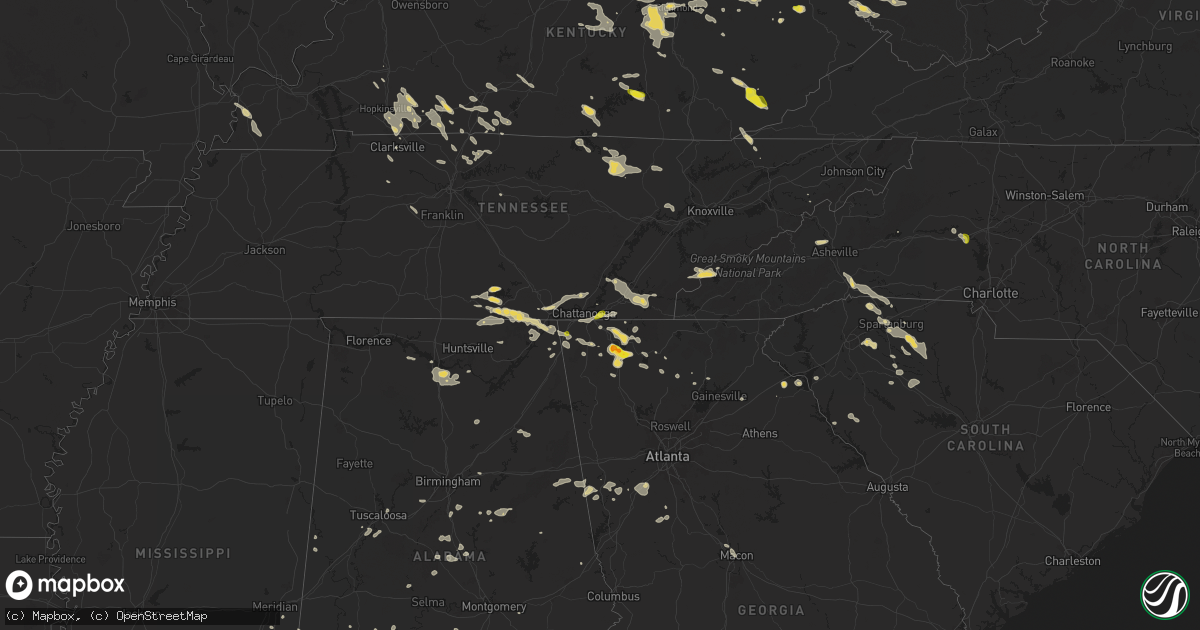
Hail Map on August 17, 2024
Get this storm
August 17 map
$229
one time, instant access
Download today. No call, no setup
Keep the $229
Bought the map and want the full workflow? Apply the entire $229 to a subscription within 7 days. None of it is wasted.
Every map, not just this one
This buys you this map. Subscription and you get every map we run, in the markets you choose from a few cities to whole states to nationwide. Plus real-time alerts the moment a storm fires.
Contact data
Name, contact info, occupancy, even credit band for addresses in the footprint. You go from where it hit to who to call.
Become the source they trust
Unlimited branding weather history reports on demand. You already have the documented answer ready for the property owner, and you are the one who showed up with it.
Property data and RoofTrace estimates
Pull up any address you have got, its value and the exact code rules for that jurisdiction, straight from One Click Code. Then RoofTrace estimates the squares, pitch, and roof value, priced the way you price.
States Impacted by Hail Map on August 17, 2024
Storm reports
Pennsylvania
| Date | Description |
|---|---|
| 08/17/20246:52 PM CDT | Multiple large tree limbs down along us-350 heading into warriors mark. Road littered with tree debris. |
| 08/17/20246:52 PM CDT | Corrects previous tstm wnd dmg report from 1 wnw warriors mark. Multiple large tree limbs down along pa-350 heading into warriors mark. Road littered with tree debris. |
| 08/17/20246:10 PM CDT | Upwards of a dozen trees down at blueberry gold course. |
| 08/17/20244:30 PM CDT | Trees down in eau claire. Time estimated via radar. |
| 08/17/20244:15 PM CDT | Large tree limbs/branches down |
| 08/17/20243:59 PM CDT | Tree and wires down. Time estimated from radar. |
| 08/17/20243:57 PM CDT | Tree down on road. Time estimated from radar. |
| 08/17/20243:47 PM CDT | Report of tree down along roadway. Time estimated based on radar. |
| 08/17/20243:45 PM CDT | Picture of trees down in avella likely associated with outflow from approaching thunderstorm. Time estimated via radar. |
| 08/17/20243:25 PM CDT | Tree down on old leechburg road in plum. Time estimated via radar. |
| 08/17/20242:35 PM CDT | Power kines down |
| 08/17/20242:20 PM CDT | A couple trees down on a private property. |
| 08/17/20241:46 PM CDT | Tree down on road and other small branches down. |
Nevada
| Date | Description |
|---|---|
| 08/17/202412:10 PM CDT | Station: mather... Id:mthn2... 9268 ft. |
Georgia
| Date | Description |
|---|---|
| 08/17/20246:55 PM CDT | Tree downed along craven road near dixson road. |
| 08/17/20246:52 PM CDT | Several trees down near hwy 60 from tomacheche trail to summit chase on price rd and southers rd. |
| 08/17/20246:50 PM CDT | Tree downed along indian creek road near lovvorn mill road. |
| 08/17/20246:35 PM CDT | Trees were reported down on ga-5 at the alabama and georgia state line. |
| 08/17/20246:30 PM CDT | Tree and powerlines downed along lee williams road. |
| 08/17/20246:15 PM CDT | A tree was down blocking one lane of hwy 82 spur at dry pond rd. |
| 08/17/20246:15 PM CDT | Multiple trees snapped near residence along june ivey road in far northern walton county. Pics included from em. |
| 08/17/20246:10 PM CDT | Tops of trees shorn off in backyard of residence near yellow river park in the 30087 zipcode of smoke rise. A few branches pierced through the wall of house. |
| 08/17/20246:10 PM CDT | A tree was downed onto power lines in the 100 block of hickory way. |
| 08/17/20246:10 PM CDT | Hart county 911 call center reports numerous trees down across the northern part of county. Time estimated from radar. |
| 08/17/20245:57 PM CDT | Tree down at whitehall rd between cagle mill rd and harris rd. |
| 08/17/20245:57 PM CDT | Tree down on gaines mill rd near eberhart cemetary rd. |
| 08/17/20245:57 PM CDT | Tree down at w county line rd near cardinal ln. |
| 08/17/20245:55 PM CDT | Several trees down in the lawson highlands area including highland rd and highland cir as well as bills cir and blueberry hills dr. |
| 08/17/20245:55 PM CDT | Tree down on building along the 600 block of fernstone trail sw. |
| 08/17/20245:47 PM CDT | Tree down along wade whelchel rd near hubert stephens rd. |
| 08/17/20245:47 PM CDT | Several trees down in the area near mt vernon rd from will wheeler rd to ben parks rd and ben lee rd. |
| 08/17/20245:46 PM CDT | Tree down along the road and on powerline near the intersection of miller rd sw and castle walk cove sw. |
| 08/17/20245:45 PM CDT | Franklin county 911 call center reported nine downed trees from franklin springs to royston with three impacting power lines. All calls came within a 10-minute window a |
| 08/17/20245:45 PM CDT | Large tree down on shallowford rd. Near the intersection of whisperwood dr. |
| 08/17/20245:45 PM CDT | Several trees down northwest of murrayville along yellow creek rd and old dahlonega hwy. |
| 08/17/20245:45 PM CDT | Large tree down on shallowford rd. Near th |
| 08/17/20245:45 PM CDT | Tree downed along old dahlonega hwy near the county line. |
| 08/17/20245:40 PM CDT | Trees down at brandy mountain rd and s chestatee st. |
| 08/17/20245:40 PM CDT | Tree on gas station at 2300 block of beaver ruin rd. |
| 08/17/20245:35 PM CDT | Tree downed along burnt stand road near glenn oaks dr. |
| 08/17/20245:30 PM CDT | Tree downed along auraria rd near burnt stand road. |
| 08/17/20245:20 PM CDT | Tree downed along ben higgins road near crooked creek dr. |
| 08/17/20245:05 PM CDT | A tree was downed at the intersection of bells ferry rd and old bascomb rd. |
| 08/17/20245:02 PM CDT | A tree was downed on fincher rd at reinhardt college pkwy. |
| 08/17/20244:55 PM CDT | Tree downed at the intersection of carlan rd and roper rd blocking lanes. |
| 08/17/20244:53 PM CDT | Corrects previous tstm wnd dmg report from 2 sse juno. Per local emc there was a broken and downed powerline along nugget ridge rd. |
| 08/17/20244:52 PM CDT | Approximately 50 trees were reported down in big canoe in the vicinity of petit ridge drive and indian pipe drive. |
| 08/17/20244:49 PM CDT | Public reports a tree down near the woodbridge inn and tavern. |
| 08/17/20244:48 PM CDT | At least eight trees down along summit dr west and summit dr east. |
| 08/17/20244:48 PM CDT | Corrects previous tstm wnd dmg report from 1 nw marblehill. Per local emc there was a broken and downed powerline along mcclain mountain rd nw of marblehill georgia. |
| 08/17/20244:33 PM CDT | Powerlines down leading to road closure along swan bridge road nw of talking rock. |
| 08/17/20244:33 PM CDT | Powerlines down leading to road closure at the intersection of swan bridge road and creek bank drive. |
| 08/17/20244:00 PM CDT | Tree limbs knocked down powerlines along rena street. |
| 08/17/20244:00 PM CDT | Tree down partially blocking john jones rd near the town of summerville. |
| 08/17/20244:00 PM CDT | Tree down along farmersville rd near the intersection of mustang dr and farmersville rd. |
| 08/17/20243:56 PM CDT | Tree down across highway 48 nw of the city of menlo. |
| 08/17/20243:56 PM CDT | Large tree down along roadway at the intersection of hemphill rd and old teloga crossroads. |
| 08/17/20243:51 PM CDT | Report from mping: ping pong ball |
| 08/17/20243:49 PM CDT | Report from mping: quarter |
| 08/17/20243:47 PM CDT | Several trees down at goswick rd and mitchell bridge rd. |
| 08/17/20243:45 PM CDT | Tree reported down across the road near the intersection of lafayette rd and mcarthur rd. |
| 08/17/20243:44 PM CDT | Tree downed along galloway road se of hwy 5. |
| 08/17/20243:44 PM CDT | Tree downed along wiggins road ne blocking both lanes. |
| 08/17/20243:40 PM CDT | Large tree blocking both lanes of traffic near the intersection of kala wy and old ringgold rd. |
| 08/17/20243:30 PM CDT | Tree reported down in the road near the int |
| 08/17/20243:30 PM CDT | Tree reported down in the road near the intersection of dawnville beaverdal rd and renfroe rd. Ne. |
| 08/17/20243:28 PM CDT | Tree reported down across the road near the intersection of mcgaughey chapel rd and wilson rd. |
| 08/17/20243:25 PM CDT | Tree down across the roadway near the intersection of meers rd and durham st. |
| 08/17/20243:15 PM CDT | Power line and transformer downed along princess drive. |
| 08/17/20242:47 PM CDT | Hail from the size of pennies to quarters was reported at the intersection of hickory street and poplar avenue. |
| 08/17/20242:38 PM CDT | Tree downed on town creek church road near the county line. |
| 08/17/20242:36 PM CDT | A tree was reported down across fuller ro |
| 08/17/20242:36 PM CDT | A tree was reported down across hartline road. |
| 08/17/20242:36 PM CDT | A tree was reported down across fuller road. |
| 08/17/20242:35 PM CDT | Tree downed on copper mines road near hide away road. |
| 08/17/20242:34 PM CDT | Tree downed on brady edge road near meadow lane. |
| 08/16/20248:57 PM CDT | Corrects previous tstm wnd dmg report from 1 wsw juliette. Tree downed along newton and juliette road. |
| 08/16/20248:57 PM CDT | Tree downed along newton and juliette road. |
| 08/16/20248:22 PM CDT | There is a tree down along brooks road. |
| 08/16/20248:13 PM CDT | Tree down at the intersection of futral road and swint rd. |
| 08/16/20248:05 PM CDT | Powerlines down along tomochichi road. |
| 08/16/20247:52 PM CDT | Tree down along jess helton rd between t martin rd and helton rd. |
| 08/16/20247:46 PM CDT | Tree downed along standing rock road and brown road. |
| 08/16/20247:45 PM CDT | Tree downed along hwy 16 and elders mill road. |
| 08/16/20247:45 PM CDT | Tree down along brown rd and hwy 16. |
| 08/16/20247:43 PM CDT | Powerlines down at the intersection of line creek and hollonville road. |
| 08/16/20247:40 PM CDT | Tree downed along ragsdale road and hwy 54. |
| 08/16/20247:32 PM CDT | Several trees were downed at the intersection of north peachtree parkway and flat creek road. |
| 08/16/20247:25 PM CDT | Tree downed along lower fayetteville and wentworth road. |
| 08/16/20247:22 PM CDT | Tree downed along e newnan road at turkey creek rd. |
| 08/16/20247:22 PM CDT | Tree downed at lower fayetteville and summergrove. |
| 08/16/20247:20 PM CDT | Tree downed at orr and tope road. |
| 08/16/20247:20 PM CDT | Tree downed along hwy 16 near george hill road. |
| 08/16/20247:20 PM CDT | Tree downed in 700 block of lower fayetteville road. |
| 08/16/20247:20 PM CDT | Tree downed in 1st block of fisher st. |
| 08/16/20247:20 PM CDT | Tree downed along hwy 16 and martin mill road. |
| 08/16/20247:20 PM CDT | Tree down at poplar road and newnan crossing. |
| 08/16/20247:20 PM CDT | Tree downed at sherwood dr and roscoe rd. |
| 08/16/20247:19 PM CDT | Tree downed on a home along e newnan road. |
| 08/16/20247:18 PM CDT | Tree downed at forest circle and shenandoah blvd. |
| 08/16/20247:17 PM CDT | Some homes and vehicles damaged from falling trees near e broad st and robinson st. |
| 08/16/20247:16 PM CDT | Tree downed at ray and annie st. |
| 08/16/20247:15 PM CDT | Wires down along booker avenue due to a fallen tree. |
| 08/16/20247:15 PM CDT | Tree downed along velma drive and lundy st. |
| 08/16/20247:15 PM CDT | Wires down along dogwood trail due to a downed tree. |
| 08/16/20247:15 PM CDT | Trees were downed across highway 29 at oaklawn circle. |
| 08/16/20247:15 PM CDT | Two power poles were snapped at the intersection of sewell rd at armory rd. |
| 08/16/20247:15 PM CDT | Tree downed on a home along oak lane. |
| 08/16/20247:15 PM CDT | Tree downed at kent dr and lakeshore pkwy. |
| 08/16/20247:15 PM CDT | Tree downed at ray st and washington st. |
| 08/16/20247:15 PM CDT | Tree on a house along east broad st. |
| 08/16/20247:15 PM CDT | Tree down along handy road and keith road. |
| 08/16/20247:15 PM CDT | Tree downed at blackberry drive and roscoe rd. |
| 08/16/20247:12 PM CDT | Tree downed in 1400 block of corinth road. |
| 08/16/20247:10 PM CDT | Tree downed along dolly nixon road and hwy 34. |
| 08/16/20247:10 PM CDT | Tree downed at w. Grantville road and bethlehem church road. |
| 08/16/20247:08 PM CDT | Trees down 2200 block of welcome road. |
| 08/16/20247:08 PM CDT | Tree downed at welcome woods dr and welcome road. |
| 08/16/20247:04 PM CDT | Tree downed along gum creek road near the county line. |
| 08/16/20247:00 PM CDT | Tree downed along glenloch road near lepard road. |
| 08/16/20247:00 PM CDT | Some trees and limbs down near moss creek dr. |
Kentucky
| Date | Description |
|---|---|
| 08/17/20246:59 PM CDT | A public report of hail was received via twitter with pictures from a location east of harlan off of ky 38 on shell hollow road also known as eubank road. |
| 08/17/20246:58 PM CDT | Numerous trees down along us 127 in the north part of the county. |
| 08/17/20246:40 PM CDT | Trained spotter shared pictures of a couple of open faced barns destroyed. Power poles were also broken which resulted in 400 power outages in the area. |
| 08/17/20246:36 PM CDT | Trees down near the intersection of plainview church road and proctor mill road. |
| 08/17/20246:34 PM CDT | A social media report of hail up to half dollar size was received with pictures. The hail fell off of us 421 at elmer lane between mozelle and helton closer to mozelle. |
| 08/17/20245:55 PM CDT | Trees down on powerlines on old state road in brandenburg. |
| 08/17/20245:23 PM CDT | A power line was reported to be hanging across the caleb fork road in the community of weeksbury due to a downed tree. Time estimated by radar. |
| 08/17/20245:15 PM CDT | A tree was downed onto hwy 122 in the hight hat community. Time estimated by radar. |
| 08/17/20245:04 PM CDT | A tree was blown down just south of ky 30 in a location about 1 road mile east of airport road. The event time is estimated from radar and nearby observations. |
| 08/17/20245:02 PM CDT | A tree was downed near mm 1 of ky-3680 in the drift community. Time estimated by radar. |
| 08/17/20244:52 PM CDT | Trees and powerlines down at the intersection of russellville road and dishman lane. |
| 08/17/20244:52 PM CDT | A telephone pole was downed by winds along cliff road in prestonsburg. Time estimated by radar. |
| 08/17/20244:50 PM CDT | A tree was downed onto a power line around 2950 arkansas creek road... Just southeast of the town of martin. Time estimated by radar. |
| 08/17/20244:45 PM CDT | Trees down on fairground rd. Time estimated from radar. |
| 08/17/20244:45 PM CDT | A tree was felled near 1090 abbott creek road. |
| 08/17/20244:42 PM CDT | Trees down on airport road near lincoln boyle county line. Time estimated from radar. |
| 08/17/20244:41 PM CDT | A tree was reported down at the 6900 block of ky-404 near the community of david. Time estimated by radar. |
| 08/17/20244:38 PM CDT | Trees down on elm street. Time estimated from radar. |
| 08/17/20244:30 PM CDT | Trees down on black pike near hustonville. Time estimated from radar. |
| 08/17/20244:25 PM CDT | Trees down on elk cave branch rd. Time estimated from radar. |
| 08/17/20244:21 PM CDT | Large healthy tree down on stamper branch rd. |
| 08/17/20244:15 PM CDT | The 911 call center received 21 reports of trees down from around the county and 2 reports of downed power lines. Most of the trees were blown down along brown ridge ro |
| 08/17/20244:11 PM CDT | Corrects time of previous tstm wnd dmg report from 1 e pitts. Delayed social media report of downed large tree branches at 3135 tipton ridge road. Time estimated via ra |
| 08/17/20244:10 PM CDT | Few trees down near ellipse street as well walnut meadow area. Very rough estimate time... With strong outflow passing through around 5 pm and a new storm moving over t |
| 08/17/20244:07 PM CDT | Tree down on vehicle along highway 715. |
| 08/17/20244:07 PM CDT | Multiple trees down along chimney top road in the red river gorge. |
| 08/17/20244:06 PM CDT | Several trees down in this area. Intersection of mitchellsburg rd and harberson ln. Bakers ln. And around the 9700 and 10300 block of lebanon rd. Also somewhere on scru |
| 08/17/20244:03 PM CDT | Twitter post with picture of tree down in richmond battlefield park. Time estimated from radar. |
| 08/17/20244:00 PM CDT | Trees down in the 4500 block of webster rd. Time estimated from radar. |
| 08/17/20243:57 PM CDT | Trees down on gillispie pike and hwy 1295. Time estimated from radar. |
| 08/17/20243:47 PM CDT | Metal siding removed from home. |
| 08/17/20243:44 PM CDT | A tree was blown down and across highway 746 in wellington. Another tree was blown down and onto a powerline on camp judy lane in wellington. |
| 08/17/20243:44 PM CDT | A tree was blown down on fletcher road off tar ridge road in frenchburg. |
| 08/17/20243:44 PM CDT | Tree down along brandy lane. Time estimated by radar. |
| 08/17/20243:44 PM CDT | Tree down along campton rd. Time estimated by radar. |
| 08/17/20243:43 PM CDT | Trees down on oscar ray as well as tommy murphy rd. Time estimated from radar. |
| 08/17/20243:42 PM CDT | Tree down along darrel randall rd. Time estimated by radar. |
| 08/17/20243:41 PM CDT | Tree down on structure. Time estimated by radar. |
| 08/17/20243:37 PM CDT | Corrects location and time of previous tstm wnd dmg report from 7 s clearfield. A tree was blown down on bangor boat dock road along cave run lake. |
| 08/17/20243:35 PM CDT | A tree was blown down east of elliottville near the elliott county line. |
| 08/17/20243:34 PM CDT | A tree was blown down at the bangor boat ramp along cave run lake 7 miles south of clearfield. |
| 08/17/20243:19 PM CDT | Twitter report of power lines snapped near the taco bell in winchester. |
| 08/17/20243:18 PM CDT | Large tree down and power lines down in mackville. |
| 08/17/20243:01 PM CDT | Large tree down across road on crawley lane. |
| 08/17/20242:58 PM CDT | A tree was blown down at 920 sunset road in hillsboro. |
| 08/17/20242:54 PM CDT | Power lines down. |
| 08/17/20242:54 PM CDT | Multiple reports of tree damage and power lines down in south lexington... Including on jairus drive. |
| 08/17/20242:50 PM CDT | Mesonet station wnch winchester 3 nw. |
| 08/17/20242:49 PM CDT | Power outage reported at a business. |
| 08/17/20242:44 PM CDT | Large tree down on clintonville rd at van meter rd. Time estimated from radar. |
| 08/17/20242:43 PM CDT | Multiple trees were blown down on praiter road in mount carmel. |
| 08/17/20242:43 PM CDT | Large tree branch snapped and fell onto a home in south lexington. |
| 08/17/20242:37 PM CDT | Estimated 50 to 60 mph winds from two different sources near the jessamine and fayette county line. |
| 08/17/20242:32 PM CDT | Asos station klex lexington. |
| 08/17/20242:25 PM CDT | Utility company reports tree down on lines along hilton branch road. Time estimated from radar. |
| 08/17/20242:25 PM CDT | Large tree limb down on vehicle in woodland park. |
| 08/17/20242:06 PM CDT | A tree was blown down on ky-557 near sandy hook. |
| 08/17/20242:05 PM CDT | Video from concord area showing numerous branches down. Time estimated from radar. |
| 08/17/20241:46 PM CDT | . |
| 08/17/20241:46 PM CDT | A local report indicates 1.00 inch wind near 1 S Oggs Station |
| 08/17/20241:38 PM CDT | Scattered minor tree damage reported in downtown frankfort and on the east side of town. Estimated 900 to 950 people without power. |
| 08/17/20241:25 PM CDT | Delayed report. Tobacco barn destroyed... Likely from a small downburst. Multiple storms went through the area that afternoon. Tcvg used to estimate timing of downburst |
| 08/17/202412:11 PM CDT | Delayed social media report of downed large tree branches at 3135 tipton ridge road. Time estimated via radar. |
| 08/16/20247:12 PM CDT | Half dollar size hail was reported via social media with pictures included. The event occurred at a residence on springs road to the southwest of somerset not far from |
Virginia
| Date | Description |
|---|---|
| 08/17/20244:04 PM CDT | Tree down near circle loop and ridge rd |
| 08/17/20243:58 PM CDT | Tree down near 9522 lambs creek church rd |
| 08/17/20243:10 PM CDT | Tree down along holly corner rd and country manor dr |
New York
| Date | Description |
|---|---|
| 08/17/20244:03 PM CDT | Large tree down on roadway. |
| 08/17/20243:01 PM CDT | Tree down on gowanda state road. |
| 08/17/20242:26 PM CDT | Tree down on road... Cable wire across road. |
| 08/17/20242:20 PM CDT | Trees down in elma. |
Oklahoma
| Date | Description |
|---|---|
| 08/17/20247:15 AM CDT | Multiple power poles snapped. Social media image. |
Wyoming
| Date | Description |
|---|---|
| 08/17/20246:53 PM CDT | Asos station krwl 1 ene rawlins. |
| 08/17/20246:20 PM CDT | Mesonet station pc454 moss rock. |
| 08/17/20246:12 PM CDT | Mesonet station krec red canyon - south pass. |
| 08/17/20246:12 PM CDT | Asos station klnd lander airport. |
| 08/17/20245:02 PM CDT | Asos station kbpi big piney airport. |
| 08/17/20245:02 PM CDT | Corrects previous non-tstm wnd gst report from 2 n marbleton. Asos station kbpi big piney airport. |
| 08/17/20244:57 PM CDT | Asos station krks rock springs airport. |
| 08/17/20243:50 PM CDT | Measured at mesonet site verne1. |
| 08/17/20242:55 PM CDT | Measured at mesonet site medicine butte. |
| 08/16/20247:53 PM CDT | Asos station klnd lander airport. |
| 08/16/20247:42 PM CDT | Mesonet station wy20 2.5 se elk mountain |
| 08/16/20247:36 PM CDT | Mesonet station wy18 halleck ridge |
| 08/16/20247:04 PM CDT | Corrects timing of previous tstm wnd gst report from 1 ssw lander. Asos station klnd lander airport. |
| 08/16/20247:04 PM CDT | Asos station klnd lander airport. |
| 08/16/20247:02 PM CDT | Mesonet station kskl skyline |
Idaho
| Date | Description |
|---|---|
| 08/17/20244:55 PM CDT | A local report indicates 58 MPH wind near Pocatello Airport |
| 08/17/20242:00 PM CDT | Itd fish creek summit. |
| 08/16/20247:30 PM CDT | Pacificorp medicine lodge. |
| 08/16/20247:30 PM CDT | Pacificorp |
Alabama
| Date | Description |
|---|---|
| 08/17/20246:34 PM CDT | Trees were blown down on sr 48 near the state line. |
| 08/17/20246:25 PM CDT | Several trees down on county rd 19 near newell. |
| 08/17/20245:45 PM CDT | Multiple trees were blown down along sr 9. |
| 08/17/20245:44 PM CDT | Tree blown down across roadway at main st. And hinds st in oxford. |
| 08/17/20245:30 PM CDT | Trees were blown down along cr 32 in eastern coosa county. |
| 08/17/20245:30 PM CDT | Multiple trees were blown down along sr 148. |
| 08/17/20245:25 PM CDT | Trees were blown down along cr 66 west of goodwater. |
| 08/17/20245:09 PM CDT | Tree blocking roadway on scott ln and possum trot rd. |
| 08/17/20244:50 PM CDT | Trees were blown down along cr 56 south of marble valley. |
| 08/17/20244:48 PM CDT | A few trees were blown down in the childersburg area. |
| 08/17/20244:42 PM CDT | Numerous trees uprooted... Power lines down... Trees on homes in the cedar creek area of lay lake. |
| 08/17/20244:40 PM CDT | Emergency management reports several trees and powerlines down from east gadsden to glencoe and hokes bluff. Sporadic reports across the rest of the county. |
| 08/17/20244:31 PM CDT | There are multiple trees and some power lines down in chelsea. |
| 08/17/20244:30 PM CDT | Trees and power were blown down on sr 25 south of harpersville. |
| 08/17/20244:27 PM CDT | Trees were blown down between moody and leeds. |
| 08/17/20244:25 PM CDT | Trees were blown down along cr 47/chelsea road. |
| 08/17/20244:22 PM CDT | Dispatch reports numerous trees and powerlines down across the county. |
| 08/17/20244:22 PM CDT | Trees were blown down and blocking the roadway on cr 143. |
| 08/17/20244:21 PM CDT | Trees down blocking the roadway on cr 43 in tuckers chapel. |
| 08/17/20244:15 PM CDT | A tree was blown down and blocking the roadway on cr 52 in tuckers chapel. |
| 08/17/20244:14 PM CDT | A tree was blown down and blocking the road on cedar street. |
| 08/17/20243:53 PM CDT | A tree was knocked down onto a home near highway 35 in the little river canyon area. More specific location not available. Time estimated by radar. |
| 08/17/20243:52 PM CDT | A tree was reported down at 1000 godfrey south in fort payne. Time estimated by radar. |
| 08/17/20243:50 PM CDT | A few trees were blown down around mccalla. |
| 08/17/20243:43 PM CDT | A tree was knocked down at 1898 cr 235 near paint rock. |
| 08/17/20243:40 PM CDT | A tree was blown down on old tuscaloosa highway. |
| 08/17/20243:36 PM CDT | A tree was blown down on grey hill road. |
| 08/17/20243:32 PM CDT | A tree was reported down at the intersection of hatton school road and east 2nd street. Time estimated by radar. |
| 08/17/20243:30 PM CDT | A tree was knocked down blocking the roadway at 16435 alabama highway 71. Time estimated by radar. |
| 08/17/20243:04 PM CDT | A tree was knocked down onto power lines at the intersection of cr 290 and cr 291. Time estimated by radar. |
| 08/17/20243:03 PM CDT | A tree was knocked down onto a power line. Time estimated by radar. |
| 08/17/20243:02 PM CDT | A tree was reported down on cr 297. Time estimated by radar. |
| 08/17/20242:59 PM CDT | A tree was knocked down blocking the roadway at gum pond road at bethel church road. Time estimated by radar. |
| 08/17/20242:49 PM CDT | Multiple trees were reported down along hobbs island road. Time estimated by radar. |
| 08/17/20242:40 PM CDT | Trees were reported down in new hope area... Some to the root ball and at least one snapped. Time estimated by radar. |
| 08/17/20242:39 PM CDT | 12 to 15 60 foot tall trees were reported to be knocked down. Some were uprooted and snapped. Location at the 9500 block of union grove road. Time estimated by radar. |
| 08/17/20242:26 PM CDT | A tree was reported down at the 3000 block of alabama highway 71. Time estimated by radar. |
| 08/17/20242:24 PM CDT | One inch diameter hail reported on deaton road. Time estimated by radar. |
| 08/17/20242:24 PM CDT | Social media photos indicated damage near the intersection of miller lane and paul drive. At this location... Several trees were uprooted... One snapped and several lar |
| 08/17/20242:08 PM CDT | A tree was knocked down into the roadway at the intersection of charest road and section mountain road. Time estimated by radar. |
| 08/17/20241:40 PM CDT | A tree was reported down in the roadway at 400 jackson street in decatur. Time estimated by radar. |
| 08/17/20241:15 PM CDT | Two to three trees were knocked... Several tents were blown down... And an inflatable slide was blown away. Exact location unknown. Time estimated by radar. |
Maryland
| Date | Description |
|---|---|
| 08/17/20244:47 PM CDT | One tree down partially blocking howard chapel rd. |
Ohio
| Date | Description |
|---|---|
| 08/17/20246:32 PM CDT | Tree and wires down. Time estimated via radar. |
| 08/17/20246:25 PM CDT | Tree fell on vehicle. Time estimated via radar. |
| 08/17/20246:22 PM CDT | Tree down on road. Time estimated from radar. |
| 08/17/20246:01 PM CDT | Corrects previous tstm wnd dmg report from 2 ne brimfield. Tree down on roadway. Time estimated from radar. |
| 08/17/20246:00 PM CDT | A couple of tree limbs downed in parma. |
| 08/17/20245:57 PM CDT | Corrects previous tstm wnd dmg report from 2 wsw brimfield. Tree down on road. Time estimated from radar. |
| 08/17/20245:53 PM CDT | A tree fell and took down power lines and a pole at the corner of norris avenue and dick street. Picture shared on social media. Time estimated from radar. |
| 08/17/20245:52 PM CDT | Tree down on roadway. Time estimated from radar. |
| 08/17/20245:45 PM CDT | Tree down on road. Time estimated from radar. |
| 08/17/20245:45 PM CDT | Numerous large limbs down... Including one fallen on a vehicle. Pictures shared via social media. Time estimated from radar. |
| 08/17/20245:45 PM CDT | Report from mping: 3-inch tree limbs broken. |
| 08/17/20245:40 PM CDT | Tree limb downed onto car and power lines. |
| 08/17/20245:22 PM CDT | A tree was reported down on route 402. |
| 08/17/20245:06 PM CDT | Tree down. Time estimated from radar. |
| 08/17/20245:05 PM CDT | Tree damage in coshocton. Time estimated via radar. |
| 08/17/20245:00 PM CDT | Siding damage from another house on northridge road. Time estimated from radar. |
| 08/17/20245:00 PM CDT | Several branches down on property at northridge road. Time estimated from radar. |
| 08/17/20244:30 PM CDT | Trees uprooted and snapped. |
| 08/17/20243:30 PM CDT | Report of trees down along roadway. Time estimated based on radar. |
| 08/17/20243:26 PM CDT | Report down at intersection of sinclair avenue and john scott highway. Time estimated based on radar. |
| 08/17/20243:25 PM CDT | A local report indicates 1.00 inch wind near E Wintersville |
| 08/17/20243:23 PM CDT | A local report indicates 1.00 inch wind near 2 W Brentwood |
| 08/17/20242:50 PM CDT | Tees down |
| 08/17/20242:40 PM CDT | Utility company reports tree down on lines along state route 683. Time estimated from radar and utility company outage report. |
| 08/17/20242:10 PM CDT | Public report of tree damage on multiple properties. Along with a downed limb... 3 whole trees came down with 1 landing on a house and one landing on the road. |
| 08/17/20242:09 PM CDT | Trees down across county road 2. Time estimated via radar. |
| 08/17/20242:07 PM CDT | Quarter size hail. |
| 08/17/20242:00 PM CDT | Large tree limbs/branches down |
| 08/17/20241:50 PM CDT | Tree down on powerlines. Powerlines caught on fire. Time estimated via radar. |
| 08/17/20241:50 PM CDT | Tree down into powerlines. Time estimated via radar. |
| 08/17/20241:46 PM CDT | Power poles and lines down - time estimated. |
| 08/17/20241:46 PM CDT | A local report indicates 1.00 inch wind near 1 N West Union |
| 08/17/20241:41 PM CDT | Multiple trees down and small hail all alonghill street and county road 55 in coshocton county |
| 08/17/20241:35 PM CDT | Trees down along old state route 32 in peebles. |
| 08/17/202412:39 PM CDT | Single tree down near kroger. Photo verified. Time estimated from radar. |
Oregon
| Date | Description |
|---|---|
| 08/17/20246:59 PM CDT | Quarter-sized hail reported by spotter ca-142 at mt. Hood village. |
| 08/17/20246:42 PM CDT | Branches of 1 in diameter breaking. Railroad crossing arm broke from wind gust. |
| 08/17/20244:55 PM CDT | A crew member on the coffee pot wildfire reported 1-inch hail. |
| 08/17/20243:20 PM CDT | Facebook post contains image of a downed tree. Narrow trunk... Maybe 4-6 inches. At least 20 feet tall. |
| 08/16/202411:02 PM CDT | A local report indicates 60 MPH wind near 1 ESE Hermiston |
| 08/16/202410:47 PM CDT | Pendleton airport. |
| 08/16/20249:45 PM CDT | A local report indicates 70 MPH wind near Arlington |
| 08/16/20249:32 PM CDT | Corrects previous tstm wnd gst report from 5 ene rufus. Odot sensor i84 eb at lepage park - john day river mp114.41. |
| 08/16/20249:30 PM CDT | Leaning juniper... Or site recorded a gust to 58 mph. |
| 08/16/20249:29 PM CDT | Odot at blalock canyon. |
| 08/16/20249:22 PM CDT | Hail slightly bigger than a quarter fell between 715 and 730 pm. Report via facebook. |
| 08/16/20248:45 PM CDT | Spotter shared images of several downed trees. Estimated trunk diameter of 4 to 6 inches. Estimated height of 20 to 30 feet. |
| 08/16/20248:30 PM CDT | Corrects previous tstm wnd dmg report from 3 wnw odell. Few downed trees... Unknown time. |
| 08/16/20247:00 PM CDT | Picture of ping pong sized hail on facebook. Time estimated from radar. |
Utah
| Date | Description |
|---|---|
| 08/17/20246:00 PM CDT | Several reports |
| 08/17/20243:15 PM CDT | Measured at mesonet site windy peak. |
| 08/17/20243:15 PM CDT | Measured at bryce canyon airport. |
| 08/17/20242:30 PM CDT | Measured at mesonet site duchesne ridge. |
| 08/17/20242:15 PM CDT | Measured at mesonet site currant creek peak. |
| 08/17/20242:10 PM CDT | Measured at udot mesonet site grassey. |
| 08/17/20241:30 PM CDT | From mesonet site apg at dugway. |
| 08/17/20241:20 PM CDT | Mesonet station dpg04 target s. |
| 08/17/20241:15 PM CDT | Mesonet station dpg31 west granite. |
| 08/17/20241:15 PM CDT | Mesonet station dpg18 causeway. |
| 08/17/20241:15 PM CDT | Mesonet station dpg02 callao gate. |
| 08/17/20241:10 PM CDT | Mesonet station dpg19 fish springs. |
| 08/17/202412:50 PM CDT | Mesonet station ut107 i-80 at mp 107. |
| 08/17/202412:36 PM CDT | Mesonet station tvwu1 tule valley. |
| 08/17/202411:50 AM CDT | Mesonet station utcir i-15 at mp 169. |
California
| Date | Description |
|---|---|
| 08/17/20243:20 PM CDT | Public shares picture of a mature tree down in back yard. This tree did not appear to be alive or healthy. No injuries or other property damage associasted with the tre |
Colorado
| Date | Description |
|---|---|
| 08/17/20243:07 PM CDT | A local report indicates 62 MPH wind near 10 NNW Vona |
Nebraska
| Date | Description |
|---|---|
| 08/17/20246:52 AM CDT | Caller relays report of multiple 6 to 8 inch branches downed in pasture 2 miles to east. Time estimated from radar. |
| 08/17/20245:24 AM CDT | Time estimated from radar. |
South Dakota
| Date | Description |
|---|---|
| 08/17/20245:06 AM CDT | Lots of hail up to the size of quarters fell for about 10 to 15 minutes... Leaving little drifts of it through 835 am. The corn in the fields is badly stripped of its l |
| 08/17/20245:02 AM CDT | Lots of quarter to smaller sized hail and heavy rain overnight. Corn is badly damaged. |
| 08/17/20244:45 AM CDT | Shingles blown off roof and 5 inch diameter tree branches broken off. |
| 08/17/20244:15 AM CDT | A local report indicates 63 MPH wind near 4 NNE Colome |
| 08/17/20243:59 AM CDT | A local report indicates 77 MPH wind near 1 NE Winner |
| 08/17/20243:15 AM CDT | Nickel to quarter size hail. Very heavy rain |
Arizona
| Date | Description |
|---|---|
| 08/17/20242:40 AM CDT | ***delayed report*** multiple downed trees around the fountain park area in fountain hills. A 61 mph gust was measured. Timing estimated from radar. |
| 08/17/20242:40 AM CDT | ***delayed report*** 100-150 downed trees reported across the tpc scottsdale golf course. Timing estimated from radar. |
| 08/17/202412:45 AM CDT | Mesonet station up550 tucson ruthrauff rd/i-10. |
North Carolina
| Date | Description |
|---|---|
| 08/17/20244:45 PM CDT | Graham county 911 call center reports numerous trees down in fontana village. Time estimated from radar. |
| 08/17/20244:05 PM CDT | 911 call centers received numerous reports of downed trees across polk county. Duke energy reports a couple hundred customers without power near white oak mountain rd i |
| 08/17/20243:56 PM CDT | Wcnc storm spotter reported 1 inch hail near claremont at time indicated. |
| 08/16/202410:25 PM CDT | The surry county 911 center reported that a tree was down along the on ramp to u.s. 52 at its intersection with south key street near pilot mountain. |
| 08/16/202410:10 PM CDT | The surry county 911 center reported that a tree was down blocking both lanes of traffic in the 100 block of dodson road in elkin nearf the welcome valley baptist churc |
| 08/16/202410:09 PM CDT | The surry county 911 center reported that a tree was down blocking both lanes of traffic near the intersection of joe layne mill road and poplar springs road in elkin. |
| 08/16/20247:12 PM CDT | County official reports a couple trees blown down on moore street. |
New Mexico
| Date | Description |
|---|---|
| 08/17/20245:34 PM CDT | Awos station kcvs cannon air force base. Caused by a thunderstorm induced microburst. |
West Virginia
| Date | Description |
|---|---|
| 08/17/20245:10 PM CDT | Tree on power line. |
| 08/17/20245:10 PM CDT | Corrects previous tstm wnd dmg report from 2 n delbarton. Tree on power line. |
| 08/17/20244:20 PM CDT | County 911 reports a tree down near the top of dingess mountain... On the mingo county side of the border. |
| 08/17/20244:10 PM CDT | Tree on power line. |
| 08/17/20244:10 PM CDT | Tree on power line. |
| 08/17/20244:07 PM CDT | County 911 reports multiple calls about trees and lines down on marrowbone creek road. Time estimated from radar. |
| 08/17/20244:04 PM CDT | Tree on power line. |
| 08/17/20243:42 PM CDT | Trees down in weirton. Time estimated via radar. |
| 08/17/20243:20 PM CDT | Tree damage and branches down across follansbee. Time estimated via radar. |
| 08/17/20242:40 PM CDT | County 911 and utility company report a tree and lines down along wv 152 near beech fork state park. |
| 08/17/20242:40 PM CDT | County 911 reports tree down on right fork wilson creek raod. Time estimated from radar. |
| 08/17/20242:03 PM CDT | Trees down in weirton with pea size hail. Time estimated via radar. |
South Carolina
| Date | Description |
|---|---|
| 08/17/20246:25 PM CDT | County official reports many trees blown down across the city of union and elsewhere throughout the county. |
| 08/17/20246:15 PM CDT | Sc highway patrol reported a tree blocking arnold branch rd near the intersection with fountain inn rd |
| 08/17/20246:00 PM CDT | Sc highway patrol reported a tree blocking the roadway at the intersection of lee vaughn rd |
| 08/17/20245:55 PM CDT | Sc highway patrol reported a tree blocking roadway on glenn springs rd |
| 08/17/20245:50 PM CDT | Spartanburg county emergency management reported a tree down on powerlines on wingo rd near cudd dr. Time estimated from radar. |
| 08/17/20245:45 PM CDT | Spartanburg county emergency management reported powerlines down at the intersection of us 221 and cleveland chapel rd. Time estimated from radar. |
| 08/17/20245:40 PM CDT | Spartanburg county emergency management reported trees and powerlines down on saxon ave... Center st... And farley ave. Time estimated from radar. |
| 08/17/20245:40 PM CDT | Spartanburg county emergency management reported a tree down at the i-26 and business i-85 interchange... Blocking the roadway. Time estimated from radar. |
| 08/17/20245:40 PM CDT | Spartanburg county emergency management reported a tree down at cleveland park and powerlines down at the intersection of sc 56 and us 221... On sc 9 near i-585... And |
| 08/17/20245:18 PM CDT | Spartanburg county emergency management reported powerlines down near the intersection of us 29 and w church st. Time estimated from radar and power outage reports. |
| 08/17/20245:18 PM CDT | Spartanburg county emergency management reported a tree down at the intersection of dan river rd and us 29. Time estimated by radar and power outage report. |
| 08/17/20245:05 PM CDT | Spartanburg county emergency manager reported three trees down in boiling springs along old furnace rd. One was reported near sandy dr... Another near cycle rd... And t |
| 08/17/20244:45 PM CDT | Spartanburg county emergency management reported two trees down near campobello... One at the intersection of sc 357 and skyline dr and the other on underwood rd just n |
| 08/16/20248:40 PM CDT | Edgefield county dispatch reported trees down along addison street in edgefield. |
| 08/16/20248:17 PM CDT | Newberry county dispatch reported multiple trees down along bush river rd near crowder rd. Time estimated by radar. |
| 08/16/20248:03 PM CDT | Sc highway patrol reported multiple trees down along monticello & kinsler rds. Time estimated by radar. |
| 08/16/20247:55 PM CDT | Sc highway patrol reported trees down along i-26 north of jalapa. |
| 08/16/20247:55 PM CDT | Trees down on golf course rd at aiton rd. |
| 08/16/20247:55 PM CDT | Newberry county sheriff reported wind damage near the intersection of beaver dam creek road and us highway 76. Damage included a tree on a house... Shaved treetops... A |
| 08/16/20247:54 PM CDT | Trees down on mckenzie rd at hwy 178s. |
| 08/16/20247:48 PM CDT | Trees down on hwy 221 @ white hall rd. |
| 08/16/20247:42 PM CDT | Trees down on powerlines at 117 holmes rd. |
| 08/16/20247:38 PM CDT | Laurens county 911 call center reported tree limbs down obstructing traffic on i-26 w. Time estimated from radar. |
| 08/16/20247:37 PM CDT | Sc highway patrol reported trees down at peak road and broad river road. |
| 08/16/20247:35 PM CDT | Sc highway patrol reported a tree down along i-26. |
| 08/16/20247:35 PM CDT | Sc highway patrol reported a tree down near highway 34 and ringer road. |
| 08/16/20247:30 PM CDT | Fairfield county dispatch reported numerous trees down and power outages all across the county. |
| 08/16/20247:10 PM CDT | Laurens county 911 call center reported tree limbs obstructing traffic on i-26 w. Time estimated from radar. |
| 08/16/20247:02 PM CDT | County official reported multiple trees blown down across the southern part of the county from starr east into honea path. Time averaged from radar. |
| 08/16/20247:02 PM CDT | County official reported multiple trees blown down across the southern part of the county from star |
Washington
| Date | Description |
|---|---|
| 08/17/202412:30 AM CDT | 795 customers without power... Via chelan pud. Cause was noted on social media as a downed tree. |
| 08/16/20248:30 PM CDT | Reported via fb. |
| 08/16/20248:30 PM CDT | Hail estimated at an inch... Was reported via facebook... At trout lake. |
| 08/16/20248:30 PM CDT | Washington fire weather employee... Reported 1inch sized hail. |
| 08/16/20248:00 PM CDT | Large tree branch around 3-4 inches down. |
Mississippi
| Date | Description |
|---|---|
| 08/17/202412:47 PM CDT | Two power poles were broken and trees were downed along lynn ray rd. |
Tennessee
| Date | Description |
|---|---|
| 08/17/20243:10 PM CDT | One tree down and power lines down in ocoee tn. Time estimated by radar. |
| 08/17/20243:10 PM CDT | Four to five trees down on etowah road or hwy 411 in benton. Time estimated from radar. |
| 08/17/20242:50 PM CDT | Power lines down southwest of soddy daisy. Time estimated from radar. Location roberts mill road and levi road. |
| 08/17/20242:50 PM CDT | Trees down on blue springs road near hungry hollow road. Trees down on dalton pike hwy 60 in the flint springs area. Time estimated from radar. |
| 08/17/20242:40 PM CDT | Trees down in the walden and fairmont area. Time estimated from radar. |
| 08/17/20242:36 PM CDT | Trees down in the lone oak area. Time estimated from radar. |
| 08/17/20242:33 PM CDT | Trees were reported down in sherwood. Time estimated by radar. |
| 08/17/20242:33 PM CDT | Two trees were reported down blocking a lane of tn highway 56 near the railroad tracks. In sherwood. Time estimated by radar. |
| 08/17/20242:30 PM CDT | Social media report of quarter sized hail in east brainerd. Time estimated from radar. |
| 08/17/20242:30 PM CDT | Trees down in the whitwell area. Time estimated from radar. |
| 08/17/20242:26 PM CDT | Trees were reported down on spring creek road. Time estimated by radar. |
| 08/17/20242:20 PM CDT | Trees down in the jasper area and elsewhere in the county. |
| 08/17/20242:18 PM CDT | Trees were reported down on rock creek road. Time estimated by radar. |
| 08/17/20242:17 PM CDT | Trees were reported down on highway 130. Time estimated by radar. |
| 08/17/20242:10 PM CDT | Trees down in jasper highlands community. Time estimated from radar. |
| 08/17/20242:08 PM CDT | A tree was reported down at 216 ashley road. Time estimated by radar. |
| 08/17/20242:05 PM CDT | Power poles down on rossville blvd. Location approximate from dispatch. |
| 08/17/202412:09 AM CDT | Mcghee tyson airport |
| 08/16/202411:13 PM CDT | Facebook report of a tree down blocking chester rd at birch bark dr. |
| 08/16/202410:15 PM CDT | Tspotter report of trees down on juarez dr in hermitage. |
| 08/16/202410:05 PM CDT | Tree snapped blocking 7th ave n behind the farmers market. |
| 08/16/20249:51 PM CDT | Tree down on house in the 1600 block of martin chapel rd. No injuries but minor damage to house. |
| 08/16/20249:31 PM CDT | Facebook photos show roof damage to a building at the clarksville speedway. |
| 08/16/20249:30 PM CDT | Social media reports of several trees down and minor roof damage to homes in the i-24 exit 1 and tiny town road areas. |
| 08/16/20248:25 PM CDT | 911 call center received 3 calls of downed trees as well as sporadic reports of power outages across the county. Time estimated by radar. |
| 08/16/20248:15 PM CDT | Social media report of trees and powerlines down in the western portion of the county; time is estimated from radar. |
| 08/16/20247:45 PM CDT | Several trees were blown down along pickett park hwy. |
| 08/16/20247:18 PM CDT | Trees down on beatty creek road. |
Cities Impacted by Hail Map on August 17, 2024
- Sugar Grove, IL
- Aurora, IL
- Batavia, IL
- West Chicago, IL
- North Aurora, IL
- Geneva, IL
- Warrenville, IL
- Winfield, IL
- Carol Stream, IL
- Mooseheart, IL
- Wheaton, IL
- Addison, IL
- Glen Ellyn, IL
- Villa Park, IL
- Glendale Heights, IL
- Lombard, IL
- Elmhurst, IL
- Hillside, IL
- Berkeley, IL
- Naperville, IL
- Oak Brook, IL
- Lisle, IL
- Downers Grove, IL
- Westmont, IL
- Elkins, AR
- Picher, OK
- Tiff City, MO
- Miami, OK
- Centerton, AR
- Thayer, KS
- Galesburg, KS
- Fayetteville, AR
- Noel, MO
- Decatur, AR
- Erie, KS
- Buffalo, KS
- Benedict, KS
- Parsons, KS
- Cave Springs, AR
- Chanute, KS
- Wyandotte, OK
- Lowell, AR
- Bella Vista, AR
- Altoona, KS
- Treece, KS
- Anderson, MO
- Lincoln, AR
- Gravette, AR
- West Fork, AR
- Columbus, KS
- Seneca, MO
- Baxter Springs, KS
- Sulphur Springs, AR
- McCune, KS
- Saint Paul, KS
- Chetopa, KS
- Siloam Springs, AR
- Bartlett, KS
- Rogers, AR
- Prairie Grove, AR
- Commerce, OK
- Lanagan, MO
- Quapaw, OK
- Altamont, KS
- Gentry, AR
- South West City, MO
- Bentonville, AR
- Yates Center, KS
- Farmington, AR
- Dennis, KS
- Springdale, AR
- Goodman, MO
- Hiwasse, AR
- Oswego, KS
- Pineville, MO
- Winslow, AR
- Birch Tree, MO
- Winona, MO
- Ada, OK
- Muskogee, OK
- Vanceburg, KY
- De Mossville, KY
- Butler, KY
- Ord, NE
- Dunning, NE
- North Loup, NE
- Foster, KY
- Williamsburg, OH
- Mount Orab, OH
- Bethel, OH
- New Richmond, OH
- Moscow, OH
- Fayetteville, OH
- Scotia, NE
- Oakland, KY
- Bowling Green, KY
- Falmouth, KY
- Ellisville, MS
- Wolbach, NE
- Hillsboro, AL
- Felicity, OH
- Georgetown, OH
- Palmer, NE
- Brooksville, KY
- Frankfort, KY
- Hayneville, AL
- Aliceville, AL
- Augusta, KY
- Nashport, OH
- Hurricane, UT
- Butler, AL
- Fort Deposit, AL
- Minter, AL
- Fullerton, NE
- Belgrade, NE
- Winchester, OH
- Dover, KY
- Ripley, OH
- Russellville, OH
- Mount Sterling, KY
- Shelbyville, KY
- Waddy, KY
- Pine Apple, AL
- Jeffersonville, KY
- Frazeysburg, OH
- Belvidere, TN
- Mulberry, TN
- Winchester, TN
- Sherwood, TN
- Stevenson, AL
- Decatur, AL
- Toxey, AL
- Clarks, NE
- Cynthiana, KY
- Cadiz, OH
- West Union, OH
- Manchester, OH
- Aberdeen, OH
- Maysville, KY
- Kelso, TN
- Seaman, OH
- South Pittsburg, TN
- Meridian, MS
- Dillonvale, OH
- Adena, OH
- Seminary, MS
- Fayetteville, TN
- Germantown, KY
- Means, KY
- Paris, KY
- Bridgeport, AL
- Hartselle, AL
- Somerville, AL
- Peebles, OH
- Cecil, AL
- Mount Olivet, KY
- Carlisle, KY
- Northfield, OH
- Solon, OH
- Bedford, OH
- Shubuta, MS
- Loudonville, OH
- Perrysville, OH
- West Liberty, KY
- Sandy Hook, KY
- Clearfield, KY
- Morehead, KY
- Smithfield, OH
- Rayland, OH
- Mingo Junction, OH
- Lookout Mountain, GA
- Blue Creek, OH
- Lynx, OH
- Huntland, TN
- Elora, TN
- Flintville, TN
- Olive Hill, KY
- Stockton, NY
- Alton, UT
- Lynchburg, TN
- Shreve, OH
- Jeromesville, OH
- Wooster, OH
- Zanesville, OH
- Quitman, MS
- Stout, OH
- Wallingford, KY
- Chagrin Falls, OH
- Chattanooga, TN
- Flintstone, GA
- Rossville, GA
- Lookout Mountain, TN
- Moselle, MS
- Colliers, WV
- Wellsburg, WV
- Follansbee, WV
- Lawrenceburg, KY
- Mayslick, KY
- Tullahoma, TN
- Versailles, KY
- Salvisa, KY
- Sequatchie, TN
- Jasper, TN
- Flemingsburg, KY
- Cassadaga, NY
- Avella, PA
- Burgettstown, PA
- Tollesboro, KY
- Laceys Spring, AL
- Taylorsville, KY
- Mount Eden, KY
- Apison, TN
- Sweet Water, AL
- Estill Springs, TN
- Fosters, AL
- Falkville, AL
- Whitwell, TN
- Tracy City, TN
- Springboro, PA
- Bryant, AL
- Flat Rock, AL
- Sandyville, OH
- East Sparta, OH
- Ralph, AL
- Jackson, AL
- Grove Hill, AL
- Waynesburg, OH
- Magnolia, OH
- Frisco City, AL
- Lexington, KY
- Vossburg, MS
- Paulding, MS
- Kimbolton, OH
- Chillicothe, OH
- Ooltewah, TN
- Signal Mountain, TN
- Moundville, AL
- Union Grove, AL
- Nicholasville, KY
- Cambridge, OH
- Moorefield, KY
- Sharpsburg, KY
- Panguitch, UT
- Fort Oglethorpe, GA
- Cleveland, TN
- McDonald, TN
- Owingsville, KY
- Ray, OH
- Winchester, KY
- Richmond, KY
- Freeport, OH
- Midway, KY
- Wagarville, AL
- Charleston, TN
- Bloomingdale, OH
- Pine Hill, AL
- Tuscaloosa, AL
- Port Washington, OH
- Cottondale, AL
- Elkfork, KY
- Hollytree, AL
- Birchwood, TN
- Soddy Daisy, TN
- Trenton, GA
- Hillsboro, KY
- Thomaston, AL
- Arlington, AL
- Crandall, GA
- New Market, AL
- Springfield, KY
- Cisco, GA
- Chatsworth, GA
- Hollywood, AL
- Georgetown, TN
- Old Fort, TN
- Leroy, AL
- Ocoee, TN
- Benton, TN
- Uriah, AL
- Rising Fawn, GA
- Georgetown, KY
- Catherine, AL
- Wilmore, KY
- Hopedale, OH
- Hazel Green, AL
- Cusseta, AL
- Sale Creek, TN
- Ringgold, GA
- Cohutta, GA
- Tunnel Hill, GA
- Delano, TN
- Jewett, OH
- Alberta, AL
- Dalton, GA
- Wildwood, GA
- Seibert, CO
- Oil City, PA
- Heidelberg, MS
- Steubenville, OH
- Reliance, TN
- Titusville, PA
- Eva, AL
- Chickamauga, GA
- Lancaster, KY
- Macon, GA
- Camden, AL
- Higdon, AL
- Grove City, PA
- Volant, PA
- Mercer, PA
- Estillfork, AL
- Silver Creek, MS
- Vona, CO
- Stratton, CO
- La Fayette, GA
- Rocky Face, GA
- Weirton, WV
- Rock Spring, GA
- Mackville, KY
- Hendersonville, NC
- McCalla, AL
- Brookwood, AL
- Bessemer, AL
- Slippery Rock, PA
- Henagar, AL
- Wolf Creek, OR
- Menlo, GA
- Salt Lick, KY
- Ider, AL
- Cooperstown, PA
- Sonoita, AZ
- Opp, AL
- Olympia, KY
- Frenchburg, KY
- Flat Rock, NC
- Mount Vernon, AL
- Montevallo, AL
- Randolph, AL
- Portersville, PA
- Blountsville, AL
- Oneonta, AL
- McIntosh, AL
- Clay City, KY
- Stanton, KY
- Denniston, KY
- Wellington, KY
- Conover, NC
- Waco, KY
- Irvine, KY
- Perryville, KY
- Gravel Switch, KY
- Abbeville, GA
- Chunchula, AL
- Claremont, NC
- Wilsondale, WV
- Kermit, WV
- Crum, WV
- Lebanon, KY
- Loretto, KY
- Le Roy, NY
- Heber City, UT
- Kamas, UT
- Mountain Home, UT
- Tabiona, UT
- Roosevelt, UT
- Fruitland, UT
- Hanna, UT
- Evanston, WY
- Coalville, UT
- Woodruff, UT
- Tropic, UT
- Bryce, UT
- Escalante, UT
- Saluda, NC
- Hydetown, PA
- Sugar Valley, GA
- Calhoun, GA
- Resaca, GA
- Catawba, NC
- Centerville, PA
- Townville, PA
- Calera, AL
- Jemison, AL
- Brierfield, AL
- Breeden, WV
- Hickory, NC
- Summerville, GA
- Marion, AL
- Paint Lick, KY
- Ezel, KY
- Campton, KY
- Slade, KY
- Alabaster, AL
- Dingess, WV
- Salyersville, KY
- Hagerhill, KY
- Lucedale, MS
- Crab Orchard, KY
- Talking Rock, GA
- Ranger, GA
- Monticello, MS
- Jayess, MS
- Ruth, MS
- Chapmanville, WV
- Vail, AZ
- Chelsea, AL
- Alexandria, OH
- Johnstown, OH
- Pataskala, OH
- Eight Mile, AL
- Bogue Chitto, MS
- Clanton, AL
- Angie, LA
- Hazel Green, KY
- Saraland, AL
- Saint Louisville, OH
- Utica, OH
- Tryon, NC
- Columbus, NC
- Maplesville, AL
- Thorsby, AL
- Bethany, WV
- Brilliant, OH
- Parksville, KY
- Bradfordsville, KY
- Ellijay, GA
- Berea, KY
- Newton, NC
- Maiden, NC
- Logan, WV
- Coshocton, OH
- Harrodsburg, KY
- Plantersville, AL
- Bardwell, KY
- Sugar Grove, PA
- Warren, PA
- Russell, PA
- Granville, OH
- Robbinsville, NC
- Gadsden, AL
- Landrum, SC
- Colorado City, AZ
- Lenore, WV
- Lovely, KY
- Williamson, WV
- Campobello, SC
- Warsaw, OH
- Tellico Plains, TN
- Hickory, PA
- Arlington, KY
- Holden, WV
- Paducah, TX
- Stanford, KY
- Bethune, CO
- Clinton, KY
- Delbarton, WV
- Oakridge, OR
- Rockfield, KY
- Inman, SC
- Sylacauga, AL
- Childersburg, AL
- Ravenna, OH
- Pavilion, NY
- Talladega, AL
- Alpine, AL
- Jasper, GA
- Cokeville, WY
- Fort Bridger, WY
- Diamondville, WY
- Granger, WY
- Opal, WY
- McKinnon, WY
- Green River, WY
- Kemmerer, WY
- Mountain View, WY
- Lyman, WY
- Robertson, WY
- La Barge, WY
- Big Piney, WY
- Boulder, WY
- Pinedale, WY
- Bondurant, WY
- Daniel, WY
- Rock Springs, WY
- Cora, WY
- Farson, WY
- Superior, WY
- Reliance, WY
- Lander, WY
- Churchville, NY
- Chesnee, SC
- Ravenna, KY
- Prestonsburg, KY
- Akron, OH
- Brodhead, KY
- Isonville, KY
- Belfry, KY
- Mount Vernon, KY
- Mize, KY
- Burlington, CO
- Idanha, OR
- Bear Lake, PA
- Spartanburg, SC
- Canal Fulton, OH
- Clinton, OH
- Kent, OH
- Matewan, WV
- Wingo, KY
- Cannon Afb, NM
- Clovis, NM
- Uniontown, OH
- Marble Hill, GA
- Dawsonville, GA
- Tumacacori, AZ
- Liberty, MS
- Una, SC
- Tucson, AZ
- Youngsville, PA
- Man, WV
- Stollings, WV
- Yolyn, WV
- Lyburn, WV
- Switzer, WV
- Manchester, KY
- Twinsburg, OH
- Amherstdale, WV
- Jonesville, SC
- Pacolet, SC
- Canon, GA
- Roebuck, SC
- Arcadia, SC
- Trinity Center, CA
- Bowersville, GA
- Lavonia, GA
- Pauline, SC
- Russellville, KY
- Lewisburg, KY
- Grayson, LA
- Hartwell, GA
- Rousseau, KY
- Tallmadge, OH
- Cottonwood, CA
- Red Bluff, CA
- Riverton, WY
- Arapahoe, WY
- Fort Washakie, WY
- Hudson, WY
- Jeffrey City, WY
- Wamsutter, WY
- Bairoil, WY
- Crowheart, WY
- Kinnear, WY
- Dubois, WY
- Auburn, KY
- Wellford, SC
- Heflin, AL
- Ranburne, AL
- Big Creek, KY
- Union, SC
- Jackson, KY
- Buffalo, SC
- Bloomfield, KY
- Coxs Creek, KY
- Estacada, OR
- Saint George, UT
- Snyder, TX
- Cuyahoga Falls, OH
- Lakemore, OH
- Graham, AL
- Helton, KY
- Bledsoe, KY
- Burkesville, KY
- Picayune, MS
- Cave City, KY
- Atmore, AL
- Century, FL
- Dahlonega, GA
- Roark, KY
- Essie, KY
- Woodland, AL
- Redding, CA
- Anderson, CA
- Lakehead, CA
- Simpsonville, SC
- Sandy, OR
- Beattyville, KY
- Hammond, LA
- Tickfaw, LA
- Russell Springs, KY
- Nancy, KY
- Sells, AZ
- Jamestown, KY
- Moore, SC
- Bush, LA
- Bogalusa, LA
- Albany, KY
- Glasgow, KY
- Park City, KY
- Bowdon, GA
- Roopville, GA
- Woodruff, SC
- Fountain Inn, SC
- Ponchatoula, LA
- Science Hill, KY
- Brightwood, OR
- Welches, OR
- Rhododendron, OR
- Government Camp, OR
- Rawlins, WY
- Saratoga, WY
- Encampment, WY
- Savery, WY
- Baggs, WY
- Dixon, WY
- Wellsville, OH
- Pine Valley, UT
- Irving, NY
- Windsor, KY
- Monticello, KY
- Springfield, LA
- Scottsville, KY
- Byrdstown, TN
- Maysville, GA
- Hammondsville, OH
- Greer, SC
- Franklin, GA
- Daviston, AL
- Alexander City, AL
- Enoree, SC
- Whitmire, SC
- Anderson, SC
- Bronston, KY
- Somerset, KY
- Adolphus, KY
- Allons, TN
- Stanton, AL
- Clinton, SC
- Morganton, NC
- Monroe, TN
- Columbus, PA
- Lawley, AL
- Braddock, PA
- Pittsburgh, PA
- Hanna, WY
- Sinclair, WY
- Rock River, WY
- Laramie, WY
- Centennial, WY
- Bosler, WY
- Elk Mountain, WY
- Buford, WY
- Jelm, WY
- Rainbow City, AL
- Madras, OR
- Warm Springs, OR
- Middlesboro, KY
- Sharpsburg, GA
- Tyrone, GA
- Palmetto, GA
- Odenville, AL
- Moody, AL
- Port Allegany, PA
- Shinglehouse, PA
- Maupin, OR
- Detroit, OR
- Kinards, SC
- Petersburg, PA
- Hopkinsville, KY
- Elkton, KY
- Harrogate, TN
- Ewing, VA
- Abbeville, SC
- Bradley, SC
- Delta, AL
- Newnan, GA
- Calhoun Falls, SC
- Mount Carmel, SC
- Stevenson, WA
- Conneaut Lake, PA
- Linesville, PA
- Jamestown, TN
- Pall Mall, TN
- Tazewell, TN
- Williamson, GA
- Griffin, GA
- Huntingdon, PA
- Concord, GA
- Crofton, KY
- Dawson Springs, KY
- Olmstead, KY
- Fillmore, UT
- Sneedville, TN
- Dufur, OR
- Baton Rouge, LA
- Saint Gabriel, LA
- Sharon Grove, KY
- Alexandria, PA
- Alvaton, KY
- Shaniko, OR
- Adairville, KY
- Talent, OR
- Medford, OR
- Woodburn, KY
- The Dalles, OR
- Franklin, KY
- Trenton, KY
- Pembroke, KY
- Wilder, TN
- Thorn Hill, TN
- Kentwood, LA
- Mozelle, KY
- Carrollton, GA
- Newberry, SC
- Randle, WA
- Morton, WA
- Linwood, NY
- Caledonia, NY
- Piffard, NY
- Phoenix, OR
- Whitesburg, GA
- Allensville, KY
- Guthrie, KY
- White Salmon, WA
- Trout Lake, WA
- Warbranch, KY
- Stinnett, KY
- Hyden, KY
- Jena, LA
- Centerville, WA
- Wishram, WA
- Wasco, OR
- Portland, TN
- Oak Grove, KY
- Marshall, NC
- Leicester, NC
- Alexander, NC
- Peachtree City, GA
- Springfield, TN
- White House, TN
- Grass Valley, OR
- Kent, OR
- Moro, OR
- Arlington, OR
- Condon, OR
- Wendover, UT
- Bethpage, TN
- Gallatin, TN
- Baxter, KY
- Cross Plains, TN
- Allardt, TN
- Roosevelt, WA
- Rufus, OR
- Goldendale, WA
- Bickleton, WA
- Willcox, AZ
- Hendersonville, TN
- Cottontown, TN
- Robbins, TN
- Sunbright, TN
- Clarksville, TN
- Greenbrier, TN
- Goodlettsville, TN
- Joelton, TN
- Mount Hood Parkdale, OR
- Glens Fork, KY
- Westmoreland, TN
- Rio Rico, AZ
- Rogers, KY
- Lewistown, PA
- Vanleer, TN
- Huntsville, TN
- Enumclaw, WA
- Lebanon, TN
- Walhonding, OH
- Cunningham, TN
- Palmyra, TN
- Buckley, WA
- Watertown, TN
- Wellsville, NY
- Whitesville, NY
- Andover, NY
- Deer Lodge, TN
- Dugway, UT
- Oliver Springs, TN
- Harriman, TN
- Fairview, TN
- Bon Aqua, TN
- Oak Ridge, TN
- Dalton, NY
- Swain, NY
- Greeneville, TN
- Pendleton, OR
- Plymouth, WA
- Umatilla, OR
- Prosser, WA
- Mabton, WA
- Helix, OR
- Boardman, OR
- Stanfield, OR
- Irrigon, OR
- Kennewick, WA
- Hermiston, OR
- Heppner, OR
- Lexington, OR
- Ione, OR
- Pilot Rock, OR
- Echo, OR
- Parkers Lake, KY
- Dunnville, KY
- Harlan, KY
- Oneida, KY
- Richmond, OH
- Greeley, NE
- Fort Mcdowell, AZ
- Okaton, SD
- Murdo, SD
- Midland, SD
- Draper, SD
- Milesville, SD
- Vivian, SD
- Hayes, SD
- Fort Pierre, SD
- Presho, SD
- Ideal, SD
- Winner, SD
- Witten, SD
- Dallas, SD
- Tryon, NE
- Colome, SD
- Wood, SD
- Gregory, SD
- Burke, SD
- Herrick, SD
- Mills, NE
- Naper, NE
- Atkinson, NE
- Stuart, NE
- Emmet, NE
- Oneill, NE
- Newport, NE
- Chambers, NE
- Ewing, NE
- Inman, NE