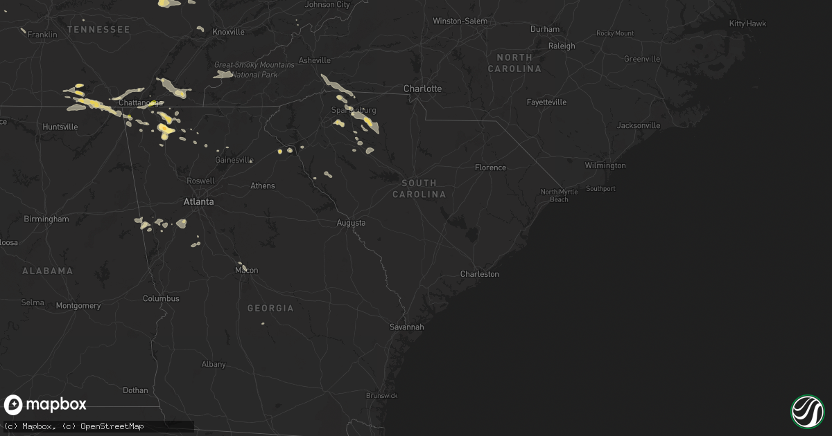
Hail Map in South Carolina on August 17, 2024
Get this storm
August 17 map
$229
one time, instant access
Download today. No call, no setup
Keep the $229
Bought the map and want the full workflow? Apply the entire $229 to a subscription within 7 days. None of it is wasted.
Every map, not just this one
This buys you this map. Subscription and you get every map we run, in the markets you choose from a few cities to whole states to nationwide. Plus real-time alerts the moment a storm fires.
Contact data
Name, contact info, occupancy, even credit band for addresses in the footprint. You go from where it hit to who to call.
Become the source they trust
Unlimited branding weather history reports on demand. You already have the documented answer ready for the property owner, and you are the one who showed up with it.
Property data and RoofTrace estimates
Pull up any address you have got, its value and the exact code rules for that jurisdiction, straight from One Click Code. Then RoofTrace estimates the squares, pitch, and roof value, priced the way you price.
Storm reports in South Carolina
South Carolina
| Date | Description |
|---|---|
| 08/17/20246:25 PM CDT | County official reports many trees blown down across the city of union and elsewhere throughout the county. |
| 08/17/20246:15 PM CDT | Sc highway patrol reported a tree blocking arnold branch rd near the intersection with fountain inn rd |
| 08/17/20246:00 PM CDT | Sc highway patrol reported a tree blocking the roadway at the intersection of lee vaughn rd |
| 08/17/20245:55 PM CDT | Sc highway patrol reported a tree blocking roadway on glenn springs rd |
| 08/17/20245:50 PM CDT | Spartanburg county emergency management reported a tree down on powerlines on wingo rd near cudd dr. Time estimated from radar. |
| 08/17/20245:45 PM CDT | Spartanburg county emergency management reported powerlines down at the intersection of us 221 and cleveland chapel rd. Time estimated from radar. |
| 08/17/20245:40 PM CDT | Spartanburg county emergency management reported a tree down at cleveland park and powerlines down at the intersection of sc 56 and us 221... On sc 9 near i-585... And |
| 08/17/20245:40 PM CDT | Spartanburg county emergency management reported a tree down at the i-26 and business i-85 interchange... Blocking the roadway. Time estimated from radar. |
| 08/17/20245:40 PM CDT | Spartanburg county emergency management reported trees and powerlines down on saxon ave... Center st... And farley ave. Time estimated from radar. |
| 08/17/20245:18 PM CDT | Spartanburg county emergency management reported powerlines down near the intersection of us 29 and w church st. Time estimated from radar and power outage reports. |
| 08/17/20245:18 PM CDT | Spartanburg county emergency management reported a tree down at the intersection of dan river rd and us 29. Time estimated by radar and power outage report. |
| 08/17/20245:05 PM CDT | Spartanburg county emergency manager reported three trees down in boiling springs along old furnace rd. One was reported near sandy dr... Another near cycle rd... And t |
| 08/17/20244:45 PM CDT | Spartanburg county emergency management reported two trees down near campobello... One at the intersection of sc 357 and skyline dr and the other on underwood rd just n |
| 08/16/20248:40 PM CDT | Edgefield county dispatch reported trees down along addison street in edgefield. |
| 08/16/20248:17 PM CDT | Newberry county dispatch reported multiple trees down along bush river rd near crowder rd. Time estimated by radar. |
| 08/16/20248:03 PM CDT | Sc highway patrol reported multiple trees down along monticello & kinsler rds. Time estimated by radar. |
| 08/16/20247:55 PM CDT | Trees down on golf course rd at aiton rd. |
| 08/16/20247:55 PM CDT | Sc highway patrol reported trees down along i-26 north of jalapa. |
| 08/16/20247:55 PM CDT | Newberry county sheriff reported wind damage near the intersection of beaver dam creek road and us highway 76. Damage included a tree on a house... Shaved treetops... A |
| 08/16/20247:54 PM CDT | Trees down on mckenzie rd at hwy 178s. |
| 08/16/20247:48 PM CDT | Trees down on hwy 221 @ white hall rd. |
| 08/16/20247:42 PM CDT | Trees down on powerlines at 117 holmes rd. |
| 08/16/20247:38 PM CDT | Laurens county 911 call center reported tree limbs down obstructing traffic on i-26 w. Time estimated from radar. |
| 08/16/20247:37 PM CDT | Sc highway patrol reported trees down at peak road and broad river road. |
| 08/16/20247:35 PM CDT | Sc highway patrol reported a tree down near highway 34 and ringer road. |
| 08/16/20247:35 PM CDT | Sc highway patrol reported a tree down along i-26. |
| 08/16/20247:30 PM CDT | Fairfield county dispatch reported numerous trees down and power outages all across the county. |
| 08/16/20247:10 PM CDT | Laurens county 911 call center reported tree limbs obstructing traffic on i-26 w. Time estimated from radar. |
| 08/16/20247:02 PM CDT | County official reported multiple trees blown down across the southern part of the county from star |
| 08/16/20247:02 PM CDT | County official reported multiple trees blown down across the southern part of the county from starr east into honea path. Time averaged from radar. |
All States Impacted by Hail Map on August 17, 2024
Cities Impacted by Hail Map on August 17, 2024
- Sugar Grove, IL
- Aurora, IL
- Batavia, IL
- West Chicago, IL
- North Aurora, IL
- Geneva, IL
- Warrenville, IL
- Winfield, IL
- Carol Stream, IL
- Mooseheart, IL
- Wheaton, IL
- Addison, IL
- Glen Ellyn, IL
- Villa Park, IL
- Glendale Heights, IL
- Lombard, IL
- Elmhurst, IL
- Hillside, IL
- Berkeley, IL
- Naperville, IL
- Oak Brook, IL
- Lisle, IL
- Downers Grove, IL
- Westmont, IL
- Elkins, AR
- Picher, OK
- Tiff City, MO
- Miami, OK
- Centerton, AR
- Thayer, KS
- Galesburg, KS
- Fayetteville, AR
- Noel, MO
- Decatur, AR
- Erie, KS
- Buffalo, KS
- Benedict, KS
- Parsons, KS
- Cave Springs, AR
- Chanute, KS
- Wyandotte, OK
- Lowell, AR
- Bella Vista, AR
- Altoona, KS
- Treece, KS
- Anderson, MO
- Lincoln, AR
- Gravette, AR
- West Fork, AR
- Columbus, KS
- Seneca, MO
- Baxter Springs, KS
- Sulphur Springs, AR
- McCune, KS
- Saint Paul, KS
- Chetopa, KS
- Siloam Springs, AR
- Bartlett, KS
- Rogers, AR
- Prairie Grove, AR
- Commerce, OK
- Lanagan, MO
- Quapaw, OK
- Altamont, KS
- Gentry, AR
- South West City, MO
- Bentonville, AR
- Yates Center, KS
- Farmington, AR
- Dennis, KS
- Springdale, AR
- Goodman, MO
- Hiwasse, AR
- Oswego, KS
- Pineville, MO
- Winslow, AR
- Birch Tree, MO
- Winona, MO
- Ada, OK
- Muskogee, OK
- Vanceburg, KY
- De Mossville, KY
- Butler, KY
- Ord, NE
- Dunning, NE
- North Loup, NE
- Foster, KY
- Williamsburg, OH
- Mount Orab, OH
- Bethel, OH
- New Richmond, OH
- Moscow, OH
- Fayetteville, OH
- Scotia, NE
- Oakland, KY
- Bowling Green, KY
- Falmouth, KY
- Ellisville, MS
- Wolbach, NE
- Hillsboro, AL
- Felicity, OH
- Georgetown, OH
- Palmer, NE
- Brooksville, KY
- Frankfort, KY
- Hayneville, AL
- Aliceville, AL
- Augusta, KY
- Nashport, OH
- Hurricane, UT
- Butler, AL
- Fort Deposit, AL
- Minter, AL
- Fullerton, NE
- Belgrade, NE
- Winchester, OH
- Dover, KY
- Ripley, OH
- Russellville, OH
- Mount Sterling, KY
- Shelbyville, KY
- Waddy, KY
- Pine Apple, AL
- Jeffersonville, KY
- Frazeysburg, OH
- Belvidere, TN
- Mulberry, TN
- Winchester, TN
- Sherwood, TN
- Stevenson, AL
- Decatur, AL
- Toxey, AL
- Clarks, NE
- Cynthiana, KY
- Cadiz, OH
- West Union, OH
- Manchester, OH
- Aberdeen, OH
- Maysville, KY
- Kelso, TN
- Seaman, OH
- South Pittsburg, TN
- Meridian, MS
- Dillonvale, OH
- Adena, OH
- Seminary, MS
- Fayetteville, TN
- Germantown, KY
- Means, KY
- Paris, KY
- Bridgeport, AL
- Hartselle, AL
- Somerville, AL
- Peebles, OH
- Cecil, AL
- Mount Olivet, KY
- Carlisle, KY
- Northfield, OH
- Solon, OH
- Bedford, OH
- Shubuta, MS
- Loudonville, OH
- Perrysville, OH
- West Liberty, KY
- Sandy Hook, KY
- Clearfield, KY
- Morehead, KY
- Smithfield, OH
- Rayland, OH
- Mingo Junction, OH
- Lookout Mountain, GA
- Blue Creek, OH
- Lynx, OH
- Huntland, TN
- Elora, TN
- Flintville, TN
- Olive Hill, KY
- Stockton, NY
- Alton, UT
- Lynchburg, TN
- Shreve, OH
- Jeromesville, OH
- Wooster, OH
- Zanesville, OH
- Quitman, MS
- Stout, OH
- Wallingford, KY
- Chagrin Falls, OH
- Chattanooga, TN
- Flintstone, GA
- Rossville, GA
- Lookout Mountain, TN
- Moselle, MS
- Colliers, WV
- Wellsburg, WV
- Follansbee, WV
- Lawrenceburg, KY
- Mayslick, KY
- Tullahoma, TN
- Versailles, KY
- Salvisa, KY
- Sequatchie, TN
- Jasper, TN
- Flemingsburg, KY
- Cassadaga, NY
- Avella, PA
- Burgettstown, PA
- Tollesboro, KY
- Laceys Spring, AL
- Taylorsville, KY
- Mount Eden, KY
- Apison, TN
- Sweet Water, AL
- Estill Springs, TN
- Fosters, AL
- Falkville, AL
- Whitwell, TN
- Tracy City, TN
- Springboro, PA
- Bryant, AL
- Flat Rock, AL
- Sandyville, OH
- East Sparta, OH
- Ralph, AL
- Jackson, AL
- Grove Hill, AL
- Waynesburg, OH
- Magnolia, OH
- Frisco City, AL
- Lexington, KY
- Vossburg, MS
- Paulding, MS
- Kimbolton, OH
- Chillicothe, OH
- Ooltewah, TN
- Signal Mountain, TN
- Moundville, AL
- Union Grove, AL
- Nicholasville, KY
- Cambridge, OH
- Moorefield, KY
- Sharpsburg, KY
- Panguitch, UT
- Fort Oglethorpe, GA
- Cleveland, TN
- McDonald, TN
- Owingsville, KY
- Ray, OH
- Winchester, KY
- Richmond, KY
- Freeport, OH
- Midway, KY
- Wagarville, AL
- Charleston, TN
- Bloomingdale, OH
- Pine Hill, AL
- Tuscaloosa, AL
- Port Washington, OH
- Cottondale, AL
- Elkfork, KY
- Hollytree, AL
- Birchwood, TN
- Soddy Daisy, TN
- Trenton, GA
- Hillsboro, KY
- Thomaston, AL
- Arlington, AL
- Crandall, GA
- New Market, AL
- Springfield, KY
- Cisco, GA
- Chatsworth, GA
- Hollywood, AL
- Georgetown, TN
- Old Fort, TN
- Leroy, AL
- Ocoee, TN
- Benton, TN
- Uriah, AL
- Rising Fawn, GA
- Georgetown, KY
- Catherine, AL
- Wilmore, KY
- Hopedale, OH
- Hazel Green, AL
- Cusseta, AL
- Sale Creek, TN
- Ringgold, GA
- Cohutta, GA
- Tunnel Hill, GA
- Delano, TN
- Jewett, OH
- Alberta, AL
- Dalton, GA
- Wildwood, GA
- Seibert, CO
- Oil City, PA
- Heidelberg, MS
- Steubenville, OH
- Reliance, TN
- Titusville, PA
- Eva, AL
- Chickamauga, GA
- Lancaster, KY
- Macon, GA
- Camden, AL
- Higdon, AL
- Grove City, PA
- Volant, PA
- Mercer, PA
- Estillfork, AL
- Silver Creek, MS
- Vona, CO
- Stratton, CO
- La Fayette, GA
- Rocky Face, GA
- Weirton, WV
- Rock Spring, GA
- Mackville, KY
- Hendersonville, NC
- McCalla, AL
- Brookwood, AL
- Bessemer, AL
- Slippery Rock, PA
- Henagar, AL
- Wolf Creek, OR
- Menlo, GA
- Salt Lick, KY
- Ider, AL
- Cooperstown, PA
- Sonoita, AZ
- Opp, AL
- Olympia, KY
- Frenchburg, KY
- Flat Rock, NC
- Mount Vernon, AL
- Montevallo, AL
- Randolph, AL
- Portersville, PA
- Blountsville, AL
- Oneonta, AL
- McIntosh, AL
- Clay City, KY
- Stanton, KY
- Denniston, KY
- Wellington, KY
- Conover, NC
- Waco, KY
- Irvine, KY
- Perryville, KY
- Gravel Switch, KY
- Abbeville, GA
- Chunchula, AL
- Claremont, NC
- Wilsondale, WV
- Kermit, WV
- Crum, WV
- Lebanon, KY
- Loretto, KY
- Le Roy, NY
- Heber City, UT
- Kamas, UT
- Mountain Home, UT
- Tabiona, UT
- Roosevelt, UT
- Fruitland, UT
- Hanna, UT
- Evanston, WY
- Coalville, UT
- Woodruff, UT
- Tropic, UT
- Bryce, UT
- Escalante, UT
- Saluda, NC
- Hydetown, PA
- Sugar Valley, GA
- Calhoun, GA
- Resaca, GA
- Catawba, NC
- Centerville, PA
- Townville, PA
- Calera, AL
- Jemison, AL
- Brierfield, AL
- Breeden, WV
- Hickory, NC
- Summerville, GA
- Marion, AL
- Paint Lick, KY
- Ezel, KY
- Campton, KY
- Slade, KY
- Alabaster, AL
- Dingess, WV
- Salyersville, KY
- Hagerhill, KY
- Lucedale, MS
- Crab Orchard, KY
- Talking Rock, GA
- Ranger, GA
- Monticello, MS
- Jayess, MS
- Ruth, MS
- Chapmanville, WV
- Vail, AZ
- Chelsea, AL
- Alexandria, OH
- Johnstown, OH
- Pataskala, OH
- Eight Mile, AL
- Bogue Chitto, MS
- Clanton, AL
- Angie, LA
- Hazel Green, KY
- Saraland, AL
- Saint Louisville, OH
- Utica, OH
- Tryon, NC
- Columbus, NC
- Maplesville, AL
- Thorsby, AL
- Bethany, WV
- Brilliant, OH
- Parksville, KY
- Bradfordsville, KY
- Ellijay, GA
- Berea, KY
- Newton, NC
- Maiden, NC
- Logan, WV
- Coshocton, OH
- Harrodsburg, KY
- Plantersville, AL
- Bardwell, KY
- Sugar Grove, PA
- Warren, PA
- Russell, PA
- Granville, OH
- Robbinsville, NC
- Gadsden, AL
- Landrum, SC
- Colorado City, AZ
- Lenore, WV
- Lovely, KY
- Williamson, WV
- Campobello, SC
- Warsaw, OH
- Tellico Plains, TN
- Hickory, PA
- Arlington, KY
- Holden, WV
- Paducah, TX
- Stanford, KY
- Bethune, CO
- Clinton, KY
- Delbarton, WV
- Oakridge, OR
- Rockfield, KY
- Inman, SC
- Sylacauga, AL
- Childersburg, AL
- Ravenna, OH
- Pavilion, NY
- Talladega, AL
- Alpine, AL
- Jasper, GA
- Cokeville, WY
- Fort Bridger, WY
- Diamondville, WY
- Granger, WY
- Opal, WY
- McKinnon, WY
- Green River, WY
- Kemmerer, WY
- Mountain View, WY
- Lyman, WY
- Robertson, WY
- La Barge, WY
- Big Piney, WY
- Boulder, WY
- Pinedale, WY
- Bondurant, WY
- Daniel, WY
- Rock Springs, WY
- Cora, WY
- Farson, WY
- Superior, WY
- Reliance, WY
- Lander, WY
- Churchville, NY
- Chesnee, SC
- Ravenna, KY
- Prestonsburg, KY
- Akron, OH
- Brodhead, KY
- Isonville, KY
- Belfry, KY
- Mount Vernon, KY
- Mize, KY
- Burlington, CO
- Idanha, OR
- Bear Lake, PA
- Spartanburg, SC
- Canal Fulton, OH
- Clinton, OH
- Kent, OH
- Matewan, WV
- Wingo, KY
- Cannon Afb, NM
- Clovis, NM
- Uniontown, OH
- Marble Hill, GA
- Dawsonville, GA
- Tumacacori, AZ
- Liberty, MS
- Una, SC
- Tucson, AZ
- Youngsville, PA
- Man, WV
- Stollings, WV
- Yolyn, WV
- Lyburn, WV
- Switzer, WV
- Manchester, KY
- Twinsburg, OH
- Amherstdale, WV
- Jonesville, SC
- Pacolet, SC
- Canon, GA
- Roebuck, SC
- Arcadia, SC
- Trinity Center, CA
- Bowersville, GA
- Lavonia, GA
- Pauline, SC
- Russellville, KY
- Lewisburg, KY
- Grayson, LA
- Hartwell, GA
- Rousseau, KY
- Tallmadge, OH
- Cottonwood, CA
- Red Bluff, CA
- Riverton, WY
- Arapahoe, WY
- Fort Washakie, WY
- Hudson, WY
- Jeffrey City, WY
- Wamsutter, WY
- Bairoil, WY
- Crowheart, WY
- Kinnear, WY
- Dubois, WY
- Auburn, KY
- Wellford, SC
- Heflin, AL
- Ranburne, AL
- Big Creek, KY
- Union, SC
- Jackson, KY
- Buffalo, SC
- Bloomfield, KY
- Coxs Creek, KY
- Estacada, OR
- Saint George, UT
- Snyder, TX
- Cuyahoga Falls, OH
- Lakemore, OH
- Graham, AL
- Helton, KY
- Bledsoe, KY
- Burkesville, KY
- Picayune, MS
- Cave City, KY
- Atmore, AL
- Century, FL
- Dahlonega, GA
- Roark, KY
- Essie, KY
- Woodland, AL
- Redding, CA
- Anderson, CA
- Lakehead, CA
- Simpsonville, SC
- Sandy, OR
- Beattyville, KY
- Hammond, LA
- Tickfaw, LA
- Russell Springs, KY
- Nancy, KY
- Sells, AZ
- Jamestown, KY
- Moore, SC
- Bush, LA
- Bogalusa, LA
- Albany, KY
- Glasgow, KY
- Park City, KY
- Bowdon, GA
- Roopville, GA
- Woodruff, SC
- Fountain Inn, SC
- Ponchatoula, LA
- Science Hill, KY
- Brightwood, OR
- Welches, OR
- Rhododendron, OR
- Government Camp, OR
- Rawlins, WY
- Saratoga, WY
- Encampment, WY
- Savery, WY
- Baggs, WY
- Dixon, WY
- Wellsville, OH
- Pine Valley, UT
- Irving, NY
- Windsor, KY
- Monticello, KY
- Springfield, LA
- Scottsville, KY
- Byrdstown, TN
- Maysville, GA
- Hammondsville, OH
- Greer, SC
- Franklin, GA
- Daviston, AL
- Alexander City, AL
- Enoree, SC
- Whitmire, SC
- Anderson, SC
- Bronston, KY
- Somerset, KY
- Adolphus, KY
- Allons, TN
- Stanton, AL
- Clinton, SC
- Morganton, NC
- Monroe, TN
- Columbus, PA
- Lawley, AL
- Braddock, PA
- Pittsburgh, PA
- Hanna, WY
- Sinclair, WY
- Rock River, WY
- Laramie, WY
- Centennial, WY
- Bosler, WY
- Elk Mountain, WY
- Buford, WY
- Jelm, WY
- Rainbow City, AL
- Madras, OR
- Warm Springs, OR
- Middlesboro, KY
- Sharpsburg, GA
- Tyrone, GA
- Palmetto, GA
- Odenville, AL
- Moody, AL
- Port Allegany, PA
- Shinglehouse, PA
- Maupin, OR
- Detroit, OR
- Kinards, SC
- Petersburg, PA
- Hopkinsville, KY
- Elkton, KY
- Harrogate, TN
- Ewing, VA
- Abbeville, SC
- Bradley, SC
- Delta, AL
- Newnan, GA
- Calhoun Falls, SC
- Mount Carmel, SC
- Stevenson, WA
- Conneaut Lake, PA
- Linesville, PA
- Jamestown, TN
- Pall Mall, TN
- Tazewell, TN
- Williamson, GA
- Griffin, GA
- Huntingdon, PA
- Concord, GA
- Crofton, KY
- Dawson Springs, KY
- Olmstead, KY
- Fillmore, UT
- Sneedville, TN
- Dufur, OR
- Baton Rouge, LA
- Saint Gabriel, LA
- Sharon Grove, KY
- Alexandria, PA
- Alvaton, KY
- Shaniko, OR
- Adairville, KY
- Talent, OR
- Medford, OR
- Woodburn, KY
- The Dalles, OR
- Franklin, KY
- Trenton, KY
- Pembroke, KY
- Wilder, TN
- Thorn Hill, TN
- Kentwood, LA
- Mozelle, KY
- Carrollton, GA
- Newberry, SC
- Randle, WA
- Morton, WA
- Linwood, NY
- Caledonia, NY
- Piffard, NY
- Phoenix, OR
- Whitesburg, GA
- Allensville, KY
- Guthrie, KY
- White Salmon, WA
- Trout Lake, WA
- Warbranch, KY
- Stinnett, KY
- Hyden, KY
- Jena, LA
- Centerville, WA
- Wishram, WA
- Wasco, OR
- Portland, TN
- Oak Grove, KY
- Marshall, NC
- Leicester, NC
- Alexander, NC
- Peachtree City, GA
- Springfield, TN
- White House, TN
- Grass Valley, OR
- Kent, OR
- Moro, OR
- Arlington, OR
- Condon, OR
- Wendover, UT
- Bethpage, TN
- Gallatin, TN
- Baxter, KY
- Cross Plains, TN
- Allardt, TN
- Roosevelt, WA
- Rufus, OR
- Goldendale, WA
- Bickleton, WA
- Willcox, AZ
- Hendersonville, TN
- Cottontown, TN
- Robbins, TN
- Sunbright, TN
- Clarksville, TN
- Greenbrier, TN
- Goodlettsville, TN
- Joelton, TN
- Mount Hood Parkdale, OR
- Glens Fork, KY
- Westmoreland, TN
- Rio Rico, AZ
- Rogers, KY
- Lewistown, PA
- Vanleer, TN
- Huntsville, TN
- Enumclaw, WA
- Lebanon, TN
- Walhonding, OH
- Cunningham, TN
- Palmyra, TN
- Buckley, WA
- Watertown, TN
- Wellsville, NY
- Whitesville, NY
- Andover, NY
- Deer Lodge, TN
- Dugway, UT
- Oliver Springs, TN
- Harriman, TN
- Fairview, TN
- Bon Aqua, TN
- Oak Ridge, TN
- Dalton, NY
- Swain, NY
- Greeneville, TN
- Pendleton, OR
- Plymouth, WA
- Umatilla, OR
- Prosser, WA
- Mabton, WA
- Helix, OR
- Boardman, OR
- Stanfield, OR
- Irrigon, OR
- Kennewick, WA
- Hermiston, OR
- Heppner, OR
- Lexington, OR
- Ione, OR
- Pilot Rock, OR
- Echo, OR
- Parkers Lake, KY
- Dunnville, KY
- Harlan, KY
- Oneida, KY
- Richmond, OH
- Greeley, NE
- Fort Mcdowell, AZ
- Okaton, SD
- Murdo, SD
- Midland, SD
- Draper, SD
- Milesville, SD
- Vivian, SD
- Hayes, SD
- Fort Pierre, SD
- Presho, SD
- Ideal, SD
- Winner, SD
- Witten, SD
- Dallas, SD
- Tryon, NE
- Colome, SD
- Wood, SD
- Gregory, SD
- Burke, SD
- Herrick, SD
- Mills, NE
- Naper, NE
- Atkinson, NE
- Stuart, NE
- Emmet, NE
- Oneill, NE
- Newport, NE
- Chambers, NE
- Ewing, NE
- Inman, NE


