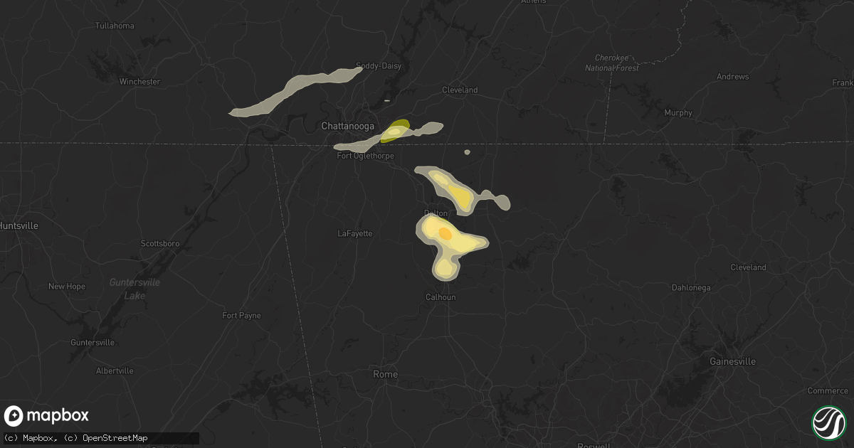
Hail Map in Dalton, GA on August 17, 2024
Get this storm
August 17 map
$229
one time, instant access
Download today. No call, no setup
Keep the $229
Bought the map and want the full workflow? Apply the entire $229 to a subscription within 7 days. None of it is wasted.
Every map, not just this one
This buys you this map. Subscription and you get every map we run, in the markets you choose from a few cities to whole states to nationwide. Plus real-time alerts the moment a storm fires.
Contact data
Name, contact info, occupancy, even credit band for addresses in the footprint. You go from where it hit to who to call.
Become the source they trust
Unlimited branding weather history reports on demand. You already have the documented answer ready for the property owner, and you are the one who showed up with it.
Property data and RoofTrace estimates
Pull up any address you have got, its value and the exact code rules for that jurisdiction, straight from One Click Code. Then RoofTrace estimates the squares, pitch, and roof value, priced the way you price.
Storm reports in Dalton, GA
Dalton, GA
| Date | Description |
|---|---|
| 08/17/20243:51 PM CDT | Report from mping: ping pong ball |
| 08/17/20243:49 PM CDT | Report from mping: quarter |
| 08/17/20243:44 PM CDT | Tree downed along wiggins road ne blocking both lanes. |
| 08/17/20243:30 PM CDT | Tree reported down in the road near the intersection of dawnville beaverdal rd and renfroe rd. Ne. |
| 08/17/20243:30 PM CDT | Tree reported down in the road near the int |
| 08/17/20243:28 PM CDT | Tree reported down across the road near the intersection of mcgaughey chapel rd and wilson rd. |
| 08/17/20243:25 PM CDT | Tree down across the roadway near the intersection of meers rd and durham st. |
All States Impacted by Hail Map on August 17, 2024
All Cities Impacted by Hail Map on August 17, 2024
- Sugar Grove, IL
- Aurora, IL
- Batavia, IL
- West Chicago, IL
- North Aurora, IL
- Geneva, IL
- Warrenville, IL
- Winfield, IL
- Carol Stream, IL
- Mooseheart, IL
- Wheaton, IL
- Addison, IL
- Glen Ellyn, IL
- Villa Park, IL
- Glendale Heights, IL
- Lombard, IL
- Elmhurst, IL
- Hillside, IL
- Berkeley, IL
- Naperville, IL
- Oak Brook, IL
- Lisle, IL
- Downers Grove, IL
- Westmont, IL
- Elkins, AR
- Picher, OK
- Tiff City, MO
- Miami, OK
- Centerton, AR
- Thayer, KS
- Galesburg, KS
- Fayetteville, AR
- Noel, MO
- Decatur, AR
- Erie, KS
- Buffalo, KS
- Benedict, KS
- Parsons, KS
- Cave Springs, AR
- Chanute, KS
- Wyandotte, OK
- Lowell, AR
- Bella Vista, AR
- Altoona, KS
- Treece, KS
- Anderson, MO
- Lincoln, AR
- Gravette, AR
- West Fork, AR
- Columbus, KS
- Seneca, MO
- Baxter Springs, KS
- Sulphur Springs, AR
- McCune, KS
- Saint Paul, KS
- Chetopa, KS
- Siloam Springs, AR
- Bartlett, KS
- Rogers, AR
- Prairie Grove, AR
- Commerce, OK
- Lanagan, MO
- Quapaw, OK
- Altamont, KS
- Gentry, AR
- South West City, MO
- Bentonville, AR
- Yates Center, KS
- Farmington, AR
- Dennis, KS
- Springdale, AR
- Goodman, MO
- Hiwasse, AR
- Oswego, KS
- Pineville, MO
- Winslow, AR
- Birch Tree, MO
- Winona, MO
- Ada, OK
- Muskogee, OK
- Vanceburg, KY
- De Mossville, KY
- Butler, KY
- Ord, NE
- Dunning, NE
- North Loup, NE
- Foster, KY
- Williamsburg, OH
- Mount Orab, OH
- Bethel, OH
- New Richmond, OH
- Moscow, OH
- Fayetteville, OH
- Scotia, NE
- Oakland, KY
- Bowling Green, KY
- Falmouth, KY
- Ellisville, MS
- Wolbach, NE
- Hillsboro, AL
- Felicity, OH
- Georgetown, OH
- Palmer, NE
- Brooksville, KY
- Frankfort, KY
- Hayneville, AL
- Aliceville, AL
- Augusta, KY
- Nashport, OH
- Hurricane, UT
- Butler, AL
- Fort Deposit, AL
- Minter, AL
- Fullerton, NE
- Belgrade, NE
- Winchester, OH
- Dover, KY
- Ripley, OH
- Russellville, OH
- Mount Sterling, KY
- Shelbyville, KY
- Waddy, KY
- Pine Apple, AL
- Jeffersonville, KY
- Frazeysburg, OH
- Belvidere, TN
- Mulberry, TN
- Winchester, TN
- Sherwood, TN
- Stevenson, AL
- Decatur, AL
- Toxey, AL
- Clarks, NE
- Cynthiana, KY
- Cadiz, OH
- West Union, OH
- Manchester, OH
- Aberdeen, OH
- Maysville, KY
- Kelso, TN
- Seaman, OH
- South Pittsburg, TN
- Meridian, MS
- Dillonvale, OH
- Adena, OH
- Seminary, MS
- Fayetteville, TN
- Germantown, KY
- Means, KY
- Paris, KY
- Bridgeport, AL
- Hartselle, AL
- Somerville, AL
- Peebles, OH
- Cecil, AL
- Mount Olivet, KY
- Carlisle, KY
- Northfield, OH
- Solon, OH
- Bedford, OH
- Shubuta, MS
- Loudonville, OH
- Perrysville, OH
- West Liberty, KY
- Sandy Hook, KY
- Clearfield, KY
- Morehead, KY
- Smithfield, OH
- Rayland, OH
- Mingo Junction, OH
- Lookout Mountain, GA
- Blue Creek, OH
- Lynx, OH
- Huntland, TN
- Elora, TN
- Flintville, TN
- Olive Hill, KY
- Stockton, NY
- Alton, UT
- Lynchburg, TN
- Shreve, OH
- Jeromesville, OH
- Wooster, OH
- Zanesville, OH
- Quitman, MS
- Stout, OH
- Wallingford, KY
- Chagrin Falls, OH
- Chattanooga, TN
- Flintstone, GA
- Rossville, GA
- Lookout Mountain, TN
- Moselle, MS
- Colliers, WV
- Wellsburg, WV
- Follansbee, WV
- Lawrenceburg, KY
- Mayslick, KY
- Tullahoma, TN
- Versailles, KY
- Salvisa, KY
- Sequatchie, TN
- Jasper, TN
- Flemingsburg, KY
- Cassadaga, NY
- Avella, PA
- Burgettstown, PA
- Tollesboro, KY
- Laceys Spring, AL
- Taylorsville, KY
- Mount Eden, KY
- Apison, TN
- Sweet Water, AL
- Estill Springs, TN
- Fosters, AL
- Falkville, AL
- Whitwell, TN
- Tracy City, TN
- Springboro, PA
- Bryant, AL
- Flat Rock, AL
- Sandyville, OH
- East Sparta, OH
- Ralph, AL
- Jackson, AL
- Grove Hill, AL
- Waynesburg, OH
- Magnolia, OH
- Frisco City, AL
- Lexington, KY
- Vossburg, MS
- Paulding, MS
- Kimbolton, OH
- Chillicothe, OH
- Ooltewah, TN
- Signal Mountain, TN
- Moundville, AL
- Union Grove, AL
- Nicholasville, KY
- Cambridge, OH
- Moorefield, KY
- Sharpsburg, KY
- Panguitch, UT
- Fort Oglethorpe, GA
- Cleveland, TN
- McDonald, TN
- Owingsville, KY
- Ray, OH
- Winchester, KY
- Richmond, KY
- Freeport, OH
- Midway, KY
- Wagarville, AL
- Charleston, TN
- Bloomingdale, OH
- Pine Hill, AL
- Tuscaloosa, AL
- Port Washington, OH
- Cottondale, AL
- Elkfork, KY
- Hollytree, AL
- Birchwood, TN
- Soddy Daisy, TN
- Trenton, GA
- Hillsboro, KY
- Thomaston, AL
- Arlington, AL
- Crandall, GA
- New Market, AL
- Springfield, KY
- Cisco, GA
- Chatsworth, GA
- Hollywood, AL
- Georgetown, TN
- Old Fort, TN
- Leroy, AL
- Ocoee, TN
- Benton, TN
- Uriah, AL
- Rising Fawn, GA
- Georgetown, KY
- Catherine, AL
- Wilmore, KY
- Hopedale, OH
- Hazel Green, AL
- Cusseta, AL
- Sale Creek, TN
- Ringgold, GA
- Cohutta, GA
- Tunnel Hill, GA
- Delano, TN
- Jewett, OH
- Alberta, AL
- Dalton, GA
- Wildwood, GA
- Seibert, CO
- Oil City, PA
- Heidelberg, MS
- Steubenville, OH
- Reliance, TN
- Titusville, PA
- Eva, AL
- Chickamauga, GA
- Lancaster, KY
- Macon, GA
- Camden, AL
- Higdon, AL
- Grove City, PA
- Volant, PA
- Mercer, PA
- Estillfork, AL
- Silver Creek, MS
- Vona, CO
- Stratton, CO
- La Fayette, GA
- Rocky Face, GA
- Weirton, WV
- Rock Spring, GA
- Mackville, KY
- Hendersonville, NC
- McCalla, AL
- Brookwood, AL
- Bessemer, AL
- Slippery Rock, PA
- Henagar, AL
- Wolf Creek, OR
- Menlo, GA
- Salt Lick, KY
- Ider, AL
- Cooperstown, PA
- Sonoita, AZ
- Opp, AL
- Olympia, KY
- Frenchburg, KY
- Flat Rock, NC
- Mount Vernon, AL
- Montevallo, AL
- Randolph, AL
- Portersville, PA
- Blountsville, AL
- Oneonta, AL
- McIntosh, AL
- Clay City, KY
- Stanton, KY
- Denniston, KY
- Wellington, KY
- Conover, NC
- Waco, KY
- Irvine, KY
- Perryville, KY
- Gravel Switch, KY
- Abbeville, GA
- Chunchula, AL
- Claremont, NC
- Wilsondale, WV
- Kermit, WV
- Crum, WV
- Lebanon, KY
- Loretto, KY
- Le Roy, NY
- Heber City, UT
- Kamas, UT
- Mountain Home, UT
- Tabiona, UT
- Roosevelt, UT
- Fruitland, UT
- Hanna, UT
- Evanston, WY
- Coalville, UT
- Woodruff, UT
- Tropic, UT
- Bryce, UT
- Escalante, UT
- Saluda, NC
- Hydetown, PA
- Sugar Valley, GA
- Calhoun, GA
- Resaca, GA
- Catawba, NC
- Centerville, PA
- Townville, PA
- Calera, AL
- Jemison, AL
- Brierfield, AL
- Breeden, WV
- Hickory, NC
- Summerville, GA
- Marion, AL
- Paint Lick, KY
- Ezel, KY
- Campton, KY
- Slade, KY
- Alabaster, AL
- Dingess, WV
- Salyersville, KY
- Hagerhill, KY
- Lucedale, MS
- Crab Orchard, KY
- Talking Rock, GA
- Ranger, GA
- Monticello, MS
- Jayess, MS
- Ruth, MS
- Chapmanville, WV
- Vail, AZ
- Chelsea, AL
- Alexandria, OH
- Johnstown, OH
- Pataskala, OH
- Eight Mile, AL
- Bogue Chitto, MS
- Clanton, AL
- Angie, LA
- Hazel Green, KY
- Saraland, AL
- Saint Louisville, OH
- Utica, OH
- Tryon, NC
- Columbus, NC
- Maplesville, AL
- Thorsby, AL
- Bethany, WV
- Brilliant, OH
- Parksville, KY
- Bradfordsville, KY
- Ellijay, GA
- Berea, KY
- Newton, NC
- Maiden, NC
- Logan, WV
- Coshocton, OH
- Harrodsburg, KY
- Plantersville, AL
- Bardwell, KY
- Sugar Grove, PA
- Warren, PA
- Russell, PA
- Granville, OH
- Robbinsville, NC
- Gadsden, AL
- Landrum, SC
- Colorado City, AZ
- Lenore, WV
- Lovely, KY
- Williamson, WV
- Campobello, SC
- Warsaw, OH
- Tellico Plains, TN
- Hickory, PA
- Arlington, KY
- Holden, WV
- Paducah, TX
- Stanford, KY
- Bethune, CO
- Clinton, KY
- Delbarton, WV
- Oakridge, OR
- Rockfield, KY
- Inman, SC
- Sylacauga, AL
- Childersburg, AL
- Ravenna, OH
- Pavilion, NY
- Talladega, AL
- Alpine, AL
- Jasper, GA
- Cokeville, WY
- Fort Bridger, WY
- Diamondville, WY
- Granger, WY
- Opal, WY
- McKinnon, WY
- Green River, WY
- Kemmerer, WY
- Mountain View, WY
- Lyman, WY
- Robertson, WY
- La Barge, WY
- Big Piney, WY
- Boulder, WY
- Pinedale, WY
- Bondurant, WY
- Daniel, WY
- Rock Springs, WY
- Cora, WY
- Farson, WY
- Superior, WY
- Reliance, WY
- Lander, WY
- Churchville, NY
- Chesnee, SC
- Ravenna, KY
- Prestonsburg, KY
- Akron, OH
- Brodhead, KY
- Isonville, KY
- Belfry, KY
- Mount Vernon, KY
- Mize, KY
- Burlington, CO
- Idanha, OR
- Bear Lake, PA
- Spartanburg, SC
- Canal Fulton, OH
- Clinton, OH
- Kent, OH
- Matewan, WV
- Wingo, KY
- Cannon Afb, NM
- Clovis, NM
- Uniontown, OH
- Marble Hill, GA
- Dawsonville, GA
- Tumacacori, AZ
- Liberty, MS
- Una, SC
- Tucson, AZ
- Youngsville, PA
- Man, WV
- Stollings, WV
- Yolyn, WV
- Lyburn, WV
- Switzer, WV
- Manchester, KY
- Twinsburg, OH
- Amherstdale, WV
- Jonesville, SC
- Pacolet, SC
- Canon, GA
- Roebuck, SC
- Arcadia, SC
- Trinity Center, CA
- Bowersville, GA
- Lavonia, GA
- Pauline, SC
- Russellville, KY
- Lewisburg, KY
- Grayson, LA
- Hartwell, GA
- Rousseau, KY
- Tallmadge, OH
- Cottonwood, CA
- Red Bluff, CA
- Riverton, WY
- Arapahoe, WY
- Fort Washakie, WY
- Hudson, WY
- Jeffrey City, WY
- Wamsutter, WY
- Bairoil, WY
- Crowheart, WY
- Kinnear, WY
- Dubois, WY
- Auburn, KY
- Wellford, SC
- Heflin, AL
- Ranburne, AL
- Big Creek, KY
- Union, SC
- Jackson, KY
- Buffalo, SC
- Bloomfield, KY
- Coxs Creek, KY
- Estacada, OR
- Saint George, UT
- Snyder, TX
- Cuyahoga Falls, OH
- Lakemore, OH
- Graham, AL
- Helton, KY
- Bledsoe, KY
- Burkesville, KY
- Picayune, MS
- Cave City, KY
- Atmore, AL
- Century, FL
- Dahlonega, GA
- Roark, KY
- Essie, KY
- Woodland, AL
- Redding, CA
- Anderson, CA
- Lakehead, CA
- Simpsonville, SC
- Sandy, OR
- Beattyville, KY
- Hammond, LA
- Tickfaw, LA
- Russell Springs, KY
- Nancy, KY
- Sells, AZ
- Jamestown, KY
- Moore, SC
- Bush, LA
- Bogalusa, LA
- Albany, KY
- Glasgow, KY
- Park City, KY
- Bowdon, GA
- Roopville, GA
- Woodruff, SC
- Fountain Inn, SC
- Ponchatoula, LA
- Science Hill, KY
- Brightwood, OR
- Welches, OR
- Rhododendron, OR
- Government Camp, OR
- Rawlins, WY
- Saratoga, WY
- Encampment, WY
- Savery, WY
- Baggs, WY
- Dixon, WY
- Wellsville, OH
- Pine Valley, UT
- Irving, NY
- Windsor, KY
- Monticello, KY
- Springfield, LA
- Scottsville, KY
- Byrdstown, TN
- Maysville, GA
- Hammondsville, OH
- Greer, SC
- Franklin, GA
- Daviston, AL
- Alexander City, AL
- Enoree, SC
- Whitmire, SC
- Anderson, SC
- Bronston, KY
- Somerset, KY
- Adolphus, KY
- Allons, TN
- Stanton, AL
- Clinton, SC
- Morganton, NC
- Monroe, TN
- Columbus, PA
- Lawley, AL
- Braddock, PA
- Pittsburgh, PA
- Hanna, WY
- Sinclair, WY
- Rock River, WY
- Laramie, WY
- Centennial, WY
- Bosler, WY
- Elk Mountain, WY
- Buford, WY
- Jelm, WY
- Rainbow City, AL
- Madras, OR
- Warm Springs, OR
- Middlesboro, KY
- Sharpsburg, GA
- Tyrone, GA
- Palmetto, GA
- Odenville, AL
- Moody, AL
- Port Allegany, PA
- Shinglehouse, PA
- Maupin, OR
- Detroit, OR
- Kinards, SC
- Petersburg, PA
- Hopkinsville, KY
- Elkton, KY
- Harrogate, TN
- Ewing, VA
- Abbeville, SC
- Bradley, SC
- Delta, AL
- Newnan, GA
- Calhoun Falls, SC
- Mount Carmel, SC
- Stevenson, WA
- Conneaut Lake, PA
- Linesville, PA
- Jamestown, TN
- Pall Mall, TN
- Tazewell, TN
- Williamson, GA
- Griffin, GA
- Huntingdon, PA
- Concord, GA
- Crofton, KY
- Dawson Springs, KY
- Olmstead, KY
- Fillmore, UT
- Sneedville, TN
- Dufur, OR
- Baton Rouge, LA
- Saint Gabriel, LA
- Sharon Grove, KY
- Alexandria, PA
- Alvaton, KY
- Shaniko, OR
- Adairville, KY
- Talent, OR
- Medford, OR
- Woodburn, KY
- The Dalles, OR
- Franklin, KY
- Trenton, KY
- Pembroke, KY
- Wilder, TN
- Thorn Hill, TN
- Kentwood, LA
- Mozelle, KY
- Carrollton, GA
- Newberry, SC
- Randle, WA
- Morton, WA
- Linwood, NY
- Caledonia, NY
- Piffard, NY
- Phoenix, OR
- Whitesburg, GA
- Allensville, KY
- Guthrie, KY
- White Salmon, WA
- Trout Lake, WA
- Warbranch, KY
- Stinnett, KY
- Hyden, KY
- Jena, LA
- Centerville, WA
- Wishram, WA
- Wasco, OR
- Portland, TN
- Oak Grove, KY
- Marshall, NC
- Leicester, NC
- Alexander, NC
- Peachtree City, GA
- Springfield, TN
- White House, TN
- Grass Valley, OR
- Kent, OR
- Moro, OR
- Arlington, OR
- Condon, OR
- Wendover, UT
- Bethpage, TN
- Gallatin, TN
- Baxter, KY
- Cross Plains, TN
- Allardt, TN
- Roosevelt, WA
- Rufus, OR
- Goldendale, WA
- Bickleton, WA
- Willcox, AZ
- Hendersonville, TN
- Cottontown, TN
- Robbins, TN
- Sunbright, TN
- Clarksville, TN
- Greenbrier, TN
- Goodlettsville, TN
- Joelton, TN
- Mount Hood Parkdale, OR
- Glens Fork, KY
- Westmoreland, TN
- Rio Rico, AZ
- Rogers, KY
- Lewistown, PA
- Vanleer, TN
- Huntsville, TN
- Enumclaw, WA
- Lebanon, TN
- Walhonding, OH
- Cunningham, TN
- Palmyra, TN
- Buckley, WA
- Watertown, TN
- Wellsville, NY
- Whitesville, NY
- Andover, NY
- Deer Lodge, TN
- Dugway, UT
- Oliver Springs, TN
- Harriman, TN
- Fairview, TN
- Bon Aqua, TN
- Oak Ridge, TN
- Dalton, NY
- Swain, NY
- Greeneville, TN
- Pendleton, OR
- Plymouth, WA
- Umatilla, OR
- Prosser, WA
- Mabton, WA
- Helix, OR
- Boardman, OR
- Stanfield, OR
- Irrigon, OR
- Kennewick, WA
- Hermiston, OR
- Heppner, OR
- Lexington, OR
- Ione, OR
- Pilot Rock, OR
- Echo, OR
- Parkers Lake, KY
- Dunnville, KY
- Harlan, KY
- Oneida, KY
- Richmond, OH
- Greeley, NE
- Fort Mcdowell, AZ
- Okaton, SD
- Murdo, SD
- Midland, SD
- Draper, SD
- Milesville, SD
- Vivian, SD
- Hayes, SD
- Fort Pierre, SD
- Presho, SD
- Ideal, SD
- Winner, SD
- Witten, SD
- Dallas, SD
- Tryon, NE
- Colome, SD
- Wood, SD
- Gregory, SD
- Burke, SD
- Herrick, SD
- Mills, NE
- Naper, NE
- Atkinson, NE
- Stuart, NE
- Emmet, NE
- Oneill, NE
- Newport, NE
- Chambers, NE
- Ewing, NE
- Inman, NE


