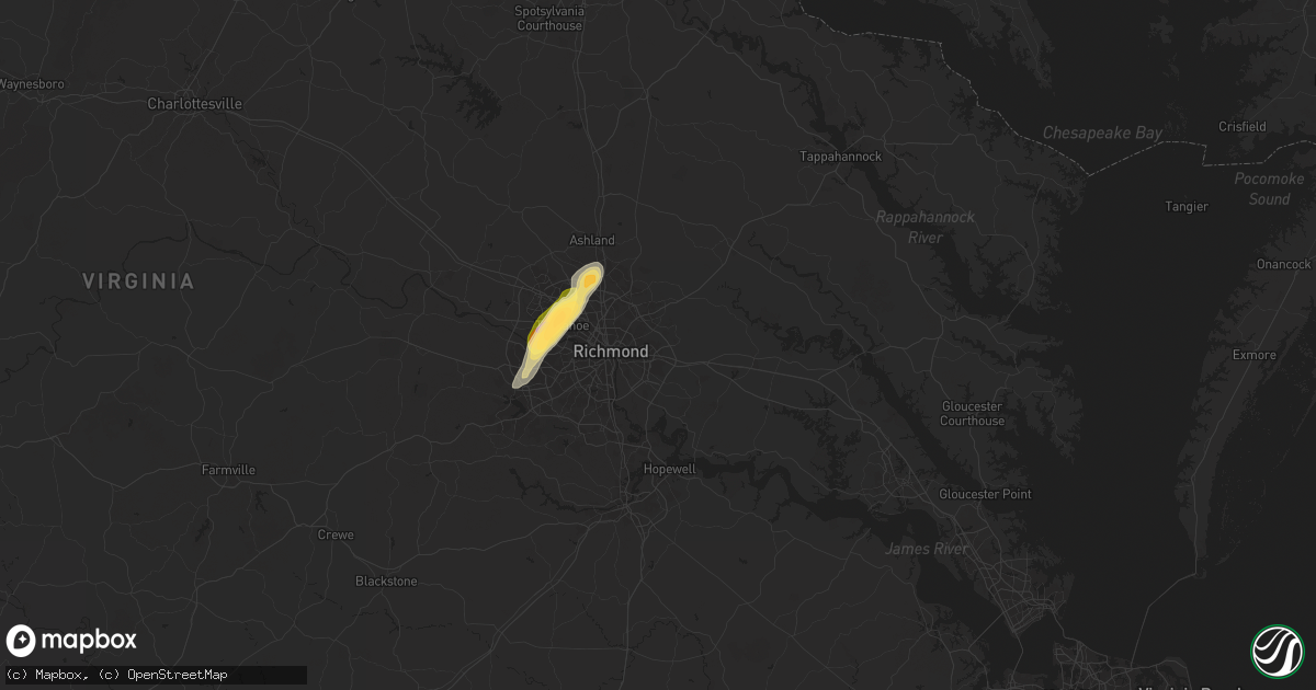
Hail Map in Henrico, VA on August 18, 2024
Get this storm
August 18 map
$229
one time, instant access
Download today. No call, no setup
Keep the $229
Bought the map and want the full workflow? Apply the entire $229 to a subscription within 7 days. None of it is wasted.
Every map, not just this one
This buys you this map. Subscription and you get every map we run, in the markets you choose from a few cities to whole states to nationwide. Plus real-time alerts the moment a storm fires.
Contact data
Name, contact info, occupancy, even credit band for addresses in the footprint. You go from where it hit to who to call.
Become the source they trust
Unlimited branding weather history reports on demand. You already have the documented answer ready for the property owner, and you are the one who showed up with it.
Property data and RoofTrace estimates
Pull up any address you have got, its value and the exact code rules for that jurisdiction, straight from One Click Code. Then RoofTrace estimates the squares, pitch, and roof value, priced the way you price.
Storm reports in Henrico, VA
Henrico, VA
| Date | Description |
|---|---|
| 08/18/20244:05 PM CDT | A local report indicates 1.00 inch wind near 3 W Laurel |
| 08/18/20243:55 PM CDT | I-64 and parham road. |
| 08/18/20243:53 PM CDT | A local report indicates 1.25 inch wind near 2 NE Tuckahoe |
| 08/18/20243:52 PM CDT | Trained spotter reported three solar pathway lights damaged from the hail with a fourth destroyed... Window screen damage to a home... And hail dents in vehicles includ |
| 08/18/20243:51 PM CDT | A local report indicates 1.50 inch wind near Tuckahoe |
| 08/18/20243:51 PM CDT | Public reports from social media show large hail estimated to be around two inches in diameter in the tuckahoe area. Time estimated from radar. |
| 08/18/20243:50 PM CDT | A tree fell onto an suv on parham road near aldi. No injuries were reported. |
| 08/18/20243:48 PM CDT | Minor structural damage to a home on gunby dr. |
| 08/18/20243:48 PM CDT | *** 1 fatal *** tree fell on a car and killed a man inside the car. Confirmed by broadcast media from henrico police and fire. |
| 08/18/20243:48 PM CDT | Tree downed on three chopt road at freeman high school. |
| 08/18/20243:45 PM CDT | Report from mping: half dollar |
| 08/18/20243:45 PM CDT | Tree down across desota drive. Multiple trees down and significant tree damage in the general area. |
All States Impacted by Hail Map on August 18, 2024
All Cities Impacted by Hail Map on August 18, 2024
- Chattanooga, TN
- Ooltewah, TN
- Ord, NE
- North Loup, NE
- Scotia, NE
- Greeley, NE
- Wolbach, NE
- Palmer, NE
- Belgrade, NE
- Fullerton, NE
- Ewing, NE
- Amelia, NE
- Burwell, NE
- Elgin, NE
- Petersburg, NE
- Ericson, NE
- Bartlett, NE
- Clearwater, NE
- Callaway, NE
- Spalding, NE
- Albion, NE
- Cedar Rapids, NE
- Primrose, NE
- Central City, NE
- Clarks, NE
- Kearney, NE
- Minden, NE
- Marquette, NE
- York, NE
- McCool Junction, NE
- Giltner, NE
- Holstein, NE
- Roseland, NE
- Bladen, NE
- Exeter, NE
- Fairmont, NE
- Ayr, NE
- Friend, NE
- Lawrence, NE
- Blue Hill, NE
- Superior, NE
- Guide Rock, NE
- Nelson, NE
- Belleville, KS
- Munden, KS
- Clyde, KS
- Clifton, KS
- Morganville, KS
- Clay Center, KS
- Gore, VA
- High View, WV
- Capon Bridge, WV
- Winchester, VA
- King George, VA
- Powder Springs, GA
- Marietta, GA
- Malvern, PA
- Paoli, PA
- Smyrna, GA
- Mableton, GA
- Harveyville, KS
- Burlingame, KS
- Auburn, KS
- Eskridge, KS
- Carbondale, KS
- Scranton, KS
- Osage City, KS
- Lyndon, KS
- Brodheadsville, PA
- Talladega, AL
- Cropwell, AL
- Wayne, PA
- Atlanta, GA
- Berwyn, PA
- Phoenixville, PA
- Pell City, AL
- Stroudsburg, PA
- King Of Prussia, PA
- Oaks, PA
- Collegeville, PA
- Norristown, PA
- Schwenksville, PA
- Harleysville, PA
- Skippack, PA
- Anniston, AL
- Alpine, AL
- Ellenwood, GA
- Decatur, GA
- Delaware Water Gap, PA
- East Stroudsburg, PA
- Vincent, AL
- Columbia, NJ
- Goodwater, AL
- Roanoke, AL
- Delta, UT
- Conley, GA
- Stockbridge, GA
- Wilsons, VA
- Benedict, NE
- Cragford, AL
- Wadley, AL
- Morrow, GA
- Jonesboro, GA
- Rex, GA
- Perkasie, PA
- Quakertown, PA
- Five Points, AL
- Millerville, AL
- Ashland, AL
- Pinson, AL
- Gaffney, SC
- Richmond, VA
- Midlothian, VA
- Morris, AL
- Heflin, AL
- Hector, AR
- Dover, AR
- Springfield, AR
- Remlap, AL
- Sylacauga, AL
- Berry, AL
- Northport, AL
- Covington, GA
- Gordo, AL
- Kimberly, AL
- Asbury, NJ
- Birmingham, AL
- Plumerville, AR
- El Paso, AR
- Russellville, AR
- Henrico, VA
- Greenbrier, AR
- Alexander City, AL
- Ranburne, AL
- Colonial Beach, VA
- Caret, VA
- Bowling Green, VA
- Hattieville, AR
- Lagrange, GA
- Lanett, AL
- Oxford, NC
- Mansfield, GA
- Daviston, AL
- Jacksons Gap, AL
- Dadeville, AL
- Glen Allen, VA
- Beebe, AR
- Tuscaloosa, AL
- Kellyton, AL
- Jerusalem, AR
- Duck Hill, MS
- Solgohachia, AR
- Hampton, NJ
- Glen Gardner, NJ
- Pittstown, NJ
- Clinton, NJ
- Conway, AR
- Elrod, AL
- Trussville, AL
- Ashland, VA
- Ward, AR
- West Point, GA
- Newnan, GA
- Whitesburg, GA
- Vilonia, AR
- Morrilton, AR
- Wooster, AR
- Damascus, AR
- Austin, AR
- Filer, ID
- Twin Falls, ID
- Brookwood, AL
- Waco, GA
- Buhl, AL
- Ralph, AL
- Catawba, SC
- Eatonton, GA
- Hustle, VA
- Port Royal, VA
- Winona, MS
- Carrollton, GA
- Cottondale, AL
- Lonoke, AR
- Carlisle, AR
- Cabot, AR
- Waverly, AL
- Camp Hill, AL
- Mount Bethel, PA
- Bangor, PA
- Sheridan, AR
- Eutaw, AL
- Brierfield, AL
- Centreville, AL
- Griffin, GA
- Boydton, VA
- Columbus, GA
- Fortson, GA
- Smiths Station, AL
- Phenix City, AL
- Show Low, AZ
- Lead, SD
- Hill City, SD
- Knoxville, AL
- Fosters, AL
- West Blocton, AL
- Milledgeville, GA
- Bracey, VA
- South Hill, VA
- Auburn, AL
- Hamilton, GA
- Lancaster, SC
- Randolph, AL
- Hazen, AR
- Bauxite, AR
- Cleveland, AR
- Enola, AR
- Mount Vernon, AR
- Cataula, GA
- Loretto, VA
- Jerome, ID
- Moundville, AL
- Midland, GA
- De Valls Bluff, AR
- Willow Spring, NC
- Center Ridge, AR
- Enid, OK
- White Hall, AR
- Lawley, AL
- Forest Park, GA
- Akron, AL
- Villa Rica, GA
- Winston, GA
- Douglasville, GA
- Shelton, WA
- Darby, MT
- Union Springs, AL
- Tuskegee, AL
- Medicine Lodge, KS
- Gibbonsville, ID
- Opelika, AL
- Mount Pleasant, NC
- Pine Bluff, AR
- Equality, AL
- Eclectic, AL
- Gold Hill, NC
- Fort Lawn, SC
- Gaithersburg, MD
- Atkins, AR
- Prattsville, AR
- Brent, AL
- Roe, AR
- Maplesville, AL
- Forsyth, GA
- Sawyerville, AL
- Weogufka, AL
- Carthage, AR
- Leola, AR
- Hazelton, ID
- Malvern, AR
- North Fork, ID
- Richfield, NC
- Jefferson, AR
- Marion, AL
- Hatchechubbee, AL
- Hurtsboro, AL
- Seale, AL
- Greensboro, AL
- Clarendon, AR
- Des Arc, AR
- Plantersville, AL
- Tallassee, AL
- Macon, GA
- Poyen, AR
- Pittsview, AL
- Bentonville, AR
- Harrison, GA
- Tennille, GA
- Watts, OK
- Centerton, AR
- Hiwasse, AR
- Gravette, AR
- Blackfoot, ID
- Lexington, NC
- Fort Valley, GA
- Roberta, GA
- Selma, AL
- New London, NC
- Germantown, MD
- Montgomery Village, MD
- Casscoe, AR
- Uniontown, AL
- Newbern, AL
- Shoup, ID
- Fairmont, OK
- McLeod, MT
- Holly Grove, AR
- Springdale, AR
- Fayetteville, AR
- Gallion, AL
- Wrightsville, GA
- Faunsdale, AL
- Pelsor, AR
- Albemarle, NC
- Star City, AR
- Biscoe, AR
- Thomasville, NC
- Rogers, AR
- Lowell, AR
- Gentry, AR
- Absarokee, MT
- Jackson, MT
- Donaldson, AR
- Cockeysville, MD
- Hindsville, AR
- Siloam Springs, AR
- Chinle, AZ
- Ganado, AZ
- Farmington, AR
- Prairie Grove, AR
- Yorktown, AR
- De Witt, AR
- Saint Charles, AR
- Tyler, AL
- Sardis, AL
- Marion Junction, AL
- Montello, NV
- Elkins, AR
- Wesley, AR
- Clinton, MT
- Philipsburg, MT
- West Fork, AR
- Winslow, AR
- Lincoln, AR
- Stevensville, MT
- Huntsville, AR
- Scranton, SC
- Bismarck, AR
- Crumrod, AR
- Pamplico, SC
- Witter, AR
- Montgomery, AL
- Dumas, AR
- Dry Branch, GA
- Wadley, GA
- Grouse Creek, UT
- Watson, AR
- Drummond, MT
- Arkadelphia, AR
- Lititz, PA
- Mount Joy, PA
- Landisville, PA
- Manheim, PA
- Columbia, PA
- Lancaster, PA
- Arlington, AL
- Thomaston, AL
- Combs, AR
- Alligator, MS
- Duncan, MS
- Rupert, ID
- Grady, AR
- Tillar, AR
- Pickens, AR
- Gould, AR
- Mellwood, AR
- Hagarville, AR
- Rockford, AL
- Magnolia, AL
- Pine Hill, AL
- Pike Road, AL
- Monticello, AR
- Mardela Springs, MD
- Pettigrew, AR
- Saint Paul, AR
- Sparkman, AR
- Windsor Mill, MD
- Parkville, MD
- Glen Arm, MD
- Towson, MD
- Tarrytown, GA
- Soperton, GA
- Choteau, MT
- Rosedale, MS
- Gunnison, MS
- Mountville, PA
- Nottingham, MD
- Glenwood, GA
- Rockledge, GA
- Lamar, AR
- Shelby, MS
- Thomasville, AL
- Elaine, AR
- Mound Bayou, MS
- Drew, MS
- Buhl, ID
- Clayton, AL
- Perry Hall, MD
- Midway, AL
- Baltimore, MD
- Merigold, MS
- Vienna, MD
- Wilmar, AR
- McGehee, AR
- Mount Judea, AR
- Gurdon, AR
- Beulah, MS
- Boyle, MS
- Cleveland, MS
- Fountain Hill, AR
- Greenbank, WA
- Augusta, MT
- Millersville, PA
- Washington Boro, PA
- East Petersburg, PA
- Hamburg, AR
- Coupeville, WA
- Rohwer, AR
- Benoit, MS
- Ozone, AR
- Roberts, ID
- Menan, ID
- Ruleville, MS
- Doddsville, MS
- Kingsville, MD
- Mount Vernon, GA
- Arkansas City, AR
- Lake Village, AR
- Greenville, MS
- Dermott, AR
- Missoula, MT
- Troy, AL
- Minter, AL
- Shaw, MS
- Leeds, AL
- Sterrett, AL
- Vandiver, AL
- Portland, AR
- Ramer, AL
- Grady, AL
- Brinkley, AR
- Moro, AR
- Conestoga, PA
- Deer, AR
- Rexburg, ID
- Clarksville, AR
- Indianola, MS
- Delaware, AR
- Knoxville, AR
- Scranton, AR
- New Blaine, AR
- London, AR
- Fairfield, MT
- Vidalia, GA
- Parkdale, AR
- Schlater, MS
- Eudora, AR
- Wilmot, AR
- Ailey, GA
- Sunflower, MS
- Pequea, PA
- Clarksdale, MS
- Minter City, MS
- Marvell, AR
- Johnsonville, SC
- Brundidge, AL
- Lake Providence, LA
- Oak Grove, LA
- Dardanelle, AR
- Greenwood, MS
- Lyons, GA
- Bellevue, ID
- Fairfield, ID
- Ketchum, ID
- Hailey, ID
- Sun Valley, ID
- Mackay, ID
- Philipp, MS
- Floweree, MT
- Great Falls, MT
- Ariton, AL
- Chidester, AR
- Geyser, MT
- Rosedale, MD
- Metter, GA
- Twin City, GA
- Whiteville, NC
- Clarkton, NC
- Jacksonville, GA
- Moorhead, MS
- Sidon, MS
- Carrollton, MS
- Itta Bena, MS
- Rover, AR
- Plainview, AR
- Ola, AR
- Rolling Fork, MS
- Mayersville, MS
- Bladenboro, NC
- Transylvania, LA
- North Little Rock, AR
- Scott, AR
- Jacksonville, AR
- Sherwood, AR
- Mountain Pine, AR
- Royal, AR
- Hot Springs National Park, AR
- Jessieville, AR
- Malad City, ID
- Paron, AR
- Evergreen, NC
- Carter, MT
- Dothan, AL
- Wickes, AR
- Stanton, AL
- Little Rock Air Force Base, AR
- Umpire, AR
- Grannis, AR
- Prattville, AL
- Billingsley, AL
- Autaugaville, AL
- Flora, MS
- Canton, MS
- Bentonia, MS
- Alexander, AR
- Arimo, ID
- Mccammon, ID
- Mount Ida, AR
- Story, AR
- Pelham, GA
- Cairo, GA
- Cottonwood, AL
- Ashford, AL
- Langley, AR
- Downey, ID
- Gillham, AR
- Bonnerdale, AR
- Amity, AR
- Pearcy, AR
- Glenwood, AR
- Fort Benning, GA
- Brady, MT
- Rocky Ford, CO
- Madison, MS
- De Queen, AR
- Highwood, MT
- Traskwood, AR
- Norman, AR
- Mabelvale, AR
- Redfield, AR
- Hensley, AR
- North Myrtle Beach, SC
- Calabash, NC
- Little River, SC
- Sunset Beach, NC
- Ocean Isle Beach, NC
- Shallotte, NC
- Arco, ID
- Carey, ID
- Moore, ID
- Atomic City, ID
- Montrose, AR
- Fort Benton, MT
- Dierks, AR
- Little Rock, AR
- Whigham, GA
- Ordway, CO
- Olar, SC
- Ledger, MT
- Geraldine, MT
- Cope, SC
- Branchville, SC
- Bamberg, SC
- Fordyce, AR
- Bearden, AR
- Ochlocknee, GA
- Meigs, GA
- Lumber City, GA
- Uvalda, GA
- Nashville, AR
- Sugar City, CO
- Loma, MT
- Murfreesboro, AR
- Benton, AR
- Delight, AR
- Savannah, GA
- Tybee Island, GA
- Newhope, AR
- Hermitage, AR
- Marianna, FL
- Grand Ridge, FL
- Slocomb, AL
- Prescott, AR
- Cascade, MT
- Simms, MT
- Fort Shaw, MT
- Vaughn, MT
- Sun River, MT
- Power, MT
- Magnolia, AR
- Crossett, AR
- Emerson, AR
- Coward, SC
- Thornton, AR
- Chester, MT
- Newton, AL
- Mount Gilead, NC
- Kershaw, SC
- Moncks Corner, SC
- Bonneau, SC
- Louin, MS
- Paulding, MS
- Bay Springs, MS
- Whitlash, MT
- Georgetown, SC
- Andrews, SC
- Heidelberg, MS
- Columbia, LA
- Monroe, LA
- West Monroe, LA
- Big Sandy, MT
- Andalusia, AL
- Florala, AL
- Blakely, GA
- Jakin, GA
- Brewton, AL
- Chester, AR
- Donalsonville, GA
- Colquitt, GA
- Proctor, OK
- Jersey, AR
- Kirby, AR
- Lonsdale, AR
- Grapevine, AR
- Sherrill, AR
- Altheimer, AR
- Stuttgart, AR
- Crocketts Bluff, AR
- Stilwell, OK
- Tahlequah, OK
- Natural Dam, AR
- Bunch, OK
- Brinson, GA
- Rudy, AR
- Mountainburg, AR
- Uniontown, AR
- Muldrow, OK
- Lucedale, MS
- Lavaca, AR
- Cedarville, AR
- Van Buren, AR
- Alma, AR
- Leakesville, MS
- Fort Smith, AR
- Sallisaw, OK
- Charleston, AR
- Ponce De Leon, FL
- Freeport, FL
- Roland, OK
- Wilmer, AL
- Greenwood, AR
- Barling, AR
- Doerun, GA
- Booneville, AR
- Vernon, FL
- Huntington, AR
- Mansfield, AR
- Hackett, AR
- Arkoma, OK
- Pocola, OK
- Spiro, OK
- Waldron, AR
- Hartford, AR
- Cameron, OK
- Santa Rosa Beach, FL
- Heavener, OK
- Howe, OK
- Poteau, OK
- Sims, AR
- Mena, AR
- Boles, AR
- Westville, OK
- Zortman, MT
- Kansas, OK
- Evansville, AR
- Canehill, AR
- Hays, MT
- Winnett, MT
- Summers, AR
- Malta, MT
- Dodson, MT


