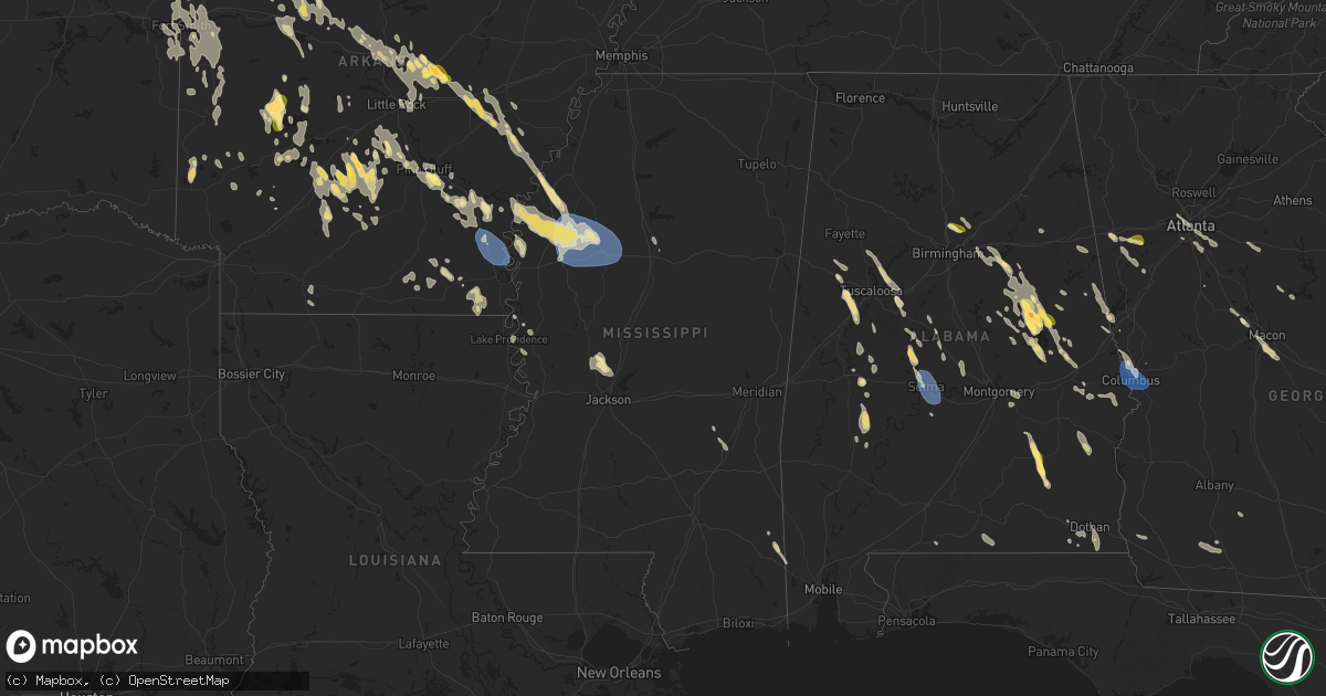
Hail Map in Mississippi on August 18, 2024
Get this storm
August 18 map
$229
one time, instant access
Download today. No call, no setup
Keep the $229
Bought the map and want the full workflow? Apply the entire $229 to a subscription within 7 days. None of it is wasted.
Every map, not just this one
This buys you this map. Subscription and you get every map we run, in the markets you choose from a few cities to whole states to nationwide. Plus real-time alerts the moment a storm fires.
Contact data
Name, contact info, occupancy, even credit band for addresses in the footprint. You go from where it hit to who to call.
Become the source they trust
Unlimited branding weather history reports on demand. You already have the documented answer ready for the property owner, and you are the one who showed up with it.
Property data and RoofTrace estimates
Pull up any address you have got, its value and the exact code rules for that jurisdiction, straight from One Click Code. Then RoofTrace estimates the squares, pitch, and roof value, priced the way you price.
Storm reports in Mississippi
Mississippi
| Date | Description |
|---|---|
| 08/18/20246:58 PM CDT | Local law enforcement reported a powerline down near w main st east of duncan ms along with a few downed trees. |
| 08/18/20241:41 AM CDT | Measured by personal weather station. Tree damage also reported in the area. |
| 08/17/202411:37 PM CDT | Utility pole snapped near cr 14 at cr 31. |
| 08/17/202411:37 PM CDT | Large tree downed on ms highway 528 near oak bowery. |
| 08/17/202411:29 PM CDT | Trees and powerlines downed at the intersection of cr 29 and cr 293. |
| 08/17/202410:07 PM CDT | Tree downed around the 220 block of morgantown road. Time estimated based on radar. |
| 08/17/20249:45 PM CDT | Corrects previous tstm wnd dmg report from 2 ne russum. Trees |
| 08/17/20249:45 PM CDT | Corrects previous tstm wnd dmg report from 2 ne russum. Trees down along old gordon annex. |
| 08/17/20249:40 PM CDT | Trees down along hwy 18 near the claiborne/copiah county line. |
| 08/17/20249:33 PM CDT | Tree downed and laying across the road near the 3200 block of marion dunbar street. Time estimated based on radar. |
| 08/17/20249:26 PM CDT | Trees downed between the intersection of cedar hill rd and gus green rd. |
| 08/17/20249:20 PM CDT | Downed trees between the intersection of robinson springs rd and coker dr. |
| 08/17/20249:20 PM CDT | Down trees between the intersection of robinson springs road and deer haven drive. |
| 08/17/20249:19 PM CDT | Trees and powerlines downed on old port gibson road and bill strong road. Time estimated based on radar. |
| 08/17/20249:10 PM CDT | Trees downed onto powerline along redbone rd. |
| 08/17/20249:10 PM CDT | A tree fell on a house along nailor rd near poole rd. |
| 08/17/20249:05 PM CDT | Tree down along ms highway 27 between gibson rd and warriors trail. |
| 08/17/20249:05 PM CDT | Tree downed on halls ferry rd near greerbriar. |
| 08/17/20249:00 PM CDT | Tree and power lines downed along culkin rd. |
| 08/17/20248:55 PM CDT | Multiple trees downed... Blocking oak ridge rd. |
| 08/17/20248:45 PM CDT | Trees down along old gordon annex. |
| 08/17/20248:45 PM CDT | Widespread downed trees along the eagle lake community. |
| 08/17/20248:45 PM CDT | Tree down across ms highway 465 near eagle lake. Report via social media. |
| 08/17/20248:30 PM CDT | Downed powerlines on coker road. Time estimated based on radar. |
| 08/17/20248:23 PM CDT | Trees down on moon lake rd. Time estimated based on radar. |
| 08/17/20248:15 PM CDT | Majority of anguilla without power due to downed powerlines. |
| 08/17/20248:05 PM CDT | Tree downed on church st. Time estimated based on radar. |
| 08/17/20247:58 PM CDT | Law enforcement reported multiple trees and powerlines down across sunflower county. |
| 08/17/20247:57 PM CDT | Tree downed on edna st. Time estimated based on radar. |
| 08/17/20247:51 PM CDT | Recorded by private weather station near schlater. |
| 08/17/20247:45 PM CDT | Two trees fell on vehicles and one tree fell on a house in moorhead. |
| 08/17/20247:40 PM CDT | Tree downed across cypress ln. |
| 08/17/20247:40 PM CDT | Tree downed across broadway st. |
| 08/17/20247:40 PM CDT | City of greenville reports several downed trees and powerlines across the city... Including along hwy 1... Witchtree... Tampa at us 82... Omega... And goodrich at willi |
| 08/17/20247:37 PM CDT | City of greenville reports downed trees and possible building damage at the glh airport. |
| 08/17/20247:00 PM CDT | A tree was snapped and a chicken coop was damaged in rosedale. |
All States Impacted by Hail Map on August 18, 2024
Cities Impacted by Hail Map on August 18, 2024
- Chattanooga, TN
- Ooltewah, TN
- Ord, NE
- North Loup, NE
- Scotia, NE
- Greeley, NE
- Wolbach, NE
- Palmer, NE
- Belgrade, NE
- Fullerton, NE
- Ewing, NE
- Amelia, NE
- Burwell, NE
- Elgin, NE
- Petersburg, NE
- Ericson, NE
- Bartlett, NE
- Clearwater, NE
- Callaway, NE
- Spalding, NE
- Albion, NE
- Cedar Rapids, NE
- Primrose, NE
- Central City, NE
- Clarks, NE
- Kearney, NE
- Minden, NE
- Marquette, NE
- York, NE
- McCool Junction, NE
- Giltner, NE
- Holstein, NE
- Roseland, NE
- Bladen, NE
- Exeter, NE
- Fairmont, NE
- Ayr, NE
- Friend, NE
- Lawrence, NE
- Blue Hill, NE
- Superior, NE
- Guide Rock, NE
- Nelson, NE
- Belleville, KS
- Munden, KS
- Clyde, KS
- Clifton, KS
- Morganville, KS
- Clay Center, KS
- Gore, VA
- High View, WV
- Capon Bridge, WV
- Winchester, VA
- King George, VA
- Powder Springs, GA
- Marietta, GA
- Malvern, PA
- Paoli, PA
- Smyrna, GA
- Mableton, GA
- Harveyville, KS
- Burlingame, KS
- Auburn, KS
- Eskridge, KS
- Carbondale, KS
- Scranton, KS
- Osage City, KS
- Lyndon, KS
- Brodheadsville, PA
- Talladega, AL
- Cropwell, AL
- Wayne, PA
- Atlanta, GA
- Berwyn, PA
- Phoenixville, PA
- Pell City, AL
- Stroudsburg, PA
- King Of Prussia, PA
- Oaks, PA
- Collegeville, PA
- Norristown, PA
- Schwenksville, PA
- Harleysville, PA
- Skippack, PA
- Anniston, AL
- Alpine, AL
- Ellenwood, GA
- Decatur, GA
- Delaware Water Gap, PA
- East Stroudsburg, PA
- Vincent, AL
- Columbia, NJ
- Goodwater, AL
- Roanoke, AL
- Delta, UT
- Conley, GA
- Stockbridge, GA
- Wilsons, VA
- Benedict, NE
- Cragford, AL
- Wadley, AL
- Morrow, GA
- Jonesboro, GA
- Rex, GA
- Perkasie, PA
- Quakertown, PA
- Five Points, AL
- Millerville, AL
- Ashland, AL
- Pinson, AL
- Gaffney, SC
- Richmond, VA
- Midlothian, VA
- Morris, AL
- Heflin, AL
- Hector, AR
- Dover, AR
- Springfield, AR
- Remlap, AL
- Sylacauga, AL
- Berry, AL
- Northport, AL
- Covington, GA
- Gordo, AL
- Kimberly, AL
- Asbury, NJ
- Birmingham, AL
- Plumerville, AR
- El Paso, AR
- Russellville, AR
- Henrico, VA
- Greenbrier, AR
- Alexander City, AL
- Ranburne, AL
- Colonial Beach, VA
- Caret, VA
- Bowling Green, VA
- Hattieville, AR
- Lagrange, GA
- Lanett, AL
- Oxford, NC
- Mansfield, GA
- Daviston, AL
- Jacksons Gap, AL
- Dadeville, AL
- Glen Allen, VA
- Beebe, AR
- Tuscaloosa, AL
- Kellyton, AL
- Jerusalem, AR
- Duck Hill, MS
- Solgohachia, AR
- Hampton, NJ
- Glen Gardner, NJ
- Pittstown, NJ
- Clinton, NJ
- Conway, AR
- Elrod, AL
- Trussville, AL
- Ashland, VA
- Ward, AR
- West Point, GA
- Newnan, GA
- Whitesburg, GA
- Vilonia, AR
- Morrilton, AR
- Wooster, AR
- Damascus, AR
- Austin, AR
- Filer, ID
- Twin Falls, ID
- Brookwood, AL
- Waco, GA
- Buhl, AL
- Ralph, AL
- Catawba, SC
- Eatonton, GA
- Hustle, VA
- Port Royal, VA
- Winona, MS
- Carrollton, GA
- Cottondale, AL
- Lonoke, AR
- Carlisle, AR
- Cabot, AR
- Waverly, AL
- Camp Hill, AL
- Mount Bethel, PA
- Bangor, PA
- Sheridan, AR
- Eutaw, AL
- Brierfield, AL
- Centreville, AL
- Griffin, GA
- Boydton, VA
- Columbus, GA
- Fortson, GA
- Smiths Station, AL
- Phenix City, AL
- Show Low, AZ
- Lead, SD
- Hill City, SD
- Knoxville, AL
- Fosters, AL
- West Blocton, AL
- Milledgeville, GA
- Bracey, VA
- South Hill, VA
- Auburn, AL
- Hamilton, GA
- Lancaster, SC
- Randolph, AL
- Hazen, AR
- Bauxite, AR
- Cleveland, AR
- Enola, AR
- Mount Vernon, AR
- Cataula, GA
- Loretto, VA
- Jerome, ID
- Moundville, AL
- Midland, GA
- De Valls Bluff, AR
- Willow Spring, NC
- Center Ridge, AR
- Enid, OK
- White Hall, AR
- Lawley, AL
- Forest Park, GA
- Akron, AL
- Villa Rica, GA
- Winston, GA
- Douglasville, GA
- Shelton, WA
- Darby, MT
- Union Springs, AL
- Tuskegee, AL
- Medicine Lodge, KS
- Gibbonsville, ID
- Opelika, AL
- Mount Pleasant, NC
- Pine Bluff, AR
- Equality, AL
- Eclectic, AL
- Gold Hill, NC
- Fort Lawn, SC
- Gaithersburg, MD
- Atkins, AR
- Prattsville, AR
- Brent, AL
- Roe, AR
- Maplesville, AL
- Forsyth, GA
- Sawyerville, AL
- Weogufka, AL
- Carthage, AR
- Leola, AR
- Hazelton, ID
- Malvern, AR
- North Fork, ID
- Richfield, NC
- Jefferson, AR
- Marion, AL
- Hatchechubbee, AL
- Hurtsboro, AL
- Seale, AL
- Greensboro, AL
- Clarendon, AR
- Des Arc, AR
- Plantersville, AL
- Tallassee, AL
- Macon, GA
- Poyen, AR
- Pittsview, AL
- Bentonville, AR
- Harrison, GA
- Tennille, GA
- Watts, OK
- Centerton, AR
- Hiwasse, AR
- Gravette, AR
- Blackfoot, ID
- Lexington, NC
- Fort Valley, GA
- Roberta, GA
- Selma, AL
- New London, NC
- Germantown, MD
- Montgomery Village, MD
- Casscoe, AR
- Uniontown, AL
- Newbern, AL
- Shoup, ID
- Fairmont, OK
- McLeod, MT
- Holly Grove, AR
- Springdale, AR
- Fayetteville, AR
- Gallion, AL
- Wrightsville, GA
- Faunsdale, AL
- Pelsor, AR
- Albemarle, NC
- Star City, AR
- Biscoe, AR
- Thomasville, NC
- Rogers, AR
- Lowell, AR
- Gentry, AR
- Absarokee, MT
- Jackson, MT
- Donaldson, AR
- Cockeysville, MD
- Hindsville, AR
- Siloam Springs, AR
- Chinle, AZ
- Ganado, AZ
- Farmington, AR
- Prairie Grove, AR
- Yorktown, AR
- De Witt, AR
- Saint Charles, AR
- Tyler, AL
- Sardis, AL
- Marion Junction, AL
- Montello, NV
- Elkins, AR
- Wesley, AR
- Clinton, MT
- Philipsburg, MT
- West Fork, AR
- Winslow, AR
- Lincoln, AR
- Stevensville, MT
- Huntsville, AR
- Scranton, SC
- Bismarck, AR
- Crumrod, AR
- Pamplico, SC
- Witter, AR
- Montgomery, AL
- Dumas, AR
- Dry Branch, GA
- Wadley, GA
- Grouse Creek, UT
- Watson, AR
- Drummond, MT
- Arkadelphia, AR
- Lititz, PA
- Mount Joy, PA
- Landisville, PA
- Manheim, PA
- Columbia, PA
- Lancaster, PA
- Arlington, AL
- Thomaston, AL
- Combs, AR
- Alligator, MS
- Duncan, MS
- Rupert, ID
- Grady, AR
- Tillar, AR
- Pickens, AR
- Gould, AR
- Mellwood, AR
- Hagarville, AR
- Rockford, AL
- Magnolia, AL
- Pine Hill, AL
- Pike Road, AL
- Monticello, AR
- Mardela Springs, MD
- Pettigrew, AR
- Saint Paul, AR
- Sparkman, AR
- Windsor Mill, MD
- Parkville, MD
- Glen Arm, MD
- Towson, MD
- Tarrytown, GA
- Soperton, GA
- Choteau, MT
- Rosedale, MS
- Gunnison, MS
- Mountville, PA
- Nottingham, MD
- Glenwood, GA
- Rockledge, GA
- Lamar, AR
- Shelby, MS
- Thomasville, AL
- Elaine, AR
- Mound Bayou, MS
- Drew, MS
- Buhl, ID
- Clayton, AL
- Perry Hall, MD
- Midway, AL
- Baltimore, MD
- Merigold, MS
- Vienna, MD
- Wilmar, AR
- McGehee, AR
- Mount Judea, AR
- Gurdon, AR
- Beulah, MS
- Boyle, MS
- Cleveland, MS
- Fountain Hill, AR
- Greenbank, WA
- Augusta, MT
- Millersville, PA
- Washington Boro, PA
- East Petersburg, PA
- Hamburg, AR
- Coupeville, WA
- Rohwer, AR
- Benoit, MS
- Ozone, AR
- Roberts, ID
- Menan, ID
- Ruleville, MS
- Doddsville, MS
- Kingsville, MD
- Mount Vernon, GA
- Arkansas City, AR
- Lake Village, AR
- Greenville, MS
- Dermott, AR
- Missoula, MT
- Troy, AL
- Minter, AL
- Shaw, MS
- Leeds, AL
- Sterrett, AL
- Vandiver, AL
- Portland, AR
- Ramer, AL
- Grady, AL
- Brinkley, AR
- Moro, AR
- Conestoga, PA
- Deer, AR
- Rexburg, ID
- Clarksville, AR
- Indianola, MS
- Delaware, AR
- Knoxville, AR
- Scranton, AR
- New Blaine, AR
- London, AR
- Fairfield, MT
- Vidalia, GA
- Parkdale, AR
- Schlater, MS
- Eudora, AR
- Wilmot, AR
- Ailey, GA
- Sunflower, MS
- Pequea, PA
- Clarksdale, MS
- Minter City, MS
- Marvell, AR
- Johnsonville, SC
- Brundidge, AL
- Lake Providence, LA
- Oak Grove, LA
- Dardanelle, AR
- Greenwood, MS
- Lyons, GA
- Bellevue, ID
- Fairfield, ID
- Ketchum, ID
- Hailey, ID
- Sun Valley, ID
- Mackay, ID
- Philipp, MS
- Floweree, MT
- Great Falls, MT
- Ariton, AL
- Chidester, AR
- Geyser, MT
- Rosedale, MD
- Metter, GA
- Twin City, GA
- Whiteville, NC
- Clarkton, NC
- Jacksonville, GA
- Moorhead, MS
- Sidon, MS
- Carrollton, MS
- Itta Bena, MS
- Rover, AR
- Plainview, AR
- Ola, AR
- Rolling Fork, MS
- Mayersville, MS
- Bladenboro, NC
- Transylvania, LA
- North Little Rock, AR
- Scott, AR
- Jacksonville, AR
- Sherwood, AR
- Mountain Pine, AR
- Royal, AR
- Hot Springs National Park, AR
- Jessieville, AR
- Malad City, ID
- Paron, AR
- Evergreen, NC
- Carter, MT
- Dothan, AL
- Wickes, AR
- Stanton, AL
- Little Rock Air Force Base, AR
- Umpire, AR
- Grannis, AR
- Prattville, AL
- Billingsley, AL
- Autaugaville, AL
- Flora, MS
- Canton, MS
- Bentonia, MS
- Alexander, AR
- Arimo, ID
- Mccammon, ID
- Mount Ida, AR
- Story, AR
- Pelham, GA
- Cairo, GA
- Cottonwood, AL
- Ashford, AL
- Langley, AR
- Downey, ID
- Gillham, AR
- Bonnerdale, AR
- Amity, AR
- Pearcy, AR
- Glenwood, AR
- Fort Benning, GA
- Brady, MT
- Rocky Ford, CO
- Madison, MS
- De Queen, AR
- Highwood, MT
- Traskwood, AR
- Norman, AR
- Mabelvale, AR
- Redfield, AR
- Hensley, AR
- North Myrtle Beach, SC
- Calabash, NC
- Little River, SC
- Sunset Beach, NC
- Ocean Isle Beach, NC
- Shallotte, NC
- Arco, ID
- Carey, ID
- Moore, ID
- Atomic City, ID
- Montrose, AR
- Fort Benton, MT
- Dierks, AR
- Little Rock, AR
- Whigham, GA
- Ordway, CO
- Olar, SC
- Ledger, MT
- Geraldine, MT
- Cope, SC
- Branchville, SC
- Bamberg, SC
- Fordyce, AR
- Bearden, AR
- Ochlocknee, GA
- Meigs, GA
- Lumber City, GA
- Uvalda, GA
- Nashville, AR
- Sugar City, CO
- Loma, MT
- Murfreesboro, AR
- Benton, AR
- Delight, AR
- Savannah, GA
- Tybee Island, GA
- Newhope, AR
- Hermitage, AR
- Marianna, FL
- Grand Ridge, FL
- Slocomb, AL
- Prescott, AR
- Cascade, MT
- Simms, MT
- Fort Shaw, MT
- Vaughn, MT
- Sun River, MT
- Power, MT
- Magnolia, AR
- Crossett, AR
- Emerson, AR
- Coward, SC
- Thornton, AR
- Chester, MT
- Newton, AL
- Mount Gilead, NC
- Kershaw, SC
- Moncks Corner, SC
- Bonneau, SC
- Louin, MS
- Paulding, MS
- Bay Springs, MS
- Whitlash, MT
- Georgetown, SC
- Andrews, SC
- Heidelberg, MS
- Columbia, LA
- Monroe, LA
- West Monroe, LA
- Big Sandy, MT
- Andalusia, AL
- Florala, AL
- Blakely, GA
- Jakin, GA
- Brewton, AL
- Chester, AR
- Donalsonville, GA
- Colquitt, GA
- Proctor, OK
- Jersey, AR
- Kirby, AR
- Lonsdale, AR
- Grapevine, AR
- Sherrill, AR
- Altheimer, AR
- Stuttgart, AR
- Crocketts Bluff, AR
- Stilwell, OK
- Tahlequah, OK
- Natural Dam, AR
- Bunch, OK
- Brinson, GA
- Rudy, AR
- Mountainburg, AR
- Uniontown, AR
- Muldrow, OK
- Lucedale, MS
- Lavaca, AR
- Cedarville, AR
- Van Buren, AR
- Alma, AR
- Leakesville, MS
- Fort Smith, AR
- Sallisaw, OK
- Charleston, AR
- Ponce De Leon, FL
- Freeport, FL
- Roland, OK
- Wilmer, AL
- Greenwood, AR
- Barling, AR
- Doerun, GA
- Booneville, AR
- Vernon, FL
- Huntington, AR
- Mansfield, AR
- Hackett, AR
- Arkoma, OK
- Pocola, OK
- Spiro, OK
- Waldron, AR
- Hartford, AR
- Cameron, OK
- Santa Rosa Beach, FL
- Heavener, OK
- Howe, OK
- Poteau, OK
- Sims, AR
- Mena, AR
- Boles, AR
- Westville, OK
- Zortman, MT
- Kansas, OK
- Evansville, AR
- Canehill, AR
- Hays, MT
- Winnett, MT
- Summers, AR
- Malta, MT
- Dodson, MT


