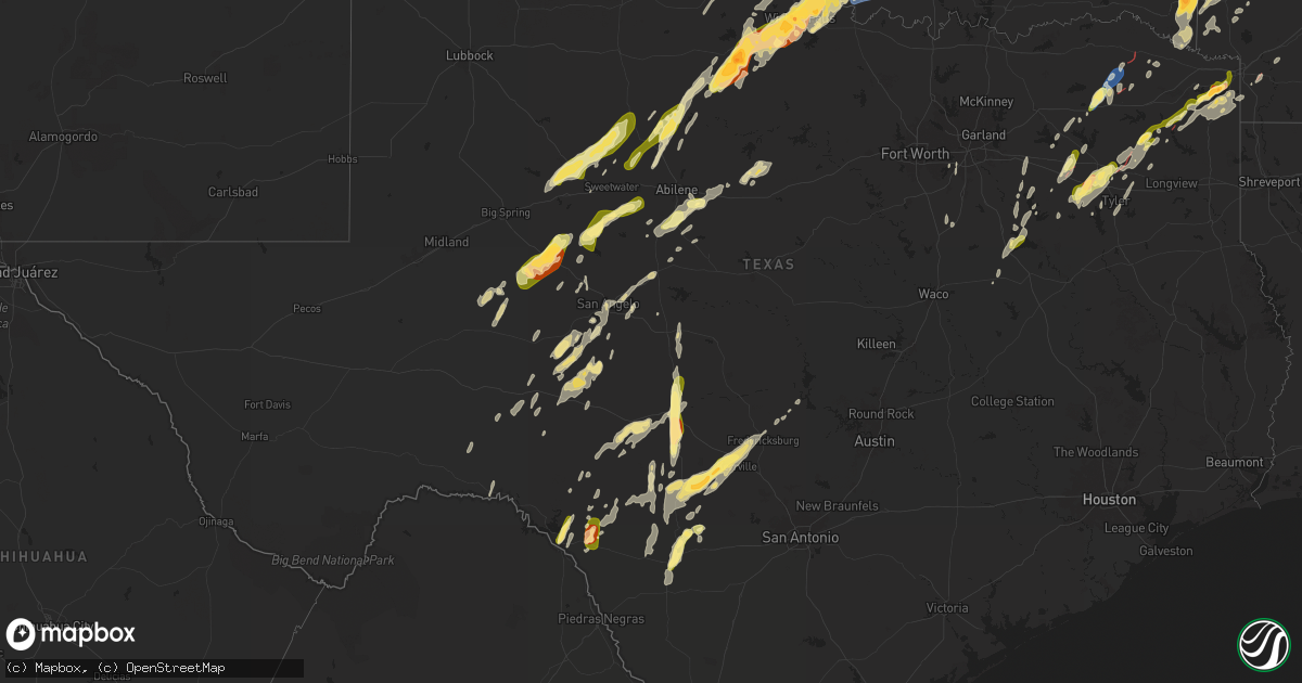
Hail Map in Texas on April 4, 2025
Get this storm
April 4 map
$229
one time, instant access
Download today. No call, no setup
Keep the $229
Bought the map and want the full workflow? Apply the entire $229 to a subscription within 7 days. None of it is wasted.
Every map, not just this one
This buys you this map. Subscription and you get every map we run, in the markets you choose from a few cities to whole states to nationwide. Plus real-time alerts the moment a storm fires.
Contact data
Name, contact info, occupancy, even credit band for addresses in the footprint. You go from where it hit to who to call.
Become the source they trust
Unlimited branding weather history reports on demand. You already have the documented answer ready for the property owner, and you are the one who showed up with it.
Property data and RoofTrace estimates
Pull up any address you have got, its value and the exact code rules for that jurisdiction, straight from One Click Code. Then RoofTrace estimates the squares, pitch, and roof value, priced the way you price.
Storm reports in Texas
Texas
| Date | Description |
|---|---|
| 04/04/20256:32 PM CDT | Ktbs-tv viewer reports golf ball size hail just east of maud community near wright patman lake. |
| 04/04/20255:34 PM CDT | Trees snapped... Overturned cars... And additional damage near the lakeview baptist assembly in lone star. |
| 04/04/20255:18 PM CDT | A local report indicates 1.00 inch wind near 3 N Bettie |
| 04/04/20255:05 PM CDT | Structural damage at union hill elementary. Possible tornado. |
| 04/04/20255:05 PM CDT | Multiple trees down on fm road 2088... West of us highway 271... Between the union hill and bettie communities. Also... Some structure damage from trees. |
| 04/04/20255:03 PM CDT | Carport lifted and damaged east end of barber rd in the bettie community. |
| 04/04/20255:00 PM CDT | Damage to bridge road surface on fm road 852 over lake gilmer. |
| 04/04/20254:55 PM CDT | Photo of destroyed residence in the kelsey community along state highway 154. |
| 04/04/20254:50 PM CDT | Horse loafing shed roof and walls damage and trees down on kelsey creek rd and cox trail... Just south of state hwy 154 in the kelsey community west of gilmer. |
| 04/04/20254:40 PM CDT | Pictures of damage at a manufacturing plant... Coincident with a tornadic debris signature. Time estimated by radar. |
| 04/04/20254:22 PM CDT | Damage reported at intersection of cr 1345 and cr 1360. |
| 04/04/20254:11 PM CDT | Dime to quarter size hail reported by amateur radio operator. |
| 04/04/20254:00 PM CDT | Report of confirmed tornado on ground near the talco community. |
| 04/04/20253:47 PM CDT | Report of a house destroyed on farm to market rd 909 from local sheriff. |
| 04/04/20253:28 PM CDT | Multiple trees down near fm 1255 and fm 773. |
| 04/04/20253:25 PM CDT | Reports of a tree on a house at fm 1255 and sh 110. Also a roof blown off of a house nearby. |
| 04/04/20253:22 PM CDT | Report of confirmed tornado and damage in rosalie community just east of bogata. |
| 04/04/20252:40 PM CDT | Report of down powerlines just east of eureka. |
| 04/04/20252:01 AM CDT | Report from mping: ping pong ball |
| 04/04/20251:50 AM CDT | Location and time are estimated. |
| 04/04/20251:48 AM CDT | A local report indicates 1.50 inch wind near 1 SW Wichita Falls |
| 04/04/20251:48 AM CDT | Report from mping: quarter |
| 04/04/20251:47 AM CDT | Report from mping: quarter |
| 04/04/20251:46 AM CDT | A local report indicates 1.00 inch wind near 2 N Lakeside City |
| 04/04/20251:45 AM CDT | Report from mping: golf ball |
| 04/04/20251:44 AM CDT | Report from mping: ping pong ball |
| 04/04/20251:43 AM CDT | Spotter network report. |
| 04/04/20251:43 AM CDT | A local report indicates 1.00 inch wind near 3 S Lakeside City |
| 04/04/20251:42 AM CDT | A local report indicates 1.00 inch wind near 3 NW Lakeside City |
| 04/04/20251:42 AM CDT | Report from mping: half dollar |
| 04/04/20251:38 AM CDT | Lots of nickel-size hail with some quarter-size. |
| 04/04/20251:38 AM CDT | A local report indicates 1.00 inch wind near 4 SSW Lakeside City |
| 04/04/20251:10 AM CDT | A local report indicates 1.00 inch wind near 4 S San Angelo |
| 04/04/202512:30 AM CDT | Report from mping half dollar. |
| 04/04/202512:05 AM CDT | A local report indicates 1.75 inch wind near 1 E Stamford |
| 04/03/202511:48 PM CDT | Report from mping: half dollar |
| 04/03/202511:45 PM CDT | Reported hail damage to cars and broken tree limbs. |
| 04/03/202511:45 PM CDT | A local report indicates 1.25 inch wind near Rotan |
| 04/03/202511:42 PM CDT | Hail anywhere from marble to quarter size. Also... Numerous dents on the hood of vehicle. Time estimated via radar. |
| 04/03/202511:34 PM CDT | The sterling county sheriff office reported golf ball size hail in sterling city. |
| 04/03/202511:01 PM CDT | Quarter to half dollar sized hail. |
All States Impacted by Hail Map on April 4, 2025
Cities Impacted by Hail Map on April 4, 2025
- Muskogee, OK
- Fort Gibson, OK
- Wagoner, OK
- Porter, OK
- Ozark, AR
- Mulberry, AR
- Pettigrew, AR
- Vernon, TX
- Parma, MO
- New Madrid, MO
- Matthews, MO
- Catron, MO
- Alton, MO
- Fremont, MO
- Essex, MO
- Van Buren, MO
- Springdale, AR
- Blair, OK
- Altus, OK
- Lone Wolf, OK
- Mangum, OK
- Oark, AR
- Powell, TX
- Mexia, TX
- Rockholds, KY
- Corbin, KY
- Kemp, TX
- Chatfield, TX
- Sulphur Springs, TX
- Williamsburg, KY
- Wortham, TX
- Richland, TX
- Woodbine, KY
- Greenville, TX
- Campbell, TX
- Cumby, TX
- Brashear, TX
- Dike, TX
- Summersville, MO
- Wills Point, TX
- Point, TX
- Corsicana, TX
- Kaufman, TX
- Mabank, TX
- Barbourville, KY
- Gray, KY
- Calico Rock, AR
- Norfork, AR
- Terrell, TX
- Hartshorn, MO
- Jadwin, MO
- Salem, MO
- Rice, TX
- Kerens, TX
- Sulphur Bluff, TX
- Deport, TX
- Bogata, TX
- Talco, TX
- Grand Saline, TX
- Fruitvale, TX
- Canton, TX
- Caulfield, MO
- Murray, KY
- Hazel, KY
- Edgewood, TX
- Trinidad, TX
- Bowling Green, KY
- Holly Springs, MS
- Farmington, KY
- Sedalia, KY
- Mayfield, KY
- Viola, AR
- Elizabeth, AR
- Puryear, TN
- Athens, TX
- Emory, TX
- Alba, TX
- Oakland, KY
- Smiths Grove, KY
- Lamar, MS
- Almo, KY
- Murchison, TX
- Cadiz, KY
- Sumner, TX
- Kenefic, OK
- Blossom, TX
- Bokchito, OK
- Bennington, OK
- Paris, TX
- Boswell, OK
- Detroit, TX
- Arthur City, TX
- Tishomingo, OK
- Mill Creek, OK
- Caddo, OK
- Powderly, TX
- Coleman, OK
- Clarksville, TX
- Milburn, OK
- Benton, KY
- Watts, OK
- Summers, AR
- Saltillo, TX
- Oneida, TN
- Park City, KY
- Rocky Hill, KY
- Ben Wheeler, TX
- Brownsboro, TX
- Colcord, OK
- Eustace, TX
- Van, TX
- Lindale, TX
- Tyler, TX
- Alvaton, KY
- Portland, TN
- Westmoreland, TN
- Bethpage, TN
- Chandler, TX
- Lowell, AR
- Siloam Springs, AR
- Winfield, TN
- Rogers, AR
- Cave Springs, AR
- Mount Vernon, TX
- Seligman, MO
- Adolphus, KY
- Scottsville, KY
- Dexter, KY
- Mineola, TX
- Cave City, KY
- Fountain Run, KY
- Austin, KY
- Hawkins, TX
- Mount Pleasant, TX
- Garfield, AR
- Horse Cave, KY
- Hardin, KY
- Hector, AR
- Glasgow, KY
- Etoile, KY
- Bunker, MO
- Annona, TX
- Witts Springs, AR
- Summer Shade, KY
- Eighty Eight, KY
- Winnsboro, TX
- Alpena, AR
- Avery, TX
- Big Sandy, TX
- Gilmer, TX
- Haworth, OK
- De Kalb, TX
- Pittsburg, TX
- Edmonton, KY
- Greensburg, KY
- Summersville, KY
- Campbellsville, KY
- Cecil, AR
- Charleston, AR
- Daingerfield, TX
- Pocahontas, AR
- Warm Springs, AR
- Foreman, AR
- De Queen, AR
- Ravenden Springs, AR
- Doniphan, MO
- Maynard, AR
- Hughes Springs, TX
- Omaha, TX
- Lone Star, TX
- Success, AR
- Naples, TX
- Oxly, MO
- Theodosia, MO
- Lockesburg, AR
- Clinton, AR
- Shirley, AR
- Winthrop, AR
- Mena, AR
- Fairdealing, MO
- Dierks, AR
- Gradyville, KY
- Fayetteville, AR
- Farmington, AR
- Bentonville, AR
- Ashdown, AR
- Alleene, AR
- Avinger, TX
- Thornfield, MO
- Noble, MO
- Ellington, MO
- Fox, AR
- Mountain View, AR
- Marietta, TX
- Douglassville, TX
- Wasola, MO
- Pelsor, AR
- Crofton, KY
- Dover, AR
- Hagarville, AR
- Newhope, AR
- Kirby, AR
- Glenwood, AR
- Langley, AR
- Harviell, MO
- Poplar Bluff, MO
- Prairie Grove, AR
- Linden, TX
- Caddo Gap, AR
- Bonnerdale, AR
- Norman, AR
- Melbourne, AR
- Amity, AR
- Des Arc, MO
- Nashville, AR
- Mineral Springs, AR
- Williamsville, MO
- Atlanta, TX
- Pineville, AR
- Maud, TX
- Ore City, TX
- Annapolis, MO
- Fredericktown, MO
- Mount Judea, AR
- Guion, AR
- Violet Hill, AR
- Franklin, AR
- Wappapello, MO
- Texarkana, TX
- Nash, TX
- Pleasant Grove, AR
- Batesville, AR
- Mount Pleasant, AR
- Horseshoe Bend, AR
- McGee, MO
- Aurora, MO
- Cassville, MO
- Purdy, MO
- Fifty Six, AR
- Verona, MO
- Puxico, MO
- Zalma, MO
- Marble Hill, MO
- Crane, MO
- Marionville, MO
- Murfreesboro, AR
- Sturdivant, MO
- Sage, AR
- Hardy, AR
- Cherokee Village, AR
- Ash Flat, AR
- Brownwood, MO
- Advance, MO
- Gipsy, MO
- Republic, MO
- Billings, MO
- Springfield, MO
- Bois D Arc, MO
- Couch, MO
- Gatewood, MO
- Queen City, TX
- Whitewater, MO
- Williford, AR
- Willard, MO
- Pleasant Hope, MO
- Fair Grove, MO
- Brighton, MO
- Greenville, MO
- Cape Girardeau, MO
- Jackson, MO
- Brazil, IN
- Brookline, MO
- Leopold, MO
- Bloomburg, TX
- Texarkana, AR
- Poland, IN
- Reelsville, IN
- Cloverdale, IN
- Fouke, AR
- Centerpoint, IN
- Bloomfield, MO
- Quincy, IN
- Martinsville, IN
- Flint, TX
- Garland City, AR
- Myrtle, MO
- Madison, IN
- Prim, AR
- Drasco, AR
- Deputy, IN
- Fillmore, IN
- Coatesville, IN
- Grandin, MO
- Glenallen, MO
- Oran, MO
- Burfordville, MO
- Naylor, MO
- Chaffee, MO
- Buffalo, MO
- Bullard, TX
- Hope, AR
- Elkland, MO
- Long Lane, MO
- Monrovia, IN
- Clayton, IN
- Stilesville, IN
- Mooresville, IN
- Fisk, MO
- Dupont, IN
- Broseley, MO
- Pomona, IL
- Alto Pass, IL
- Dudley, MO
- Whitehouse, TX
- Dexter, MO
- Anna, IL
- Carbondale, IL
- Makanda, IL
- Jonesboro, IL
- Wolf Lake, IL
- Winona, TX
- Tamms, IL
- Dongola, IL
- Cobden, IL
- Galena, MO
- Bell City, MO
- Idabel, OK
- Broken Bow, OK
- Horatio, AR
- Goreville, IL
- Buncombe, IL
- Ullin, IL
- Paris, TN
- Heavener, OK
- Howe, OK
- Eagletown, OK
- Gillham, AR
- Searcy, AR
- Sikeston, MO
- Watson, OK
- Gurdon, AR
- Vienna, IL
- Gladewater, TX
- Marion, IL
- Creal Springs, IL
- Stonefort, IL
- Cypress, IL
- Carrier Mills, IL
- Thompsonville, IL
- Galatia, IL
- Harrisburg, IL
- Raleigh, IL
- Wickes, AR
- Grannis, AR
- Cove, AR
- Equality, IL
- Eldorado, IL
- Broughton, IL
- Pittsburg, IL
- Judsonia, AR
- Ozark, IL
- Simpson, IL
- Pangburn, AR
- Bernie, MO
- Bertrand, MO
- East Prairie, MO
- Charleston, MO
- Ridgway, IL
- Norris City, IL
- Omaha, IL
- Junction, IL
- Donaldson, AR
- Arkadelphia, AR
- Bald Knob, AR
- Eddyville, IL
- Sabinal, TX
- Hatfield, AR
- Lebanon, OH
- Hamilton, OH
- Middletown, OH
- Monroe, OH
- New Haven, IL
- Shawneetown, IL
- Smithville, OK
- Malvern, AR
- Bradford, AR
- Cairo, IL
- Mountainburg, AR
- Boles, AR
- Morganfield, KY
- Mount Vernon, IN
- Waynesville, OH
- Franklin, OH
- Villa Ridge, IL
- Barlow, KY
- Traskwood, AR
- Oregonia, OH
- Mound City, IL
- Mounds, IL
- Olmsted, IL
- Springboro, OH
- Uniontown, KY
- Carmi, IL
- Waldron, AR
- Dayton, OH
- Bellbrook, OH
- Spring Valley, OH
- Winslow, AR
- Benton, AR
- Hodgen, OK
- Kevil, KY
- La Center, KY
- Grand Chain, IL
- Sparkman, AR
- Carthage, AR
- Leola, AR
- Xenia, OH
- Belknap, IL
- Parks, AR
- Evansville, IN
- La Pryor, TX
- Batesville, TX
- Wickliffe, KY
- Metropolis, IL
- Wilmington, OH
- Bauxite, AR
- Sheridan, AR
- Poyen, AR
- Prattsville, AR
- Karnak, IL
- Jamestown, OH
- Cedarville, OH
- Booneville, AR
- Mansfield, AR
- Big Lake, TX
- West Paducah, KY
- Golconda, IL
- Uvalde, TX
- Hindsville, AR
- Huntsville, AR
- Bryant, AR
- Alexander, AR
- Mabelvale, AR
- South Solon, OH
- South Charleston, OH
- Brookport, IL
- Ira, TX
- Colorado City, TX
- Wesley, AR
- Snyder, TX
- Knippa, TX
- Garden City, TX
- London, OH
- Paducah, KY
- Westbrook, TX
- Little Rock, AR
- Jeffersonville, OH
- Sterling City, TX
- Boaz, KY
- Hermleigh, TX
- Roscoe, TX
- Loraine, TX
- Smithland, KY
- Ledbetter, KY
- Burna, KY
- Tiline, KY
- Hampton, KY
- Salem, KY
- Mount Sterling, OH
- Anson, TX
- Merkel, TX
- Eureka Springs, AR
- Berryville, AR
- Roby, TX
- Rotan, TX
- Sweetwater, TX
- Yellow Springs, OH
- Springfield, OH
- Hawley, TX
- Hensley, AR
- Stamford, TX
- Leakey, TX
- Rio Frio, TX
- Concan, TX
- Utopia, TX
- Robert Lee, TX
- Hamlin, TX
- McCaulley, TX
- Sylvester, TX
- Scott, AR
- England, AR
- Ozona, TX
- Sabina, OH
- Carlsbad, TX
- Christoval, TX
- Rule, TX
- Haskell, TX
- Blackwell, TX
- Maryneal, TX
- Aspermont, TX
- San Angelo, TX
- Rocksprings, TX
- Mountain Home, TX
- Lonoke, AR
- Keo, AR
- Dryden, TX
- Brackettville, TX
- Junction, TX
- London, TX
- Del Rio, TX
- Weinert, TX
- Throckmorton, TX
- Carlisle, AR
- Hickory Plains, AR
- Des Arc, AR
- Branch, AR
- Ratcliff, AR
- Goodfellow Afb, TX
- Barnhart, TX
- Sonora, TX
- Menard, TX
- Eldorado, TX
- Camp Wood, TX
- Seymour, TX
- Goree, TX
- Nolan, TX
- Miles, TX
- Kirksey, KY
- Vandervoort, AR
- Hazen, AR
- Winters, TX
- Ovalo, TX
- Lawn, TX
- Tuscola, TX
- Barksdale, TX
- Vancourt, TX
- Wall, TX
- Eola, TX
- Mertzon, TX
- Altus, AR
- Clarksville, AR
- Griffithville, AR
- Abilene, TX
- Saint Paul, AR
- Vanderpool, TX
- Witter, AR
- Olney, TX
- Holliday, TX
- Clyde, TX
- Ballinger, TX
- Magazine, AR
- Rowena, TX
- Lavaca, AR
- Paris, AR
- Kingston, AR
- Ponca, AR
- Deer, AR
- Hunt, TX
- Medina, TX
- Electra, TX
- Comstock, TX
- Eden, TX
- Baird, TX
- Melvin, TX
- Brady, TX
- Green Forest, AR
- Talpa, TX
- Goldsboro, TX
- Compton, AR
- Wynne, AR
- Wichita Falls, TX
- Iowa Park, TX
- Ingram, TX
- Kerrville, TX
- Novice, TX
- Coleman, TX
- Sheppard Afb, TX
- Fredericksburg, TX
- Petrolia, TX
- Elkins, AR
- Combs, AR
- Paint Rock, TX
- Cisco, TX
- Moran, TX
- Harper, TX
- Newcastle, TX
- Henrietta, TX
- Colt, AR
- Palestine, AR
- Widener, AR
- Earle, AR
- Forrest City, AR
- Parkin, AR
- Cherry Valley, AR
- Crawfordsville, AR
- Tyronza, AR
- Turrell, AR
- Breckenridge, TX
- Byers, TX
- Randlett, OK
- Fort Smith, AR
- Gilmore, AR
- Ryan, OK
- Waurika, OK
- Grandfield, OK
- Burkburnett, TX
- Caddo, TX
- Ranger, TX
- Oden, AR
- Mount Ida, AR
- Hastings, OK
- Temple, OK
- Comanche, OK
- Doddridge, AR
- Marion, AR
- Memphis, TN
- Drummonds, TN
- Frenchmans Bayou, AR
- Ringling, OK
- Loco, OK
- Simms, TX
- Pencil Bluff, AR
- Sims, AR
- Duncan, OK
- Burgettstown, PA
- Healdton, OK
- Millington, TN
- Briggsville, AR
- Danville, AR
- Belleville, AR
- Springer, OK
- Graham, OK
- Ratliff City, OK
- Tussy, OK
- Wilson, OK
- Bluffton, AR
- Hartman, AR
- Subiaco, AR
- Scranton, AR
- New Boston, TX
- Osceola, AR
- Davis, OK
- Ardmore, OK
- Wynnewood, OK
- Foster, OK
- Hennepin, OK
- Elmore City, OK
- Willow City, TX
- Havana, AR
- Harrison, AR
- Henning, TN
- Ripley, TN
- Stratford, OK
- Sulphur, OK
- Pauls Valley, OK
- Dardanelle, AR
- Llano, TX
- New Concord, KY
- Gates, TN
- Delaware, AR
- Knoxville, AR
- Russellville, AR
- London, AR
- Ada, OK
- Wanette, OK
- Byars, OK
- Roff, OK
- Fitzhugh, OK
- Paoli, OK
- Lindsay, OK
- Maysville, OK
- Lexington, OK
- Wayne, OK
- Purcell, OK
- Asher, OK
- Friendship, TN
- Konawa, OK
- Macomb, OK
- Sasakwa, OK
- Cedar Hill, TX
- Holdenville, OK
- Wewoka, OK
- Maud, OK
- Allen, OK
- Atwood, OK
- Marlow, OK
- Dallas, TX
- Duncanville, TX
- Desoto, TX
- Calvin, OK
- Stuart, OK
- Bowlegs, OK
- Seminole, OK
- Wetumka, OK
- Okemah, OK
- Tecumseh, OK
- Earlsboro, OK
- Lamar, OK
- Dustin, OK
- Weleetka, OK
- Mcalester, OK
- Hanna, OK
- Milford, TX
- Atwood, TN
- Trezevant, TN
- Milan, TN
- Italy, TX
- Eufaula, OK
- Henryetta, OK
- Checotah, OK
- Council Hill, OK
- Okmulgee, OK
- Huntingdon, TN
- McKenzie, TN
- Bumpus Mills, TN
- Dover, TN
- Hopkinsville, KY
- Avoca, TX
- Lueders, TX


