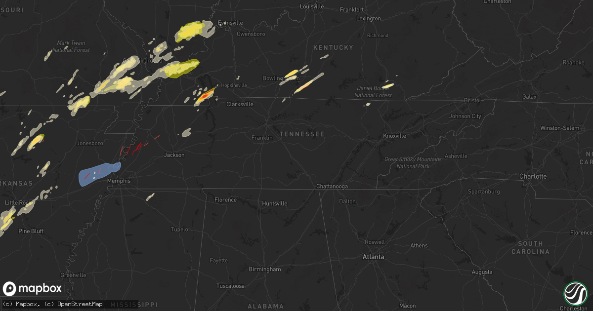
Hail Map in Tennessee on April 4, 2025
Get this storm
April 4 map
$229
one time, instant access
Download today. No call, no setup
Keep the $229
Bought the map and want the full workflow? Apply the entire $229 to a subscription within 7 days. None of it is wasted.
Every map, not just this one
This buys you this map. Subscription and you get every map we run, in the markets you choose from a few cities to whole states to nationwide. Plus real-time alerts the moment a storm fires.
Contact data
Name, contact info, occupancy, even credit band for addresses in the footprint. You go from where it hit to who to call.
Become the source they trust
Unlimited branding weather history reports on demand. You already have the documented answer ready for the property owner, and you are the one who showed up with it.
Property data and RoofTrace estimates
Pull up any address you have got, its value and the exact code rules for that jurisdiction, straight from One Click Code. Then RoofTrace estimates the squares, pitch, and roof value, priced the way you price.
Storm reports in Tennessee
Tennessee
| Date | Description |
|---|---|
| 04/04/20253:41 PM CDT | Report from mping: ping pong ball |
| 04/04/20255:22 AM CDT | Tree down on poplar grove road near the poplar grove cemetery. |
| 04/04/20255:19 AM CDT | Multiple trees down... Damaged home... And power outages near springville. Possibly associated with a tornado. |
| 04/04/20255:18 AM CDT | Tree down on a powerline at highway 641 and big sandy river road. |
| 04/04/20255:18 AM CDT | Home damaged on pleasant hill road. Grain truck and shed/barn demolished next door. |
| 04/04/20255:18 AM CDT | Tree down blocking roadway on pleasant hill road near springville. |
| 04/04/20253:56 AM CDT | House damaged on parks road near friendship. Possible tornado. |
| 04/04/20253:53 AM CDT | Lots of trees down on pugh road. Possible tornado. |
| 04/04/20253:52 AM CDT | Corrects previous tstm wnd dmg report from 2 s friendship. Shop damaged on east road. Possible tornado. |
| 04/04/20252:52 AM CDT | Shop damaged on east road. Possible tornado. |
All States Impacted by Hail Map on April 4, 2025
Cities Impacted by Hail Map on April 4, 2025
- Muskogee, OK
- Fort Gibson, OK
- Wagoner, OK
- Porter, OK
- Ozark, AR
- Mulberry, AR
- Pettigrew, AR
- Vernon, TX
- Parma, MO
- New Madrid, MO
- Matthews, MO
- Catron, MO
- Alton, MO
- Fremont, MO
- Essex, MO
- Van Buren, MO
- Springdale, AR
- Blair, OK
- Altus, OK
- Lone Wolf, OK
- Mangum, OK
- Oark, AR
- Powell, TX
- Mexia, TX
- Rockholds, KY
- Corbin, KY
- Kemp, TX
- Chatfield, TX
- Sulphur Springs, TX
- Williamsburg, KY
- Wortham, TX
- Richland, TX
- Woodbine, KY
- Greenville, TX
- Campbell, TX
- Cumby, TX
- Brashear, TX
- Dike, TX
- Summersville, MO
- Wills Point, TX
- Point, TX
- Corsicana, TX
- Kaufman, TX
- Mabank, TX
- Barbourville, KY
- Gray, KY
- Calico Rock, AR
- Norfork, AR
- Terrell, TX
- Hartshorn, MO
- Jadwin, MO
- Salem, MO
- Rice, TX
- Kerens, TX
- Sulphur Bluff, TX
- Deport, TX
- Bogata, TX
- Talco, TX
- Grand Saline, TX
- Fruitvale, TX
- Canton, TX
- Caulfield, MO
- Murray, KY
- Hazel, KY
- Edgewood, TX
- Trinidad, TX
- Bowling Green, KY
- Holly Springs, MS
- Farmington, KY
- Sedalia, KY
- Mayfield, KY
- Viola, AR
- Elizabeth, AR
- Puryear, TN
- Athens, TX
- Emory, TX
- Alba, TX
- Oakland, KY
- Smiths Grove, KY
- Lamar, MS
- Almo, KY
- Murchison, TX
- Cadiz, KY
- Sumner, TX
- Kenefic, OK
- Blossom, TX
- Bokchito, OK
- Bennington, OK
- Paris, TX
- Boswell, OK
- Detroit, TX
- Arthur City, TX
- Tishomingo, OK
- Mill Creek, OK
- Caddo, OK
- Powderly, TX
- Coleman, OK
- Clarksville, TX
- Milburn, OK
- Benton, KY
- Watts, OK
- Summers, AR
- Saltillo, TX
- Oneida, TN
- Park City, KY
- Rocky Hill, KY
- Ben Wheeler, TX
- Brownsboro, TX
- Colcord, OK
- Eustace, TX
- Van, TX
- Lindale, TX
- Tyler, TX
- Alvaton, KY
- Portland, TN
- Westmoreland, TN
- Bethpage, TN
- Chandler, TX
- Lowell, AR
- Siloam Springs, AR
- Winfield, TN
- Rogers, AR
- Cave Springs, AR
- Mount Vernon, TX
- Seligman, MO
- Adolphus, KY
- Scottsville, KY
- Dexter, KY
- Mineola, TX
- Cave City, KY
- Fountain Run, KY
- Austin, KY
- Hawkins, TX
- Mount Pleasant, TX
- Garfield, AR
- Horse Cave, KY
- Hardin, KY
- Hector, AR
- Glasgow, KY
- Etoile, KY
- Bunker, MO
- Annona, TX
- Witts Springs, AR
- Summer Shade, KY
- Eighty Eight, KY
- Winnsboro, TX
- Alpena, AR
- Avery, TX
- Big Sandy, TX
- Gilmer, TX
- Haworth, OK
- De Kalb, TX
- Pittsburg, TX
- Edmonton, KY
- Greensburg, KY
- Summersville, KY
- Campbellsville, KY
- Cecil, AR
- Charleston, AR
- Daingerfield, TX
- Pocahontas, AR
- Warm Springs, AR
- Foreman, AR
- De Queen, AR
- Ravenden Springs, AR
- Doniphan, MO
- Maynard, AR
- Hughes Springs, TX
- Omaha, TX
- Lone Star, TX
- Success, AR
- Naples, TX
- Oxly, MO
- Theodosia, MO
- Lockesburg, AR
- Clinton, AR
- Shirley, AR
- Winthrop, AR
- Mena, AR
- Fairdealing, MO
- Dierks, AR
- Gradyville, KY
- Fayetteville, AR
- Farmington, AR
- Bentonville, AR
- Ashdown, AR
- Alleene, AR
- Avinger, TX
- Thornfield, MO
- Noble, MO
- Ellington, MO
- Fox, AR
- Mountain View, AR
- Marietta, TX
- Douglassville, TX
- Wasola, MO
- Pelsor, AR
- Crofton, KY
- Dover, AR
- Hagarville, AR
- Newhope, AR
- Kirby, AR
- Glenwood, AR
- Langley, AR
- Harviell, MO
- Poplar Bluff, MO
- Prairie Grove, AR
- Linden, TX
- Caddo Gap, AR
- Bonnerdale, AR
- Norman, AR
- Melbourne, AR
- Amity, AR
- Des Arc, MO
- Nashville, AR
- Mineral Springs, AR
- Williamsville, MO
- Atlanta, TX
- Pineville, AR
- Maud, TX
- Ore City, TX
- Annapolis, MO
- Fredericktown, MO
- Mount Judea, AR
- Guion, AR
- Violet Hill, AR
- Franklin, AR
- Wappapello, MO
- Texarkana, TX
- Nash, TX
- Pleasant Grove, AR
- Batesville, AR
- Mount Pleasant, AR
- Horseshoe Bend, AR
- McGee, MO
- Aurora, MO
- Cassville, MO
- Purdy, MO
- Fifty Six, AR
- Verona, MO
- Puxico, MO
- Zalma, MO
- Marble Hill, MO
- Crane, MO
- Marionville, MO
- Murfreesboro, AR
- Sturdivant, MO
- Sage, AR
- Hardy, AR
- Cherokee Village, AR
- Ash Flat, AR
- Brownwood, MO
- Advance, MO
- Gipsy, MO
- Republic, MO
- Billings, MO
- Springfield, MO
- Bois D Arc, MO
- Couch, MO
- Gatewood, MO
- Queen City, TX
- Whitewater, MO
- Williford, AR
- Willard, MO
- Pleasant Hope, MO
- Fair Grove, MO
- Brighton, MO
- Greenville, MO
- Cape Girardeau, MO
- Jackson, MO
- Brazil, IN
- Brookline, MO
- Leopold, MO
- Bloomburg, TX
- Texarkana, AR
- Poland, IN
- Reelsville, IN
- Cloverdale, IN
- Fouke, AR
- Centerpoint, IN
- Bloomfield, MO
- Quincy, IN
- Martinsville, IN
- Flint, TX
- Garland City, AR
- Myrtle, MO
- Madison, IN
- Prim, AR
- Drasco, AR
- Deputy, IN
- Fillmore, IN
- Coatesville, IN
- Grandin, MO
- Glenallen, MO
- Oran, MO
- Burfordville, MO
- Naylor, MO
- Chaffee, MO
- Buffalo, MO
- Bullard, TX
- Hope, AR
- Elkland, MO
- Long Lane, MO
- Monrovia, IN
- Clayton, IN
- Stilesville, IN
- Mooresville, IN
- Fisk, MO
- Dupont, IN
- Broseley, MO
- Pomona, IL
- Alto Pass, IL
- Dudley, MO
- Whitehouse, TX
- Dexter, MO
- Anna, IL
- Carbondale, IL
- Makanda, IL
- Jonesboro, IL
- Wolf Lake, IL
- Winona, TX
- Tamms, IL
- Dongola, IL
- Cobden, IL
- Galena, MO
- Bell City, MO
- Idabel, OK
- Broken Bow, OK
- Horatio, AR
- Goreville, IL
- Buncombe, IL
- Ullin, IL
- Paris, TN
- Heavener, OK
- Howe, OK
- Eagletown, OK
- Gillham, AR
- Searcy, AR
- Sikeston, MO
- Watson, OK
- Gurdon, AR
- Vienna, IL
- Gladewater, TX
- Marion, IL
- Creal Springs, IL
- Stonefort, IL
- Cypress, IL
- Carrier Mills, IL
- Thompsonville, IL
- Galatia, IL
- Harrisburg, IL
- Raleigh, IL
- Wickes, AR
- Grannis, AR
- Cove, AR
- Equality, IL
- Eldorado, IL
- Broughton, IL
- Pittsburg, IL
- Judsonia, AR
- Ozark, IL
- Simpson, IL
- Pangburn, AR
- Bernie, MO
- Bertrand, MO
- East Prairie, MO
- Charleston, MO
- Ridgway, IL
- Norris City, IL
- Omaha, IL
- Junction, IL
- Donaldson, AR
- Arkadelphia, AR
- Bald Knob, AR
- Eddyville, IL
- Sabinal, TX
- Hatfield, AR
- Lebanon, OH
- Hamilton, OH
- Middletown, OH
- Monroe, OH
- New Haven, IL
- Shawneetown, IL
- Smithville, OK
- Malvern, AR
- Bradford, AR
- Cairo, IL
- Mountainburg, AR
- Boles, AR
- Morganfield, KY
- Mount Vernon, IN
- Waynesville, OH
- Franklin, OH
- Villa Ridge, IL
- Barlow, KY
- Traskwood, AR
- Oregonia, OH
- Mound City, IL
- Mounds, IL
- Olmsted, IL
- Springboro, OH
- Uniontown, KY
- Carmi, IL
- Waldron, AR
- Dayton, OH
- Bellbrook, OH
- Spring Valley, OH
- Winslow, AR
- Benton, AR
- Hodgen, OK
- Kevil, KY
- La Center, KY
- Grand Chain, IL
- Sparkman, AR
- Carthage, AR
- Leola, AR
- Xenia, OH
- Belknap, IL
- Parks, AR
- Evansville, IN
- La Pryor, TX
- Batesville, TX
- Wickliffe, KY
- Metropolis, IL
- Wilmington, OH
- Bauxite, AR
- Sheridan, AR
- Poyen, AR
- Prattsville, AR
- Karnak, IL
- Jamestown, OH
- Cedarville, OH
- Booneville, AR
- Mansfield, AR
- Big Lake, TX
- West Paducah, KY
- Golconda, IL
- Uvalde, TX
- Hindsville, AR
- Huntsville, AR
- Bryant, AR
- Alexander, AR
- Mabelvale, AR
- South Solon, OH
- South Charleston, OH
- Brookport, IL
- Ira, TX
- Colorado City, TX
- Wesley, AR
- Snyder, TX
- Knippa, TX
- Garden City, TX
- London, OH
- Paducah, KY
- Westbrook, TX
- Little Rock, AR
- Jeffersonville, OH
- Sterling City, TX
- Boaz, KY
- Hermleigh, TX
- Roscoe, TX
- Loraine, TX
- Smithland, KY
- Ledbetter, KY
- Burna, KY
- Tiline, KY
- Hampton, KY
- Salem, KY
- Mount Sterling, OH
- Anson, TX
- Merkel, TX
- Eureka Springs, AR
- Berryville, AR
- Roby, TX
- Rotan, TX
- Sweetwater, TX
- Yellow Springs, OH
- Springfield, OH
- Hawley, TX
- Hensley, AR
- Stamford, TX
- Leakey, TX
- Rio Frio, TX
- Concan, TX
- Utopia, TX
- Robert Lee, TX
- Hamlin, TX
- McCaulley, TX
- Sylvester, TX
- Scott, AR
- England, AR
- Ozona, TX
- Sabina, OH
- Carlsbad, TX
- Christoval, TX
- Rule, TX
- Haskell, TX
- Blackwell, TX
- Maryneal, TX
- Aspermont, TX
- San Angelo, TX
- Rocksprings, TX
- Mountain Home, TX
- Lonoke, AR
- Keo, AR
- Dryden, TX
- Brackettville, TX
- Junction, TX
- London, TX
- Del Rio, TX
- Weinert, TX
- Throckmorton, TX
- Carlisle, AR
- Hickory Plains, AR
- Des Arc, AR
- Branch, AR
- Ratcliff, AR
- Goodfellow Afb, TX
- Barnhart, TX
- Sonora, TX
- Menard, TX
- Eldorado, TX
- Camp Wood, TX
- Seymour, TX
- Goree, TX
- Nolan, TX
- Miles, TX
- Kirksey, KY
- Vandervoort, AR
- Hazen, AR
- Winters, TX
- Ovalo, TX
- Lawn, TX
- Tuscola, TX
- Barksdale, TX
- Vancourt, TX
- Wall, TX
- Eola, TX
- Mertzon, TX
- Altus, AR
- Clarksville, AR
- Griffithville, AR
- Abilene, TX
- Saint Paul, AR
- Vanderpool, TX
- Witter, AR
- Olney, TX
- Holliday, TX
- Clyde, TX
- Ballinger, TX
- Magazine, AR
- Rowena, TX
- Lavaca, AR
- Paris, AR
- Kingston, AR
- Ponca, AR
- Deer, AR
- Hunt, TX
- Medina, TX
- Electra, TX
- Comstock, TX
- Eden, TX
- Baird, TX
- Melvin, TX
- Brady, TX
- Green Forest, AR
- Talpa, TX
- Goldsboro, TX
- Compton, AR
- Wynne, AR
- Wichita Falls, TX
- Iowa Park, TX
- Ingram, TX
- Kerrville, TX
- Novice, TX
- Coleman, TX
- Sheppard Afb, TX
- Fredericksburg, TX
- Petrolia, TX
- Elkins, AR
- Combs, AR
- Paint Rock, TX
- Cisco, TX
- Moran, TX
- Harper, TX
- Newcastle, TX
- Henrietta, TX
- Colt, AR
- Palestine, AR
- Widener, AR
- Earle, AR
- Forrest City, AR
- Parkin, AR
- Cherry Valley, AR
- Crawfordsville, AR
- Tyronza, AR
- Turrell, AR
- Breckenridge, TX
- Byers, TX
- Randlett, OK
- Fort Smith, AR
- Gilmore, AR
- Ryan, OK
- Waurika, OK
- Grandfield, OK
- Burkburnett, TX
- Caddo, TX
- Ranger, TX
- Oden, AR
- Mount Ida, AR
- Hastings, OK
- Temple, OK
- Comanche, OK
- Doddridge, AR
- Marion, AR
- Memphis, TN
- Drummonds, TN
- Frenchmans Bayou, AR
- Ringling, OK
- Loco, OK
- Simms, TX
- Pencil Bluff, AR
- Sims, AR
- Duncan, OK
- Burgettstown, PA
- Healdton, OK
- Millington, TN
- Briggsville, AR
- Danville, AR
- Belleville, AR
- Springer, OK
- Graham, OK
- Ratliff City, OK
- Tussy, OK
- Wilson, OK
- Bluffton, AR
- Hartman, AR
- Subiaco, AR
- Scranton, AR
- New Boston, TX
- Osceola, AR
- Davis, OK
- Ardmore, OK
- Wynnewood, OK
- Foster, OK
- Hennepin, OK
- Elmore City, OK
- Willow City, TX
- Havana, AR
- Harrison, AR
- Henning, TN
- Ripley, TN
- Stratford, OK
- Sulphur, OK
- Pauls Valley, OK
- Dardanelle, AR
- Llano, TX
- New Concord, KY
- Gates, TN
- Delaware, AR
- Knoxville, AR
- Russellville, AR
- London, AR
- Ada, OK
- Wanette, OK
- Byars, OK
- Roff, OK
- Fitzhugh, OK
- Paoli, OK
- Lindsay, OK
- Maysville, OK
- Lexington, OK
- Wayne, OK
- Purcell, OK
- Asher, OK
- Friendship, TN
- Konawa, OK
- Macomb, OK
- Sasakwa, OK
- Cedar Hill, TX
- Holdenville, OK
- Wewoka, OK
- Maud, OK
- Allen, OK
- Atwood, OK
- Marlow, OK
- Dallas, TX
- Duncanville, TX
- Desoto, TX
- Calvin, OK
- Stuart, OK
- Bowlegs, OK
- Seminole, OK
- Wetumka, OK
- Okemah, OK
- Tecumseh, OK
- Earlsboro, OK
- Lamar, OK
- Dustin, OK
- Weleetka, OK
- Mcalester, OK
- Hanna, OK
- Milford, TX
- Atwood, TN
- Trezevant, TN
- Milan, TN
- Italy, TX
- Eufaula, OK
- Henryetta, OK
- Checotah, OK
- Council Hill, OK
- Okmulgee, OK
- Huntingdon, TN
- McKenzie, TN
- Bumpus Mills, TN
- Dover, TN
- Hopkinsville, KY
- Avoca, TX
- Lueders, TX


