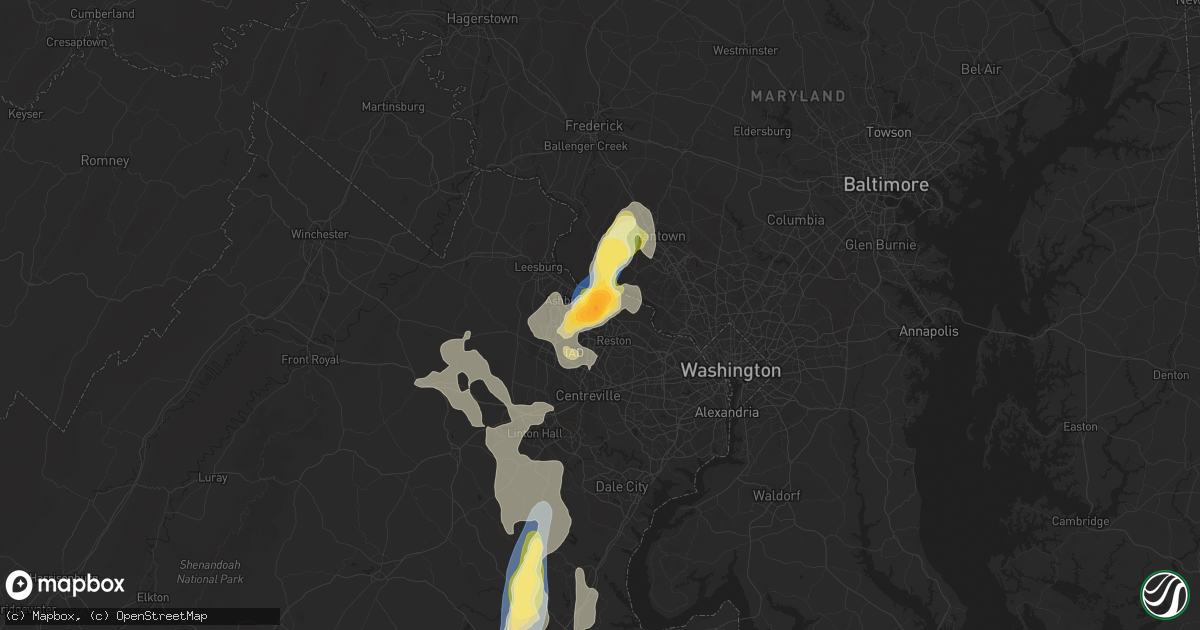
Hail Map in Sterling, VA on August 29, 2024
Get this storm
August 29 map
$229
one time, instant access
Download today. No call, no setup
Keep the $229
Bought the map and want the full workflow? Apply the entire $229 to a subscription within 7 days. None of it is wasted.
Every map, not just this one
This buys you this map. Subscription and you get every map we run, in the markets you choose from a few cities to whole states to nationwide. Plus real-time alerts the moment a storm fires.
Contact data
Name, contact info, occupancy, even credit band for addresses in the footprint. You go from where it hit to who to call.
Become the source they trust
Unlimited branding weather history reports on demand. You already have the documented answer ready for the property owner, and you are the one who showed up with it.
Property data and RoofTrace estimates
Pull up any address you have got, its value and the exact code rules for that jurisdiction, straight from One Click Code. Then RoofTrace estimates the squares, pitch, and roof value, priced the way you price.
Storm reports in Sterling, VA
Sterling, VA
| Date | Description |
|---|---|
| 08/29/20244:41 PM CDT | A tree down in yard in cascades area of sterling. |
| 08/29/20243:56 PM CDT | Ping pong ball sized hail near the intersection of algonkian pkwy and countryside blvd. |
| 08/29/20243:55 PM CDT | A local report indicates 1.75 inch wind near 2 N Sterling Park |
| 08/29/20243:54 PM CDT | Quarter sized hail in the cascades area of sterling. |
| 08/29/20243:51 PM CDT | Delayed report. Numerous reports recieved from public... Broadcast media showing hail up to at least 2 inches in diameter in the cascades area. Hail measured 2.3 inch o |
| 08/29/20243:48 PM CDT | Hail 2.5 inches in diameter reported on ridgetop circle in sterling. Numerous vehicles with broken windshields. |
| 08/29/20243:46 PM CDT | Quarter sized hail near the intersection of maries road and cascades parkway. |
| 08/29/20243:46 PM CDT | Quarter sized hail in the 100 block of cardinal glen circle. |
All States Impacted by Hail Map on August 29, 2024
All Cities Impacted by Hail Map on August 29, 2024
- Mandan, ND
- Menoken, ND
- Moffit, ND
- Sterling, ND
- Driscoll, ND
- Saint Anthony, ND
- Bismarck, ND
- Steele, ND
- Whitehouse Station, NJ
- Flemington, NJ
- Lebanon, NJ
- McLaughlin, SD
- Selfridge, ND
- Herreid, SD
- Mound City, SD
- Glenham, SD
- Eureka, SD
- Wakpala, SD
- Pollock, SD
- Strasburg, ND
- Fort Yates, ND
- Blackduck, MN
- Northome, MN
- Waskish, MN
- Mcintosh, MN
- Erskine, MN
- Ada, MN
- Gary, MN
- Fertile, MN
- Glade, KS
- Sadieville, KY
- Breese, IL
- Trenton, IL
- Coffeen, IL
- Fillmore, IL
- Piasa, IL
- Jerseyville, IL
- Gillespie, IL
- Cuba, MO
- Smithboro, IL
- Barnhart, MO
- Gray Summit, MO
- New Haven, MO
- Bethalto, IL
- Lovejoy, IL
- Valmeyer, IL
- Maryland Heights, MO
- Marthasville, MO
- Pacific, MO
- Belleville, IL
- Scott Air Force Base, IL
- Saint Louis, MO
- Washington, MO
- Roxana, IL
- Saint Jacob, IL
- Glen Carbon, IL
- Earth City, MO
- Portage Des Sioux, MO
- Valley Park, MO
- Dittmer, MO
- Golden Eagle, IL
- Waterloo, IL
- Wildwood, MO
- Lebanon, IL
- Germantown, IL
- Saint Ann, MO
- Panama, IL
- O'Fallon, MO
- Luebbering, MO
- Cedar Hill, MO
- Troy, IL
- Aviston, IL
- Grubville, MO
- Irving, IL
- Wright City, MO
- New Douglas, IL
- House Springs, MO
- Medora, IL
- Carlyle, IL
- East Alton, IL
- Fenton, MO
- Alton, IL
- New Baden, IL
- Carlinville, IL
- Shipman, IL
- Old Monroe, MO
- Saint Albans, MO
- Saint Clair, MO
- Lake Saint Louis, MO
- Union, MO
- Dorsey, IL
- Sorento, IL
- Fieldon, IL
- Columbia, IL
- Florissant, MO
- Foristell, MO
- Pevely, MO
- Lonedell, MO
- Ballwin, MO
- Benld, IL
- Mascoutah, IL
- Saint Peters, MO
- Grafton, IL
- Smithton, IL
- Fletcher, MO
- Bourbon, MO
- Edwardsville, IL
- West Alton, MO
- Alhambra, IL
- Freeburg, IL
- Sullivan, MO
- Bunker Hill, IL
- Donnellson, IL
- Brussels, IL
- Cottage Hills, IL
- Litchfield, IL
- Labadie, MO
- Elsah, IL
- Mount Olive, IL
- Wilsonville, IL
- Godfrey, IL
- Pocahontas, IL
- Brighton, IL
- Hazelwood, MO
- Granite City, IL
- Greenville, IL
- Worden, IL
- Defiance, MO
- Taylor Springs, IL
- Eureka, MO
- Beaufort, MO
- Moro, IL
- De Soto, MO
- Leslie, MO
- High Ridge, MO
- Saint Charles, MO
- Livingston, IL
- Bridgeton, MO
- Arnold, MO
- Mulberry Grove, IL
- Robertsville, MO
- South Roxana, IL
- Wentzville, MO
- Potosi, MO
- Walshville, IL
- Catawissa, MO
- Dow, IL
- Augusta, MO
- Dupo, IL
- Staunton, IL
- Imperial, MO
- Hartford, IL
- Fidelity, IL
- Summerfield, IL
- Sawyerville, IL
- Highland, IL
- Caseyville, IL
- Marine, IL
- Fairview Heights, IL
- East Carondelet, IL
- Collinsville, IL
- Madison, IL
- Millstadt, IL
- Butler, IL
- Hillsboro, IL
- Rosebud, MO
- Vandalia, IL
- Richwoods, MO
- Villa Ridge, MO
- Festus, MO
- Ramsey, IL
- Venice, IL
- New Athens, IL
- Witt, IL
- Hamel, IL
- East Saint Louis, IL
- Herculaneum, MO
- Chesterfield, MO
- Gerald, MO
- Maryville, IL
- Wood River, IL
- Crystal City, MO
- Keyesport, IL
- Hillsboro, MO
- O'Fallon, IL
- Fults, IL
- Owensville, MO
- Wagener, SC
- Shady Spring, WV
- Daniels, WV
- Stamping Ground, KY
- Cool Ridge, WV
- Phil Campbell, AL
- White Sulphur Springs, WV
- Hackleburg, AL
- Saint Matthews, SC
- Bolivar, MO
- Fair Play, MO
- Graysville, OH
- Russellville, AL
- Corinth, KY
- Haleyville, AL
- Dannebrog, NE
- Boelus, NE
- Hines, MN
- Motley, MN
- Mountain Lake, MN
- Campbell, NE
- Holstein, NE
- Comfrey, MN
- Sunburg, MN
- Kerkhoven, MN
- Raymond, MN
- Clara City, MN
- Albion, NE
- Petersburg, NE
- Saint Paul, NE
- Curwensville, PA
- Verndale, MN
- Glenwood, MN
- Starbuck, MN
- Benson, MN
- Sacred Heart, MN
- Bladen, NE
- Grand Island, NE
- Friedens, PA
- Central City, PA
- Sleepy Eye, MN
- Worthington, MN
- Round Lake, MN
- Brewster, MN
- Okabena, MN
- Staples, MN
- Berlin, PA
- Brooten, MN
- Pennock, MN
- Spicer, MN
- New London, MN
- Tilden, NE
- Bradley, SC
- Willmar, MN
- Greenwood, SC
- Prinsburg, MN
- Abbeville, SC
- Darfur, MN
- Lakefield, MN
- Meadow Grove, NE
- Orange City, IA
- Le Mars, IA
- McDowell, VA
- Oakdale, NE
- Neligh, NE
- Sauk Centre, MN
- Belgrade, MN
- Masterson, TX
- Kandiyohi, MN
- Clairton, PA
- South Park, PA
- Wingett Run, OH
- Parkers Prairie, MN
- Blue Grass, VA
- Carlisle, KY
- Ewing, KY
- New Ulm, MN
- Saint James, MN
- Finleyville, PA
- Doe Hill, VA
- Hanceville, AL
- Cullman, AL
- Panhandle, TX
- Amarillo, TX
- Fritch, TX
- Borger, TX
- Paynesville, MN
- Hillsboro, KY
- Elk Point, SD
- Lake Lillian, MN
- Cosmos, MN
- Grove City, MN
- Gove, KS
- Hanska, MN
- Waynesboro, GA
- Cairo, NE
- Alton, IA
- Centreville, VA
- Martinsburg, PA
- Roaring Spring, PA
- Clinton, IN
- Allen, NE
- Waterbury, NE
- Madison, NE
- Newman Grove, NE
- Wakefield, NE
- Moorefield, WV
- Sibley, IA
- Ashton, IA
- Palmer, NE
- Eden Valley, MN
- Litchfield, MN
- West Liberty, KY
- Oil Springs, KY
- Archer, IA
- Sheldon, IA
- Carroll, NE
- South Fork, PA
- Swanville, MN
- Kimball, MN
- Watkins, MN
- Hundred, WV
- Battle Creek, NE
- Norfolk, NE
- Mannington, WV
- Cedar Rapids, NE
- Saint Edward, NE
- Belgrade, NE
- Williamsville, VA
- Remsen, IA
- Metz, WV
- Hordville, NE
- Marquette, NE
- Moorefield, KY
- Wolbach, NE
- Terre Haute, IN
- Sterling, VA
- Ashburn, VA
- Saint Cloud, MN
- South Haven, MN
- Clearwater, MN
- Millboro, VA
- Deerfield, VA
- Young America, MN
- Water Valley, MS
- New Germany, MN
- Watertown, MN
- Mayer, MN
- Fullerton, NE
- Monticello, MN
- Plato, MN
- Sartell, MN
- Chantilly, VA
- Herndon, VA
- Clear Lake, MN
- Monroe, LA
- Gibbon, MN
- Winthrop, MN
- Lafayette, MN
- Courtland, MN
- Glencoe, MN
- Gaylord, MN
- Brownton, MN
- Green Isle, MN
- Arlington, MN
- New Auburn, MN
- Great Falls, VA
- Overland Park, KS
- Olathe, KS
- Poolesville, MD
- Stilwell, KS
- Treynor, IA
- Oakland, IA
- Silver City, IA
- Carson, IA
- Macedonia, IA
- Isonville, KY
- Sandy Hook, KY
- Salyersville, KY
- Eastaboga, AL
- Big Lake, MN
- Genoa, NE
- Oxford, MS
- Taylor, MS
- Pierce, NE
- Haymarket, VA
- Emerson, NE
- Concord, NE
- Dumas, MS
- Ripley, MS
- Becker, MN
- McBee, SC
- Hampton, NE
- Hamburg, MN
- Madelia, MN
- Warthen, GA
- Norwood Young America, MN
- Cologne, MN
- Garden City, KS
- Carlisle, PA
- Meyersdale, PA
- Washington, PA
- The Plains, VA
- Broad Run, VA
- Quinter, KS
- Princeton, MN
- Avon, MN
- Albany, MN
- Petersburg, WV
- Upper Tract, WV
- Park, KS
- Hill City, KS
- Sandersville, GA
- Tennille, GA
- Saint Joseph, MN
- Martha, KY
- Paullina, IA
- Cleghorn, IA
- Jasper, AL
- Clearwater, NE
- Boiling Springs, PA
- Boyds, MD
- Dickerson, MD
- Germantown, MD
- Bumpass, VA
- Partlow, VA
- Manassas, VA
- Beaverton, AL
- Gaithersburg, MD
- Malvern, IA
- Eighty Four, PA
- Ghent, KY
- Sioux City, IA
- Jefferson, SD
- Johnstown, PA
- Columbus, IN
- Rayle, GA
- Washington, GA
- Nauvoo, AL
- Herman, NE
- Tekamah, NE
- Little Sioux, IA
- Anoka, MN
- Champlin, MN
- Dayton, MN
- Osseo, MN
- Hamel, MN
- Maple Grove, MN
- Minneapolis, MN
- Rogers, MN
- Royalton, MN
- Little Falls, MN
- Marshall, VA
- Vernon Center, MN
- Christiansburg, VA
- Riner, VA
- Clifton, VA
- Booneville, MS
- Long Prairie, MN
- Gainesville, VA
- Oakton, VA
- Vienna, VA
- Potomac, MD
- Leesburg, VA
- Aldie, VA
- Andover, MN
- Cedar, MN
- Bethel, MN
- Saint Francis, MN
- Wyoming, MN
- Isanti, MN
- Stacy, MN
- Cambridge, MN
- North Branch, MN
- Harris, MN
- Forest Lake, MN
- Lindstrom, MN
- Chisago City, MN
- Grantsburg, WI
- Cushing, WI
- Rush City, MN
- Braham, MN
- Saint Croix Falls, WI
- Stanchfield, MN
- Center City, MN
- Pine City, MN
- Clay, WV
- Sugar Grove, VA
- Atkins, VA
- Marion, VA
- Spotsylvania, VA
- Stoystown, PA
- Shanksville, PA
- Dow City, IA
- Charter Oak, IA
- Harold, KY
- Betsy Layne, KY
- Ida Grove, IA
- Moatsville, WV
- Troutdale, VA
- Hazlehurst, MS
- Hermanville, MS
- Frederick, MD
- Mountain City, TN
- Amity, PA
- Prichard, WV
- Pikeville, KY
- Newburg, PA
- Barnesville, MD
- Grethel, KY
- Adamstown, MD
- New Richmond, WI
- Star Prairie, WI
- Odebolt, IA
- Arthur, IA
- Buckeystown, MD
- Clarksburg, MD
- Ijamsville, MD
- Blencoe, IA
- Saint Paul, MN
- Warrenton, VA
- Rush, KY
- Creston, NC
- Catharpin, VA
- Marcus, IA
- Sparkman, AR
- Farmington, MN
- Rosemount, MN
- Lakeville, MN
- Burnsville, MN
- Middleburg, VA
- Siren, WI
- Webster, WI
- Danbury, WI
- Frederic, WI
- Hinckley, MN
- Luck, WI
- Taylors Falls, MN
- Centuria, WI
- Shell Lake, WI
- Milltown, WI
- Hertel, WI
- Barronett, WI
- Spooner, WI
- Onawa, IA
- Osceola, WI
- Damascus, MD
- Nokesville, VA
- Shafer, MN
- Somerset, WI
- Catlettsburg, KY
- Fredericksburg, VA
- Gorham, KS
- Denison, IA
- Decatur, NE
- Louisa, KY
- Boise City, OK
- Felt, OK
- Kenova, WV
- Inver Grove Heights, MN
- Richardsville, VA
- Goldvein, VA
- Newville, PA
- San Jon, NM
- Whitetop, VA
- Bristow, VA
- Fairhope, PA
- Jeffersonton, VA
- Amissville, VA
- Mount Airy, MD
- Eatonton, GA
- Trade, TN
- Stafford, VA
- Sandstone, MN
- Midland, VA
- Catlett, VA
- Quantico, VA
- Sutton, WV
- Garrett, PA
- Mount Savage, MD
- Hyndman, PA
- Salisbury, PA
- Saint Paul Park, MN
- Philippi, WV
- Lock Haven, PA
- Mill Hall, PA
- Beech Creek, PA
- River Falls, WI
- Baldwin, WI
- Townley, AL
- Carbon Hill, AL
- Cottage Grove, MN
- Lansing, NC
- Troy, SC
- Southern Pines, NC
- Trafford, AL
- Zionville, NC
- Woodville, WI
- Wilson, WI
- Terra Alta, WV
- Buffalo Mills, PA
- Grassy Creek, NC
- Crumpler, NC
- Independence, VA
- Mouth Of Wilson, VA
- Piney Creek, NC
- Loganton, PA
- Beldenville, WI
- Spring Valley, WI
- Hammond, WI
- Danbury, IA
- Battle Creek, IA
- Mapleton, IA
- Marathon, TX
- Procious, WV
- Greenville, GA
- Knapp, WI
- Boones Mill, VA
- Glenwood City, WI
- Boyceville, WI
- Downing, WI
- Elmwood, WI
- Menomonie, WI
- Elk Mound, WI
- Howard, PA
- Canonsburg, PA
- Vardaman, MS
- Cowen, WV
- Allison, IA
- Greene, IA
- Hastings, MN
- Wheeler, WI
- Colfax, WI
- Madisonburg, PA
- Rebersburg, PA
- Aaronsburg, PA
- Bristow, IA
- Draper, VA
- Hillsville, VA
- Barren Springs, VA
- Max Meadows, VA
- Warrior, AL
- Hudson, WI
- Roberts, WI
- Pinson, AL
- Bloomer, WI
- Eau Claire, WI
- Fall Creek, WI
- Altoona, WI
- Chippewa Falls, WI
- Fort Ashby, WV
- Keyser, WV
- Ridgeley, WV
- Cumberland, MD
- Springfield, WV
- Oldtown, MD
- Romney, WV
- Burlington, WV
- Ripley, TN
- Maiden Rock, WI
- Bay City, WI
- Moneta, VA
- Rocky Mount, VA
- Stockholm, WI
- Birmingham, AL
- Ellsworth, WI
- Gray, GA
- Wirtz, VA
- Lake City, MN
- Milam, WV
- New Hampton, IA
- Monticello, GA
- Hillsboro, GA
- Colwell, IA
- Orchard, IA
- Alta Vista, IA
- Charles City, IA
- Floyd, IA
- Dry Branch, GA
- Macon, GA
- Wakeeney, KS
- Ionia, IA
- Elma, IA
- Riceville, IA
- Osage, IA
- Cresco, IA
- Ridgeway, IA
- Lime Springs, IA
- Chester, IA
- Spring Valley, MN
- Preston, MN
- Le Roy, MN
- Harmony, MN
- Decorah, IA
- Lanesboro, MN
- Canton, MN
- Mabel, MN
- Peterson, MN
- Plum City, WI
- Loganville, GA
- Milroy, PA
- Winside, NE
- Monroe, GA
- Arkansaw, WI
- Oxford, GA
- Covington, GA
- Warm Springs, GA
- Collyer, KS
- Nelson, WI
- Reads Landing, MN
- Wabasha, MN
- Wykoff, MN
- Singers Glen, VA
- Harrisonburg, VA
- Mondovi, WI
- Alpharetta, GA
- Duluth, GA
- Cumming, GA
- Shiloh, GA
- Roswell, GA
- Spring Grove, MN
- Houston, MN
- Caledonia, MN
- Rushford, MN
- Hokah, MN
- Brownsville, MN
- Fountain, MN
- Stephens City, VA
- Peachtree Corners, GA
- Front Royal, VA
- Rawlings, MD
- Calmar, IA
- Fort Atkinson, IA
- Protivin, IA
- Stoddard, WI
- Genoa, WI
- La Crescent, MN
- La Crosse, WI
- Glade Hill, VA
- Huddleston, VA
- Union Hall, VA
- Hardy, VA
- Penhook, VA
- Sandy Level, VA
- Pittsville, VA
- Bedford, VA
- Lynch Station, VA
- Evington, VA
- Hurt, VA
- Altavista, VA
- Gladys, VA
- Long Island, VA
- Brookneal, VA
- Dorchester, IA
- Winchester, VA
- White Post, VA
- Middletown, VA
- Phenix, VA
- Charlotte Court House, VA
- Millheim, PA
- Spring Mills, PA
- Coburn, PA
- Augusta, WV
- Bruceton Mills, WV
- High View, WV
- Capon Bridge, WV
- Slanesville, WV
- Paw Paw, WV
- Porterville, MS
- Woodward, PA
- Carver, MN
- Shakopee, MN
- Humphrey, NE
- Excelsior, MN
- Clovis, NM
- Indianapolis, IN
- Beech Grove, IN
- Prior Lake, MN
- Savage, MN
- Chanhassen, MN
- Chaska, MN
- Monroe, NE
- Quinwood, WV
- Mount Lookout, WV
- Pool, WV
- Mount Nebo, WV
- Nallen, WV
- Anniston, AL
- Blytheville, AR
- New Albin, IA
- Marietta, OH
- Dighton, KS
- Healy, KS
- Elkfork, KY
- Eden Prairie, MN
- Akeley, MN
- Manter, KS
- Webbville, KY
- Meade, KS
- Elkhart, KS
- Franklin, NC
- Morehead, KY
- Lakin, KS
- Eagle Rock, VA
- Ulysses, KS
- Holcomb, KS
- Grinnell, KS
- Syracuse, KS
- Kendall, KS
- Milford, NE
- Dorchester, NE
- Bard, NM
- Easley, SC
- Fort Gay, WV
- Lexington, GA
- Victoria, KS
- Mineral Point, WI
- Dodgeville, WI
- Barneveld, WI
- Ridgeway, WI
- Blue Mounds, WI
- Mount Horeb, WI
- Verona, WI
- McClure, PA
- Little Birch, WV
- Duck, WV
- Meadow Bridge, WV
- Danese, WV
- Wytheville, VA
- Scott City, KS
- Ute, IA
- Schleswig, IA
- Beaver Springs, PA
- Utica, KS
- Scranton, IA
- Jefferson, IA
- Kiron, IA
- Dresser, WI
- Durand, WI
- Jordan, MN
- Maynard, MN
- Craig, NE
- Lyons, NE
- Oakland, NE
- Manchester, GA
- Amery, WI
- Buffalo, MN
- Maple Lake, MN
- Brownsburg, IN
- Springfield, MN
- Atwater, MN
- Sauk Rapids, MN
- Wadena, MN
- Rice, MN
- Holdingford, MN
- Murdock, MN
- Arcadia, WI
- Bowlus, MN
- Garden City, MN
- Grey Eagle, MN
- Stephens, GA
- Waucoma, IA
- Freeport, MN
- Rogers, NM
- Minden, IA
- McClelland, IA
- Dunlap, IA
- Henderson, IA
- Olin, IA
- Anamosa, IA
- Melrose, NM
- Delaplane, VA
- Woden, IA
- Bellevue, IA
- Hull, GA
- McIntire, IA
- Little Cedar, IA
- Stacyville, IA
- Mifflinburg, PA
- Monmouth, IA
- Wesley, IA
- Jacksons Gap, AL
- Maquoketa, IA
- Baldwin, IA
- La Motte, IA
- Titonka, IA
- Callaway, VA
- Dumont, IA
- Alexander City, AL
- Lost Nation, IA
- Kellogg, MN
- McGregor, IA
- Monona, IA
- McAlisterville, PA
- Richfield, PA
- Mifflintown, PA
- Zwingle, IA
- Aplington, IA
- Roseland, VA
- Tyro, VA
- Delmar, IA
- Amherst, VA
- Oakland Mills, PA
- Buena Vista, VA
- Prairie Du Chien, WI
- Alma, WI
- Monroe, VA
- Harpers Ferry, IA
- Thompsontown, PA
- Eastman, WI
- Port Royal, PA
- Churdan, IA
- Elizabeth, IL
- Hanover, IL
- Galena, IL
- Trempealeau, WI
- Galesville, WI
- Dodge, WI
- Buckingham, VA
- Charlotte, IA
- Sublette, KS
- Millerstown, PA
- Wyoming, IA
- Oxford Junction, IA
- Vesuvius, VA
- Center Junction, IA
- Onslow, IA
- Ruckersville, VA
- Stanardsville, VA
- Lehigh, IA
- Dayton, IA
- Charlottesville, VA
- Barboursville, VA
- Portales, NM
- Gretna, VA
- Aroda, VA
- Rochelle, VA
- Grand Mound, IA
- Mineral, VA
- Kents Store, VA
- Goochland, VA
- Powhatan, VA
- Palmyra, VA
- Keysville, VA
- Meherrin, VA
- Midlothian, VA
- Manakin Sabot, VA
- Lexington, VA
- Rawlings, VA
- Alberta, VA
- Blackstone, VA
- Wilsons, VA
- Amelia Court House, VA
- Jetersville, VA
- Cullen, VA
- Farmville, VA
- Petersburg, VA
- Pierceville, KS
- Spring Green, WI
- Black Earth, WI
- Cross Plains, WI
- Hampton, AR
- Camden, AR
- Avoca, WI
- Arena, WI
- Lagrange, GA
- Rutledge, GA
- Social Circle, GA
- Elora, TN
- Flintville, TN
- Kelso, TN
- Fayetteville, TN
- Prescott, WI


