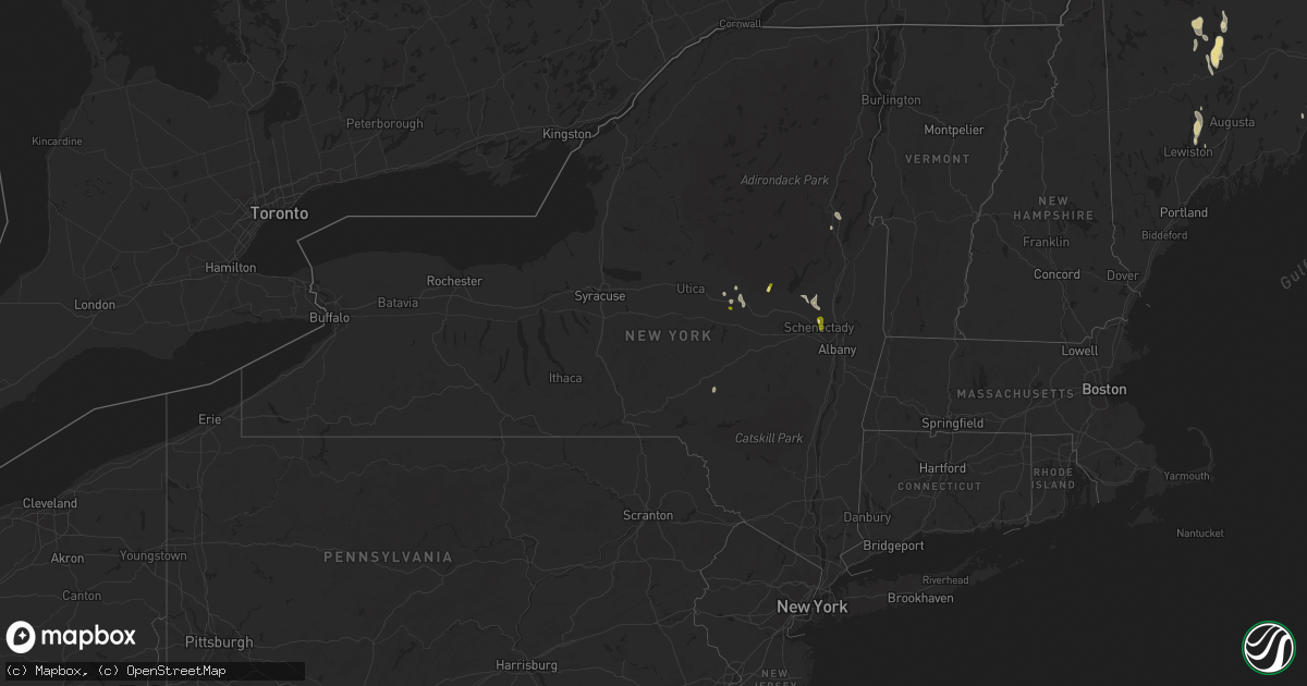
Hail Map in New York on August 14, 2024
Get this storm
August 14 map
$229
one time, instant access
Download today. No call, no setup
Keep the $229
Bought the map and want the full workflow? Apply the entire $229 to a subscription within 7 days. None of it is wasted.
Every map, not just this one
This buys you this map. Subscription and you get every map we run, in the markets you choose from a few cities to whole states to nationwide. Plus real-time alerts the moment a storm fires.
Contact data
Name, contact info, occupancy, even credit band for addresses in the footprint. You go from where it hit to who to call.
Become the source they trust
Unlimited branding weather history reports on demand. You already have the documented answer ready for the property owner, and you are the one who showed up with it.
Property data and RoofTrace estimates
Pull up any address you have got, its value and the exact code rules for that jurisdiction, straight from One Click Code. Then RoofTrace estimates the squares, pitch, and roof value, priced the way you price.
Storm reports in New York
New York
| Date | Description |
|---|---|
| 08/14/20244:02 PM CDT | Several trees down on us route 9 near spruce mountain between warrensburg and chestertown. Time estimated from radar. |
| 08/14/20244:02 PM CDT | Multiple trees uprooted. Penny-sized hail also reported. Time estimated from radar. |
| 08/14/20243:18 PM CDT | Tree down state highway 10 in delhi |
| 08/14/20242:59 PM CDT | Tree down in the herkimer walmart parking lot. Time estimated from radar. |
| 08/14/20242:50 PM CDT | Received a report of trees down between 3 pm and 4 pm. Time estimated by radar. |
| 08/14/20242:35 PM CDT | Received reports of trees and wires down near charlton road between 3 pm and 4 pm. |
| 08/14/20242:29 PM CDT | Measured quarter size hail at time of reporting. |
| 08/14/20242:15 PM CDT | Firefighter reported about 40 downed trees near dutch hill road. |
| 08/14/20242:15 PM CDT | Max winds 80 mph. Path length .1 miles... Width 175 yards. |
| 08/14/20242:12 PM CDT | Received report of trees down. Time estimated by radar. |
| 08/14/20242:02 PM CDT | 911 call center received reports of trees and wires down in dolgeville. Time estimated on radar. |
| 08/14/20242:00 PM CDT | 911 call center received report of trees down along ny 29 in galway. Time based on radar. |
| 08/14/20242:00 PM CDT | Flat... Rubber type roof blown off of a house in dolgeville and landed in the back yard. Time estimated from radar. |
All States Impacted by Hail Map on August 14, 2024
Cities Impacted by Hail Map on August 14, 2024
- Meadville, MO
- Dalton, MO
- Fayette, MO
- Keytesville, MO
- Brunswick, MO
- Galway, NY
- Rock City Falls, NY
- Middle Grove, NY
- Broadalbin, NY
- Ballston Spa, NY
- Dolgeville, NY
- Franklin, ME
- Hagaman, NY
- Saint Johnsville, NY
- Amsterdam, NY
- Ballston Lake, NY
- Little Falls, NY
- Herkimer, NY
- Flora, MS
- Canton, MS
- Thermopolis, WY
- Madison, MS
- Rolling Fork, MS
- Schenectady, NY
- Alplaus, NY
- Ridgeland, MS
- Gloversville, NY
- East Meredith, NY
- Meridale, NY
- Fort Stockton, TX
- Rawlins, WY
- Jeffrey City, WY
- Delhi, NY
- Mohawk, NY
- Warrensburg, NY
- Chestertown, NY
- Mobile, AL
- Brant Lake, NY
- Dupree, SD
- Bolton Landing, NY
- Fort Bridger, WY
- Mountain View, WY
- Morrill, ME
- Belfast, ME
- Wamsutter, WY
- Daphne, AL
- Fairhope, AL
- Boulder, CO
- Lafayette, CO
- Lincolnville, ME
- Erie, CO
- Tallulah, LA
- Happy, TX
- Canyon, TX
- Dacono, CO
- Vancleave, MS
- Mobridge, SD
- Bingham, ME
- Fort Pierre, SD
- Hayes, SD
- Glenham, SD
- Bennington, KS
- Minneapolis, KS
- North Anson, ME
- Kinsley, KS
- Solon, ME
- Linn, KS
- Saucier, MS
- Palmer, KS
- Anson, ME
- Murdo, SD
- Selby, SD
- Clifton, KS
- Chase, KS
- Washington, KS
- Lyons, KS
- Larned, KS
- Greenleaf, KS
- Clay Center, KS
- Morganville, KS
- Fort Plain, NY
- Madison, ME
- Norridgewock, ME
- Lewis, KS
- Draper, SD
- Ellinwood, KS
- Hollenberg, KS
- Hanover, KS
- Geneseo, KS
- Barnes, KS
- Blunt, SD
- Seagraves, TX
- Presho, SD
- Vivian, SD
- Marquette, KS
- Odell, NE
- Diller, NE
- Steele City, NE
- Harrold, SD
- Belpre, KS
- Gulfport, MS
- Green, KS
- Pierre, SD
- Blue Springs, NE
- Randolph, KS
- Wymore, NE
- Waterville, KS
- Pass Christian, MS
- Tescott, KS
- Diamondhead, MS
- Great Bend, KS
- Beatrice, NE
- Franklinton, LA
- Claflin, KS
- Bremen, KS
- Filley, NE
- Crab Orchard, NE
- Holyrood, KS
- Lorraine, KS
- Ellsworth, KS
- Kanopolis, KS
- Blue Rapids, KS
- Marysville, KS
- Tulia, TX
- Burchard, NE
- Leeds, ME
- North Monmouth, ME
- Livermore Falls, ME
- Wayne, ME
- Arnegard, ND
- Lincoln, KS
- Adams, NE
- Tecumseh, NE
- Sterling, NE
- Olsburg, KS
- Mcpherson, KS
- Oacoma, SD
- Reliance, SD
- Westmoreland, KS
- Picayune, MS
- Miltonvale, KS
- Delphos, KS
- Steinauer, NE
- Burr, NE
- Cook, NE
- Pawnee City, NE
- Greene, ME
- Syracuse, NE
- Leonardville, KS
- Brock, NE
- Chamberlain, SD
- Frankfort, KS
- Onaga, KS
- Concordia, KS
- Table Rock, NE
- Elk Creek, NE
- Johnson, NE
- Humboldt, NE
- Talmage, NE
- Riley, KS
- Manhattan, KS
- Aurora, KS
- Nebraska City, NE
- Peru, NE
- Auburn, NE
- Julian, NE
- Home, KS
- Clyde, KS
- Inman, KS
- Galva, KS
- Hillsboro, KS
- Canton, KS
- Lehigh, KS
- Gregory, SD
- Platte, SD
- Rock Port, MO
- Pukwana, SD
- Haviland, KS
- Tampa, KS
- Marion, KS
- Burke, SD
- Saint George, KS
- Vermillion, KS
- Falls City, NE
- Verdon, NE
- Brownville, NE
- Nemaha, NE
- Stella, NE
- Shubert, NE
- Watson, MO
- Fairfax, MO
- Craig, MO
- Blanchard, IA
- Tarkio, MO
- Riverton, IA
- Shenandoah, IA
- Westboro, MO
- Farragut, IA
- Hamburg, IA
- Coin, IA
- Northboro, IA
- Kimball, SD
- Whitney, NE
- Herington, KS
- Wamego, KS
- Corning, KS
- Chadron, NE
- Lincolnville, KS
- Centralia, KS
- Burrton, KS
- Wahoo, NE
- Mead, NE
- Yutan, NE
- Ashland, NE
- Ithaca, NE
- Havensville, KS
- College Springs, IA
- Clearmont, MO
- Burlington Junction, MO
- Maryville, MO
- Clarinda, IA
- Skidmore, MO
- Elmo, MO
- Braddyville, IA
- Hopkins, MO
- Bedford, IA
- Gravity, IA
- Yorktown, IA
- Pickering, MO
- New Market, IA
- Shambaugh, IA
- Hay Springs, NE
- Dwight, KS
- Council Grove, KS
- Alta Vista, KS
- Axtell, KS
- Belvue, KS
- Halstead, KS
- Hesston, KS
- Jackman, ME
- Newton, KS
- Walton, KS
- Junction City, KS
- Alma, KS
- White City, KS
- Peabody, KS
- Arlington, CO
- Creston, IA
- Orient, IA
- Emmett, KS
- Saint Marys, KS
- Paxico, KS
- Geddes, SD
- Haven, KS
- Omaha, NE
- Delia, KS
- Florence, KS
- Rushville, NE
- Eskridge, KS
- Harveyville, KS
- Mount Hope, KS
- Sedgwick, KS
- Las Animas, CO
- Mayetta, KS
- Topeka, KS
- Maple Hill, KS
- La Vista, NE
- Moundridge, KS
- Rossville, KS
- Goff, KS
- Wetmore, KS
- Holton, KS
- Whiting, KS
- Everest, KS
- Soldier, KS
- Circleville, KS
- Horton, KS
- Netawaka, KS
- Denton, KS
- Amazonia, MO
- Hiawatha, KS
- Bendena, KS
- Highland, KS
- Troy, KS
- Wathena, KS
- Powhattan, KS
- Robinson, KS
- Oregon, MO
- White Cloud, KS
- Fairview, KS
- Seneca, KS
- Sabetha, KS
- Forest City, MO
- McClave, CO
- Northville, NY
- Fairfax, SD
- Silver Lake, KS
- Caroga Lake, NY
- Andale, KS
- Colwich, KS
- Cheney, KS
- Cedar Point, KS
- Muscotah, KS
- Lancaster, KS
- Hope, KS
- Bentley, KS
- Valley Center, KS
- Maize, KS
- Bristow, NE
- Spencer, NE
- Lynch, NE
- Whitewater, KS
- Garden Plain, KS
- Enterprise, KS
- Wichita, KS
- Swanton, VT
- Saint Albans, VT
- Kents Hill, ME
- Sabattus, ME
- Emporia, KS
- New Portland, ME
- Kechi, KS
- Greenwich, KS
- Auburn, KS
- Tecumseh, KS
- Oskaloosa, KS
- Lecompton, KS
- Tonganoxie, KS
- Perry, KS
- Basehor, KS
- Leavenworth, KS
- McLouth, KS
- Lansing, KS
- Platte City, MO
- Grantville, KS
- Weston, MO
- Meriden, KS
- Easton, KS
- Fort Leavenworth, KS
- Ozawkie, KS
- Valley Falls, KS
- Winchester, KS
- Kansas City, MO
- Waldron, MO
- Kansas City, KS
- Farley, MO
- Smithville, MO
- Burns, KS
- Towanda, KS
- Potwin, KS
- Elbing, KS
- Cassoday, KS
- El Dorado, KS
- Benton, KS
- North Newton, KS
- Kingman, KS
- Murdock, KS
- Goddard, KS
- Farmington, ME
- Hoyt, KS
- Augusta, KS
- Andover, KS
- New Sharon, ME
- Lebo, KS
- Derby, KS
- Clearwater, KS
- Mcconnell Afb, KS
- Douglass, KS
- Rose Hill, KS
- Waverly, KS
- Melvern, KS
- Maitland, MO
- Mound City, MO
- Barnard, MO
- Haysville, KS
- Bolckow, MO
- Rosendale, MO
- Graham, MO
- Kingfield, ME
- King City, MO
- Stanberry, MO
- Leon, KS
- Higbee, MO
- Strong, ME
- New Vineyard, ME
- Buffalo Gap, SD
- Custer, SD
- Cedar Vale, KS
- Eureka, KS
- Severy, KS
- Piedmont, KS
- Toronto, KS
- Altoona, KS
- Fredonia, KS
- Thayer, KS
- Tuthill, SD
- Freeburg, IL


