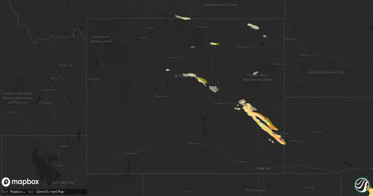
Hail Map in Wyoming on September 9, 2023
Get this storm
September 9 map
$229
one time, instant access
Download today. No call, no setup
Keep the $229
Bought the map and want the full workflow? Apply the entire $229 to a subscription within 7 days. None of it is wasted.
Every map, not just this one
This buys you this map. Subscription and you get every map we run, in the markets you choose from a few cities to whole states to nationwide. Plus real-time alerts the moment a storm fires.
Contact data
Name, contact info, occupancy, even credit band for addresses in the footprint. You go from where it hit to who to call.
Become the source they trust
Unlimited branding weather history reports on demand. You already have the documented answer ready for the property owner, and you are the one who showed up with it.
Property data and RoofTrace estimates
Pull up any address you have got, its value and the exact code rules for that jurisdiction, straight from One Click Code. Then RoofTrace estimates the squares, pitch, and roof value, priced the way you price.
Storm reports in Wyoming
Wyoming
| Date | Description |
|---|---|
| 09/09/20231:06 AM CDT | Hail accumulating to several inches deep. |
| 09/09/20231:00 AM CDT | A local report indicates 1.00 inch wind near Yoder |
| 09/09/202312:46 AM CDT | Roads covered in hail accumulation. Largest hailstone was golf ball sized. |
| 09/08/202310:45 PM CDT | Emergency manager reported 2.8 inch hail relayed from dan fitts. |
| 09/08/202310:35 PM CDT | All large hail. Very little rainfall. |
| 09/08/202310:26 PM CDT | Golf ball hail at mile marker 34 on highway 26 between fort laramie and lingle. |
| 09/08/202310:25 PM CDT | Report from mping: half dollar |
| 09/08/202310:19 PM CDT | Spotter reported 2 inch hail ongoing. Started at 911pm. |
| 09/08/202310:00 PM CDT | Golfball to baseball sized hail. |
| 09/08/202310:00 PM CDT | Possible roof damage from hail around 9pm. |
| 09/08/20239:58 PM CDT | A local report indicates 1.75 inch wind near 4 N Fort Laramie |
| 09/08/20239:58 PM CDT | Report from mping: ping pong ball |
| 09/08/20238:30 PM CDT | Platte/converse county line wydot sensor and webcam. Hail covering interstate 25. Observation had zero visibility with heavy rain and wind gusts to 51 mph. |
All States Impacted by Hail Map on September 9, 2023
Cities Impacted by Hail Map on September 9, 2023
- Wood Lake, NE
- Johnstown, NE
- Ainsworth, NE
- Valentine, NE
- Saint Francis, SD
- Mission, SD
- Princeton, WV
- Glen Lyn, VA
- Narrows, VA
- Groesbeck, TX
- Thornton, TX
- Emporia, VA
- Montrose, WV
- Belington, WV
- Bassett, NE
- Newport, NE
- East Brunswick, NJ
- North Brunswick, NJ
- Milltown, NJ
- New Brunswick, NJ
- Somerset, NJ
- Arnold, NE
- Garfield, NJ
- Elmwood Park, NJ
- Saddle Brook, NJ
- Lodi, NJ
- Anselmo, NE
- Stapleton, NE
- Somerdale, NJ
- Blackwood, NJ
- Magnolia, NJ
- Voorhees, NJ
- Merna, NE
- Boswell, PA
- Laughlintown, PA
- Ligonier, PA
- Mount Tabor, NJ
- Morris Plains, NJ
- Denville, NJ
- Parsippany, NJ
- Bellefonte, PA
- Callaway, NE
- Howard, PA
- Blanchard, PA
- Beech Creek, PA
- Mill Hall, PA
- Broken Bow, NE
- Oconto, NE
- Sweet Valley, PA
- Benton, PA
- Hunlock Creek, PA
- Shickshinny, PA
- Lock Haven, PA
- De Leon, TX
- Comanche, TX
- Windsor, CT
- South Windsor, CT
- Coleman, TX
- Hop Bottom, PA
- Kingsley, PA
- Bay City, TX
- Palacios, TX
- Cozad, NE
- Lexington, NE
- Gothenburg, NE
- New Milford, PA
- Montrose, PA
- Clarks Summit, PA
- Dalton, PA
- Waverly, PA
- Factoryville, PA
- Tunkhannock, PA
- Falls, PA
- Pittston, PA
- North Platte, NE
- Maxwell, NE
- Olyphant, PA
- Jermyn, PA
- Hallstead, PA
- Wellfleet, NE
- Saint Francis, KS
- Talpa, TX
- Ballinger, TX
- Arapahoe, CO
- Cheyenne Wells, CO
- Brady, NE
- Moorefield, NE
- Curtis, NE
- Maywood, NE
- Andover, NJ
- Hackettstown, NJ
- Great Meadows, NJ
- Mechanicsville, MD
- Philipsburg, PA
- Hopatcong, NJ
- Stanhope, NJ
- Princeton, NJ
- Kendall Park, NJ
- Monmouth Junction, NJ
- Haymarket, VA
- Aldie, VA
- Petersburg, PA
- Morristown, NJ
- Mount Nebo, WV
- Nallen, WV
- Quinwood, WV
- Hico, WV
- Greenwood, DE
- Bridgeville, DE
- Hollywood, AL
- King William, VA
- Union Bridge, MD
- Woodsboro, MD
- McClure, VA
- Coeburn, VA
- Passaic, NJ
- Clifton, NJ
- Paterson, NJ
- Piscataway, NJ
- Monroe Township, NJ
- Highland Park, NJ
- Englishtown, NJ
- Newton, NJ
- Blairstown, NJ
- Mountain Lakes, NJ
- Linden, PA
- Tyrone, PA
- Warriors Mark, PA
- Pottersdale, PA
- Soddy Daisy, TN
- Sale Creek, TN
- Rock Creek, WV
- Dry Creek, WV
- Sandy Ridge, PA
- Osceola Mills, PA
- Prince Frederick, MD
- Port Republic, MD
- Luthersburg, PA
- Seaford, DE
- Cooksville, MD
- Sykesville, MD
- Woodbine, MD
- Leesburg, VA
- Paeonian Springs, VA
- Ruther Glen, VA
- Beaverdam, VA
- Spotsylvania, VA
- Waterford, VA
- Hamilton, VA
- Lovettsville, VA
- Florham Park, NJ
- Short Hills, NJ
- Chatham, NJ
- Madison, NJ
- Green Village, NJ
- Rockaway, NJ
- Whippany, NJ
- East Hanover, NJ
- Cedar Knolls, NJ
- Livingston, NJ
- Saint Charles, VA
- Pennington Gap, VA
- Stuart, NE
- Georgetown, DE
- Tellico Plains, TN
- Columbia, NJ
- Temple Hills, MD
- Suitland, MD
- Culpeper, VA
- Emmitsburg, MD
- Rocky Ridge, MD
- Thurmont, MD
- Hulett, WY
- Moorcroft, WY
- Totowa, NJ
- Little Falls, NJ
- Oak Hall, VA
- Scotland Neck, NC
- Clementon, NJ
- New Florence, PA
- Sterling, VA
- Runnemede, NJ
- Barrington, NJ
- Glendora, NJ
- Stratford, NJ
- Thermopolis, WY
- Scotland, MD
- Tall Timbers, MD
- Piney Point, MD
- Lottsburg, VA
- Kinsale, VA
- Mcminnville, TN
- Rock Island, TN
- Crozier, VA
- Upper Marlboro, MD
- Andrews Air Force Base, MD
- Maryville, TN
- Greenback, TN
- Atkinson, NE
- Clinton, TN
- Flintstone, MD
- Little Orleans, MD
- Artemas, PA
- Gloucester City, NJ
- Bellmawr, NJ
- Sewell, NJ
- Westville, NJ
- Woodbury, NJ
- Dublin, TX
- Warrenton, VA
- Milesburg, PA
- Dunning, NE
- Helmetta, NJ
- Edison, NJ
- Dunellen, NJ
- Middlesex, NJ
- Spotswood, NJ
- Accokeek, MD
- Randolph, NJ
- Wharton, NJ
- Dover, NJ
- Finksburg, MD
- Harrington, DE
- Huntingtown, MD
- Cumberland, RI
- Plainville, MA
- North Attleboro, MA
- Damascus, MD
- Clarksburg, MD
- Pennsylvania Furnace, PA
- Port Matilda, PA
- Herndon, VA
- Petersburg, WV
- Cammal, PA
- Smithwick, SD
- Hot Springs, SD
- Smithfield, VA
- Cabins, WV
- Upper Tract, WV
- Maysville, WV
- Oxon Hill, MD
- District Heights, MD
- Fort Washington, MD
- Weston, WY
- Custer, SD
- Julian, PA
- Fackler, AL
- La Follette, TN
- Jacksboro, TN
- Robbinsville, NJ
- Wrentham, MA
- Alexandria, PA
- Jenkins, KY
- Camden, NJ
- Pringle, SD
- Oral, SD
- Cliffside Park, NJ
- Fairview, NJ
- Edgewater, NJ
- North Bergen, NJ
- Cedar Run, PA
- Houston, DE
- Bethel, PA
- Bernville, PA
- Sopchoppy, FL
- Hillsborough, NJ
- Oakland, NJ
- Mahwah, NJ
- Great Falls, VA
- Reston, VA
- Bloomfield, CT
- Hartford, CT
- Ellendale, DE
- Spruce Creek, PA
- Aylett, VA
- Stillwater, PA
- Muncy Valley, PA
- Abingdon, VA
- Hampstead, MD
- Westminster, MD
- Manchester, MD
- Rapid City, SD
- Summerville, GA
- La Fayette, GA
- Trion, GA
- Gaithersburg, MD
- Germantown, MD
- Poolesville, MD
- Potomac, MD
- Ashburn, VA
- Vonore, TN
- Wallington, NJ
- Haledon, NJ
- Wyckoff, NJ
- Cedar Grove, NJ
- Wayne, NJ
- Montclair, NJ
- Ridgewood, NJ
- Hawthorne, NJ
- Melvin, TX
- Plainfield, NJ
- South Plainfield, NJ
- South Bound Brook, NJ
- Scottsboro, AL
- Woodville, AL
- Mohawk, TN
- Midway, TN
- Saint Leonard, MD
- Reisterstown, MD
- Strunk, KY
- Revelo, KY
- Stearns, KY
- Bronx, NY
- West New York, NJ
- New York, NY
- Jetersville, VA
- Warren, NJ
- Stirling, NJ
- Gillette, NJ
- Millington, NJ
- Keymar, MD
- Vaughn, NM
- Lititz, PA
- Stockville, NE
- Hayes Center, NE
- Wallace, NE
- Palisade, NE
- Culbertson, NE
- Bird City, KS
- Edson, KS
- Indianola, NE
- Bartley, NE
- Eustis, NE
- Trenton, NE
- McCook, NE
- Casper, WY
- Kaycee, WY
- Buffalo, WY
- Douglas, WY
- Herndon, KS
- Brewster, KS
- Colby, KS
- Boise City, OK
- Glendo, WY
- Oberlin, KS
- McDonald, KS
- Selden, KS
- Hartville, WY
- Jay Em, WY
- Felt, OK
- Quantico, VA
- Catlett, VA
- Fort Laramie, WY
- Hoxie, KS
- Atwood, KS
- Dalhart, TX
- Park, KS
- Quinter, KS
- Texline, TX
- Lingle, WY
- Torrington, WY
- Grainfield, KS
- Gove, KS
- Utica, KS
- Collyer, KS
- Rexford, KS
- Wheatland, WY
- Beeler, KS
- Dighton, KS
- Wallace, KS
- Sharon Springs, KS
- Guernsey, WY
- Yoder, WY
- Glenrock, WY
- Corona, NM
- Forsyth, GA
- Eldorado, TX
- Inez, TX
- Three Springs, PA
- Caryville, TN
- Spring City, TN
- Barkhamsted, CT
- Johnson City, TX
- Goldthwaite, TX
- Jersey Shore, PA
- Port Clinton, PA
- Shartlesville, PA
- Schuylkill Haven, PA
- Hamburg, PA
- Strausstown, PA
- Auburn, PA
- Mohrsville, PA
- Orwigsburg, PA
- May, TX
- Devils Tower, WY
- Round Mountain, TX
- Eastland, TX
- Ranger, TX
- Gorman, TX
- Dallas, PA
- Campo, CO
- Speedwell, TN
- Cumberland Gap, TN
- Ten Sleep, WY
- La Grange, TX
- Fayetteville, TX
- Liverpool, PA
- Wapwallopen, PA
- Glen Lyon, PA
- Bridger, MT
- Llano, TX
- Mullin, TX
- Lebanon, NE
- Eatonton, GA
- Sparta, GA
- Sandersville, GA
- Tennille, GA
- Clearville, PA
- Santa Rosa, NM
- Frederick, MD
- Middlesboro, KY
- Sunbury, PA
- Wilsonville, NE
- Norcatur, KS
- Andersonville, TN
- San Saba, TX
- Dalmatia, PA
- Harveys Lake, PA
- Rome, GA
- Nicholson, PA
- Newcastle, WY
- House, NM
- Danbury, NE
- Norton, KS
- Cambridge, NE
- Rockton, PA
- Priddy, TX
- Millerstown, PA
- Millersburg, PA
- Mount Pleasant Mills, PA
- Herndon, PA
- Port Trevorton, PA
- Victoria, TX
- Rochelle, TX
- Brady, TX
- Warfordsburg, PA
- Sidney, TX
- Shirleysburg, PA
- Sherwood, TN
- Sewanee, TN
- Rocky Top, TN
- Kenton, OK
- Voca, TX
- Perryville, MD
- Blessing, TX
- Noxen, PA
- South Pittsburg, TN
- Dornsife, PA
- Pine Knot, KY
- Duncannon, PA
- Commerce, GA
- Maysville, GA
- Homer, GA
- Lincoln University, PA
- West Grove, PA
- Oxford, PA
- Nottingham, PA
- Whitesburg, TN
- Cogan Station, PA
- Westminster, SC
- Berwick, PA
- Orangeville, PA
- Huntington Mills, PA
- Taylor, PA
- Shavertown, PA
- Scranton, PA
- Keokee, VA
- Sheppton, PA
- Ringtown, PA
- Hazleton, PA
- Binghamton, NY
- Kirkwood, NY
- Conklin, NY
- Windsor, NY
- East Bernard, TX
- Sundance, WY
- Pine Bush, NY
- Wallkill, NY
- Bedford, PA
- Veteran, WY
- Leoti, KS
- Deerfield, KS
- Lakin, KS
- Hawk Springs, WY
- Lyman, NE
- Crosbyton, TX
- Roaring Springs, TX
- Matador, TX
- Childress, TX
- Paducah, TX
- Bealeton, VA
- Healy, KS
- Scott City, KS
- Parkman, WY
- Dayton, WY
- Mount Airy, MD
- Vega, TX
- Broad Run, VA
- Fairfield, NJ
- Ijamsville, MD
- Monrovia, MD
- Levant, KS
- Catharpin, VA
- Gainesville, VA
- Berrysburg, PA
- Lykens, PA
- Elizabethville, PA
- Pillow, PA
- Middleburg, VA
- Purcellville, VA
- Lyons, NE
- Fairfax, VA
- Nescopeck, PA
- Monument, KS
- Oakley, KS
- The Plains, VA
- San Antonio, TX
- Wyoming, PA
- Schertz, TX
- Converse, TX
- Marion, TX
- Saint Hedwig, TX
- Callao, VA
- Shawnee, WY
- Hughesville, MD
- Waldorf, MD
- Post, TX
- Grinnell, KS
- New Church, VA
- Wyola, MT
- Midland, VA
- Old Forge, PA
- Altoona, PA
- Weskan, KS
- Rebuck, PA
- Cibolo, TX
- New Braunfels, TX
- Jbsa Randolph, TX
- Universal City, TX
- Clinton, MD
- Millville, PA
- New Windsor, MD
- Jefferson, MD
- Hollywood, MD
- Boyds, MD
- North East, MD
- Bulverde, TX
- Channing, TX
- Winona, KS
- Bolivar, PA
- Harrison, GA
- Aquasco, MD
- Chantilly, VA
- Rockville, MD
- Masterson, TX
- Laverne, OK
- Lubbock, TX
- Idalou, TX
- Mcadoo, TX
- Lorenzo, TX
- Marienthal, KS
- Manderson, WY
- Ralls, TX
- Crowell, TX
- Rising Sun, MD
- Elkton, MD
- Ferris, TX
- Carnesville, GA
- Slaton, TX
- Goree, TX
- Woodson, TX
- Shattuck, OK
- Gate, OK


