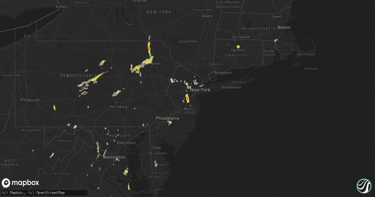
Hail Map on September 9, 2023
Get this storm
September 9 map
$229
one time, instant access
Download today. No call, no setup
Keep the $229
Bought the map and want the full workflow? Apply the entire $229 to a subscription within 7 days. None of it is wasted.
Every map, not just this one
This buys you this map. Subscription and you get every map we run, in the markets you choose from a few cities to whole states to nationwide. Plus real-time alerts the moment a storm fires.
Contact data
Name, contact info, occupancy, even credit band for addresses in the footprint. You go from where it hit to who to call.
Become the source they trust
Unlimited branding weather history reports on demand. You already have the documented answer ready for the property owner, and you are the one who showed up with it.
Property data and RoofTrace estimates
Pull up any address you have got, its value and the exact code rules for that jurisdiction, straight from One Click Code. Then RoofTrace estimates the squares, pitch, and roof value, priced the way you price.
States Impacted by Hail Map on September 9, 2023
Storm reports
District of Columbia
| Date | Description |
|---|---|
| 09/09/20231:45 PM CDT | About a dozen trees were blown down in the eastern area of washington dc... Including on 11th street southeast at alabama avenue southeast... In the 4200 block of brook |
New Mexico
| Date | Description |
|---|---|
| 09/08/20238:07 PM CDT | Awos station kcvs cannon air force base. |
| 09/08/20237:55 PM CDT | Asos station krow roswell air center. |
| 09/08/20237:50 PM CDT | Mesonet station prtn5 roosevelt swcd. |
| 09/08/20237:37 PM CDT | Mesonet station remn5 bitter lake wl refuge 14 nne |
| 09/08/20237:35 PM CDT | Corrects previous high sust winds report from 7 e tucumcari. Asos station ktcc tucumcari muni airport. |
| 09/08/20237:35 PM CDT | Asos station ktcc tucumcari muni airport. |
Oklahoma
| Date | Description |
|---|---|
| 09/09/20235:54 PM CDT | Report passed along by emergency manager with photos of hail. |
| 09/08/20237:07 PM CDT | A local report indicates 1.00 inch wind near 13 NNW Boise City |
New York
| Date | Description |
|---|---|
| 09/09/20235:34 PM CDT | Tree and wires down between wawarsing and napanoch. Time estimated from radar. |
| 09/09/20235:30 PM CDT | Single tree down near the shawagunk mountain area. Time estimated from radar |
Massachusetts
| Date | Description |
|---|---|
| 09/09/20235:02 PM CDT | Tree through a homes skylight on pond view way in the town of northborough. Relayed by amateur radio. |
| 09/09/20233:30 PM CDT | Large tree limb down on wires in the area of the 70 block of park street in the town of stoneham. |
| 09/09/20233:20 PM CDT | Relayed by amateur radio. Tree down on wires on jefferson street. |
| 09/09/20233:10 PM CDT | Tree down on the 200 block of plain street in the town of stoughton. Relayed by amateur radio. |
| 09/09/20233:09 PM CDT | Reports from melrose. Tree down on wires on country club road and a large branch on wires on orient place. Relayed by amateur radio. |
| 09/09/20232:44 PM CDT | Large tree and wires down at the intersection of bay road and summer street. Relayed my amateur radio. |
| 09/09/20232:35 PM CDT | Tree down on fisher street in the town of foxborough. Relayed by amateur radio. |
| 09/09/20232:35 PM CDT | Tree down on fisher street in the town of foxboroug |
| 09/09/20232:30 PM CDT | Tree down at the 100 block of high street in the town of plainville. Relayed by amateur radio. |
Virginia
| Date | Description |
|---|---|
| 09/09/20235:48 PM CDT | Trees down in pennington gap. |
| 09/09/20233:52 PM CDT | Tree down along carter stanley highway. |
| 09/09/20233:51 PM CDT | Tree down along buffalo creek road. |
| 09/09/20233:50 PM CDT | Multiple trees blew down around independent hill... Including one onto a house just west-northwest of town. |
| 09/09/20233:45 PM CDT | There were about a dozen calls for trees... Branches... And wires blown down around warrenton and central fauquier county. |
| 09/09/20233:40 PM CDT | Several trees and wires blew down around rixeyville. |
| 09/09/20233:30 PM CDT | Several trees and wires blew down around culpeper. |
| 09/09/20233:22 PM CDT | Report of tree down onto power lines... Some blocking the roadway along intersection of waterfall road and martinwood road. |
| 09/09/20233:22 PM CDT | Report of tree down onto powerlines near intersection of berkeley road and mountain road. |
| 09/09/20233:20 PM CDT | Several trees and wires blew down in southern culpeper county near stevensburg. |
| 09/09/20233:20 PM CDT | Several trees and wires blew down in northeastern stafford county. |
| 09/09/20233:15 PM CDT | Several trees and wires blew down near lucketts... Lovettsville... And waterford. |
| 09/09/20233:10 PM CDT | Several trees blew down across central orange county... Including one onto a car at house inn and bistro... And along va-617 everona road. |
| 09/09/20233:10 PM CDT | Several trees and wires blew down in southeastern stafford county. |
| 09/09/20233:04 PM CDT | At least a half dozen trees down near fredericksburg and surrounding areas to the south and west |
| 09/09/20233:03 PM CDT | A few trees and wires blew down in the city of fredericksburg... Including along caroline street and in the 1400 block of prince edward street. |
| 09/09/20233:00 PM CDT | Several trees and wires blew down between leesburg and purcellville. |
| 09/09/20232:45 PM CDT | Several trees and wires blew down in the arcola/aldie area. |
| 09/09/20232:30 PM CDT | Tree knocked down along us-360. Time estimated from radar. |
| 09/09/20232:24 PM CDT | A powerline was reported down on seacock chapel road. |
| 09/09/20232:18 PM CDT | Multiple trees blew down near and north of reston. |
| 09/09/20232:00 PM CDT | Trees were reported down near the holland bypass on highway 58. |
| 09/09/20231:44 PM CDT | Wires were reported down on little fork road. Time estimated from radar. |
| 09/09/202312:41 PM CDT | A tree fell down on the road near the intersection of redhouse road and courthouse highway. |
| 09/09/202312:35 PM CDT | The montgomery county 911 center reported that a large tree was blown down onto a vehicle in the 500 block of ellett road causing considerable damage to the vehicle. |
| 09/09/202312:34 PM CDT | The giles county 911 center reported that a tree was down at the intersection of houston lane and u.s. 460/virginia avenue in glen lyn. |
| 09/09/202312:30 PM CDT | The montgomery county 911 center reported that a tree was down near the intersection of south main street and professional park drive in blacksburg. |
| 09/09/202312:24 PM CDT | The montgomery county 911 center reports that a tree was down on angela road in the shawsville area. |
| 09/09/202312:23 PM CDT | Thunderstorm winds blew down one large tree limb near the intersection of grissom lane and park drive. |
| 09/09/202312:20 PM CDT | Thunderstorm winds blew down one tree along the 900 block of walton road. |
| 09/09/202311:57 AM CDT | Thunderstorm winds blew down one tree along nowlin lane close to where the road ends. |
| 09/09/202311:52 AM CDT | Thunderstorm winds blew down one tree near the intersection of ayers orchard road and clark house farm road. |
| 09/09/202311:29 AM CDT | Thunderstorm winds blew down one tree along the 800 block of hutson road. |
| 09/09/202310:53 AM CDT | Thunderstorm winds blew down one tree along the 1700 block of birch creek road. |
| 09/09/202312:45 AM CDT | Roof off of a marina with debris blown onto boats. Possible waterspout. Time estimated from radar. |
Pennsylvania
| Date | Description |
|---|---|
| 09/09/20235:35 PM CDT | Multiple reports of trees down in liberty township. Time estimated from radar. |
| 09/09/20235:26 PM CDT | Multiple reports of trees and wires down in falls township. Time estimated from radar. |
| 09/09/20235:26 PM CDT | Multiple reports of trees and wires down in overfield township. Time estimated from radar. |
| 09/09/20235:22 PM CDT | Multiple reports of trees down in franklin township. Time estimated from radar. |
| 09/09/20235:17 PM CDT | Multiple reports of trees down in bridgewater township. Time estimated from radar. |
| 09/09/20235:17 PM CDT | Trees down on summit street. Time estimated from radar. |
| 09/09/20235:10 PM CDT | Trees down time estimated from radar. |
| 09/09/20234:45 PM CDT | Tree down in road time estimated from radar. |
| 09/09/20234:40 PM CDT | Tree down on n abington road time estimated from radar. |
| 09/09/20234:24 PM CDT | Lycoming 911 reports trees and wires down across the 300 block of klump rd. |
| 09/09/20233:45 PM CDT | Trees down across jacksonville road blocking the roadway. Time estimated by radar. |
| 09/09/20233:38 PM CDT | Report from mping: quarter |
Texas
| Date | Description |
|---|---|
| 09/09/20235:15 PM CDT | 50 kt wind measured by the awos at comanche county-city airport. |
| 09/09/20234:52 PM CDT | Power poles down on circle drive in lake coleman. |
| 09/09/20234:52 PM CDT | Power poles down. |
| 09/09/20234:28 PM CDT | Public call reports hail ranging from peas to quarters. Time estimated by caller. |
| 09/08/202310:25 PM CDT | Measured by the west texas mesonet. |
| 09/08/20239:08 PM CDT | Bird... Tx raws site. |
Nebraska
| Date | Description |
|---|---|
| 09/09/20236:58 PM CDT | A local report indicates 59 MPH wind near 2 S Stockville |
| 09/09/20236:49 PM CDT | Measured on personal weather station. |
| 09/09/20236:30 PM CDT | A local report indicates 1.00 inch wind near Curtis |
| 09/09/20235:30 PM CDT | A local report indicates 1.00 inch wind near 10 S North Platte |
| 09/09/20234:00 PM CDT | A local report indicates 1.75 inch wind near 6 SE Callaway |
| 09/09/20233:57 PM CDT | Reports of vehicle damage in parking lot of business. Time estimated from radar. |
| 09/09/20233:40 PM CDT | Time estimated by radar. |
| 09/09/20233:22 PM CDT | Caller reports holes punched in outbuilding roof. Time estimated from radar. |
| 09/09/20233:15 PM CDT | A local report indicates 2.00 inch wind near 10 ENE Arnold |
| 09/08/20237:42 PM CDT | Asos station kmck mccook airport. |
| 09/08/20237:36 PM CDT | Mesonet station reports 61 mph gust at location. |
| 09/08/20237:02 PM CDT | A local report indicates 1.75 inch wind near 2 N Hayes Center |
Kansas
| Date | Description |
|---|---|
| 09/09/20236:42 PM CDT | Estimated golf ball sized hail reported at location via social media. |
| 09/09/20236:29 PM CDT | 2 inch diameter hail reported at location via social media. |
| 09/09/20236:28 PM CDT | Report received via social media of ping pong ball sized hail at location. |
| 09/09/20235:27 PM CDT | Quarter sized hail reported at location. |
| 09/09/20235:25 PM CDT | [landspout] report received via social media of a landspout tornado spotted 10 miles north and 10 miles west of saint francis... Ks. |
| 09/09/20231:59 AM CDT | Broadcast media relay of a measured wind gust report at main st. And santa fe st. In south garden city. |
| 09/09/202312:57 AM CDT | Kansas mesonet site at 10m. |
| 09/09/202312:57 AM CDT | Kansas meso |
| 09/08/202310:47 PM CDT | A local report indicates 70 MPH wind near 15 SE Gove |
| 09/08/202310:33 PM CDT | Mesonet station ovek1 gove 5se. |
| 09/08/202310:26 PM CDT | A local report indicates 58 MPH wind near 1 NW Quinter |
| 09/08/202310:20 PM CDT | Corrects previous tstm wnd gst report from 3 ese park. Mesonet station reported a 62 mph wind gust at location. |
| 09/08/202310:19 PM CDT | Mesonet station reported a 72 mph wind gust at location. |
| 09/08/202310:15 PM CDT | Kshp reported 3 semis rolling over due to strong winds between mm99 and mm104 on i-70. |
| 09/08/202310:01 PM CDT | A local report indicates 59 MPH wind near 7 N Grainfield |
| 09/08/202310:00 PM CDT | Mesonet station at location reported a 59 mph thunderstorm wind gust. |
| 09/08/20239:53 PM CDT | Mesonet site at location reported a 62 mph thunderstorm wind gust. |
| 09/08/20239:45 PM CDT | Report received via social media of half dollar sized hail at location. Possibly larger size as hail was not collected and measured immediately. |
| 09/08/20239:45 PM CDT | Corrects previous hail report from hoxie. Report received via social media of hail up to quarters in size at location. |
| 09/08/20239:24 PM CDT | A local report indicates 67 MPH wind near 5 S Selden |
Arizona
| Date | Description |
|---|---|
| 09/09/20234:30 PM CDT | [landspout] a landspout was reported near chino valley and was on the ground for one to two minutes. |
New Jersey
| Date | Description |
|---|---|
| 09/09/20234:18 PM CDT | Report of two trees down across walpack flatbrook road in walpack township. Pictures provided via social media. Time estimated via radar. |
| 09/09/20234:05 PM CDT | 911 call center reports wires down in blairstown. Time estimated via radar. |
| 09/09/20233:17 PM CDT | Quarter size hail in denville. Time estimated via radar. |
| 09/09/20233:08 PM CDT | 911 call center reports trees down all across the county. Time estimated via radar. |
| 09/09/20233:08 PM CDT | Jcpl reports tree damage resulting in 101-500 power outages in morristown. Time estimated from radar. |
| 09/09/20233:00 PM CDT | Tree down on valley road. |
| 09/09/20232:46 PM CDT | A local report indicates 1.00 inch wind near 1 N GLOUCESTER TWP |
| 09/09/20232:41 PM CDT | Downed power lines on summit ave... Time estimated by radar. |
| 09/09/20232:34 PM CDT | Tree down with wires on carnegie ave with time estimated by radar. |
| 09/09/20232:19 PM CDT | Report from mping: quarter |
| 09/09/20232:15 PM CDT | Hail up to the size of golf balls in new brunswick. Time estimated via radar. |
| 09/09/20232:10 PM CDT | A local report indicates 1.00 inch wind near New Brunswick |
| 09/09/20232:05 PM CDT | Hail of at least quarter size reported in north brunswick. |
| 09/09/20232:00 PM CDT | Corrects previous hail report from east brunswick. Quarter size hail in east brunswick. Time given in report. |
| 09/09/20231:50 PM CDT | A local report indicates 1.00 inch wind near Spotswood |
| 09/09/20231:09 PM CDT | 911 call center reports tree down into wires causing sparking. Time estimated via radar. |
Delaware
| Date | Description |
|---|---|
| 09/09/20233:47 PM CDT | Wir |
| 09/09/20233:47 PM CDT | Wires down resulting in power outages. Time estimated via radar. |
Maryland
| Date | Description |
|---|---|
| 09/09/20236:13 PM CDT | Several reports of trees/wires down north of north east at intersection of calvert rd and trinity church rd... And pine conde drive and bailiff rd. |
| 09/09/20235:59 PM CDT | Report of tree and wires down at intersection of old elk neck road and turkey point. Additional report of tree/wires down west of elkton at marley rd and polaski hwy in |
| 09/09/20235:35 PM CDT | 911 call center reports tree damage on the queen annes county side of chestertown. Time estimated via radar. |
| 09/09/20235:20 PM CDT | Two reports for trees and wires down in between hancock and pecktonville. |
| 09/09/20234:10 PM CDT | Wind gusts of up to 51 knots |
| 09/09/20233:45 PM CDT | A dozen reports of trees and wires causing traffic hazards near the hagerstown area. |
| 09/09/20233:45 PM CDT | There were calls for trees blown down in the marbury area. |
| 09/09/20233:44 PM CDT | Reports of several separate incidents of trees and wires down near emmitsburg. |
| 09/09/20233:33 PM CDT | Reports of several separate incidents of trees and wires down near brunswick in southwest frederick county md. |
| 09/09/20233:30 PM CDT | Reports of several separate incidents of trees and wires down near union bridge. |
| 09/09/20233:22 PM CDT | Reports of several separate incidents of trees and wires down near brunswick in southwest frederick county md. |
| 09/09/20233:15 PM CDT | Trees blew down on md-75 green valley road at repp road. |
| 09/09/20233:01 PM CDT | Numerous trees blew down near green valley and ijamsville. Trees blew down on md-75 green valley road at prcies distillery road... And on md-80 fingerboard road at ed m |
| 09/09/20232:56 PM CDT | Trees and wires blew down in damascus... Including near the intersection of md-27 ridge road and oak drive. |
| 09/09/20232:05 PM CDT | One tree and power lines down at rockville pike and jones bridge rd |
| 09/09/20231:46 PM CDT | Tree down onto a house |
| 09/09/20231:32 PM CDT | Several trees and wires blew down near the dc/maryland line in the suitland-silver hill area. |
Georgia
| Date | Description |
|---|---|
| 09/09/20232:41 PM CDT | Law enforcement reports multiple trees down across ga-136 east near villanow. |
| 09/08/20239:51 PM CDT | Tree down across power lines on shephard rd near payne ln. |
Wyoming
| Date | Description |
|---|---|
| 09/09/20231:06 AM CDT | Hail accumulating to several inches deep. |
| 09/09/20231:00 AM CDT | A local report indicates 1.00 inch wind near Yoder |
| 09/09/202312:46 AM CDT | Roads covered in hail accumulation. Largest hailstone was golf ball sized. |
| 09/08/202310:45 PM CDT | Emergency manager reported 2.8 inch hail relayed from dan fitts. |
| 09/08/202310:35 PM CDT | All large hail. Very little rainfall. |
| 09/08/202310:26 PM CDT | Golf ball hail at mile marker 34 on highway 26 between fort laramie and lingle. |
| 09/08/202310:25 PM CDT | Report from mping: half dollar |
| 09/08/202310:19 PM CDT | Spotter reported 2 inch hail ongoing. Started at 911pm. |
| 09/08/202310:00 PM CDT | Possible roof damage from hail around 9pm. |
| 09/08/202310:00 PM CDT | Golfball to baseball sized hail. |
| 09/08/20239:58 PM CDT | A local report indicates 1.75 inch wind near 4 N Fort Laramie |
| 09/08/20239:58 PM CDT | Report from mping: ping pong ball |
| 09/08/20238:30 PM CDT | Platte/converse county line wydot sensor and webcam. Hail covering interstate 25. Observation had zero visibility with heavy rain and wind gusts to 51 mph. |
South Dakota
| Date | Description |
|---|---|
| 09/08/202311:01 PM CDT | A local report indicates 62 MPH wind near 8 SSW Folsom |
North Carolina
| Date | Description |
|---|---|
| 09/09/20232:13 PM CDT | Utility company reported 141 customers without power in northampton county. |
| 09/09/20231:35 PM CDT | 911 call center reported trees and powerlines down along jr high school rd in scotland neck. Time estimated by radar. |
| 09/09/20231:29 PM CDT | Power outages were reported due to fallen trees on powerlines. Time estimated by radar. |
| 09/09/20231:26 PM CDT | Corrects previous tstm wnd dmg report from scotland neck. 911 call center reported trees and powerlines down along jr high school rd in scotland neck. Time estimated by |
| 09/09/202312:39 PM CDT | The stokes county 911 center reported that a tree was down in the sandy ridge area of stokes county. Time estimated by radar. |
| 09/09/202312:33 PM CDT | The stokes county 911 center reported that a tree was down in the pinnacle area. Time estimated by radar. |
| 09/09/202312:30 PM CDT | The stokes county 911 center reported that a tree was down in the king area. Time estimated by radar. |
| 09/09/202312:30 PM CDT | The stokes county 911 center reported that a tree was down in the danbury area. Time estimated by radar. |
| 09/09/202312:15 PM CDT | Thunderstorm winds blew down one tree along mile marker 86 of the northbound lanes on interstate 77. |
| 09/09/202311:57 AM CDT | One tree down on tody goodwin rd. |
| 09/09/202311:24 AM CDT | One tree down from thunderstorm winds. |
| 09/09/202311:00 AM CDT | The stokes county 911 center reported that a tree was down in the walnut cove area. Time estimated by radar. |
| 09/09/202310:56 AM CDT | Thunderstorm winds blew down one tree along the 5500 block of kerrs chapel road. |
| 09/09/202310:38 AM CDT | Utility company reports power outages due to fallen trees on power equipment on elbon dr and bowen blvd. |
| 09/09/202310:35 AM CDT | Tree down at rocky branch rd and poindexter st. |
| 09/09/20239:49 AM CDT | Thunderstorm winds blew down one tree near the intersection of smith loop and prospect church road. |
Connecticut
| Date | Description |
|---|---|
| 09/08/20239:09 PM CDT | Two power lines down in the road on old roberts street. |
Tennessee
| Date | Description |
|---|---|
| 09/09/20236:12 PM CDT | Trees down in the pinecrest community. |
| 09/08/20237:05 PM CDT | Few trees down near arthur. Time estimated from radar. |
West Virginia
| Date | Description |
|---|---|
| 09/09/20235:15 PM CDT | Several trees blew down near berkeley springs... Including in the 14000 block of cr-13 winchester grade road... In the 3100 block of cr-15 new hope road... And in the 2 |
| 09/09/20233:27 PM CDT | Tree down on dupont ave. |
| 09/09/20231:55 PM CDT | Numerous trees limbs and wires blew down along johnson run road. Hail accumulated in drifts. |
Cities Impacted by Hail Map on September 9, 2023
- Wood Lake, NE
- Johnstown, NE
- Ainsworth, NE
- Valentine, NE
- Saint Francis, SD
- Mission, SD
- Princeton, WV
- Glen Lyn, VA
- Narrows, VA
- Groesbeck, TX
- Thornton, TX
- Emporia, VA
- Montrose, WV
- Belington, WV
- Bassett, NE
- Newport, NE
- East Brunswick, NJ
- North Brunswick, NJ
- Milltown, NJ
- New Brunswick, NJ
- Somerset, NJ
- Arnold, NE
- Garfield, NJ
- Elmwood Park, NJ
- Saddle Brook, NJ
- Lodi, NJ
- Anselmo, NE
- Stapleton, NE
- Somerdale, NJ
- Blackwood, NJ
- Magnolia, NJ
- Voorhees, NJ
- Merna, NE
- Boswell, PA
- Laughlintown, PA
- Ligonier, PA
- Mount Tabor, NJ
- Morris Plains, NJ
- Denville, NJ
- Parsippany, NJ
- Bellefonte, PA
- Callaway, NE
- Howard, PA
- Blanchard, PA
- Beech Creek, PA
- Mill Hall, PA
- Broken Bow, NE
- Oconto, NE
- Sweet Valley, PA
- Benton, PA
- Hunlock Creek, PA
- Shickshinny, PA
- Lock Haven, PA
- De Leon, TX
- Comanche, TX
- Windsor, CT
- South Windsor, CT
- Coleman, TX
- Hop Bottom, PA
- Kingsley, PA
- Bay City, TX
- Palacios, TX
- Cozad, NE
- Lexington, NE
- Gothenburg, NE
- New Milford, PA
- Montrose, PA
- Clarks Summit, PA
- Dalton, PA
- Waverly, PA
- Factoryville, PA
- Tunkhannock, PA
- Falls, PA
- Pittston, PA
- North Platte, NE
- Maxwell, NE
- Olyphant, PA
- Jermyn, PA
- Hallstead, PA
- Wellfleet, NE
- Saint Francis, KS
- Talpa, TX
- Ballinger, TX
- Arapahoe, CO
- Cheyenne Wells, CO
- Brady, NE
- Moorefield, NE
- Curtis, NE
- Maywood, NE
- Andover, NJ
- Hackettstown, NJ
- Great Meadows, NJ
- Mechanicsville, MD
- Philipsburg, PA
- Hopatcong, NJ
- Stanhope, NJ
- Princeton, NJ
- Kendall Park, NJ
- Monmouth Junction, NJ
- Haymarket, VA
- Aldie, VA
- Petersburg, PA
- Morristown, NJ
- Mount Nebo, WV
- Nallen, WV
- Quinwood, WV
- Hico, WV
- Greenwood, DE
- Bridgeville, DE
- Hollywood, AL
- King William, VA
- Union Bridge, MD
- Woodsboro, MD
- McClure, VA
- Coeburn, VA
- Passaic, NJ
- Clifton, NJ
- Paterson, NJ
- Piscataway, NJ
- Monroe Township, NJ
- Highland Park, NJ
- Englishtown, NJ
- Newton, NJ
- Blairstown, NJ
- Mountain Lakes, NJ
- Linden, PA
- Tyrone, PA
- Warriors Mark, PA
- Pottersdale, PA
- Soddy Daisy, TN
- Sale Creek, TN
- Rock Creek, WV
- Dry Creek, WV
- Sandy Ridge, PA
- Osceola Mills, PA
- Prince Frederick, MD
- Port Republic, MD
- Luthersburg, PA
- Seaford, DE
- Cooksville, MD
- Sykesville, MD
- Woodbine, MD
- Leesburg, VA
- Paeonian Springs, VA
- Ruther Glen, VA
- Beaverdam, VA
- Spotsylvania, VA
- Waterford, VA
- Hamilton, VA
- Lovettsville, VA
- Florham Park, NJ
- Short Hills, NJ
- Chatham, NJ
- Madison, NJ
- Green Village, NJ
- Rockaway, NJ
- Whippany, NJ
- East Hanover, NJ
- Cedar Knolls, NJ
- Livingston, NJ
- Saint Charles, VA
- Pennington Gap, VA
- Stuart, NE
- Georgetown, DE
- Tellico Plains, TN
- Columbia, NJ
- Temple Hills, MD
- Suitland, MD
- Culpeper, VA
- Emmitsburg, MD
- Rocky Ridge, MD
- Thurmont, MD
- Hulett, WY
- Moorcroft, WY
- Totowa, NJ
- Little Falls, NJ
- Oak Hall, VA
- Scotland Neck, NC
- Clementon, NJ
- New Florence, PA
- Sterling, VA
- Runnemede, NJ
- Barrington, NJ
- Glendora, NJ
- Stratford, NJ
- Thermopolis, WY
- Scotland, MD
- Tall Timbers, MD
- Piney Point, MD
- Lottsburg, VA
- Kinsale, VA
- Mcminnville, TN
- Rock Island, TN
- Crozier, VA
- Upper Marlboro, MD
- Andrews Air Force Base, MD
- Maryville, TN
- Greenback, TN
- Atkinson, NE
- Clinton, TN
- Flintstone, MD
- Little Orleans, MD
- Artemas, PA
- Gloucester City, NJ
- Bellmawr, NJ
- Sewell, NJ
- Westville, NJ
- Woodbury, NJ
- Dublin, TX
- Warrenton, VA
- Milesburg, PA
- Dunning, NE
- Helmetta, NJ
- Edison, NJ
- Dunellen, NJ
- Middlesex, NJ
- Spotswood, NJ
- Accokeek, MD
- Randolph, NJ
- Wharton, NJ
- Dover, NJ
- Finksburg, MD
- Harrington, DE
- Huntingtown, MD
- Cumberland, RI
- Plainville, MA
- North Attleboro, MA
- Damascus, MD
- Clarksburg, MD
- Pennsylvania Furnace, PA
- Port Matilda, PA
- Herndon, VA
- Petersburg, WV
- Cammal, PA
- Smithwick, SD
- Hot Springs, SD
- Smithfield, VA
- Cabins, WV
- Upper Tract, WV
- Maysville, WV
- Oxon Hill, MD
- District Heights, MD
- Fort Washington, MD
- Weston, WY
- Custer, SD
- Julian, PA
- Fackler, AL
- La Follette, TN
- Jacksboro, TN
- Robbinsville, NJ
- Wrentham, MA
- Alexandria, PA
- Jenkins, KY
- Camden, NJ
- Pringle, SD
- Oral, SD
- Cliffside Park, NJ
- Fairview, NJ
- Edgewater, NJ
- North Bergen, NJ
- Cedar Run, PA
- Houston, DE
- Bethel, PA
- Bernville, PA
- Sopchoppy, FL
- Hillsborough, NJ
- Oakland, NJ
- Mahwah, NJ
- Great Falls, VA
- Reston, VA
- Bloomfield, CT
- Hartford, CT
- Ellendale, DE
- Spruce Creek, PA
- Aylett, VA
- Stillwater, PA
- Muncy Valley, PA
- Abingdon, VA
- Hampstead, MD
- Westminster, MD
- Manchester, MD
- Rapid City, SD
- Summerville, GA
- La Fayette, GA
- Trion, GA
- Gaithersburg, MD
- Germantown, MD
- Poolesville, MD
- Potomac, MD
- Ashburn, VA
- Vonore, TN
- Wallington, NJ
- Haledon, NJ
- Wyckoff, NJ
- Cedar Grove, NJ
- Wayne, NJ
- Montclair, NJ
- Ridgewood, NJ
- Hawthorne, NJ
- Melvin, TX
- Plainfield, NJ
- South Plainfield, NJ
- South Bound Brook, NJ
- Scottsboro, AL
- Woodville, AL
- Mohawk, TN
- Midway, TN
- Saint Leonard, MD
- Reisterstown, MD
- Strunk, KY
- Revelo, KY
- Stearns, KY
- Bronx, NY
- West New York, NJ
- New York, NY
- Jetersville, VA
- Warren, NJ
- Stirling, NJ
- Gillette, NJ
- Millington, NJ
- Keymar, MD
- Vaughn, NM
- Lititz, PA
- Stockville, NE
- Hayes Center, NE
- Wallace, NE
- Palisade, NE
- Culbertson, NE
- Bird City, KS
- Edson, KS
- Indianola, NE
- Bartley, NE
- Eustis, NE
- Trenton, NE
- McCook, NE
- Casper, WY
- Kaycee, WY
- Buffalo, WY
- Douglas, WY
- Herndon, KS
- Brewster, KS
- Colby, KS
- Boise City, OK
- Glendo, WY
- Oberlin, KS
- McDonald, KS
- Selden, KS
- Hartville, WY
- Jay Em, WY
- Felt, OK
- Quantico, VA
- Catlett, VA
- Fort Laramie, WY
- Hoxie, KS
- Atwood, KS
- Dalhart, TX
- Park, KS
- Quinter, KS
- Texline, TX
- Lingle, WY
- Torrington, WY
- Grainfield, KS
- Gove, KS
- Utica, KS
- Collyer, KS
- Rexford, KS
- Wheatland, WY
- Beeler, KS
- Dighton, KS
- Wallace, KS
- Sharon Springs, KS
- Guernsey, WY
- Yoder, WY
- Glenrock, WY
- Corona, NM
- Forsyth, GA
- Eldorado, TX
- Inez, TX
- Three Springs, PA
- Caryville, TN
- Spring City, TN
- Barkhamsted, CT
- Johnson City, TX
- Goldthwaite, TX
- Jersey Shore, PA
- Port Clinton, PA
- Shartlesville, PA
- Schuylkill Haven, PA
- Hamburg, PA
- Strausstown, PA
- Auburn, PA
- Mohrsville, PA
- Orwigsburg, PA
- May, TX
- Devils Tower, WY
- Round Mountain, TX
- Eastland, TX
- Ranger, TX
- Gorman, TX
- Dallas, PA
- Campo, CO
- Speedwell, TN
- Cumberland Gap, TN
- Ten Sleep, WY
- La Grange, TX
- Fayetteville, TX
- Liverpool, PA
- Wapwallopen, PA
- Glen Lyon, PA
- Bridger, MT
- Llano, TX
- Mullin, TX
- Lebanon, NE
- Eatonton, GA
- Sparta, GA
- Sandersville, GA
- Tennille, GA
- Clearville, PA
- Santa Rosa, NM
- Frederick, MD
- Middlesboro, KY
- Sunbury, PA
- Wilsonville, NE
- Norcatur, KS
- Andersonville, TN
- San Saba, TX
- Dalmatia, PA
- Harveys Lake, PA
- Rome, GA
- Nicholson, PA
- Newcastle, WY
- House, NM
- Danbury, NE
- Norton, KS
- Cambridge, NE
- Rockton, PA
- Priddy, TX
- Millerstown, PA
- Millersburg, PA
- Mount Pleasant Mills, PA
- Herndon, PA
- Port Trevorton, PA
- Victoria, TX
- Rochelle, TX
- Brady, TX
- Warfordsburg, PA
- Sidney, TX
- Shirleysburg, PA
- Sherwood, TN
- Sewanee, TN
- Rocky Top, TN
- Kenton, OK
- Voca, TX
- Perryville, MD
- Blessing, TX
- Noxen, PA
- South Pittsburg, TN
- Dornsife, PA
- Pine Knot, KY
- Duncannon, PA
- Commerce, GA
- Maysville, GA
- Homer, GA
- Lincoln University, PA
- West Grove, PA
- Oxford, PA
- Nottingham, PA
- Whitesburg, TN
- Cogan Station, PA
- Westminster, SC
- Berwick, PA
- Orangeville, PA
- Huntington Mills, PA
- Taylor, PA
- Shavertown, PA
- Scranton, PA
- Keokee, VA
- Sheppton, PA
- Ringtown, PA
- Hazleton, PA
- Binghamton, NY
- Kirkwood, NY
- Conklin, NY
- Windsor, NY
- East Bernard, TX
- Sundance, WY
- Pine Bush, NY
- Wallkill, NY
- Bedford, PA
- Veteran, WY
- Leoti, KS
- Deerfield, KS
- Lakin, KS
- Hawk Springs, WY
- Lyman, NE
- Crosbyton, TX
- Roaring Springs, TX
- Matador, TX
- Childress, TX
- Paducah, TX
- Bealeton, VA
- Healy, KS
- Scott City, KS
- Parkman, WY
- Dayton, WY
- Mount Airy, MD
- Vega, TX
- Broad Run, VA
- Fairfield, NJ
- Ijamsville, MD
- Monrovia, MD
- Levant, KS
- Catharpin, VA
- Gainesville, VA
- Berrysburg, PA
- Lykens, PA
- Elizabethville, PA
- Pillow, PA
- Middleburg, VA
- Purcellville, VA
- Lyons, NE
- Fairfax, VA
- Nescopeck, PA
- Monument, KS
- Oakley, KS
- The Plains, VA
- San Antonio, TX
- Wyoming, PA
- Schertz, TX
- Converse, TX
- Marion, TX
- Saint Hedwig, TX
- Callao, VA
- Shawnee, WY
- Hughesville, MD
- Waldorf, MD
- Post, TX
- Grinnell, KS
- New Church, VA
- Wyola, MT
- Midland, VA
- Old Forge, PA
- Altoona, PA
- Weskan, KS
- Rebuck, PA
- Cibolo, TX
- New Braunfels, TX
- Jbsa Randolph, TX
- Universal City, TX
- Clinton, MD
- Millville, PA
- New Windsor, MD
- Jefferson, MD
- Hollywood, MD
- Boyds, MD
- North East, MD
- Bulverde, TX
- Channing, TX
- Winona, KS
- Bolivar, PA
- Harrison, GA
- Aquasco, MD
- Chantilly, VA
- Rockville, MD
- Masterson, TX
- Laverne, OK
- Lubbock, TX
- Idalou, TX
- Mcadoo, TX
- Lorenzo, TX
- Marienthal, KS
- Manderson, WY
- Ralls, TX
- Crowell, TX
- Rising Sun, MD
- Elkton, MD
- Ferris, TX
- Carnesville, GA
- Slaton, TX
- Goree, TX
- Woodson, TX
- Shattuck, OK
- Gate, OK