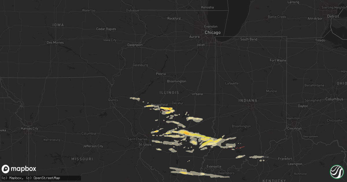
Hail Map in Illinois on August 6, 2023
Get this storm
August 6 map
$229
one time, instant access
Download today. No call, no setup
Keep the $229
Bought the map and want the full workflow? Apply the entire $229 to a subscription within 7 days. None of it is wasted.
Every map, not just this one
This buys you this map. Subscription and you get every map we run, in the markets you choose from a few cities to whole states to nationwide. Plus real-time alerts the moment a storm fires.
Contact data
Name, contact info, occupancy, even credit band for addresses in the footprint. You go from where it hit to who to call.
Become the source they trust
Unlimited branding weather history reports on demand. You already have the documented answer ready for the property owner, and you are the one who showed up with it.
Property data and RoofTrace estimates
Pull up any address you have got, its value and the exact code rules for that jurisdiction, straight from One Click Code. Then RoofTrace estimates the squares, pitch, and roof value, priced the way you price.
Storm reports in Illinois
Illinois
| Date | Description |
|---|---|
| 08/06/20236:50 PM CDT | A local report indicates 2.00 inch wind near 7 N Taylorville |
| 08/06/20236:46 PM CDT | Several homes and garages were damaged along 1600 east road. Numerous trees and power poles were snapped as well. |
| 08/06/20236:42 PM CDT | Time and location estimate. Report courtesy of ktvi. |
| 08/06/20236:33 PM CDT | A local report indicates 1.00 inch wind near 5 S Rochester |
| 08/06/20236:15 PM CDT | An outbuilding was damaged and a few trees were blown over near cardinal hill road and zion road. |
| 08/06/20236:13 PM CDT | Corrects previous tornado report from 2 nne pawnee. A farmstead was damaged near the intersection of cotton hill road and skaggs road. The roof was damaged and a few tr |
| 08/06/20236:13 PM CDT | A farmstead was damaged near the intersection of cotton hill road and galloway road. The roof was damaged and a few trees were uprooted. |
| 08/06/20236:11 PM CDT | Report from mping: quarter |
| 08/06/20236:10 PM CDT | Touched down 3 miles southwest of new city. |
| 08/06/20235:55 PM CDT | Power line down on e. Lake shore dr. Time estimated from radar. |
| 08/06/20231:00 AM CDT | Numerous reports of trees and power lines down in gallatin county. Nearly 900 custom |
| 08/06/20231:00 AM CDT | Numerous reports of trees and power lines down in gallatin county. Nearly 900 customers without power. |
| 08/06/202312:45 AM CDT | Tree fell through a residences roof on raleigh road. |
| 08/06/202312:41 AM CDT | Lots of trees down around town... Several trees and large limbs on houses. |
| 08/06/202312:40 AM CDT | Report from mping: trees uprooted or snapped; roof blown off. |
| 08/06/202312:33 AM CDT | Trees down around town. |
| 08/05/202311:09 PM CDT | Tree down on county highway 2. |
| 08/05/202311:04 PM CDT | A local report indicates 60 MPH wind near 2 W Fairfield |
| 08/05/202310:59 PM CDT | Lots of limbs down... And some power outages. |
| 08/05/202310:58 PM CDT | Corrected time. Tree down on county highway 2. Time estimated. |
| 08/05/20239:49 PM CDT | Report from mping: quarter |
| 08/05/20239:47 PM CDT | Report from mping: half dollar |
| 08/05/20238:58 PM CDT | Report from belleville awos. |
| 08/05/20238:36 PM CDT | Report from mping: 1-inch tree limbs broken; shingles blown off. |
| 08/05/20238:16 PM CDT | 50mph sustained with 60mph gusts. |
| 08/05/20238:10 PM CDT | Pictures of ping pong ball size hail submitted via social media. |
| 08/05/20238:09 PM CDT | A local report indicates 1.25 inch wind near Staunton |
| 08/05/20238:07 PM CDT | A local report indicates 1.00 inch wind near Staunton |
| 08/05/20238:07 PM CDT | Power pole down and on fire. |
| 08/05/20238:05 PM CDT | Significant roof damage to a house. |
| 08/05/20238:05 PM CDT | A tree was snapped. |
| 08/05/20238:00 PM CDT | Corrects previous tstm wnd gst report from 3 nw ingraham. 50mph sustained with 60mph gusts. |
| 08/05/20237:30 PM CDT | Several 2 to 4-inch diameter tree branches were blown down. |
| 08/05/20237:30 PM CDT | A local report indicates 60 MPH wind near Mason |
| 08/05/20237:26 PM CDT | A local report indicates 1.75 inch wind near Edgewood |
| 08/05/20237:20 PM CDT | A local report indicates 1.00 inch wind near Altamont |
| 08/05/20237:20 PM CDT | A local report indicates 1.00 inch wind near Altamont |
| 08/05/20237:08 PM CDT | Large trees and power lines were blown down. |
| 08/05/20237:02 PM CDT | Time estimate from radar. Photo via social media. |
| 08/05/20237:01 PM CDT | A local report indicates 1.25 inch wind near 1 E Taylorville |
| 08/05/20237:00 PM CDT | Report and photo of hail north and south of brownstown il. Location is approximate. Timing is estimate from radar. |
| 08/05/20237:00 PM CDT | A local report indicates 1.00 inch wind near 1 NW Taylorville |
All States Impacted by Hail Map on August 6, 2023
Cities Impacted by Hail Map on August 6, 2023
- Stratford, TX
- Dalhart, TX
- Dumas, TX
- Sunray, TX
- Cactus, TX
- Shelley, ID
- Idaho Falls, ID
- Iona, ID
- Blue Mountain, MS
- Oxford, MS
- Dacula, GA
- Bruce, MS
- Houlka, MS
- Vardaman, MS
- Lithonia, GA
- Woodland, MS
- Coffeeville, MS
- Paris, MS
- Water Valley, MS
- Banner, MS
- Lawrenceville, GA
- Houston, MS
- Decatur, GA
- Charleston, MS
- Oakland, MS
- Conyers, GA
- Loganville, GA
- Oxford, GA
- Tillatoba, MS
- Cascilla, MS
- Scobey, MS
- Bethlehem, GA
- Monroe, GA
- Winder, GA
- Summerville, GA
- La Fayette, GA
- Pontotoc, MS
- Randolph, MS
- Pittsboro, MS
- Covington, GA
- Auburn, GA
- Grayson, GA
- Suwanee, GA
- Ranburne, AL
- Town Creek, AL
- Leighton, AL
- Courtland, AL
- Moulton, AL
- Hillsboro, AL
- Danville, AL
- Trinity, AL
- Decatur, AL
- Tanner, AL
- Athens, AL
- Gastonia, NC
- McAdenville, NC
- Cramerton, NC
- Lowell, NC
- Mount Holly, NC
- Belmont, NC
- Charlotte, NC
- Huntersville, NC
- Hartselle, AL
- Madison, AL
- Somerville, AL
- Harvest, AL
- Huntsville, AL
- Valhermoso Springs, AL
- Brownsboro, AL
- New Market, AL
- Gurley, AL
- Owens Cross Roads, AL
- Trenton, AL
- Scottsboro, AL
- Woodville, AL
- Paint Rock, AL
- Hollytree, AL
- Estillfork, AL
- Princeton, AL
- Fackler, AL
- Hollywood, AL
- Stevenson, AL
- Littleton, CO
- Lone Tree, CO
- Englewood, CO
- Aurora, CO
- Parker, CO
- Alexander, IL
- New Berlin, IL
- Pleasant Plains, IL
- Rochester, IL
- Springfield, IL
- Edinburg, IL
- Taylorville, IL
- Tremonton, UT
- Stonington, IL
- Trinidad, CO
- Trinchera, CO
- Assumption, IL
- Nettleton, MS
- Amory, MS
- Red Bay, AL
- Vina, AL
- Golden, MS
- Hodges, AL
- Thermopolis, WY
- Eastaboga, AL
- Trussville, AL
- Pinson, AL
- Tishomingo, MS
- Belmont, MS
- Dennis, MS
- Jacksonville, AL
- Piedmont, AL
- Carrollton, GA
- Temple, GA
- Villa Rica, GA
- Powder Springs, GA
- Castle Rock, CO
- Newnan, GA
- Riverton, WY
- Franklin, GA
- Phil Campbell, AL
- Bowdon, GA
- Avondale Estates, GA
- Scottdale, GA
- Stone Mountain, GA
- Rainsville, AL
- Social Circle, GA
- Spruce Pine, AL
- Lagrange, GA
- Clayton, AL
- Crowheart, WY
- Ellenwood, GA
- Anniston, AL
- Russellville, AL
- Tuscumbia, AL
- Tupelo, MS
- Cedartown, GA
- Buchanan, GA
- Aragon, GA
- Rockmart, GA
- Heflin, AL
- Guntown, MS
- Saltillo, MS
- Bremen, GA
- Walden, CO
- Birmingham, AL
- Bessemer, AL
- Talladega, AL
- Hackleburg, AL
- Leesburg, AL
- Cedar Bluff, AL
- Collinsville, AL
- Thomasville, GA
- Eutaw, AL
- Knoxville, AL
- Carrollton, AL
- Jacksonville, IL
- Lincoln, AL
- Eva, AL
- Falkville, AL
- Hogansville, GA
- Atlanta, GA
- Roopville, GA
- Eclectic, AL
- Alexander City, AL
- Tallassee, AL
- Beardstown, IL
- Okolona, MS
- Aberdeen, MS
- Columbus, MS
- Punta Gorda, FL
- Northport, AL
- Baldwyn, MS
- Ashland, AL
- Plum Branch, SC
- Munford, AL
- Hamilton, MS
- Caledonia, MS
- Sulligent, AL
- Dubois, WY
- Tuscaloosa, AL
- Arab, AL
- Taylorsville, GA
- Warner Robins, GA
- Dry Branch, GA
- Belden, MS
- East Dublin, GA
- Kinnear, WY
- Mount Sterling, IL
- Frederick, IL
- Rushville, IL
- Daleville, AL
- Soperton, GA
- Carbon Hill, AL
- Berry, AL
- Tremont, MS
- Fulton, MS
- Mantachie, MS
- Cherokee, AL
- Shannon, MS
- Fayette, AL
- Aliceville, AL
- Gordo, AL
- Blue Springs, MS
- Attalla, AL
- Boaz, AL
- Fyffe, AL
- Crossville, AL
- Geraldine, AL
- Dawson, AL
- Sylacauga, AL
- Goodwater, AL
- Rockledge, GA
- Kennedy, AL
- Vernon, AL
- Smithville, MS
- Guntersville, AL
- Snellville, GA
- Grantville, GA
- Greenville, GA
- Pine Mountain, GA
- Ashland, IL
- Graham, AL
- Bryant, AL
- Trenton, GA
- New Albany, MS
- Millport, AL
- Winston, GA
- Douglasville, GA
- Marietta, GA
- Smyrna, GA
- Austell, GA
- Virginia, IL
- Macon, MS
- Ethelsville, AL
- Reform, AL
- Gadsden, AL
- Iva, SC
- Due West, SC
- Abbeville, SC
- Brookwood, AL
- Greenwood Springs, MS
- Boston, GA
- Newton, AL
- Cragford, AL
- Mansfield, GA
- Dallas, GA
- Crawford, MS
- Fort Payne, AL
- Delta, AL
- Jasper, AL
- Empire, AL
- Mount Hope, AL
- Kellyton, AL
- Hamilton, GA
- Colquitt, GA
- Damascus, GA
- Conley, GA
- Centre, AL
- Dutton, AL
- Pisgah, AL
- Buhl, AL
- Lineville, AL
- Chipley, FL
- Adrian, GA
- Whitesburg, GA
- Pell City, AL
- Cairo, GA
- Baileyton, AL
- Cullman, AL
- Niceville, FL
- Valparaiso, FL
- Prairie, MS
- Alpine, AL
- Roanoke, AL
- Woodland, AL
- Wedowee, AL
- Brooksville, MS
- Albertville, AL
- West Point, MS
- Gattman, MS
- Union Springs, AL
- Haddock, GA
- Macon, GA
- Gray, GA
- Milledgeville, GA
- Gordon, GA
- Wrightsville, GA
- Raton, NM
- Bellvue, CO
- Drake, CO
- Folsom, NM
- Pawnee, IL
- Mason, IL
- Edgewood, IL
- Dieterich, IL
- Des Moines, NM
- Grenville, NM
- Louisville, IL
- Newton, IL
- Franktown, CO
- Staunton, IL
- West Liberty, IL
- Clayton, NM
- Oblong, IL
- Sumner, IL
- Willow Hill, IL
- Claremont, IL
- Dundas, IL
- Bridgeport, IL
- Vincennes, IN
- Lawrenceville, IL
- Bruceville, IN
- Bicknell, IN
- Flat Rock, IL
- Edwardsport, IN
- Calhoun, IL
- Olney, IL
- Moweaqua, IL
- Saint Francisville, IL
- Rocky Ford, CO
- La Junta, CO
- Elbert, CO
- Larkspur, CO
- Colorado Springs, CO
- Peyton, CO
- Calhan, CO
- Dubois, IN
- French Lick, IN
- Paoli, IN
- Jasper, IN
- Camp Hill, AL
- Greenville, IL
- Beecher City, IL
- Cowden, IL
- Hereford, AZ
- Sandoval, IL
- Hurtsboro, AL
- Reed Point, MT
- Columbus, MT
- Peshastin, WA
- Patagonia, AZ
- Fort Washakie, WY
- Eufaula, AL
- Pittsview, AL
- Herrick, IL
- Plainville, IN
- Montgomery, IN
- Odon, IN
- Brownstown, IL
- Worden, IL
- Mount Olive, IL
- New Douglas, IL
- Walshville, IL
- Waggoner, IL
- Girard, IL
- Carlinville, IL
- Notasulga, AL
- Elizabeth, CO
- Vandalia, IL
- Red Feather Lakes, CO
- Shumway, IL
- Altamont, IL
- Chatham, IL
- Blue Mound, IL
- Breese, IL
- Aviston, IL
- Pana, IL
- Oconee, IL
- Tower Hill, IL
- Nokomis, IL
- Rosamond, IL
- Witt, IL
- Prattville, AL
- Carlyle, IL
- Shelbyville, IL
- Trilla, IL
- Mattoon, IL
- Neoga, IL
- Casey, IL
- Charleston, IL
- Lerna, IL
- Gays, IL
- Greenup, IL
- Toledo, IL
- Saint Peter, IL
- Windsor, IL
- Sullivan, IL
- Alma, IL
- Centralia, IL
- Strasburg, IL
- Westphalia, IN
- Sandborn, IN
- Sedalia, CO
- Mulberry Grove, IL
- Big Timber, MT
- Saint Elmo, IL
- Ingraham, IL
- Bulpitt, IL
- Glenarm, IL
- Kincaid, IL
- Loami, IL
- Tovey, IL
- Tuskegee, AL
- Marianna, FL
- Edwardsville, IL
- Hamel, IL
- Alhambra, IL
- Pocahontas, IL
- Odin, IL
- Salem, IL
- Kiowa, CO
- Parkersburg, IL
- Clay City, IL
- Owaneco, IL
- Iuka, IL
- Enterprise, AL
- New Baden, IL
- Woodlawn, IL
- Hoyleton, IL
- Richview, IL
- Irvington, IL
- West Salem, IL
- Shobonier, IL
- Smithboro, IL
- Ramsey, IL
- Weogufka, AL
- Ozark, AL
- Arabi, GA
- Melville, MT
- Sahuarita, AZ
- Tucson, AZ
- Vienna, GA
- Arapahoe, WY
- Lander, WY
- Sims, IL
- Morrisonville, IL
- Palmer, IL
- Harvel, IL
- Pitts, GA
- Tarrytown, GA
- Ailey, GA
- Mount Vernon, GA
- Sonoita, AZ
- Okawville, IL
- Jacksonville, GA
- Milan, GA
- Rhine, GA
- Auburn, AL
- Dadeville, AL
- Mascoutah, IL
- Highland, IL
- Kinmundy, IL
- Xenia, IL
- Glen Carbon, IL
- Troy, IL
- Saint Jacob, IL
- Collinsville, IL
- Skipperville, AL
- Ariton, AL
- Clio, AL
- Farina, IL
- Hardaway, AL
- Stewardson, IL
- Goshen, AL
- Watson, IL
- Wheeler, IL
- Ragsdale, IN
- Nogales, AZ
- Bunker Hill, IL
- Dorsey, IL
- Moro, IL
- Manzanola, CO
- Ashburn, GA
- Rebecca, GA
- Noble, IL
- Sailor Springs, IL
- Fillmore, IL
- Wheatland, IN
- Flora, IL
- Washington, IN
- Yoder, CO
- Alva, OK
- Cherokee, OK
- Dacoma, OK
- Carmen, OK
- Sapulpa, OK
- Sand Springs, OK
- Broken Arrow, OK
- Bixby, OK
- Haskell, OK
- Coweta, OK
- Porter, OK
- Beggs, OK
- Mounds, OK
- Okmulgee, OK
- Morris, OK
- Tulsa, OK
- Mooreland, OK
- Chester, OK
- Helena, OK
- Fairview, OK
- Owensboro, KY
- Hillsboro, IL
- Decker, IN
- Allendale, IL
- Mount Carmel, IL
- Eldorado, IL
- Harrisburg, IL
- Palmer Lake, CO
- Monument, CO
- Eckerty, IN
- Grantsburg, IN
- Taswell, IN
- Birdseye, IN
- English, IN
- Bristow, IN
- Kiefer, OK
- Karval, CO
- Sugar City, CO
- Carrier Mills, IL
- Thompsonville, IL
- Pittsburg, IL
- Galatia, IL
- Monroe City, IN
- Louisville, KY
- Geff, IL
- Keenes, IL
- Cisne, IL
- Fairfield, IL
- Lake George, CO
- Goltry, OK
- Jet, OK
- Eads, CO
- Royalton, IL
- Elkville, IL
- Mulkeytown, IL
- Westfield, IL
- Billings, OK
- Rush, CO
- Ordway, CO
- Litchfield, IL
- Van Buren, AR
- Muldrow, OK
- Arlington, CO
- Crane, IN
- Amado, AZ
- Albion, IL
- Bone Gap, IL
- Johnsonville, IL
- Haswell, CO
- Usaf Academy, CO
- Cannelburg, IN
- Loogootee, IN
- Checotah, OK
- Oktaha, OK
- Warner, OK
- Morganfield, KY
- Como, CO
- Effingham, IL
- Robards, KY
- Jefferson, CO
- Marion, IL
- Corydon, KY
- Waverly, KY
- Stilwell, OK
- Uniontown, AR
- Natural Dam, AR
- Lanesville, IN
- Corydon, IN
- Green Valley, AZ
- Sorento, IL
- Zeigler, IL
- Burlington, OK
- McLeansboro, IL
- Trenton, IL
- Kellyville, OK
- Bristow, OK
- Depew, OK
- Drumright, OK
- Cushing, OK
- Ridgway, IL
- Equality, IL
- Shawneetown, IL
- Junction, IL
- Arenzville, IL
- Fairdale, KY
- Uniontown, KY
- Ozark, AR
- Ralston, OK
- Garber, OK
- Quitman, GA
- Dixie, GA
- Johnston City, IL
- Sallisaw, OK
- Dix, IL
- Walnut Hill, IL
- Mount Vernon, IL
- Benton, IL
- Herrin, IL
- Energy, IL
- De Soto, IL
- Freeman Spur, IL
- West Frankfort, IL
- Carterville, IL
- Orient, IL
- Calhoun, KY
- Cambria, IL
- Du Quoin, IL
- Sebree, KY
- New Haven, IL
- Henderson, KY
- Saint Croix, IN
- Waverly, IL
- Honoraville, AL
- Highland Home, AL
- Patoka, IL
- Preston, GA
- Gillespie, IL
- Oaktown, IN
- Petersburg, IN
- Otwell, IN
- Shoals, IN
- Mount Judea, AR
- Witts Springs, AR
- Hector, AR
- Tilly, AR
- Leslie, AR
- Clinton, AR
- Dennard, AR
- Shirley, AR
- Prim, AR
- Edgemont, AR
- Drasco, AR
- Concord, AR
- Pettigrew, AR
- Elkins, AR
- Combs, AR
- Saint Paul, AR
- Witter, AR
- Marshall, AR
- Floral, AR
- Arnett, OK
- Vian, OK
- Fairfield Bay, AR
- Shattuck, OK
- Muskogee, OK
- Taft, OK
- Medford, OK
- Deer, AR
- Hamden, OH
- Jerusalem, AR
- Pelsor, AR
- Pomeroy, OH
- Albany, OH
- Bidwell, OH
- Cheshire, OH
- Langsville, OH
- Higden, AR
- Ida, AR
- Laverne, OK
- Follett, TX
- Balko, OK
- Newport, AR
- Oil Trough, AR
- Buffalo, OK
- Rosston, OK
- West Baden Springs, IN
- Boynton, OK
- Ulysses, KS
- Glenpool, OK
- Rudy, AR
- Beaver, OK
- New Albany, IN
- Kingston, AR
- Lamont, OK
- Jeffersonville, IN
- Georgetown, IN
- Clarksville, IN
- Turpin, OK
- Hugoton, KS
- Liberal, KS
- Oark, AR
- Huntsville, AR
- Bunch, OK
- Cedarville, AR
- Forgan, OK
- Tyrone, OK
- Jenks, OK
- Orleans, IN
- Waynoka, OK
- Gate, OK
- Booker, TX
- Darrouzett, TX
- Hooker, OK
- Nashville, TN
- Redbird, OK
- Frankfort, KY
- Wagoner, OK
- Ponca City, OK
- Fairfax, OK
- Marland, OK
- Mannford, OK
- Inola, OK
- Barling, AR
- Lavaca, AR
- Fargo, OK
- Pleasant Plains, AR
- Batesville, AR
- Rosie, AR
- Nebo, KY
- Madisonville, KY
- Smithville, WV
- Nash, OK
- Carrier, OK
- Saint Joe, AR
- Big Springs, WV
- Coldwater, KS
- Providence, KY
- Alma, AR
- Roland, OK
- Fort Smith, AR
- Arkoma, OK
- Locust Grove, AR
- Desha, AR
- Yale, OK
- Stroud, OK
- Terlton, OK
- Utica, KY
- Philpot, KY
- Williams, IN
- Gage, OK


