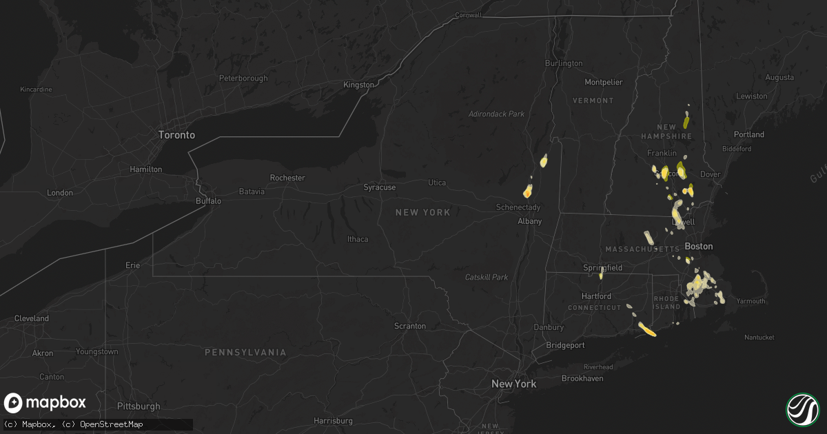
Hail Map in New York on August 15, 2024
Get this storm
August 15 map
$229
one time, instant access
Download today. No call, no setup
Keep the $229
Bought the map and want the full workflow? Apply the entire $229 to a subscription within 7 days. None of it is wasted.
Every map, not just this one
This buys you this map. Subscription and you get every map we run, in the markets you choose from a few cities to whole states to nationwide. Plus real-time alerts the moment a storm fires.
Contact data
Name, contact info, occupancy, even credit band for addresses in the footprint. You go from where it hit to who to call.
Become the source they trust
Unlimited branding weather history reports on demand. You already have the documented answer ready for the property owner, and you are the one who showed up with it.
Property data and RoofTrace estimates
Pull up any address you have got, its value and the exact code rules for that jurisdiction, straight from One Click Code. Then RoofTrace estimates the squares, pitch, and roof value, priced the way you price.
Storm reports in New York
New York
| Date | Description |
|---|---|
| 08/15/20245:06 PM CDT | Received report of trees down on power lines along burgoyne ave in hudson falls. Time based on radar. The period of the tstm wnd dmg event was 10 minutes. |
| 08/15/20245:06 PM CDT | Received report of trees down on power lines along burgoyne ave in hudson falls. Time based on radar. |
| 08/15/20245:05 PM CDT | Received report of trees and wires down along melony lane. Time based on radar. The period of the tstm wnd dmg event was 10 minutes. |
| 08/15/20245:05 PM CDT | Received report of trees and wires down along melony lane. Time based on radar. |
| 08/15/20244:59 PM CDT | Corrects previous tstm wnd dmg report from 1 ssw hudson falls. Tree down on lower main st in ft. Edward. |
| 08/15/20244:59 PM CDT | Tree down on lower main st in ft. Edward. |
| 08/15/20244:57 PM CDT | Tree down with road blocked on burgoyne ave/county route 41. |
| 08/15/20244:55 PM CDT | Delayed report received from broadcast media. Time estimated from radar. |
| 08/15/20244:55 PM CDT | Trees & wires down on east labarge st. |
| 08/15/20244:52 PM CDT | Tree and wires down on county route 41 in kingsbury. |
| 08/15/20244:49 PM CDT | Tree down blocking road on state route 4. |
| 08/15/20244:49 PM CDT | Corrects previous tstm wnd dmg report from 4 nne hudson falls. Tree down blocking road on state route 4. |
| 08/15/20244:45 PM CDT | Tree & wires down on hendee rd. |
| 08/15/20244:40 PM CDT | Received multiple reports of trees and wires down in the town of kingsbury. Time based on radar. |
| 08/15/20244:40 PM CDT | Received multiple reports of trees and wires down in the town of kingsbury. Time based on radar. The period of the tstm wnd dmg event was 30 minutes. |
| 08/15/20244:36 PM CDT | Received report of trees and wires down along state route 149 in the town of fort ann. Time based on radar. |
| 08/15/20244:36 PM CDT | Received report of trees and wires down along state route 149 in the town of fort ann. Time based on radar. The period of the tstm wnd dmg event was 10 minutes. |
| 08/15/20244:20 PM CDT | Tree and wires down on route 9 and dunning rd. |
| 08/15/20244:01 PM CDT | Tree down across east high st. |
| 08/15/20243:55 PM CDT | Near route 9 in malta. |
| 08/15/20243:55 PM CDT | Near route 9 in malta |
| 08/15/20243:53 PM CDT | Received a report of downed tree on house in the town of malta. |
| 08/15/20243:53 PM CDT | Received a report from media partner of estimated hail size of golf ball in the town of malta. Time is based on radar. The period of the hail event was 10 minutes. |
| 08/15/20243:53 PM CDT | Received a report of downed tree on house in the town of malta. The period of the tstm wnd dmg event was 30 minutes. |
| 08/15/20243:53 PM CDT | Received a report from media partner of estimated hail size of golf ball in the town of malta. Time is based on radar. |
| 08/15/20243:50 PM CDT | Social media report with video of ping pong ball sized hail falling in the town of malta. The period of the hail event was 10 minutes. |
| 08/15/20243:50 PM CDT | Social media report with video of ping pong ball sized hail falling in the town of malta. |
| 08/15/20243:42 PM CDT | Near raspbery dr. |
All States Impacted by Hail Map on August 15, 2024
Cities Impacted by Hail Map on August 15, 2024
- Crookston, NE
- Newport, NE
- Atkinson, NE
- Amelia, NE
- Emmet, NE
- Oneill, NE
- Chambers, NE
- Stuart, NE
- Inman, NE
- Chocorua, NH
- Ewing, NE
- Creighton, NE
- Neligh, NE
- Clearwater, NE
- Winnetoon, NE
- Royal, NE
- Orchard, NE
- Petersburg, NE
- Oakdale, NE
- Tilden, NE
- Loudon, NH
- Pittsfield, NH
- Chichester, NH
- Elgin, NE
- Brunswick, NE
- Wausa, NE
- Plainview, NE
- Osmond, NE
- Albion, NE
- Epsom, NH
- Meadow Grove, NE
- Deerfield, NH
- Newman Grove, NE
- Raymond, NH
- Chester, NH
- Concord, NH
- Suncook, NH
- Pierce, NE
- Contoocook, NH
- Fremont, NH
- Sandown, NH
- Warner, NH
- Winside, NE
- Hoskins, NE
- Cairo, NE
- Shelton, NE
- Bow, NH
- Stanton, NE
- Volin, SD
- Ravenna, NE
- Wood River, NE
- Wayne, NE
- Wakonda, SD
- Bedford, NH
- Manchester, NH
- Londonderry, NH
- Derry, NH
- Goffstown, NH
- Litchfield, NH
- Nashua, NH
- Hudson, NH
- Merrimack, NH
- Brookhaven, MS
- Windham, NH
- Pelham, NH
- Vaughan, MS
- Tamworth, NH
- Atkinson, NH
- Hampstead, NH
- McCall Creek, MS
- Lebanon, CT
- Auburn, NH
- Tyngsboro, MA
- Dunstable, MA
- Tylertown, MS
- Conway, NH
- Salem, NH
- Mccomb, MS
- Magnolia, MS
- Center Barnstead, NH
- Marion, MA
- North Franklin, CT
- North Chelmsford, MA
- Lowell, MA
- Dracut, MA
- Mattapoisett, MA
- Ayer, MA
- Harvard, MA
- Miami, FL
- Westford, MA
- Chelmsford, MA
- Mackay, ID
- Littleton, MA
- Halifax, MA
- Westminster, MA
- Jamestown, RI
- North Billerica, MA
- Columbia, MS
- Warren, RI
- Bristol, RI
- Norwich, CT
- Yantic, CT
- Wareham, MA
- Carver, MA
- West Wareham, MA
- East Wareham, MA
- Bogue Chitto, MS
- Onset, MA
- Buzzards Bay, MA
- Summit, MS
- Princeton, MA
- Jefferson, MA
- Sterling, MA
- Wakefield, RI
- Medfield, MA
- Walpole, MA
- Dover, MA
- Westwood, MA
- Norwood, MA
- West Boylston, MA
- Plympton, MA
- Ashland, MA
- Springfield, MA
- Meadville, MS
- Pocasset, MA
- Ledyard, CT
- East Walpole, MA
- Middleboro, MA
- West Springfield, MA
- Sherborn, MA
- Liberty, MS
- Saratoga Springs, NY
- Ballston Spa, NY
- Boylston, MA
- Shrewsbury, MA
- Mystic, CT
- Mashantucket, CT
- East Bridgewater, MA
- Dedham, MA
- Stonington, CT
- Pawcatuck, CT
- Westerly, RI
- East Hampton, NY
- Sag Harbor, NY
- Vermillion, SD
- Bridgewater, MA
- Holliston, MA
- Rochester, MA
- Raynham, MA
- South Easton, MA
- Kentwood, LA
- North Easton, MA
- Mechanicville, NY
- Stillwater, NY
- Norton, MA
- West Bridgewater, MA
- Page, NE
- Round Lake, NY
- Taunton, MA
- Lakeville, MA
- Gloster, MS
- East Taunton, MA
- Ballston Lake, NY
- Amite, LA
- Smithdale, MS
- Rehoboth, MA
- Franklinton, LA
- Berkley, MA
- North Dighton, MA
- Attleboro, MA
- Saint Mary, MO
- Perryville, MO
- Gansevoort, NY
- Butler, OK
- Dighton, MA
- Hammon, OK
- Fall River, MA
- Folsom, LA
- Assonet, MA
- Clifton Park, NY
- Summit, NY
- Delanson, NY
- Middleburgh, NY
- Schoharie, NY
- Delhi, NY
- Hamden, NY
- Rotterdam Junction, NY
- South Kortright, NY
- Bloomville, NY
- Burnt Hills, NY
- Fultonham, NY
- Warnerville, NY
- Schenectady, NY
- Jefferson, NY
- Pattersonville, NY
- Harpersfield, NY
- Walton, NY
- Richmondville, NY
- Stamford, NY
- Duanesburg, NY
- Laurens, NY
- Lockwood, NY
- Mount Vision, NY
- Lowman, NY
- Oxford, NY
- Bainbridge, NY
- Mount Upton, NY
- Binghamton, NY
- Garrattsville, NY
- Davenport Center, NY
- Howes Cave, NY
- Afton, NY
- Sharon Springs, NY
- Otego, NY
- Maryland, NY
- Greene, NY
- Guilford, NY
- Cherry Valley, NY
- Endicott, NY
- Amsterdam, NY
- Lisle, NY
- Deposit, NY
- Wells Bridge, NY
- Portlandville, NY
- Hartwick, NY
- West Davenport, NY
- Whitney Point, NY
- Unadilla, NY
- Sprakers, NY
- East Meredith, NY
- West Oneonta, NY
- Sidney Center, NY
- Westford, NY
- Roseboom, NY
- Barton, NY
- Chenango Forks, NY
- Elmira, NY
- Fultonville, NY
- Norwich, NY
- Cooperstown, NY
- Sidney, NY
- Smithville Flats, NY
- Waverly, NY
- Charlotteville, NY
- Hobart, NY
- Glen Aubrey, NY
- Newark Valley, NY
- Spencer, NY
- Harpursville, NY
- Meridale, NY
- Masonville, NY
- Milford, NY
- Maine, NY
- Johnson City, NY
- McDonough, NY
- Horseheads, NY
- East Worcester, NY
- New Lisbon, NY
- Central Bridge, NY
- Candor, NY
- Gilbertsville, NY
- Sloansville, NY
- Van Etten, NY
- West Fulton, NY
- Erin, NY
- Treadwell, NY
- Esperance, NY
- Berkshire, NY
- Owego, NY
- Davenport, NY
- Worcester, NY
- Castle Creek, NY
- Willseyville, NY
- Cobleskill, NY
- Schenevus, NY
- Morris, NY
- Port Crane, NY
- Nineveh, NY
- Oneonta, NY
- South New Berlin, NY
- Carlisle, NY
- New Berlin, NY
- Franklin, NY
- Keuka Park, NY
- King Ferry, NY
- Prattsburgh, NY
- Jordanville, NY
- West Winfield, NY
- Hunt, NY
- Franklinville, NY
- Penn Yan, NY
- Springfield Center, NY
- Mayville, NY
- Brookfield, NY
- Farmersville Station, NY
- Truxton, NY
- Branchport, NY
- Fillmore, NY
- Georgetown, NY
- Palatine Bridge, NY
- Cohocton, NY
- Preble, NY
- Wayland, NY
- Ellicottville, NY
- Canajoharie, NY
- Interlaken, NY
- Cherry Creek, NY
- Hubbardsville, NY
- Tully, NY
- Sinclairville, NY
- Moravia, NY
- Machias, NY
- West Valley, NY
- Galway, NY
- Genoa, NY
- Himrod, NY
- Hamilton, NY
- Lodi, NY
- Locke, NY
- North Brookfield, NY
- Canaseraga, NY
- Little Valley, NY
- Houghton, NY
- Arkport, NY
- Earlville, NY
- Fort Plain, NY
- Waterville, NY
- Conewango Valley, NY
- De Ruyter, NY
- Richfield Springs, NY
- Cattaraugus, NY
- Dansville, NY
- Cortland, NY
- Homer, NY
- Fonda, NY
- Fort Hunter, NY
- West Edmeston, NY
- Leonardsville, NY
- Swain, NY
- Dalton, NY
- East Otto, NY
- Daniel, WY
- Rockwood, IL
- Fort Ann, NY
- Hudson Falls, NY
- Denham Springs, LA
- Walker, LA
- Gilmanton Iron Works, NH
- Alton, NH
- Greenwell Springs, LA
- Suffield, CT
- Swansea, MA
- Agawam, MA
- Longmeadow, MA
- Covington, LA
- Tiverton, RI
- Enfield, CT
- Barrington, RI
- Malta, ID
- Somerset, MA
- Glens Falls, NY
- Greenfield Center, NY
- South Glens Falls, NY
- Queensbury, NY
- Fort Edward, NY
- Rockland, ID
- Hopkinton, MA
- Jacob, IL
- Frohna, MO
- Brockton, MA
- Amazonia, MO
- Saint Joseph, MO
- Savannah, MO
- Cosby, MO
- Weare, NH
- Wallowa, OR
- Dunbarton, NH
- Newellton, LA
- Saint Joseph, LA
- Modoc, IL
- Calumet, OK
- Saint Francisville, LA
- Livingston, LA
- Ellis Grove, IL
- Apache, OK
- Holden, LA
- Gorham, IL
- Cheyenne, OK
- Medford, OK
- Sparta, IL
- Helena, MO
- Clarksdale, MO
- Union Star, MO
- Amity, MO
- Jackson, LA
- Boxborough, MA
- Baton Rouge, LA
- Grand Tower, IL
- Cutler, IL
- Donaldsonville, LA
- Walsh, IL
- Billerica, MA
- Carlisle, MA
- Devens, MA
- Percy, IL
- Prairieville, LA
- Gonzales, LA
- French Settlement, LA
- Saint Amant, LA
- Quitaque, TX
- Altenburg, MO
- Port Gibson, MS
- Narragansett, RI
- Stewartsville, MO
- Maysville, MO
- El Reno, OK
- Hydro, OK
- Bush, LA
- King City, MO
- Darlington, MO
- Abita Springs, LA
- Pomona, IL
- Chester, IL
- Ames, OK
- Meno, OK
- Drummond, OK
- Geismar, LA
- Belle Rose, LA
- Sorrento, LA
- Darrow, LA
- Braman, OK
- Union City, OK
- Osborn, MO
- Saint Gabriel, LA
- Lorman, MS
- Steeleville, IL
- Lahoma, OK
- Cameron, MO
- Weatherby, MO
- Alto Pass, IL
- Saint James, LA
- Coulterville, IL
- Nashville, IL
- Addieville, IL
- Kellogg, IA
- Newton, IA
- Moore, ID
- Grinnell, IA
- Convent, LA
- Sunshine, LA
- Plattenville, LA
- Leland, MS
- Elgin, OK
- Oakdale, IL
- South Haven, KS
- Geuda Springs, KS
- Catoosa, OK
- Enid, OK
- Woonsocket, SD
- Malcom, IA
- Farrar, MO
- Wolf Lake, IL
- McFall, MO
- Albany, MO
- Napoleonville, LA
- Carville, LA
- Terreton, ID
- Cobden, IL
- Anna, IL
- Owasso, OK
- Claremore, OK
- Waukomis, OK
- De Smet, SD
- Newkirk, OK
- Minco, OK
- Candia, NH
- Bethany, MO
- New Hampton, MO
- Montezuma, IA
- Turkey, TX
- Lookeba, OK
- Gallatin, MO
- Kidder, MO
- Hamilton, MO
- Winston, MO
- Weatherford, OK
- Hinton, OK
- Binger, OK
- Arkansas City, KS
- Tuttle, OK
- Pocasset, OK
- Buffalo, MO
- Amber, OK
- Carnegie, OK
- Fort Cobb, OK
- Flomot, TX
- Campbell Hill, IL
- Corn, OK
- Centralia, IL
- Inola, OK
- Westport, MA
- Stoughton, MA
- Sandoval, IL
- Brooklyn, IA
- Kress, TX
- Hanson, MA
- Matador, TX
- Chickasha, OK
- Duncan, OK
- Comanche, OK
- Cordell, OK
- Letcher, SD
- Elkland, MO
- Chouteau, OK
- Long Lane, MO
- Duson, LA
- Lafayette, LA
- Scott, LA
- Odin, IL
- Tulsa, OK
- Hunter, OK
- Billings, OK
- Mountain View, OK
- Anadarko, OK
- Hollis, OK
- Camdenton, MO
- Lebanon, MO
- Alex, OK
- Deep River, IA
- Red Bud, IL
- Evansville, IL
- Blanchard, OK
- Gracemont, OK
- Florence, MT
- Garber, OK
- Jonesboro, IL
- Jackson, MO
- Mangum, OK
- Prairie Du Rocher, IL
- Montreal, MO
- Diagonal, IA
- Mount Ayr, IA
- Carpenter, SD
- Stoutland, MO
- Wagoner, OK
- Coyle, OK
- Gould, OK
- Quapaw, OK
- Raton, NM
- Eldridge, MO
- Moulton, IA
- Bloomfield, IA
- Ellston, IA
- Tingley, IA
- Granite, OK
- Lone Wolf, OK
- Perry, OK
- Dongola, IL
- Webster, IA
- Keswick, IA
- Mount Vernon, MO
- Aurora, MO
- Altus, OK
- Birmingham, IA
- Douds, IA
- Hobart, OK
- Drakesville, IA
- Buncombe, IL
- Tunas, MO
- Vienna, IL
- Iroquois, SD
- Quanah, TX
- Ullin, IL
- Cypress, IL
- Pulaski, IL
- Craigmont, ID
- Stillwater, OK
- Conway, MO
- Selma, IA
- Stockport, IA
- Fairfield, IA
- Marionville, MO
- Perkins, OK
- Marshfield, MO
- Sigourney, IA
- Karnak, IL
- Belknap, IL
- Republic, MO
- Ash Grove, MO
- Billings, MO
- Orlando, OK
- Guthrie, OK
- Crescent, OK
- Andrews, TX
- Grand Chain, IL
- Olmsted, IL
- Wapello, IA
- Morning Sun, IA
- Columbus Junction, IA
- Coweta, OK
- Broken Arrow, OK
- Lockridge, IA
- Mount Pleasant, IA
- Winfield, IA
- Mulhall, OK
- Kevil, KY
- Tamms, IL
- Villa Ridge, IL
- La Center, KY
- Niangua, MO
- Salem, IA
- Hillsboro, IA
- Ozark, MO
- Rogersville, MO
- Springfield, MO
- Mounds, IL
- Brookline, MO
- Eldon, IA
- Ottumwa, IA
- Floris, IA
- Eunice, NM
- Vienna, MO
- Ripley, OK
- Batavia, IA
- Libertyville, IA
- Mount Union, IA
- New London, IA
- Belle, MO
- Strafford, MO
- Wellston, OK
- Meridian, OK
- Columbia, IL
- Millstadt, IL
- Fair Grove, MO
- Danville, IA
- Ollie, IA
- Mountain Grove, MO
- Falcon, MO
- Hartville, MO
- Sand Springs, OK
- Harper, IA
- Yale, OK
- Keithsburg, IL
- New Boston, IL
- Oakville, IA
- Carney, OK
- Plato, MO
- Lynchburg, MO
- Elmer, OK
- Bland, MO
- Grovespring, MO
- Dixon, MO
- Iberia, MO
- Maramec, OK
- Pawnee, OK
- Chandler, OK
- Freeburg, IL
- Smithton, IL
- Belleville, IL
- Cushing, OK
- Fort Leonard Wood, MO
- West Burlington, IA
- Middletown, IA
- Pulaski, IA
- Milton, IA
- Licking, MO
- Roby, MO
- Phillipsburg, MO
- Waynesville, MO
- Glencoe, OK
- Cairo, IL
- Barlow, KY
- Burlington, IA
- West Point, IA
- Richland, IA
- Drumright, OK
- Jennings, OK
- Brinktown, MO
- Mannford, OK
- Oquawka, IL
- Cleveland, OK
- Readstown, WI
- Stroud, OK
- Bolivar, MO
- Half Way, MO
- Fairmont, OK
- Terlton, OK
- Clarendon, TX
- West Ossipee, NH
- Center Ossipee, NH
- South Tamworth, NH
- Moultonborough, NH
- Keosauqua, IA
- Prue, OK
- Osage, OK
- Mount Sterling, IA
- Bonaparte, IA
- Gladstone, IL
- Douglas, OK
- West Liberty, IA
- Carman, IL
- Viola, WI
- Viroqua, WI
- Stronghurst, IL
- Sperry, IA
- Pacific, MO
- Eureka, MO
- Canterbury, NH
- Nottingham, NH
- Alexis, IL
- Kirkwood, IL
- Monmouth, IL
- Graff, MO
- Meta, MO
- Farmington, IA
- Washington, MO
- Media, IL
- Atalissa, IA
- Valley Park, MO
- Ballwin, MO
- Biggsville, IL
- Marthasville, MO
- New Haven, MO
- Cantril, IA
- Seymour, MO
- Vichy, MO
- Wellington, TX
- Aledo, IL
- Saint Louis, MO
- Roseville, IL
- Smithshire, IL
- Bristow, OK
- Depew, OK
- North Henderson, IL
- Sapulpa, OK
- Kellyville, OK
- House Springs, MO
- High Ridge, MO
- Chesterfield, MO
- Gerlaw, IL
- Mansfield, MO
- Cameron, IL
- Galesburg, IL
- Wildwood, MO
- Defiance, MO
- Arbela, MO
- Luray, MO
- Augusta, MO
- Foristell, MO
- Wentzville, MO
- Kahoka, MO
- Wataga, IL
- Henderson, IL
- Oneida, IL
- Okemah, OK
- West Plains, MO
- Willow Springs, MO
- Pomona, MO
- Sperry, OK
- Knoxville, IL
- Gilson, IL
- Dahinda, IL
- Beggs, OK
- Laquey, MO
- O'Fallon, MO
- Huggins, MO
- Abingdon, IL
- Lake Saint Louis, MO
- Gotebo, OK
- Saint Peters, MO
- Mounds, OK
- Castle, OK
- Ava, MO
- Donnellson, IA
- Argyle, IA
- Raritan, IL
- Berwick, IL
- Okmulgee, OK
- South English, IA
- Guernsey, IA
- Victor, IA
- Glenpool, OK
- Bixby, OK
- Jenks, OK
- Owensville, MO
- Maquon, IL
- Williamsfield, IL
- Cabool, MO
- Sullivan, MO
- Saint Clair, MO
- Yates City, IL
- Victoria, IL
- Gerald, MO
- What Cheer, IA
- Keota, IA
- Fordland, MO
- Montrose, IA
- Laura, IL
- Keokuk, IA
- Wayland, MO
- Waterloo, IL
- Alexandria, MO
- Warsaw, IL
- Morris, OK
- Henryetta, OK
- Haskell, OK
- Dallas City, IL
- Carthage, IL
- Norwood, MO
- Peace Valley, MO
- Roosevelt, OK
- Sorento, IL
- Walshville, IL
- Macon, MO
- Bevier, MO
- Porter, OK
- Marissa, IL
- Tilden, IL
- Weleetka, OK
- Wetumka, OK
- Richland, MO
- Bushnell, IL
- Macomb, IL
- Kiefer, OK
- Mendon, IL
- Loraine, IL
- Saint Augustine, IL
- Alton, MO
- Colchester, IL
- Marietta, IL
- Durham, MO
- Bardolph, IL
- Bethel, MO
- Newark, MO
- Shelbyville, MO
- Elmwood, IL
- Leonard, MO
- Couch, MO
- Industry, IL
- Doniphan, MO
- Fenton, MO
- La Belle, MO
- Ewing, MO
- Novelty, MO
- Grandin, MO
- Shelbina, MO
- Des Moines, NM
- Vermont, IL
- Adair, IL
- Table Grove, IL
- Emden, MO
- Lewistown, MO
- Ramsey, IL
- Bonnie, IL
- Mount Vernon, IL
- Willow Lake, SD
- Canton, IL
- Saint David, IL
- Hunnewell, MO
- Monticello, MO
- Astoria, IL
- Ipava, IL
- Belle Rive, IL
- Opdyke, IL
- Poplar Bluff, MO
- Lewistown, IL
- Bryant, IL
- Lostant, IL
- Tonica, IL
- Maywood, MO
- Monroe City, MO
- Canton, MO
- Havana, IL
- Bunker Hill, IL
- Dahlgren, IL
- Harviell, MO
- Fairdealing, MO
- Checotah, OK
- Oakford, IL
- Sugar Grove, IL
- Aurora, IL
- Montgomery, IL
- Bristol, IL
- Granite City, IL
- Beardstown, IL
- Virginia, IL
- Mount Sterling, IL
- Cassville, MO
- Bellflower, IL
- Fisher, IL
- Hickory Hills, IL
- Palos Hills, IL
- Summit Argo, IL
- Chicago, IL
- Bridgeview, IL
- Justice, IL
- Atlanta, IL
- Burbank, IL
- Oak Lawn, IL
- Foosland, IL
- Dewey, IL
- Cape Fair, MO
- Galena, MO
- Eufaula, OK
- McLean, IL
- Reeds Spring, MO
- Rankin, IL
- Branson, MO
- Rockaway Beach, MO
- Walnut Shade, MO
- Mount Pulaski, IL
- Lawndale, IL
- Lincoln, IL
- Clinton, IL
- Kenney, IL
- Maroa, IL
- Ludlow, IL
- Gifford, IL
- Seymour, IL
- Hoopeston, IL
- Fithian, IL
- Oakwood, IL
- Danville, IL
- Farmersville, IL
- Harvel, IL
- Morrisonville, IL
- Milford, IL
- Bernie, MO
- Palmer, IL
- Parma, MO
- Malden, MO
- Taylorville, IL
- Crawfordsville, IN
- Bedford, IN
- Bourbon, MO
- Birch Tree, MO
- Toulon, IL


