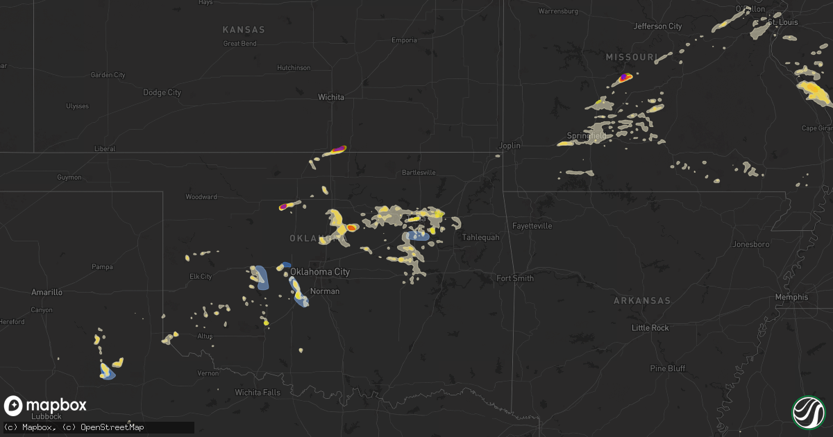
Hail Map on August 15, 2024
Get this storm
August 15 map
$229
one time, instant access
Download today. No call, no setup
Keep the $229
Bought the map and want the full workflow? Apply the entire $229 to a subscription within 7 days. None of it is wasted.
Every map, not just this one
This buys you this map. Subscription and you get every map we run, in the markets you choose from a few cities to whole states to nationwide. Plus real-time alerts the moment a storm fires.
Contact data
Name, contact info, occupancy, even credit band for addresses in the footprint. You go from where it hit to who to call.
Become the source they trust
Unlimited branding weather history reports on demand. You already have the documented answer ready for the property owner, and you are the one who showed up with it.
Property data and RoofTrace estimates
Pull up any address you have got, its value and the exact code rules for that jurisdiction, straight from One Click Code. Then RoofTrace estimates the squares, pitch, and roof value, priced the way you price.
States Impacted by Hail Map on August 15, 2024
Storm reports
Idaho
| Date | Description |
|---|---|
| 08/15/20246:44 PM CDT | Private weather station along e lincoln rd near wood river rd. |
| 08/15/20246:36 PM CDT | Time corrected. 2600 idaho falls power customers without power due to downed power line. Time estimated based on radar. |
| 08/15/20246:30 PM CDT | Large tree blown over onto road. Time approximated via nearby wind gust reports and radar. Image from media partner via twitter. |
| 08/15/20246:30 PM CDT | Tree down across sunnyside road in ammon per local news 8 and was blocking traffic. |
| 08/15/20246:10 PM CDT | Rocky mountain power reports a power outage in the area due to thunderstorm winds. |
| 08/15/20245:56 PM CDT | 3 large trees reported down at jensen grove park. Time estimated based on radar. |
| 08/15/20245:51 PM CDT | Several reports of localized tree damage in blackfoot. Tree on fire in the area of collins st with a limb down on wires. Time estimated based on radar. |
| 08/15/20245:45 PM CDT | Top half of a large tree snapped off in the gibson area. Time estimated based on radar and nearby observed wind gusts. Report and photo via social media. |
| 08/15/20245:27 PM CDT | Idaho power reports over 2...000 customers without power in the area. |
| 08/15/20245:25 PM CDT | Asos station kpih pocatello regional airport. |
| 08/15/20245:15 PM CDT | Mesonet station fw4083 2 nw pocatello. |
| 08/14/20247:58 PM CDT | 2600 idaho falls power customers without power due to downed power line. Time estimated based on radar. |
| 08/14/20247:15 PM CDT | Antelope flats rwis site. |
Rhode Island
| Date | Description |
|---|---|
| 08/15/20243:54 PM CDT | Reported by trained spotter. |
| 08/15/20243:50 PM CDT | In westerly... Half-dollar sized hail reported. Relayed via amateur radio. |
| 08/15/20243:47 PM CDT | A local report indicates 1.25 inch wind near 1 W Westerly AP |
| 08/15/20243:47 PM CDT | Spotter called reporting 1 hail just outside westerly. |
| 08/15/20243:45 PM CDT | Spotter reported 1.5 inch hail on yarmouth dr. In westerly... Ri. Time estimated via radar. Relayed via amateur radio. |
Missouri
| Date | Description |
|---|---|
| 08/15/20246:37 PM CDT | A local report indicates 1.00 inch wind near 1 ESE Buffalo |
| 08/15/20246:25 PM CDT | 2 to 3 inch tree limbs were also downed with the storm along with the hail. |
| 08/15/20246:25 PM CDT | Delayed report of tree limbs down... Siding damage... And a wooden play set tipped over. Time estimated from radar. |
| 08/15/20245:51 PM CDT | Video of chaser being hit by hail. Time and location estimated by radar. |
| 08/14/202411:20 PM CDT | Delayed report of several trees down across county roads in the junction hill area east of west plains. |
| 08/14/202411:15 PM CDT | Delayed report of trees and powerlines down in west plains as well as zz highway east of west plains. |
| 08/14/202410:54 PM CDT | Corrects previous tstm wnd dmg report from dora. Minor roof damage to a barn was reported. Several large limbs were also reported down. |
| 08/14/20249:54 PM CDT | Minor roof damage to a barn was reported. Several large limbs were also reported down. |
| 08/14/20249:52 PM CDT | Delayed report... Time estimated from radar. Public report of large trees down blocking old springfield road. |
| 08/14/20249:03 PM CDT | Delayed report of multiple trees down and a barn roof torn off on lon road north of rogersville. |
| 08/14/20249:00 PM CDT | Several large trees were blown over. Trees were blown onto cars a three different homes. |
| 08/14/20248:35 PM CDT | 12 to 14 inch tree downed. |
| 08/14/20248:23 PM CDT | Multiple reports of 60 mph winds were reported in the republic... Mo area. |
| 08/14/20248:22 PM CDT | Tree downed. |
| 08/14/20247:48 PM CDT | Measured 65 mph winds in iberia. |
| 08/14/20247:10 PM CDT | Picture with ruler of a hail stone which was 3.25 inches long and 1.5 inches wide. |
| 08/14/20247:02 PM CDT | A local report indicates 1.75 inch wind near Decaturville |
Massachusetts
| Date | Description |
|---|---|
| 08/15/20244:00 PM CDT | Picture of quarter sized hail on twitter based out of raynham. Time estimated via radar. |
| 08/15/20243:55 PM CDT | In bridgewater... Small tree reported down on vernon st. Time estimated by radar. |
| 08/15/20243:54 PM CDT | Emergency manager posted image on twitter describing quarter sized hail that melted rather quickly. Posted from raynham. |
| 08/15/20243:22 PM CDT | In wellesley... Police tweeted picture of a tree down on beverly rd. |
| 08/15/20243:19 PM CDT | In springfield... A tree fell down on a car on dwight st. Person inside was freed and is ok according to fire dept. Relayed via amateur radio. |
| 08/15/20243:15 PM CDT | A local report indicates 1.00 inch wind near Norwood |
| 08/15/20243:09 PM CDT | A local report indicates 1.00 inch wind near 3 N Walpole |
| 08/15/20242:55 PM CDT | In chelmsford... Tree reported down on house on gail st. Relayed via amateur radio. |
| 08/15/20242:51 PM CDT | Called dispatch in chelmsford... Ma; phones ringing off the hooks with reports of trees down and power lines down within the last 20 minutes. |
| 08/15/20242:47 PM CDT | On the lowell-chelmsford town line... Telephone poles reported down at princeton and broulette. Relayed via amateur radio. |
| 08/15/20242:46 PM CDT | In lunenburg... Tree reported blocking lancaster ave. Relayed via amateur radio. Time estimated via radar. |
| 08/15/20242:45 PM CDT | In acton... Tree reported down on massachusetts ave. Relayed via amateur radio. Time estimated via radar. |
| 08/15/20242:35 PM CDT | In chelmsford... Wires down on hitchinpost road. Relayed via amateur radio. Time estimated via radar. |
| 08/15/20242:35 PM CDT | In westford... Tree reported down on kings rd. Relayed via amateur radio. Time estimated via radar. |
| 08/15/20242:30 PM CDT | In townsend... Tree reported down on shirley rd. Relayed via amateur radio. Time estimated via radar. |
| 08/15/20242:27 PM CDT | In methuen... Large tree reported hanging on power lines on horne st. Relayed via amateur radio. |
| 08/15/20242:25 PM CDT | Trees down on wires. |
| 08/15/20242:25 PM CDT | In ayer... Tree reported down across wires on douglas dr. Relayed via amateur radio. Time estimated via ra |
| 08/15/20242:25 PM CDT | In ayer... Tree reported down across wires on douglas dr. Relayed via amateur radio. Time estimated via radar. |
| 08/15/20242:20 PM CDT | In groton... Tree reported down on old dunstable rd. Relayed via amateur radio. Time estimated via radar. |
Kentucky
| Date | Description |
|---|---|
| 08/14/20249:15 PM CDT | Power lines down on lightfo |
| 08/14/20249:15 PM CDT | Late report. Tree blocking hwy 62 |
| 08/14/20249:15 PM CDT | Power lines down on lightfoot road. Tree blocking road on childress and blandville. |
| 08/14/20248:35 PM CDT | Several trees down in far northeast ballard county. |
Mississippi
| Date | Description |
|---|---|
| 08/15/20242:55 PM CDT | Reported tree down on 3000 block of lazy heifer road near magnolia... Ms. |
Louisiana
| Date | Description |
|---|---|
| 08/15/20246:11 PM CDT | Emergency management reports trees down in ascension parish near tillotson and lontz rd. |
| 08/15/20246:05 PM CDT | Corrects previous tstm wnd dmg report from 3 s gonzales. Estimated location of tree down report on la hwy 44 south of gonzales. Time estimated by radar. |
| 08/15/20245:38 PM CDT | Tree down on merritt evans road near prairieville. Time estimated by radar. |
| 08/15/20245:35 PM CDT | Estimated location of tree down report on la hwy 44 south of gonzales. Time estimated by radar. |
| 08/15/20245:35 PM CDT | Corrects previous tstm wnd dmg report from 2 ene prairieville. Emergency management reports trees down in ascension parish near tillotson and lontz rd. |
| 08/15/20245:00 PM CDT | 3 trees down near highway 128. |
| 08/15/20245:00 PM CDT | Tree down on pendarvis lane in walker. Time radar estimated. |
| 08/15/20244:58 PM CDT | Livingston parish emergency management reports several trees down near perkins rd... Sims rd... And horeshoe rd. |
| 08/15/20244:46 PM CDT | Tree down across pheasant lane in covington. |
| 08/15/20244:45 PM CDT | Tree down across river road in covington. |
| 08/14/20247:56 PM CDT | Report of tree down on orangewood drive. Time estimated by radar. |
New York
| Date | Description |
|---|---|
| 08/15/20245:06 PM CDT | Received report of trees down on power lines along burgoyne ave in hudson falls. Time based on radar. The period of the tstm wnd dmg event was 10 minutes. |
| 08/15/20245:06 PM CDT | Received report of trees down on power lines along burgoyne ave in hudson falls. Time based on radar. |
| 08/15/20245:05 PM CDT | Received report of trees and wires down along melony lane. Time based on radar. The period of the tstm wnd dmg event was 10 minutes. |
| 08/15/20245:05 PM CDT | Received report of trees and wires down along melony lane. Time based on radar. |
| 08/15/20244:59 PM CDT | Tree down on lower main st in ft. Edward. |
| 08/15/20244:59 PM CDT | Corrects previous tstm wnd dmg report from 1 ssw hudson falls. Tree down on lower main st in ft. Edward. |
| 08/15/20244:57 PM CDT | Tree down with road blocked on burgoyne ave/county route 41. |
| 08/15/20244:55 PM CDT | Trees & wires down on east labarge st. |
| 08/15/20244:55 PM CDT | Delayed report received from broadcast media. Time estimated from radar. |
| 08/15/20244:52 PM CDT | Tree and wires down on county route 41 in kingsbury. |
| 08/15/20244:49 PM CDT | Tree down blocking road on state route 4. |
| 08/15/20244:49 PM CDT | Corrects previous tstm wnd dmg report from 4 nne hudson falls. Tree down blocking road on state route 4. |
| 08/15/20244:45 PM CDT | Tree & wires down on hendee rd. |
| 08/15/20244:40 PM CDT | Received multiple reports of trees and wires down in the town of kingsbury. Time based on radar. The period of the tstm wnd dmg event was 30 minutes. |
| 08/15/20244:40 PM CDT | Received multiple reports of trees and wires down in the town of kingsbury. Time based on radar. |
| 08/15/20244:36 PM CDT | Received report of trees and wires down along state route 149 in the town of fort ann. Time based on radar. The period of the tstm wnd dmg event was 10 minutes. |
| 08/15/20244:36 PM CDT | Received report of trees and wires down along state route 149 in the town of fort ann. Time based on radar. |
| 08/15/20244:20 PM CDT | Tree and wires down on route 9 and dunning rd. |
| 08/15/20244:01 PM CDT | Tree down across east high st. |
| 08/15/20243:55 PM CDT | Near route 9 in malta |
| 08/15/20243:55 PM CDT | Near route 9 in malta. |
| 08/15/20243:53 PM CDT | Received a report from media partner of estimated hail size of golf ball in the town of malta. Time is based on radar. The period of the hail event was 10 minutes. |
| 08/15/20243:53 PM CDT | Received a report from media partner of estimated hail size of golf ball in the town of malta. Time is based on radar. |
| 08/15/20243:53 PM CDT | Received a report of downed tree on house in the town of malta. The period of the tstm wnd dmg event was 30 minutes. |
| 08/15/20243:53 PM CDT | Received a report of downed tree on house in the town of malta. |
| 08/15/20243:50 PM CDT | Social media report with video of ping pong ball sized hail falling in the town of malta. The period of the hail event was 10 minutes. |
| 08/15/20243:50 PM CDT | Social media report with video of ping pong ball sized hail falling in the town of malta. |
| 08/15/20243:42 PM CDT | Near raspbery dr. |
Iowa
| Date | Description |
|---|---|
| 08/14/20249:53 PM CDT | Several large branches and limbs down... Some on power lines. |
| 08/14/20249:41 PM CDT | Report from mping: quarter |
| 08/14/20249:39 PM CDT | Report from mping: quarter |
| 08/14/20249:35 PM CDT | Ping pong size hail. |
| 08/14/20249:20 PM CDT | A local report indicates 1.00 inch wind near 3 NW Danville |
| 08/14/20247:58 PM CDT | Report from mping: half dollar |
Oklahoma
| Date | Description |
|---|---|
| 08/15/20246:40 PM CDT | Tree down over county road 4240 north about 4 miles north of hwy 412...time estimated by radar. |
| 08/15/20246:35 PM CDT | A local report indicates 71 MPH wind near 2 SSW Minco |
| 08/15/20246:30 PM CDT | A local report indicates 60 MPH wind near 2 SSW Minco |
| 08/15/20246:25 PM CDT | A local report indicates 1.00 inch wind near 3 SW Lake Ellsworth |
| 08/15/20246:15 PM CDT | A local report indicates 61 MPH wind near 7 W Hinton |
| 08/15/20245:56 PM CDT | Spotters reporting just shy of tennis ball sized hail west of drummond. |
| 08/15/20245:50 PM CDT | Golfball sized hail covering the ground 3 miles west of drummond. Relayed to em from county spotters. |
| 08/15/20245:35 PM CDT | Mesonet station elre el reno. |
| 08/15/20245:00 PM CDT | Downed trees and powerlines. |
| 08/14/202411:44 PM CDT | A local report indicates 61 MPH wind near Checotah |
| 08/14/202411:15 PM CDT | Em received report via social media. |
| 08/14/202411:15 PM CDT | Multiple downed tree limbs across town... Generally 1.5 in diameter or less. Power outage for most of town. Information relayed via phone call. |
| 08/14/202410:56 PM CDT | A local report indicates 61 MPH wind near 2 N Glenpool |
| 08/14/202410:45 PM CDT | Tree blocking roadway... Picture shared on social media. |
| 08/14/202410:31 PM CDT | Report from mping: half dollar |
| 08/14/202410:12 PM CDT | A local report indicates 1.00 inch wind near 2 W Oneta |
| 08/14/202410:09 PM CDT | Report from mping: quarter |
| 08/14/20248:55 PM CDT | Significant damage to a large metal shed. |
| 08/14/20248:00 PM CDT | Roof damage to barn and home. |
| 08/14/20247:53 PM CDT | Very few hailstones. |
| 08/14/20247:20 PM CDT | Report from mping: 3-inch tree limbs broken; power poles broken. |
| 08/14/20247:15 PM CDT | Multiple large trees down in area of 432 and 605 rd in paradise view area. |
| 08/14/20247:08 PM CDT | Delayed report from thursday... August 15. A large metal barn was blown off its foundation and damaged. Relayed image. Radar estimated time. |
| 08/14/20247:03 PM CDT | Report from mping: quarter |
Vermont
| Date | Description |
|---|---|
| 08/15/20245:55 PM CDT | Observed tree and branches down on roadways. |
| 08/15/20245:55 PM CDT | Observed tree and branches down on roadways. |
Texas
| Date | Description |
|---|---|
| 08/15/20246:44 PM CDT | A local report indicates 90 MPH wind near 2 E Flomot |
| 08/15/20243:13 PM CDT | A local report indicates 63 MPH wind near 10 WSW Guthrie |
| 08/14/20247:54 PM CDT | A local report indicates 69 MPH wind near Smyer |
Kansas
| Date | Description |
|---|---|
| 08/15/20246:20 PM CDT | A local report indicates 1.00 inch wind near 8 SW Geuda Springs |
| 08/15/20245:46 AM CDT | Kgld measure a 58 mph wind gust. |
South Dakota
| Date | Description |
|---|---|
| 08/15/20246:55 PM CDT | Awos station k1d8 redfield muni ap. |
Illinois
| Date | Description |
|---|---|
| 08/15/20245:10 PM CDT | Late report. Tree snapped on the east side of town. Power poles down as well. |
| 08/15/20244:30 PM CDT | Via wfo pah: perry county says they heard of 2 trees down northwest of rockwood on hwy 3. |
| 08/15/20245:04 AM CDT | Sporadic tree damage in the town of oakdale. Time estimated from radar. |
| 08/15/20244:59 AM CDT | Corrects previous tstm wnd dmg report from 1 sse elkton. Power pole damaged and trees snapped in the elkton area. Time estimated from radar. |
| 08/15/20242:39 AM CDT | Time estimated from radar. The northwest portion of town was impacted by a localized downburst with winds estimated around 70 mph. Several large trees were snapped... N |
| 08/15/202412:18 AM CDT | Several reports of damage to power lines in the vicinity of streator. Time estimated by radar. |
| 08/14/202411:40 PM CDT | Large branches down on street in front of the fire department building. Time estimated from radar. |
| 08/14/202411:33 PM CDT | Power lines down and one pole snapped. Time estimated from radar. |
| 08/14/202411:24 PM CDT | Damage to grain bins and a silo. Time estimated from radar. |
| 08/14/202411:17 PM CDT | Tree branches damaged. Time estimated from radar. |
| 08/14/202411:09 PM CDT | Large branches down. Time estimated from radar. |
| 08/14/202410:56 PM CDT | Several tree tops broken off. Time estimated from radar. |
| 08/14/202410:38 PM CDT | A local report indicates 1.00 inch wind near 2 N Roseville |
| 08/14/20248:40 PM CDT | Tree down on portland road. |
| 08/14/20248:40 PM CDT | Multiple trees down in joppa area. |
| 08/14/20248:13 PM CDT | Estimated 75 mph wind gusts along post creek road. |
| 08/14/20248:01 PM CDT | Several trees and power lines down. |
| 08/14/20248:00 PM CDT | Tree down on highway 37. |
| 08/14/20247:54 PM CDT | Trees down around town. Other reports of trees down throughout the county. |
Montana
| Date | Description |
|---|---|
| 08/15/20246:13 PM CDT | Asos station kdln dillon airport. |
New Hampshire
| Date | Description |
|---|---|
| 08/15/20245:45 PM CDT | Quarter-sized hail observed in alstead. |
| 08/15/20242:40 PM CDT | Large tree down blocking a road. |
| 08/15/20242:30 PM CDT | Reported by weather spotter. |
| 08/15/20242:25 PM CDT | Several trees down. |
| 08/15/20242:22 PM CDT | Trees and wires down on mark street. |
| 08/15/20242:20 PM CDT | Large tree uprooted near the baseball fields. |
| 08/15/20242:20 PM CDT | Trees down on wires on march street. |
| 08/15/20242:20 PM CDT | Spit brook road in nashua. Large trees down on three cars. No occupants. |
| 08/15/20242:06 PM CDT | Golf ball-sized hail fell for 8-9 minutes. |
| 08/15/20241:49 PM CDT | 1 tree down and blew traffic lights around the wire and the tops off. Estimated 60 mph gust. |
| 08/15/20241:45 PM CDT | 1 in hail on hwy 101 in bedford. 46 mph wind gust also reported. |
| 08/15/20241:45 PM CDT | Trees down on blueberry hill rd... Power outages reported nearby. |
| 08/15/20241:30 PM CDT | Video of large branches flying through a living room window. |
| 08/15/20241:25 PM CDT | A local report indicates 1.50 inch wind near 3 E Hopkinton |
| 08/15/20241:25 PM CDT | Wind here broke branches... Some big ones fell down... Too. |
| 08/15/20241:23 PM CDT | Hail including stones up to one inch. |
| 08/15/20241:22 PM CDT | A few trees and large branches down on lake view dr near carter hill rd; largest tree 14-inch diameter. Time estimated by radar. |
| 08/15/20241:20 PM CDT | Quarter to half dollar size hail near compromise lane off n rd. |
| 08/15/20241:05 PM CDT | Hail in epsom on us highway 4 |
| 08/15/20241:00 PM CDT | A local report indicates 1.25 inch wind near Epsom |
| 08/15/202412:57 PM CDT | Trees down on wires on shore dr... Birch st and harvey lake rd near harvey lake. Numerous power outages in the area. |
| 08/15/202412:10 PM CDT | Hail the size of quarters was observed near white mtn hwy in w. Ossipee. Hail fell for about 5 minutes. |
| 08/14/20247:20 PM CDT | Trees and wires down northfield road. |
Connecticut
| Date | Description |
|---|---|
| 08/15/20244:40 PM CDT | Report of quarter-sized hail in the northeast section of suffield. Time estimated via radar. |
| 08/15/20243:41 PM CDT | Ping pong size hail reported. |
| 08/15/20243:26 PM CDT | Tree down on power lines. |
| 08/15/20242:44 PM CDT | Tree down on baltic road. Road was closed. |
Cities Impacted by Hail Map on August 15, 2024
- Crookston, NE
- Newport, NE
- Atkinson, NE
- Amelia, NE
- Emmet, NE
- Oneill, NE
- Chambers, NE
- Stuart, NE
- Inman, NE
- Chocorua, NH
- Ewing, NE
- Creighton, NE
- Neligh, NE
- Clearwater, NE
- Winnetoon, NE
- Royal, NE
- Orchard, NE
- Petersburg, NE
- Oakdale, NE
- Tilden, NE
- Loudon, NH
- Pittsfield, NH
- Chichester, NH
- Elgin, NE
- Brunswick, NE
- Wausa, NE
- Plainview, NE
- Osmond, NE
- Albion, NE
- Epsom, NH
- Meadow Grove, NE
- Deerfield, NH
- Newman Grove, NE
- Raymond, NH
- Chester, NH
- Concord, NH
- Suncook, NH
- Pierce, NE
- Contoocook, NH
- Fremont, NH
- Sandown, NH
- Warner, NH
- Winside, NE
- Hoskins, NE
- Cairo, NE
- Shelton, NE
- Bow, NH
- Stanton, NE
- Volin, SD
- Ravenna, NE
- Wood River, NE
- Wayne, NE
- Wakonda, SD
- Bedford, NH
- Manchester, NH
- Londonderry, NH
- Derry, NH
- Goffstown, NH
- Litchfield, NH
- Nashua, NH
- Hudson, NH
- Merrimack, NH
- Brookhaven, MS
- Windham, NH
- Pelham, NH
- Vaughan, MS
- Tamworth, NH
- Atkinson, NH
- Hampstead, NH
- McCall Creek, MS
- Lebanon, CT
- Auburn, NH
- Tyngsboro, MA
- Dunstable, MA
- Tylertown, MS
- Conway, NH
- Salem, NH
- Mccomb, MS
- Magnolia, MS
- Center Barnstead, NH
- Marion, MA
- North Franklin, CT
- North Chelmsford, MA
- Lowell, MA
- Dracut, MA
- Mattapoisett, MA
- Ayer, MA
- Harvard, MA
- Miami, FL
- Westford, MA
- Chelmsford, MA
- Mackay, ID
- Littleton, MA
- Halifax, MA
- Westminster, MA
- Jamestown, RI
- North Billerica, MA
- Columbia, MS
- Warren, RI
- Bristol, RI
- Norwich, CT
- Yantic, CT
- Wareham, MA
- Carver, MA
- West Wareham, MA
- East Wareham, MA
- Bogue Chitto, MS
- Onset, MA
- Buzzards Bay, MA
- Summit, MS
- Princeton, MA
- Jefferson, MA
- Sterling, MA
- Wakefield, RI
- Medfield, MA
- Walpole, MA
- Dover, MA
- Westwood, MA
- Norwood, MA
- West Boylston, MA
- Plympton, MA
- Ashland, MA
- Springfield, MA
- Meadville, MS
- Pocasset, MA
- Ledyard, CT
- East Walpole, MA
- Middleboro, MA
- West Springfield, MA
- Sherborn, MA
- Liberty, MS
- Saratoga Springs, NY
- Ballston Spa, NY
- Boylston, MA
- Shrewsbury, MA
- Mystic, CT
- Mashantucket, CT
- East Bridgewater, MA
- Dedham, MA
- Stonington, CT
- Pawcatuck, CT
- Westerly, RI
- East Hampton, NY
- Sag Harbor, NY
- Vermillion, SD
- Bridgewater, MA
- Holliston, MA
- Rochester, MA
- Raynham, MA
- South Easton, MA
- Kentwood, LA
- North Easton, MA
- Mechanicville, NY
- Stillwater, NY
- Norton, MA
- West Bridgewater, MA
- Page, NE
- Round Lake, NY
- Taunton, MA
- Lakeville, MA
- Gloster, MS
- East Taunton, MA
- Ballston Lake, NY
- Amite, LA
- Smithdale, MS
- Rehoboth, MA
- Franklinton, LA
- Berkley, MA
- North Dighton, MA
- Attleboro, MA
- Saint Mary, MO
- Perryville, MO
- Gansevoort, NY
- Butler, OK
- Dighton, MA
- Hammon, OK
- Fall River, MA
- Folsom, LA
- Assonet, MA
- Clifton Park, NY
- Summit, NY
- Delanson, NY
- Middleburgh, NY
- Schoharie, NY
- Delhi, NY
- Hamden, NY
- Rotterdam Junction, NY
- South Kortright, NY
- Bloomville, NY
- Burnt Hills, NY
- Fultonham, NY
- Warnerville, NY
- Schenectady, NY
- Jefferson, NY
- Pattersonville, NY
- Harpersfield, NY
- Walton, NY
- Richmondville, NY
- Stamford, NY
- Duanesburg, NY
- Laurens, NY
- Lockwood, NY
- Mount Vision, NY
- Lowman, NY
- Oxford, NY
- Bainbridge, NY
- Mount Upton, NY
- Binghamton, NY
- Garrattsville, NY
- Davenport Center, NY
- Howes Cave, NY
- Afton, NY
- Sharon Springs, NY
- Otego, NY
- Maryland, NY
- Greene, NY
- Guilford, NY
- Cherry Valley, NY
- Endicott, NY
- Amsterdam, NY
- Lisle, NY
- Deposit, NY
- Wells Bridge, NY
- Portlandville, NY
- Hartwick, NY
- West Davenport, NY
- Whitney Point, NY
- Unadilla, NY
- Sprakers, NY
- East Meredith, NY
- West Oneonta, NY
- Sidney Center, NY
- Westford, NY
- Roseboom, NY
- Barton, NY
- Chenango Forks, NY
- Elmira, NY
- Fultonville, NY
- Norwich, NY
- Cooperstown, NY
- Sidney, NY
- Smithville Flats, NY
- Waverly, NY
- Charlotteville, NY
- Hobart, NY
- Glen Aubrey, NY
- Newark Valley, NY
- Spencer, NY
- Harpursville, NY
- Meridale, NY
- Masonville, NY
- Milford, NY
- Maine, NY
- Johnson City, NY
- McDonough, NY
- Horseheads, NY
- East Worcester, NY
- New Lisbon, NY
- Central Bridge, NY
- Candor, NY
- Gilbertsville, NY
- Sloansville, NY
- Van Etten, NY
- West Fulton, NY
- Erin, NY
- Treadwell, NY
- Esperance, NY
- Berkshire, NY
- Owego, NY
- Davenport, NY
- Worcester, NY
- Castle Creek, NY
- Willseyville, NY
- Cobleskill, NY
- Schenevus, NY
- Morris, NY
- Port Crane, NY
- Nineveh, NY
- Oneonta, NY
- South New Berlin, NY
- Carlisle, NY
- New Berlin, NY
- Franklin, NY
- Keuka Park, NY
- King Ferry, NY
- Prattsburgh, NY
- Jordanville, NY
- West Winfield, NY
- Hunt, NY
- Franklinville, NY
- Penn Yan, NY
- Springfield Center, NY
- Mayville, NY
- Brookfield, NY
- Farmersville Station, NY
- Truxton, NY
- Branchport, NY
- Fillmore, NY
- Georgetown, NY
- Palatine Bridge, NY
- Cohocton, NY
- Preble, NY
- Wayland, NY
- Ellicottville, NY
- Canajoharie, NY
- Interlaken, NY
- Cherry Creek, NY
- Hubbardsville, NY
- Tully, NY
- Sinclairville, NY
- Moravia, NY
- Machias, NY
- West Valley, NY
- Galway, NY
- Genoa, NY
- Himrod, NY
- Hamilton, NY
- Lodi, NY
- Locke, NY
- North Brookfield, NY
- Canaseraga, NY
- Little Valley, NY
- Houghton, NY
- Arkport, NY
- Earlville, NY
- Fort Plain, NY
- Waterville, NY
- Conewango Valley, NY
- De Ruyter, NY
- Richfield Springs, NY
- Cattaraugus, NY
- Dansville, NY
- Cortland, NY
- Homer, NY
- Fonda, NY
- Fort Hunter, NY
- West Edmeston, NY
- Leonardsville, NY
- Swain, NY
- Dalton, NY
- East Otto, NY
- Daniel, WY
- Rockwood, IL
- Fort Ann, NY
- Hudson Falls, NY
- Denham Springs, LA
- Walker, LA
- Gilmanton Iron Works, NH
- Alton, NH
- Greenwell Springs, LA
- Suffield, CT
- Swansea, MA
- Agawam, MA
- Longmeadow, MA
- Covington, LA
- Tiverton, RI
- Enfield, CT
- Barrington, RI
- Malta, ID
- Somerset, MA
- Glens Falls, NY
- Greenfield Center, NY
- South Glens Falls, NY
- Queensbury, NY
- Fort Edward, NY
- Rockland, ID
- Hopkinton, MA
- Jacob, IL
- Frohna, MO
- Brockton, MA
- Amazonia, MO
- Saint Joseph, MO
- Savannah, MO
- Cosby, MO
- Weare, NH
- Wallowa, OR
- Dunbarton, NH
- Newellton, LA
- Saint Joseph, LA
- Modoc, IL
- Calumet, OK
- Saint Francisville, LA
- Livingston, LA
- Ellis Grove, IL
- Apache, OK
- Holden, LA
- Gorham, IL
- Cheyenne, OK
- Medford, OK
- Sparta, IL
- Helena, MO
- Clarksdale, MO
- Union Star, MO
- Amity, MO
- Jackson, LA
- Boxborough, MA
- Baton Rouge, LA
- Grand Tower, IL
- Cutler, IL
- Donaldsonville, LA
- Walsh, IL
- Billerica, MA
- Carlisle, MA
- Devens, MA
- Percy, IL
- Prairieville, LA
- Gonzales, LA
- French Settlement, LA
- Saint Amant, LA
- Quitaque, TX
- Altenburg, MO
- Port Gibson, MS
- Narragansett, RI
- Stewartsville, MO
- Maysville, MO
- El Reno, OK
- Hydro, OK
- Bush, LA
- King City, MO
- Darlington, MO
- Abita Springs, LA
- Pomona, IL
- Chester, IL
- Ames, OK
- Meno, OK
- Drummond, OK
- Geismar, LA
- Belle Rose, LA
- Sorrento, LA
- Darrow, LA
- Braman, OK
- Union City, OK
- Osborn, MO
- Saint Gabriel, LA
- Lorman, MS
- Steeleville, IL
- Lahoma, OK
- Cameron, MO
- Weatherby, MO
- Alto Pass, IL
- Saint James, LA
- Coulterville, IL
- Nashville, IL
- Addieville, IL
- Kellogg, IA
- Newton, IA
- Moore, ID
- Grinnell, IA
- Convent, LA
- Sunshine, LA
- Plattenville, LA
- Leland, MS
- Elgin, OK
- Oakdale, IL
- South Haven, KS
- Geuda Springs, KS
- Catoosa, OK
- Enid, OK
- Woonsocket, SD
- Malcom, IA
- Farrar, MO
- Wolf Lake, IL
- McFall, MO
- Albany, MO
- Napoleonville, LA
- Carville, LA
- Terreton, ID
- Cobden, IL
- Anna, IL
- Owasso, OK
- Claremore, OK
- Waukomis, OK
- De Smet, SD
- Newkirk, OK
- Minco, OK
- Candia, NH
- Bethany, MO
- New Hampton, MO
- Montezuma, IA
- Turkey, TX
- Lookeba, OK
- Gallatin, MO
- Kidder, MO
- Hamilton, MO
- Winston, MO
- Weatherford, OK
- Hinton, OK
- Binger, OK
- Arkansas City, KS
- Tuttle, OK
- Pocasset, OK
- Buffalo, MO
- Amber, OK
- Carnegie, OK
- Fort Cobb, OK
- Flomot, TX
- Campbell Hill, IL
- Corn, OK
- Centralia, IL
- Inola, OK
- Westport, MA
- Stoughton, MA
- Sandoval, IL
- Brooklyn, IA
- Kress, TX
- Hanson, MA
- Matador, TX
- Chickasha, OK
- Duncan, OK
- Comanche, OK
- Cordell, OK
- Letcher, SD
- Elkland, MO
- Chouteau, OK
- Long Lane, MO
- Duson, LA
- Lafayette, LA
- Scott, LA
- Odin, IL
- Tulsa, OK
- Hunter, OK
- Billings, OK
- Mountain View, OK
- Anadarko, OK
- Hollis, OK
- Camdenton, MO
- Lebanon, MO
- Alex, OK
- Deep River, IA
- Red Bud, IL
- Evansville, IL
- Blanchard, OK
- Gracemont, OK
- Florence, MT
- Garber, OK
- Jonesboro, IL
- Jackson, MO
- Mangum, OK
- Prairie Du Rocher, IL
- Montreal, MO
- Diagonal, IA
- Mount Ayr, IA
- Carpenter, SD
- Stoutland, MO
- Wagoner, OK
- Coyle, OK
- Gould, OK
- Quapaw, OK
- Raton, NM
- Eldridge, MO
- Moulton, IA
- Bloomfield, IA
- Ellston, IA
- Tingley, IA
- Granite, OK
- Lone Wolf, OK
- Perry, OK
- Dongola, IL
- Webster, IA
- Keswick, IA
- Mount Vernon, MO
- Aurora, MO
- Altus, OK
- Birmingham, IA
- Douds, IA
- Hobart, OK
- Drakesville, IA
- Buncombe, IL
- Tunas, MO
- Vienna, IL
- Iroquois, SD
- Quanah, TX
- Ullin, IL
- Cypress, IL
- Pulaski, IL
- Craigmont, ID
- Stillwater, OK
- Conway, MO
- Selma, IA
- Stockport, IA
- Fairfield, IA
- Marionville, MO
- Perkins, OK
- Marshfield, MO
- Sigourney, IA
- Karnak, IL
- Belknap, IL
- Republic, MO
- Ash Grove, MO
- Billings, MO
- Orlando, OK
- Guthrie, OK
- Crescent, OK
- Andrews, TX
- Grand Chain, IL
- Olmsted, IL
- Wapello, IA
- Morning Sun, IA
- Columbus Junction, IA
- Coweta, OK
- Broken Arrow, OK
- Lockridge, IA
- Mount Pleasant, IA
- Winfield, IA
- Mulhall, OK
- Kevil, KY
- Tamms, IL
- Villa Ridge, IL
- La Center, KY
- Niangua, MO
- Salem, IA
- Hillsboro, IA
- Ozark, MO
- Rogersville, MO
- Springfield, MO
- Mounds, IL
- Brookline, MO
- Eldon, IA
- Ottumwa, IA
- Floris, IA
- Eunice, NM
- Vienna, MO
- Ripley, OK
- Batavia, IA
- Libertyville, IA
- Mount Union, IA
- New London, IA
- Belle, MO
- Strafford, MO
- Wellston, OK
- Meridian, OK
- Columbia, IL
- Millstadt, IL
- Fair Grove, MO
- Danville, IA
- Ollie, IA
- Mountain Grove, MO
- Falcon, MO
- Hartville, MO
- Sand Springs, OK
- Harper, IA
- Yale, OK
- Keithsburg, IL
- New Boston, IL
- Oakville, IA
- Carney, OK
- Plato, MO
- Lynchburg, MO
- Elmer, OK
- Bland, MO
- Grovespring, MO
- Dixon, MO
- Iberia, MO
- Maramec, OK
- Pawnee, OK
- Chandler, OK
- Freeburg, IL
- Smithton, IL
- Belleville, IL
- Cushing, OK
- Fort Leonard Wood, MO
- West Burlington, IA
- Middletown, IA
- Pulaski, IA
- Milton, IA
- Licking, MO
- Roby, MO
- Phillipsburg, MO
- Waynesville, MO
- Glencoe, OK
- Cairo, IL
- Barlow, KY
- Burlington, IA
- West Point, IA
- Richland, IA
- Drumright, OK
- Jennings, OK
- Brinktown, MO
- Mannford, OK
- Oquawka, IL
- Cleveland, OK
- Readstown, WI
- Stroud, OK
- Bolivar, MO
- Half Way, MO
- Fairmont, OK
- Terlton, OK
- Clarendon, TX
- West Ossipee, NH
- Center Ossipee, NH
- South Tamworth, NH
- Moultonborough, NH
- Keosauqua, IA
- Prue, OK
- Osage, OK
- Mount Sterling, IA
- Bonaparte, IA
- Gladstone, IL
- Douglas, OK
- West Liberty, IA
- Carman, IL
- Viola, WI
- Viroqua, WI
- Stronghurst, IL
- Sperry, IA
- Pacific, MO
- Eureka, MO
- Canterbury, NH
- Nottingham, NH
- Alexis, IL
- Kirkwood, IL
- Monmouth, IL
- Graff, MO
- Meta, MO
- Farmington, IA
- Washington, MO
- Media, IL
- Atalissa, IA
- Valley Park, MO
- Ballwin, MO
- Biggsville, IL
- Marthasville, MO
- New Haven, MO
- Cantril, IA
- Seymour, MO
- Vichy, MO
- Wellington, TX
- Aledo, IL
- Saint Louis, MO
- Roseville, IL
- Smithshire, IL
- Bristow, OK
- Depew, OK
- North Henderson, IL
- Sapulpa, OK
- Kellyville, OK
- House Springs, MO
- High Ridge, MO
- Chesterfield, MO
- Gerlaw, IL
- Mansfield, MO
- Cameron, IL
- Galesburg, IL
- Wildwood, MO
- Defiance, MO
- Arbela, MO
- Luray, MO
- Augusta, MO
- Foristell, MO
- Wentzville, MO
- Kahoka, MO
- Wataga, IL
- Henderson, IL
- Oneida, IL
- Okemah, OK
- West Plains, MO
- Willow Springs, MO
- Pomona, MO
- Sperry, OK
- Knoxville, IL
- Gilson, IL
- Dahinda, IL
- Beggs, OK
- Laquey, MO
- O'Fallon, MO
- Huggins, MO
- Abingdon, IL
- Lake Saint Louis, MO
- Gotebo, OK
- Saint Peters, MO
- Mounds, OK
- Castle, OK
- Ava, MO
- Donnellson, IA
- Argyle, IA
- Raritan, IL
- Berwick, IL
- Okmulgee, OK
- South English, IA
- Guernsey, IA
- Victor, IA
- Glenpool, OK
- Bixby, OK
- Jenks, OK
- Owensville, MO
- Maquon, IL
- Williamsfield, IL
- Cabool, MO
- Sullivan, MO
- Saint Clair, MO
- Yates City, IL
- Victoria, IL
- Gerald, MO
- What Cheer, IA
- Keota, IA
- Fordland, MO
- Montrose, IA
- Laura, IL
- Keokuk, IA
- Wayland, MO
- Waterloo, IL
- Alexandria, MO
- Warsaw, IL
- Morris, OK
- Henryetta, OK
- Haskell, OK
- Dallas City, IL
- Carthage, IL
- Norwood, MO
- Peace Valley, MO
- Roosevelt, OK
- Sorento, IL
- Walshville, IL
- Macon, MO
- Bevier, MO
- Porter, OK
- Marissa, IL
- Tilden, IL
- Weleetka, OK
- Wetumka, OK
- Richland, MO
- Bushnell, IL
- Macomb, IL
- Kiefer, OK
- Mendon, IL
- Loraine, IL
- Saint Augustine, IL
- Alton, MO
- Colchester, IL
- Marietta, IL
- Durham, MO
- Bardolph, IL
- Bethel, MO
- Newark, MO
- Shelbyville, MO
- Elmwood, IL
- Leonard, MO
- Couch, MO
- Industry, IL
- Doniphan, MO
- Fenton, MO
- La Belle, MO
- Ewing, MO
- Novelty, MO
- Grandin, MO
- Shelbina, MO
- Des Moines, NM
- Vermont, IL
- Adair, IL
- Table Grove, IL
- Emden, MO
- Lewistown, MO
- Ramsey, IL
- Bonnie, IL
- Mount Vernon, IL
- Willow Lake, SD
- Canton, IL
- Saint David, IL
- Hunnewell, MO
- Monticello, MO
- Astoria, IL
- Ipava, IL
- Belle Rive, IL
- Opdyke, IL
- Poplar Bluff, MO
- Lewistown, IL
- Bryant, IL
- Lostant, IL
- Tonica, IL
- Maywood, MO
- Monroe City, MO
- Canton, MO
- Havana, IL
- Bunker Hill, IL
- Dahlgren, IL
- Harviell, MO
- Fairdealing, MO
- Checotah, OK
- Oakford, IL
- Sugar Grove, IL
- Aurora, IL
- Montgomery, IL
- Bristol, IL
- Granite City, IL
- Beardstown, IL
- Virginia, IL
- Mount Sterling, IL
- Cassville, MO
- Bellflower, IL
- Fisher, IL
- Hickory Hills, IL
- Palos Hills, IL
- Summit Argo, IL
- Chicago, IL
- Bridgeview, IL
- Justice, IL
- Atlanta, IL
- Burbank, IL
- Oak Lawn, IL
- Foosland, IL
- Dewey, IL
- Cape Fair, MO
- Galena, MO
- Eufaula, OK
- McLean, IL
- Reeds Spring, MO
- Rankin, IL
- Branson, MO
- Rockaway Beach, MO
- Walnut Shade, MO
- Mount Pulaski, IL
- Lawndale, IL
- Lincoln, IL
- Clinton, IL
- Kenney, IL
- Maroa, IL
- Ludlow, IL
- Gifford, IL
- Seymour, IL
- Hoopeston, IL
- Fithian, IL
- Oakwood, IL
- Danville, IL
- Farmersville, IL
- Harvel, IL
- Morrisonville, IL
- Milford, IL
- Bernie, MO
- Palmer, IL
- Parma, MO
- Malden, MO
- Taylorville, IL
- Crawfordsville, IN
- Bedford, IN
- Bourbon, MO
- Birch Tree, MO
- Toulon, IL