Hail Map in Florida on March 31, 2025
Get this storm
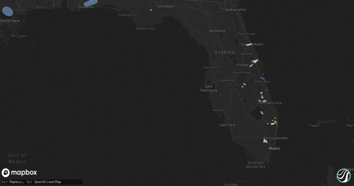
March 31 map
$229
one time, instant access
Download today. No call, no setup
Keep the $229
Bought the map and want the full workflow? Apply the entire $229 to a subscription within 7 days. None of it is wasted.
Every map, not just this one
This buys you this map. Subscription and you get every map we run, in the markets you choose from a few cities to whole states to nationwide. Plus real-time alerts the moment a storm fires.
Contact data
Name, contact info, occupancy, even credit band for addresses in the footprint. You go from where it hit to who to call.
Become the source they trust
Unlimited branding weather history reports on demand. You already have the documented answer ready for the property owner, and you are the one who showed up with it.
Property data and RoofTrace estimates
Pull up any address you have got, its value and the exact code rules for that jurisdiction, straight from One Click Code. Then RoofTrace estimates the squares, pitch, and roof value, priced the way you price.
Storm reports in Florida
Florida
| Date | Description |
|---|---|
| 03/31/20252:40 PM CDT | Emergency manager reports much of tram road covered in branches and about 4 trees down near and west of the intersection of tram road and saint joe road. |
| 03/31/20252:32 PM CDT | Emergency manager reported a tree down on a house. |
| 03/31/20252:32 PM CDT | Emergency manager reports a tree down near the intersection of pimlico drive and jamaica court. |
| 03/31/20252:19 PM CDT | Gadsden county dispatch reported a tree down in havana. Time estimated by radar. |
| 03/31/20251:38 PM CDT | Calhoun county florida dispatch reported a tree down along hwy 69 near macedonia church. |
| 03/31/20251:11 PM CDT | Corrects previous non-tstm wnd dmg report from 5 e round lake. Jackson county 911 dispatch reported a tree down near the intersection of fairview road and laramore road |
| 03/31/202512:55 PM CDT | Bay county emergency manager shared pictures of portions of the metal roof peeled off the oasis worship center along front beach road. Timing estimated by radar. |
| 03/31/202512:45 PM CDT | The west florida electric coop reported damage to several three-phase poles in the area of peanut road. |
| 03/31/202512:24 PM CDT | Holmes county emergency management reported a tree down along hwy 177a. Time estimated by radar. |
| 03/31/202512:20 PM CDT | Emergency management reported a tree down along j s jones rd. Time estimated by radar. |
| 03/31/202511:45 AM CDT | Walton county 911 dispatch reported several trees and powerlines down near the intersection of hwy 2 and us hwy 331. Time estimated by radar. |
| 03/31/202511:05 AM CDT | Minor shingle damage... Fences blown down... Decorative shutters blown off a home. |
| 03/31/202510:57 AM CDT | Asos station kpns pensacola observed a wind gust to 63mph. |
| 03/30/20257:27 PM CDT | Trained spotter reported quarter sized hail with passing thunderstorm. |
| 03/30/20257:21 PM CDT | Melbourne international airport measured a peak wind gust of 61mph/53kt from the northwest at 8:21 pm. Earlier... A gust to 52mph/45kt occurred at 8:20 pm. |
| 03/30/20257:12 PM CDT | Cocoa - patrick air force base measured a peak wind gust of 59mph/51kt from the northwest at 8:12 pm. |
All States Impacted by Hail Map on March 31, 2025
Cities Impacted by Hail Map on March 31, 2025
- Fayette, AL
- Berry, AL
- Bankston, AL
- Holden, LA
- Jeanerette, LA
- White Castle, LA
- Pierre Part, LA
- Gurley, AL
- Paint Rock, AL
- Carrollton, AL
- Franklin, LA
- Abbeville, LA
- Kaplan, LA
- Woodville, AL
- Belle Rose, LA
- Donaldsonville, LA
- Trenton, AL
- New Iberia, LA
- Morgan City, LA
- Princeton, AL
- Scottsboro, AL
- Hollytree, AL
- Emelle, AL
- Grand Chenier, LA
- Erath, LA
- Hollywood, AL
- Stevenson, AL
- Fackler, AL
- Flat Rock, AL
- Pisgah, AL
- Madisonville, LA
- Ponchatoula, LA
- Mandeville, LA
- Lacombe, LA
- Cottondale, AL
- Moundville, AL
- Knoxville, AL
- Birmingham, AL
- Leeds, AL
- Talladega, AL
- Vincent, AL
- Alpine, AL
- Cropwell, AL
- Cecil, AL
- Pike Road, AL
- Munford, AL
- Midway, AL
- Tallapoosa, GA
- Opelika, AL
- Salem, AL
- Buchanan, GA
- Cataula, GA
- Fortson, GA
- Newnan, GA
- Enterprise, AL
- Seale, AL
- Smiths Station, AL
- Atlanta, GA
- Midland City, AL
- Newville, AL
- Columbia, AL
- Headland, AL
- Blakely, GA
- Leesburg, GA
- Toccoa, GA
- Martin, GA
- Westminster, SC
- Seneca, SC
- Anderson, SC
- Clemson, SC
- Central, SC
- Williamston, SC
- Pendleton, SC
- Liberty, SC
- Pelzer, SC
- Townville, SC
- Hosford, FL
- Dexter, GA
- Cadwell, GA
- West Palm Beach, FL
- Eastman, GA
- Thomson, GA
- Washington, GA
- Lincolnton, GA
- Appling, GA
- Modoc, SC
- Augusta, GA
- Evans, GA
- Grovetown, GA
- Clarks Hill, SC
- North Augusta, SC
- Saluda, SC
- Plum Branch, SC
- Edgefield, SC
- Troy, SC
- Greenwood, SC
- Bradley, SC
- McCormick, SC
- Ninety Six, SC
- Rentz, GA
- Chula, GA
- Tifton, GA
- Abbeville, SC
- Dublin, GA
- Trenton, SC
- Johnston, SC
- Chappells, SC
- Ward, SC
- Ridge Spring, SC
- Swainsboro, GA
- Girard, GA
- Midville, GA
- Soperton, GA
- Barnwell, SC
- Williston, SC
- Lake Worth, FL
- Batesburg, SC
- Monetta, SC
- Martin, SC
- Prosperity, SC
- Leesville, SC
- Millen, GA
- Branchville, SC
- Gilbert, SC
- Lexington, SC
- Olar, SC
- Starr, SC
- Rowesville, SC
- Rocky Ford, GA
- Due West, SC
- Hodges, SC
- Honea Path, SC
- Iva, SC
- Donalds, SC
- Belton, SC
- Bowman, SC
- Santee, SC
- Holly Hill, SC
- Cope, SC
- Bamberg, SC
- Denmark, SC
- Vance, SC
- Eutawville, SC
- Fargo, GA
- Ruffin, SC
- Reevesville, SC
- Dorchester, SC
- Saint George, SC
- Smoaks, SC
- Harleyville, SC
- Cross, SC
- Manning, SC
- Pineville, SC
- Mico, TX
- Rio Medina, TX
- San Antonio, TX
- Daytona Beach, FL
- Adams Run, SC
- Round O, SC
- Ravenel, SC
- Williams, SC
- Saint Stephen, SC
- Moncure, NC
- Orlando, FL
- Orangeburg, SC
- Helotes, TX
- Pittsboro, NC
- Salters, SC
- Lane, SC
- Greeleyville, SC
- Bear Creek, NC
- Sanford, NC
- Jbsa Lackland, TX
- Lake Wales, FL
- New Hill, NC
- Christmas, FL
- Hondo, TX
- Mims, FL
- Indian Lake Estates, FL
- Apex, NC
- Titusville, FL
- Kingstree, SC
- Cary, NC
- Raleigh, NC
- Holly Springs, NC
- Bandera, TX
- Castroville, TX
- Wendell, NC
- Knightdale, NC
- Loxahatchee, FL
- Laredo, TX
- Mirando City, TX
- Vero Beach, FL
- Wellington, FL
- Okeechobee, FL
- Warminster, PA
- Hatboro, PA
- Horsham, PA
- Willow Grove, PA
- Abington, PA
- Chalfont, PA
- Gwynedd, PA
- Richboro, PA
- Glenside, PA
- Jenkintown, PA
- North Wales, PA
- Dresher, PA
- Huntingdon Valley, PA
- Spring House, PA
- Warrington, PA
- Montgomeryville, PA
- Southampton, PA
- Lansdale, PA
- Fort Washington, PA
- Ambler, PA
- Blue Bell, PA
- Bryn Athyn, PA
- Philadelphia, PA
- Flourtown, PA
- Oreland, PA
- Plymouth Meeting, PA
- Lafayette Hill, PA
- Gladwyne, PA
- Conshohocken, PA
- King Of Prussia, PA
- Narberth, PA
- Villanova, PA
- Bryn Mawr, PA
- Bala Cynwyd, PA
- Elkins Park, PA
- Newtown, PA
- Wyncote, PA
- Washington Crossing, PA
- Cheltenham, PA
- Feasterville Trevose, PA
- Langhorne, PA
- Titusville, NJ
- Bensalem, PA
- Morrisville, PA
- Bristol, PA
- Trenton, NJ
- Levittown, PA
- Fairless Hills, PA
- Pennington, NJ
- Princeton, NJ
- Lawrence Township, NJ
- Bowling Green, VA
- Champlain, VA
- Milford, VA
- Hustle, VA
- Caret, VA
- Aylett, VA
- Newtown, VA
- Tappahannock, VA
- Saint Stephens Church, VA
- King William, VA
- Fort Pierce, FL
- Port Royal, VA
- Woodford, VA
- Ruther Glen, VA
- Loretto, VA
- Warsaw, VA
- Montross, VA
- Issue, MD
- King George, VA
- Rappahannock Academy, VA
- Colonial Beach, VA
- Newburg, MD
- Leonardtown, MD
- Bushwood, MD
- Loveville, MD
- Cobb Island, MD
- Mechanicsville, MD
- Clements, MD
- Chaptico, MD
- Avenue, MD
- Abell, MD
- Coltons Point, MD
- Plainsboro, NJ
- Princeton Junction, NJ
- Cranbury, NJ
- Pine Bluffs, WY
- Bushnell, NE
- Canal Point, FL
- Port Saint Lucie, FL
- Bruni, TX
- Patrick Afb, FL
- Melbourne, FL
- Indialantic, FL
- Melbourne Beach, FL
- Millington, MD
- Massey, MD
- Galena, MD
- Sudlersville, MD
- Clayton, DE
- Smyrna, DE
- Townsend, DE
- Harrisburg, NE
- Kimball, NE
- Boynton Beach, FL
- Greenwich, NJ
- Gloucester, VA
- North, VA
- Dutton, VA
- Hartfield, VA
- Topping, VA
- Wake, VA
- Hardyville, VA
- Cobbs Creek, VA
- Deltaville, VA
- Dix, NE
- White Stone, VA
- Potter, NE
- Pensacola, FL
- Milton, FL
- Bagdad, FL
- Eglin Afb, FL
- Dothan, AL
- Newton, AL
- Eatonton, GA
- Laurens, SC


