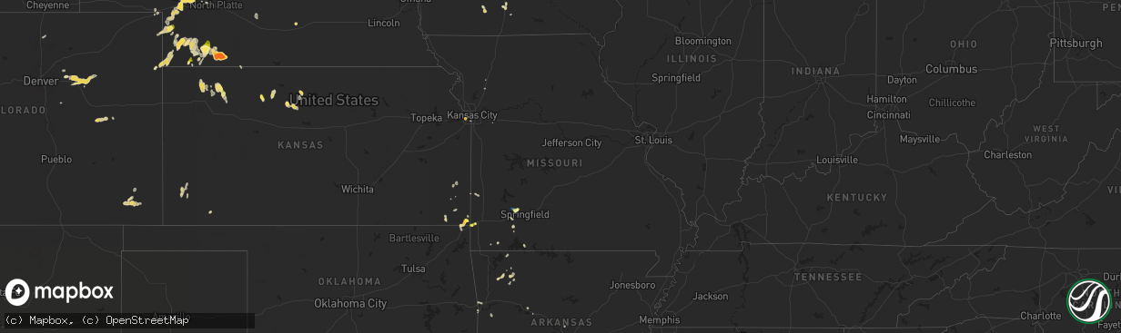
Hail Map in Missouri on September 16, 2025
The weather event in Missouri on September 16, 2025 includes Wind and Hail maps. 16 states and 530 cities were impacted and suffered possible damage. The total estimated number of properties impacted is 4,723.
Want more than just the map?
Turn this storm into a full workflow.
- Owner + property data so you know who to knock
- OnDemand branded weather history reports to win the "did we even have hail?" argument
- RoofTrace estimate so reps stop guessing numbers at the door
Bought this map? Upgrade within 7 days and we'll credit the $230. (10-15 min setup call)
Wind
Hail
4,723
Estimated number of impacted properties by a 1.00" hail or larger0
Estimated number of impacted properties by a 1.75" hail or larger0
Estimated number of impacted properties by a 2.50" hail or largerStorm reports in Missouri
Missouri
| Date | Description |
|---|---|
| 09/16/20256:46 PM CDT | Social media report of mostly pea to nickel size hail with a few stones up to quarter size between independence and blue springs. Time and location estimated from radar |
| 09/16/20256:35 PM CDT | 635 pm spotter reported quarter size hail... 40mph gusts... 1.5 miles east of ash grove. |
| 09/16/20256:27 PM CDT | Report from mping... Quarter... 1.00 in. |
| 09/16/20256:20 PM CDT | Several large tree limbs down. |
| 09/16/20256:20 PM CDT | Several large tree limbs down. |
| 09/16/20256:18 PM CDT | Power poles snapped and some structural damage. |
| 09/16/20256:18 PM CDT | Power poles snapped and s |
| 09/16/20256:10 PM CDT | A social media picture showed hail to the size of quarters in willard with a storm around 610pm. |
| 09/16/20256:05 PM CDT | Social media report of a large tree down on a property in rural ray county. Another report of up to quarter size hail north of orrick. Time and location estimated based |
| 09/16/20255:29 PM CDT | Report from mping... Quarter... 1.00 in. |
| 09/16/20255:24 PM CDT | Kshb-tv viewer shares photo of shed roof damage south of bates city. Stronger storm with subtle downburst divergence signature noted. Time estimated from radar. |
| 09/16/20253:32 PM CDT | A local report indicates 1.25 inch wind near 3 E I-44 Near Mile Mar |
| 09/16/20252:45 PM CDT | A few large trees down. |
| 09/15/20257:00 PM CDT | Kshb-tv viewer showed picture of 1 inch hail near parkville. |
All States Impacted by Hail Map on September 16, 2025
Cities Impacted by Hail Map on September 16, 2025
- Dallas, SD
- Platte, SD
- Chadron, NE
- Gregory, SD
- Hay Springs, NE
- Burke, SD
- Crawford, NE
- Whitney, NE
- Dexter, IA
- Redfield, IA
- Ellsworth, NE
- Bingham, NE
- Kosciusko, MS
- Sallis, MS
- Stuart, IA
- Britt, IA
- Vaughn, NM
- Woodburn, IA
- Lakeside, NE
- Kanawha, IA
- Garner, IA
- Magdalena, NM
- Ashby, NE
- Merriman, NE
- Castalian Springs, TN
- Hartsville, TN
- Lebanon, TN
- Fort Lauderdale, FL
- Hollywood, FL
- Miami, FL
- Miami Gardens, FL
- Hyannis, NE
- Goodell, IA
- Arthur, NE
- Lemoyne, NE
- Culbertson, NE
- Tallulah, LA
- Oshkosh, NE
- Roosevelt, UT
- McCook, NE
- Branson, MO
- Kilgore, NE
- Somers, IA
- Callender, IA
- Newellton, LA
- Osborne, KS
- Mason City, IA
- Indianola, MS
- Valentine, NE
- Louise, MS
- Silver City, MS
- Osceola, IA
- New Virginia, IA
- Mitchellville, IA
- Lu Verne, IA
- Livermore, IA
- Oberlin, LA
- Imperial, NE
- Benkelman, NE
- Hollister, MO
- Colfax, IA
- Joplin, MO
- Moorland, IA
- Downs, KS
- Coalmont, CO
- Damar, KS
- Cascilla, MS
- Bode, IA
- Alva, OK
- Portis, KS
- Ogallala, NE
- Keystone, NE
- Saint Joseph, LA
- Hoxie, KS
- Lamar, CO
- Champion, NE
- Bogue, KS
- Stockton, KS
- Van Buren, AR
- Gilbert, LA
- Clayton, LA
- Maywood, NE
- La Porte City, IA
- Evansdale, IA
- Waterloo, IA
- Lapoint, UT
- Fort Duchesne, UT
- Selden, KS
- Inverness, MS
- Rolling Fork, MS
- Cassville, MO
- Exeter, MO
- Estancia, NM
- Anguilla, MS
- Ocate, NM
- Wagon Mound, NM
- Natoma, KS
- Philadelphia, MS
- Doddsville, MS
- Boyle, MS
- Shaw, MS
- Springfield, CO
- Palisade, NE
- Enders, NE
- Clear Lake, IA
- Thornton, IA
- Lakin, KS
- Bradgate, IA
- Rockwell, IA
- Quapaw, OK
- Johnson, KS
- Sunflower, MS
- Goldfield, IA
- Myakka City, FL
- Washburn, MO
- Holcomb, MS
- Greenwood, MS
- Galena, KS
- Riverton, KS
- Lake Wales, FL
- Frostproof, FL
- Yazoo City, MS
- Vernal, UT
- Tridell, UT
- Venango, NE
- Grant, NE
- Burt, IA
- Lone Rock, IA
- Rockwell City, IA
- Lohrville, IA
- Alton, KS
- Waldo, KS
- Swaledale, IA
- McCune, KS
- Scammon, KS
- Norcatur, KS
- Wauneta, NE
- Rutland, IA
- Renwick, IA
- Apache, OK
- Freedom, OK
- Manson, IA
- Stratton, NE
- Miami, OK
- Fort Smith, AR
- Baxter Springs, KS
- Eureka Springs, AR
- Berryville, AR
- Fort Collins, CO
- Columbus, KS
- Paxton, NE
- Sutherland, NE
- Corwith, IA
- Ottosen, IA
- Creston, IA
- Redfield, KS
- Uniontown, KS
- Powell, MO
- Afton, IA
- Bradenton, FL
- Wilsonville, NE
- Ulysses, KS
- Picher, OK
- Treece, KS
- Las Vegas, NM
- Anton Chico, NM
- Hardy, IA
- Algona, IA
- West Bend, IA
- Cedar Falls, IA
- Cameron, MO
- Trenton, NE
- Wilder, TN
- Holly Bluff, MS
- Gilmore City, IA
- Kingston, AR
- Rockford, IA
- Windsor, CO
- Mooreland, OK
- Hudson, IA
- Huntsville, AR
- Rolfe, IA
- Osage, IA
- Sheffield, IA
- Lathrop, MO
- Bearden, AR
- Ackerman, MS
- West Mineral, KS
- Nora Springs, IA
- Dougherty, IA
- Hepler, KS
- Camden, AR
- Crawford, TN
- Leland, MS
- Oberlin, KS
- Marble Rock, IA
- Alexander, IA
- Pocahontas, IA
- Rudd, IA
- Whittemore, IA
- Tryon, NE
- Paradise, KS
- Wood Lake, NE
- Floyd, IA
- Orchard, IA
- Crumrod, AR
- Lamar, MO
- Algodones, NM
- Crane, MO
- Mallard, IA
- Eaton, CO
- Ault, CO
- Johnstown, NE
- Springview, NE
- Sparks, NE
- Indianola, NE
- Hampton, IA
- Fonda, IA
- Curlew, IA
- Liberal, MO
- Aredale, IA
- Marionville, MO
- Placitas, NM
- Fairland, OK
- Bartlett, KS
- Chetopa, KS
- Havelock, IA
- Billings, MO
- Buckingham, IA
- Strasburg, CO
- Bennett, CO
- Oswego, KS
- Mellwood, AR
- Conway, AR
- Laurens, IA
- Jonesville, LA
- Ainsworth, NE
- Long Pine, NE
- Ackley, IA
- Julesburg, CO
- Jolley, IA
- Girard, KS
- Bastrop, LA
- Walnut, KS
- Byers, CO
- Geneva, IA
- Dumont, IA
- Kiowa, CO
- Hugo, CO
- Dover, AR
- Rexford, KS
- Woodston, KS
- Witter, AR
- Colby, KS
- Morton, MS
- Emmetsburg, IA
- Hamburg, AR
- Pelahatchie, MS
- Hayes Center, NE
- Charles City, IA
- Wesley, AR
- Bates City, MO
- Sac City, IA
- Lytton, IA
- Russellville, AR
- London, AR
- Deer Trail, CO
- Monterey, LA
- Big Springs, NE
- Lake, MS
- Forest, MS
- Lexington, NE
- Pettigrew, AR
- Saint Paul, AR
- Shawnee, KS
- Greene, IA
- Allison, IA
- Bristow, IA
- Baskin, LA
- Rayville, LA
- Delhi, LA
- Atwood, KS
- Nashua, IA
- Haigler, NE
- Mission, KS
- Babbitt, MN
- Elkins, AR
- Liberal, KS
- Ely, MN
- Hershey, NE
- North Platte, NE
- Orrick, MO
- Willard, MO
- Republic, MO
- Kansas City, KS
- Pulaski, MS
- Clarksville, IA
- Early, IA
- Parks, NE
- Bois D Arc, MO
- Ash Grove, MO
- Wray, CO
- Kansas City, MO
- Palmer, IA
- Greenwood, AR
- Springfield, MO
- Holyoke, CO
- Amherst, CO
- Pottsville, AR
- Kismet, KS
- Plainfield, IA
- Waverly, IA
- Monroe, LA
- Downsville, LA
- West Monroe, LA
- Max, NE
- Fort Morgan, CO
- Woodrow, CO
- Stapleton, NE
- Shell Rock, IA
- Isabella, MN
- Lawrence, MS
- Gibbon, NE
- Shelton, NE
- Farmerville, LA
- Kaplan, LA
- Sterlington, LA
- Spencer, IA
- Hill City, KS
- Stanley, NM
- Mount Vernon, AR
- Lawson, MO
- Oak Grove, LA
- Pioneer, LA
- Eddyville, NE
- Ludell, KS
- Herndon, KS
- Nemaha, IA
- Acme, LA
- Pomeroy, IA
- Glade, KS
- Arnold, NE
- Akron, CO
- Lindon, CO
- Sumner, NE
- McDonald, KS
- Deridder, LA
- Pitkin, LA
- Lenora, KS
- Fort Dodge, IA
- Knierim, IA
- Saint Francis, KS
- Anselmo, NE
- Overton, NE
- Excelsior Springs, MO
- Rayville, MO
- Idalia, CO
- El Dorado, AR
- Merna, NE
- Marion, LA
- Cherokee, IA
- Broken Bow, NE
- Wahoo, NE
- Mason City, NE
- Oconto, NE
- Stephens, AR
- Ithaca, NE
- Fleming, CO
- Hardesty, OK
- Mountain Lake, MN
- Clare, IA
- Winnsboro, LA
- Ansley, NE
- Waverly, NE
- Crook, CO
- Logan, IA
- Missouri Valley, IA
- Aurelia, IA
- Bird City, KS
- Ceresco, NE
- Ashland, NE
- Saint Martinville, LA
- McNeil, AR
- Bingham Lake, MN
- Sedgwick, CO
- Duncombe, IA
- Otho, IA
- Lehigh, IA
- Burnside, IA
- Dayton, IA
- Choudrant, LA
- Ruston, LA
- Blair, NE
- Arcadia, NE
- Kennard, NE
- Arlington, NE
- Goodland, KS
- Burlington, CO
- Kanorado, KS
- Sheldon, IA
- Ashton, IA
- Sanborn, IA
- Bunkie, LA
- Westerville, NE
- Farnhamville, IA
- Barnum, IA
- Ord, NE
- Herman, NE
- Fremont, NE
- Independence, MO
- Fayetteville, AR
- Comstock, NE
- Loup City, NE
- North Loup, NE
- Scotia, NE
- Greenfield, IA
- Marcus, IA
- Valley, NE
- Magnolia, AR
- Hartsel, CO
- Greeley, NE
- Elyria, NE
- Melvin, IA
- Sleepy Eye, MN
- Remsen, IA
- Dunlap, IA
- Winterset, IA
- Menlo, IA
- Modale, IA
- Mondamin, IA
- Elm Creek, NE
- Miller, NE
- Macksburg, IA
- Stratford, IA
- Scribner, NE
- Hartley, IA
- Pilot Mound, IA
- Nickerson, NE
- Yutan, NE
- Colon, NE
- Dow City, IA
- Wolbach, NE
- Schuyler, NE
- Panora, IA
- Minden, NE
- Lynch, NE
- Eros, LA
- Ulysses, NE
- Leigh, NE
- Clarkson, NE
- Edson, KS
- Brewster, KS
- Arion, IA
- Rising City, NE
- Hooper, NE
- Holstein, IA
- David City, NE
- Levant, KS
- Rogers, NE
- Adel, IA
- Denison, IA
- Schleswig, IA
- Howells, NE
- Minburn, IA
- Quimby, IA
- Washta, IA
- Kenesaw, NE
- Columbus, NE
- Ida Grove, IA
- Battle Creek, IA
- Bellwood, NE
- Bruno, NE
- Wood River, NE
- Danbury, NE
- Heartwell, NE
- Perry, IA
- Brainard, NE
- Valparaiso, NE
- Dwight, NE
- Glidden, IA
- West Point, NE
- Dodge, NE
- Wisner, NE
- Juniata, NE
- Roseland, NE
- Holstein, NE
- Orient, IA
- Grand Junction, IA
- Weston, NE
- Bladen, NE
- Anthon, IA
- Ogden, IA
- Dresden, KS
- Tekamah, NE
- Jennings, KS
- Linden, IA
- Guthrie Center, IA
- Leawood, KS
- Sergeant Bluff, IA
- Casey, IA
- Ellis, KS
- Ogallah, KS
- Plainville, KS
- Woodbine, IA
- Linwood, NE
- Catharine, KS
- Victoria, KS
- Hays, KS
- Defiance, IA
- Calhoun, LA
- Lucas, KS
- Bennington, NE
- Washington, NE
- Luray, KS
- Sylvan Grove, KS
- Kimball, SD
- Baileyville, KS
- Greenwood, NE
- Pawnee City, NE
- Madison, SD
- Ramona, SD
- Bruce, SD
- Volga, SD
- Brookings, SD
- Mead, NE
- Star Prairie, WI
- Clayton, NM
- Clayton, WI
- Osceola, WI
- Sioux Falls, SD


