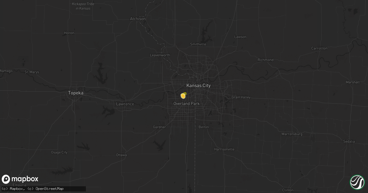
Hail Map in Shawnee, KS on September 16, 2025
Get this storm
September 16 map
$229
one time, instant access
Download today. No call, no setup
Keep the $229
Bought the map and want the full workflow? Apply the entire $229 to a subscription within 7 days. None of it is wasted.
Every map, not just this one
This buys you this map. Subscription and you get every map we run, in the markets you choose from a few cities to whole states to nationwide. Plus real-time alerts the moment a storm fires.
Contact data
Name, contact info, occupancy, even credit band for addresses in the footprint. You go from where it hit to who to call.
Become the source they trust
Unlimited branding weather history reports on demand. You already have the documented answer ready for the property owner, and you are the one who showed up with it.
Property data and RoofTrace estimates
Pull up any address you have got, its value and the exact code rules for that jurisdiction, straight from One Click Code. Then RoofTrace estimates the squares, pitch, and roof value, priced the way you price.
Storm reports in Shawnee, KS
Shawnee, KS
| Date | Description |
|---|---|
| 09/16/20256:22 PM CDT | Tree uprooted... Tree may not have been in good health. |
| 09/16/20256:12 PM CDT | Social media picture of quarter size hail. |
| 09/16/20256:10 PM CDT | Social media photo of hail up to half dollar size on knox street. Time estimated from radar. |
| 09/16/20256:09 PM CDT | Several reports of downed tree limbs and hail up to quarter size on 53rd street. Time estimated from radar. |
| 09/16/20256:08 PM CDT | A local report indicates 1.75 inch wind near 2 W Merriam |
| 09/16/20256:07 PM CDT | Report from mping: quarter |
| 09/16/20256:05 PM CDT | A local report indicates 1.00 inch wind near 1 NW Merriam |
| 09/16/20256:00 PM CDT | Report from mping: quarter |
All States Impacted by Hail Map on September 16, 2025
All Cities Impacted by Hail Map on September 16, 2025
- Dallas, SD
- Platte, SD
- Chadron, NE
- Gregory, SD
- Hay Springs, NE
- Burke, SD
- Crawford, NE
- Whitney, NE
- Dexter, IA
- Redfield, IA
- Ellsworth, NE
- Bingham, NE
- Kosciusko, MS
- Sallis, MS
- Stuart, IA
- Britt, IA
- Vaughn, NM
- Woodburn, IA
- Lakeside, NE
- Kanawha, IA
- Garner, IA
- Magdalena, NM
- Ashby, NE
- Merriman, NE
- Castalian Springs, TN
- Hartsville, TN
- Lebanon, TN
- Fort Lauderdale, FL
- Hollywood, FL
- Miami, FL
- Miami Gardens, FL
- Hyannis, NE
- Goodell, IA
- Arthur, NE
- Lemoyne, NE
- Culbertson, NE
- Tallulah, LA
- Oshkosh, NE
- Roosevelt, UT
- McCook, NE
- Branson, MO
- Kilgore, NE
- Somers, IA
- Callender, IA
- Newellton, LA
- Osborne, KS
- Mason City, IA
- Indianola, MS
- Valentine, NE
- Louise, MS
- Silver City, MS
- Osceola, IA
- New Virginia, IA
- Mitchellville, IA
- Lu Verne, IA
- Livermore, IA
- Oberlin, LA
- Imperial, NE
- Benkelman, NE
- Hollister, MO
- Colfax, IA
- Joplin, MO
- Moorland, IA
- Downs, KS
- Coalmont, CO
- Damar, KS
- Cascilla, MS
- Bode, IA
- Alva, OK
- Portis, KS
- Ogallala, NE
- Keystone, NE
- Saint Joseph, LA
- Hoxie, KS
- Lamar, CO
- Champion, NE
- Bogue, KS
- Stockton, KS
- Van Buren, AR
- Gilbert, LA
- Clayton, LA
- Maywood, NE
- La Porte City, IA
- Evansdale, IA
- Waterloo, IA
- Lapoint, UT
- Fort Duchesne, UT
- Selden, KS
- Inverness, MS
- Rolling Fork, MS
- Cassville, MO
- Exeter, MO
- Estancia, NM
- Anguilla, MS
- Ocate, NM
- Wagon Mound, NM
- Natoma, KS
- Philadelphia, MS
- Doddsville, MS
- Boyle, MS
- Shaw, MS
- Springfield, CO
- Palisade, NE
- Enders, NE
- Clear Lake, IA
- Thornton, IA
- Lakin, KS
- Bradgate, IA
- Rockwell, IA
- Quapaw, OK
- Johnson, KS
- Sunflower, MS
- Goldfield, IA
- Myakka City, FL
- Washburn, MO
- Holcomb, MS
- Greenwood, MS
- Galena, KS
- Riverton, KS
- Lake Wales, FL
- Frostproof, FL
- Yazoo City, MS
- Vernal, UT
- Tridell, UT
- Venango, NE
- Grant, NE
- Burt, IA
- Lone Rock, IA
- Rockwell City, IA
- Lohrville, IA
- Alton, KS
- Waldo, KS
- Swaledale, IA
- McCune, KS
- Scammon, KS
- Norcatur, KS
- Wauneta, NE
- Rutland, IA
- Renwick, IA
- Apache, OK
- Freedom, OK
- Manson, IA
- Stratton, NE
- Miami, OK
- Fort Smith, AR
- Baxter Springs, KS
- Eureka Springs, AR
- Berryville, AR
- Fort Collins, CO
- Columbus, KS
- Paxton, NE
- Sutherland, NE
- Corwith, IA
- Ottosen, IA
- Creston, IA
- Redfield, KS
- Uniontown, KS
- Powell, MO
- Afton, IA
- Bradenton, FL
- Wilsonville, NE
- Ulysses, KS
- Picher, OK
- Treece, KS
- Las Vegas, NM
- Anton Chico, NM
- Hardy, IA
- Algona, IA
- West Bend, IA
- Cedar Falls, IA
- Cameron, MO
- Trenton, NE
- Wilder, TN
- Holly Bluff, MS
- Gilmore City, IA
- Kingston, AR
- Rockford, IA
- Windsor, CO
- Mooreland, OK
- Hudson, IA
- Huntsville, AR
- Rolfe, IA
- Osage, IA
- Sheffield, IA
- Lathrop, MO
- Bearden, AR
- Ackerman, MS
- West Mineral, KS
- Nora Springs, IA
- Dougherty, IA
- Hepler, KS
- Camden, AR
- Crawford, TN
- Leland, MS
- Oberlin, KS
- Marble Rock, IA
- Alexander, IA
- Pocahontas, IA
- Rudd, IA
- Whittemore, IA
- Tryon, NE
- Paradise, KS
- Wood Lake, NE
- Floyd, IA
- Orchard, IA
- Crumrod, AR
- Lamar, MO
- Algodones, NM
- Crane, MO
- Mallard, IA
- Eaton, CO
- Ault, CO
- Johnstown, NE
- Springview, NE
- Sparks, NE
- Indianola, NE
- Hampton, IA
- Fonda, IA
- Curlew, IA
- Liberal, MO
- Aredale, IA
- Marionville, MO
- Placitas, NM
- Fairland, OK
- Bartlett, KS
- Chetopa, KS
- Havelock, IA
- Billings, MO
- Buckingham, IA
- Strasburg, CO
- Bennett, CO
- Oswego, KS
- Mellwood, AR
- Conway, AR
- Laurens, IA
- Jonesville, LA
- Ainsworth, NE
- Long Pine, NE
- Ackley, IA
- Julesburg, CO
- Jolley, IA
- Girard, KS
- Bastrop, LA
- Walnut, KS
- Byers, CO
- Geneva, IA
- Dumont, IA
- Kiowa, CO
- Hugo, CO
- Dover, AR
- Rexford, KS
- Woodston, KS
- Witter, AR
- Colby, KS
- Morton, MS
- Emmetsburg, IA
- Hamburg, AR
- Pelahatchie, MS
- Hayes Center, NE
- Charles City, IA
- Wesley, AR
- Bates City, MO
- Sac City, IA
- Lytton, IA
- Russellville, AR
- London, AR
- Deer Trail, CO
- Monterey, LA
- Big Springs, NE
- Lake, MS
- Forest, MS
- Lexington, NE
- Pettigrew, AR
- Saint Paul, AR
- Shawnee, KS
- Greene, IA
- Allison, IA
- Bristow, IA
- Baskin, LA
- Rayville, LA
- Delhi, LA
- Atwood, KS
- Nashua, IA
- Haigler, NE
- Mission, KS
- Babbitt, MN
- Elkins, AR
- Liberal, KS
- Ely, MN
- Hershey, NE
- North Platte, NE
- Orrick, MO
- Willard, MO
- Republic, MO
- Kansas City, KS
- Pulaski, MS
- Clarksville, IA
- Early, IA
- Parks, NE
- Bois D Arc, MO
- Ash Grove, MO
- Wray, CO
- Kansas City, MO
- Palmer, IA
- Greenwood, AR
- Springfield, MO
- Holyoke, CO
- Amherst, CO
- Pottsville, AR
- Kismet, KS
- Plainfield, IA
- Waverly, IA
- Monroe, LA
- Downsville, LA
- West Monroe, LA
- Max, NE
- Fort Morgan, CO
- Woodrow, CO
- Stapleton, NE
- Shell Rock, IA
- Isabella, MN
- Lawrence, MS
- Gibbon, NE
- Shelton, NE
- Farmerville, LA
- Kaplan, LA
- Sterlington, LA
- Spencer, IA
- Hill City, KS
- Stanley, NM
- Mount Vernon, AR
- Lawson, MO
- Oak Grove, LA
- Pioneer, LA
- Eddyville, NE
- Ludell, KS
- Herndon, KS
- Nemaha, IA
- Acme, LA
- Pomeroy, IA
- Glade, KS
- Arnold, NE
- Akron, CO
- Lindon, CO
- Sumner, NE
- McDonald, KS
- Deridder, LA
- Pitkin, LA
- Lenora, KS
- Fort Dodge, IA
- Knierim, IA
- Saint Francis, KS
- Anselmo, NE
- Overton, NE
- Excelsior Springs, MO
- Rayville, MO
- Idalia, CO
- El Dorado, AR
- Merna, NE
- Marion, LA
- Cherokee, IA
- Broken Bow, NE
- Wahoo, NE
- Mason City, NE
- Oconto, NE
- Stephens, AR
- Ithaca, NE
- Fleming, CO
- Hardesty, OK
- Mountain Lake, MN
- Clare, IA
- Winnsboro, LA
- Ansley, NE
- Waverly, NE
- Crook, CO
- Logan, IA
- Missouri Valley, IA
- Aurelia, IA
- Bird City, KS
- Ceresco, NE
- Ashland, NE
- Saint Martinville, LA
- McNeil, AR
- Bingham Lake, MN
- Sedgwick, CO
- Duncombe, IA
- Otho, IA
- Lehigh, IA
- Burnside, IA
- Dayton, IA
- Choudrant, LA
- Ruston, LA
- Blair, NE
- Arcadia, NE
- Kennard, NE
- Arlington, NE
- Goodland, KS
- Burlington, CO
- Kanorado, KS
- Sheldon, IA
- Ashton, IA
- Sanborn, IA
- Bunkie, LA
- Westerville, NE
- Farnhamville, IA
- Barnum, IA
- Ord, NE
- Herman, NE
- Fremont, NE
- Independence, MO
- Fayetteville, AR
- Comstock, NE
- Loup City, NE
- North Loup, NE
- Scotia, NE
- Greenfield, IA
- Marcus, IA
- Valley, NE
- Magnolia, AR
- Hartsel, CO
- Greeley, NE
- Elyria, NE
- Melvin, IA
- Sleepy Eye, MN
- Remsen, IA
- Dunlap, IA
- Winterset, IA
- Menlo, IA
- Modale, IA
- Mondamin, IA
- Elm Creek, NE
- Miller, NE
- Macksburg, IA
- Stratford, IA
- Scribner, NE
- Hartley, IA
- Pilot Mound, IA
- Nickerson, NE
- Yutan, NE
- Colon, NE
- Dow City, IA
- Wolbach, NE
- Schuyler, NE
- Panora, IA
- Minden, NE
- Lynch, NE
- Eros, LA
- Ulysses, NE
- Leigh, NE
- Clarkson, NE
- Edson, KS
- Brewster, KS
- Arion, IA
- Rising City, NE
- Hooper, NE
- Holstein, IA
- David City, NE
- Levant, KS
- Rogers, NE
- Adel, IA
- Denison, IA
- Schleswig, IA
- Howells, NE
- Minburn, IA
- Quimby, IA
- Washta, IA
- Kenesaw, NE
- Columbus, NE
- Ida Grove, IA
- Battle Creek, IA
- Bellwood, NE
- Bruno, NE
- Wood River, NE
- Danbury, NE
- Heartwell, NE
- Perry, IA
- Brainard, NE
- Valparaiso, NE
- Dwight, NE
- Glidden, IA
- West Point, NE
- Dodge, NE
- Wisner, NE
- Juniata, NE
- Roseland, NE
- Holstein, NE
- Orient, IA
- Grand Junction, IA
- Weston, NE
- Bladen, NE
- Anthon, IA
- Ogden, IA
- Dresden, KS
- Tekamah, NE
- Jennings, KS
- Linden, IA
- Guthrie Center, IA
- Leawood, KS
- Sergeant Bluff, IA
- Casey, IA
- Ellis, KS
- Ogallah, KS
- Plainville, KS
- Woodbine, IA
- Linwood, NE
- Catharine, KS
- Victoria, KS
- Hays, KS
- Defiance, IA
- Calhoun, LA
- Lucas, KS
- Bennington, NE
- Washington, NE
- Luray, KS
- Sylvan Grove, KS
- Kimball, SD
- Baileyville, KS
- Greenwood, NE
- Pawnee City, NE
- Madison, SD
- Ramona, SD
- Bruce, SD
- Volga, SD
- Brookings, SD
- Mead, NE
- Star Prairie, WI
- Clayton, NM
- Clayton, WI
- Osceola, WI
- Sioux Falls, SD


