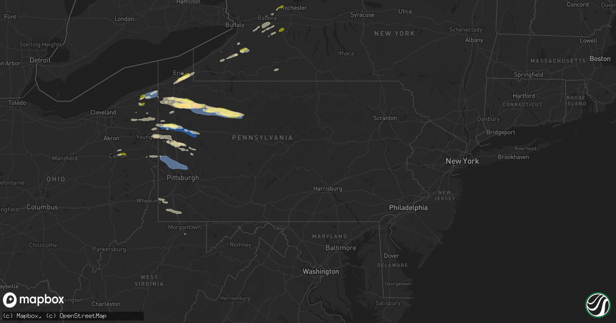
Hail Map in Pennsylvania on October 6, 2024
Get this storm
October 6 map
$229
one time, instant access
Download today. No call, no setup
Keep the $229
Bought the map and want the full workflow? Apply the entire $229 to a subscription within 7 days. None of it is wasted.
Every map, not just this one
This buys you this map. Subscription and you get every map we run, in the markets you choose from a few cities to whole states to nationwide. Plus real-time alerts the moment a storm fires.
Contact data
Name, contact info, occupancy, even credit band for addresses in the footprint. You go from where it hit to who to call.
Become the source they trust
Unlimited branding weather history reports on demand. You already have the documented answer ready for the property owner, and you are the one who showed up with it.
Property data and RoofTrace estimates
Pull up any address you have got, its value and the exact code rules for that jurisdiction, straight from One Click Code. Then RoofTrace estimates the squares, pitch, and roof value, priced the way you price.
Storm reports in Pennsylvania
Pennsylvania
| Date | Description |
|---|---|
| 10/06/20246:57 PM CDT | Trees and power lines down around economy area. |
| 10/06/20246:53 PM CDT | Trees and power lines around the baden... Pa area. |
| 10/06/20246:51 PM CDT | Report of uprooted trees as well as a tree down on a home in the ridewood housing plan near oakhaven drive. Time estimated based on radar. |
| 10/06/20246:35 PM CDT | Trees and wires down around patterson township. |
| 10/06/20246:31 PM CDT | Report from mping of 1-inch tree limbs broken and shingles blown off. |
| 10/06/20246:30 PM CDT | Trees snapped and uprooted along winterburn rd |
| 10/06/20246:25 PM CDT | Report of a tree down along the 300 block of west danville road. Time estimated based on radar. |
| 10/06/20246:14 PM CDT | Multiple trees down near route 368 and route 58. |
| 10/06/20246:14 PM CDT | Trees and wires down on euclid road. |
| 10/06/20246:14 PM CDT | Report of trees and powerlines down at intersection of south benbrook road and sawmill lane. Time estimated based on radar. |
| 10/06/20246:14 PM CDT | Report of tree down on house along with power lines along mahood road. Time estimated based on radar. |
| 10/06/20246:13 PM CDT | Trees down on munhood road. |
| 10/06/20246:10 PM CDT | Tree down on canoe ripple road and elliot road. |
| 10/06/20246:06 PM CDT | Report of a downed power line along west liberty road. Time estimated based on radar. |
| 10/06/20246:06 PM CDT | Report of pea to quarter size hail. Time estimated based on radar. |
| 10/06/20246:05 PM CDT | Multiple trees down around moraine state park area. |
| 10/06/20246:00 PM CDT | Report of treeds and power lines down along crolls mill road. Time estimated based on radar. |
| 10/06/20245:58 PM CDT | Tree down on village acres road. |
| 10/06/20245:58 PM CDT | Tree and power lines down near route 38 and metz road. |
| 10/06/20245:52 PM CDT | A local report indicates 1.00 inch wind near 2 WNW Marienville |
| 10/06/20245:44 PM CDT | Report from mping of 3-inch tree limbs broken and power poles broken. Time estimated based on radar. |
| 10/06/20245:35 PM CDT | Tree and power lines down near german hill road and jug handle road. |
| 10/06/20245:33 PM CDT | Trees down around new wilmington area. |
| 10/06/20245:33 PM CDT | 911 center reporting state route 956 closed due to powerlines down between sipe and mercer roads. Time estimated based on radar. |
| 10/06/20245:33 PM CDT | Tree down on riddle road. |
| 10/06/20245:32 PM CDT | A number of trees down in new wilmington area. |
| 10/06/20245:30 PM CDT | Trees down near dice run road and fox run road. |
| 10/06/20245:29 PM CDT | Trees and wires down. |
| 10/06/20245:27 PM CDT | Bluebird lane tree down. |
| 10/06/20245:23 PM CDT | Wind-driven hail cased damage to siding on homes. |
| 10/06/20245:18 PM CDT | Trees down across the road. |
| 10/06/20245:16 PM CDT | Power lines down on latonka drive. |
| 10/06/20245:15 PM CDT | A local report indicates 1.00 inch wind near Mercer |
| 10/06/20245:14 PM CDT | Tree down on fullingmill road. |
| 10/06/20245:14 PM CDT | Tree down on fullingmill road. |
| 10/06/20245:13 PM CDT | Pontoon boat capsized. No one on board and heavily damaged. |
| 10/06/20245:11 PM CDT | Numerous trees down. |
| 10/06/20245:11 PM CDT | A local report indicates 1.00 inch wind near 2 WSW Jackson Center |
| 10/06/20245:07 PM CDT | Report from mping of quarter size hail. Time estimated based on radar. |
| 10/06/20245:07 PM CDT | Tree down on patricia drive. |
| 10/06/20245:03 PM CDT | Tree down on mcdowell road and rutledge road. |
| 10/06/20245:03 PM CDT | Trees down on hopper road. |
| 10/06/20245:03 PM CDT | Tree down on delaware road. |
| 10/06/20245:00 PM CDT | Tree down buxston road/pond city lane. |
| 10/06/20245:00 PM CDT | Tree down across roadway on east main street. Time estimated via radar. |
| 10/06/20244:58 PM CDT | Several trees down in titusville. Time estimated via radar. |
| 10/06/20244:58 PM CDT | Tree down on sunville road. |
| 10/06/20244:55 PM CDT | Tree down meadville road. |
| 10/06/20244:55 PM CDT | Storm chaser reported ping pong hail along state highway 27. |
| 10/06/20244:54 PM CDT | Report from mping: ping pong ball |
| 10/06/20244:54 PM CDT | Tree down on wallaceville road. |
| 10/06/20244:53 PM CDT | Report from mping of trees uprooted or snapped and portions of a roof blown off. Time estimated based on radar. |
| 10/06/20244:50 PM CDT | Report from mping: 3-inch tree limbs broken. Time estimated via radar. |
| 10/06/20244:49 PM CDT | Report from mping of 3-inch tree limbs broken and power poles broken. Time estimated based on radar. |
| 10/06/20244:35 PM CDT | Report from mping: quarter |
| 10/06/20244:33 PM CDT | Several trees down on plank road in mead township. Time estimated via radar. |
| 10/06/20244:32 PM CDT | Several trees down along state route 27 east of meadville. Time estimated via radar. |
| 10/06/20244:26 PM CDT | Large branch down on wires near oakgrove aveue and barton road. Time estimated via radar. |
| 10/06/20244:25 PM CDT | Multiple trees and power lines down near bockman hollow road and sleepy hollow road. Time estimated by radar. |
| 10/06/20244:25 PM CDT | Quarter sized hail in greene township. Time estimated via radar. |
| 10/06/20244:22 PM CDT | Several trees and power lines down along state highway 198 and brookhouser road. Time was estimated by radar. |
| 10/05/20249:15 PM CDT | Tree down on smithfield-masontown road. |
| 10/05/20249:08 PM CDT | Tree down into wires. Time estimated via radar. |
| 10/05/20247:22 PM CDT | Report of babcock boulevard closed in shaler township due to downed trees and power lines. Time estimated based on radar. |
| 10/05/20247:15 PM CDT | Tree down at intersection of bakerstown road and route 8. Time estimated via radar. |
| 10/05/20247:14 PM CDT | Trees down on bakerstown road near pittsburgh north golf club. Time estimated via radar. |
| 10/05/20247:13 PM CDT | Numerous wires down around ramblewood. Time estimated via radar. |
| 10/05/20247:12 PM CDT | Tree down across valencia road. Time estimated via radar. |
| 10/05/20247:07 PM CDT | A few small trunks and large limbs snapped by thunderstorm wind. There was no evidence of a ground circulation noted...but considerable damage from a prior storm discov |
| 10/05/20247:06 PM CDT | At least 9 trees uprooted with no damage to structures. |
All States Impacted by Hail Map on October 6, 2024
Cities Impacted by Hail Map on October 6, 2024
- Rock Creek, OH
- Austinburg, OH
- Geneva, OH
- Jefferson, OH
- Millersburg, OH
- Waverly, OH
- Sugar Grove, OH
- Dresden, OH
- Otway, OH
- Rushville, OH
- Fredericksburg, OH
- Rome, OH
- Mogadore, OH
- Navarre, OH
- North Lawrence, OH
- Kent, OH
- North Canton, OH
- Burton, OH
- Lucasville, OH
- Owingsville, KY
- Clinton, OH
- Newark, OH
- Vanceburg, KY
- Heath, OH
- Massillon, OH
- Canal Fulton, OH
- Chillicothe, OH
- Warsaw, OH
- Mantua, OH
- Glenford, OH
- Rockbridge, OH
- Stout, OH
- Thornville, OH
- Laurelville, OH
- Garrettsville, OH
- Frazeysburg, OH
- Dalton, OH
- Lancaster, OH
- Akron, OH
- Hillsboro, KY
- Ravenna, OH
- Dundee, OH
- Coshocton, OH
- Uniontown, OH
- Londonderry, OH
- Piketon, OH
- Hiram, OH
- Nashport, OH
- Middlefield, OH
- Windsor, OH
- Orwell, OH
- Dorset, OH
- Pierpont, OH
- Conneaut, OH
- Kingsville, OH
- Conneautville, PA
- West Farmington, OH
- Linesville, PA
- Saegertown, PA
- Meadville, PA
- Bristolville, OH
- Cortland, OH
- Farmdale, OH
- McKean, PA
- Waterford, PA
- Erie, PA
- Conneaut Lake, PA
- Harmonsburg, PA
- Wattsburg, PA
- Union City, PA
- Guys Mills, PA
- Cambridge Springs, PA
- Townville, PA
- North East, PA
- Fowler, OH
- Kinsman, OH
- Cochranton, PA
- Titusville, PA
- Centerville, PA
- Hydetown, PA
- Transfer, PA
- Greenville, PA
- Warren, OH
- Niles, OH
- Vienna, OH
- Attica, NY
- Clymer, NY
- Findley Lake, NY
- Burghill, OH
- Clark, PA
- Sharpsville, PA
- Forestville, NY
- Cherry Creek, NY
- Pleasantville, PA
- Fredonia, PA
- Mercer, PA
- Brookfield, OH
- Hubbard, OH
- Atlantic, PA
- Alexander, NY
- East Bethany, NY
- North Collins, NY
- Youngstown, OH
- Cattaraugus, NY
- Dayton, NY
- South Dayton, NY
- Gowanda, NY
- Cooperstown, PA
- Hermitage, PA
- Masury, OH
- Collins, NY
- Springville, NY
- Tionesta, PA
- Jackson Center, PA
- Stoneboro, PA
- Tidioute, PA
- West Hickory, PA
- West Middlesex, PA
- Lowellville, OH
- Pulaski, PA
- East Otto, NY
- West Valley, NY
- Campbell, OH
- Batavia, NY
- East Hickory, PA
- Dale, NY
- Warsaw, NY
- Wyoming, NY
- Endeavor, PA
- Marienville, PA
- Sheffield, PA
- New Castle, PA
- Volant, PA
- New Wilmington, PA
- Harrisville, PA
- Kennerdell, PA
- Grove City, PA
- Sigel, PA
- James City, PA
- Byron, NY
- Eden, NY
- Pavilion, NY
- Strykersville, NY
- Cowlesville, NY
- Emlenton, PA
- Parker, PA
- Delevan, NY
- East Concord, NY
- Slippery Rock, PA
- Clintonville, PA
- Ridgway, PA
- Rogers, OH
- Lisbon, OH
- Perry, NY
- Foxburg, PA
- Portersville, PA
- Edinburg, PA
- Butler, PA
- East Aurora, NY
- Darien Center, NY
- Grand Valley, PA
- South Byron, NY
- West Sunbury, PA
- Negley, OH
- New Waterford, OH
- Darlington, PA
- East Palestine, OH
- Chicora, PA
- Ripley, NY
- Edinboro, PA
- Johnsonburg, PA
- Prospect, PA
- Saint Marys, PA
- Fenelton, PA
- Belmont, NY
- Scio, NY
- Wellsville, NY
- Warrendale, PA
- Silver Springs, NY
- Brockport, NY
- Bergen, NY
- Varysburg, NY
- West Alexander, PA
- Claysville, PA
- West Finley, PA
- Prosperity, PA
- Sycamore, PA
- Waynesburg, PA
- East Canton, OH
- Canton, OH
- Louisville, OH
- Middlebranch, OH
- North Bloomfield, OH
- Jefferson, PA
- Carmichaels, PA
- Morgantown, WV
- Leicester, NY
- Piffard, NY
- Geneseo, NY
- Retsof, NY
- Spencerport, NY
- Cabot, PA
- Oil City, PA
- Vowinckel, PA
- Boyers, PA
- Eau Claire, PA
- Hilliards, PA
- Polk, PA
- Conway, PA
- Beaver Falls, PA
- Industry, PA
- Freedom, PA
- Rochester, PA
- Baden, PA
- Beaver, PA
- New Brighton, PA
- Monaca, PA
- Ambridge, PA
- Aliquippa, PA
- Sewickley, PA
- Wexford, PA
- Pittsburgh, PA
- Mars, PA
- Cranberry Township, PA
- Bradfordwoods, PA
- Allison Park, PA
- Gibsonia, PA
- Cheswick, PA
- Zelienople, PA


