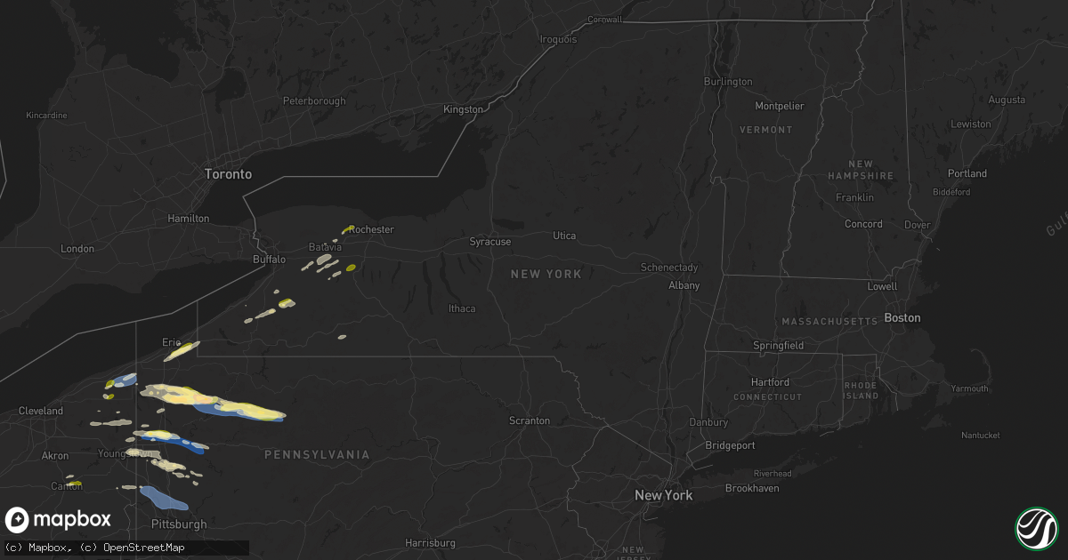
Hail Map in New York on October 6, 2024
Get this storm
October 6 map
$229
one time, instant access
Download today. No call, no setup
Keep the $229
Bought the map and want the full workflow? Apply the entire $229 to a subscription within 7 days. None of it is wasted.
Every map, not just this one
This buys you this map. Subscription and you get every map we run, in the markets you choose from a few cities to whole states to nationwide. Plus real-time alerts the moment a storm fires.
Contact data
Name, contact info, occupancy, even credit band for addresses in the footprint. You go from where it hit to who to call.
Become the source they trust
Unlimited branding weather history reports on demand. You already have the documented answer ready for the property owner, and you are the one who showed up with it.
Property data and RoofTrace estimates
Pull up any address you have got, its value and the exact code rules for that jurisdiction, straight from One Click Code. Then RoofTrace estimates the squares, pitch, and roof value, priced the way you price.
Storm reports in New York
New York
| Date | Description |
|---|---|
| 10/06/20246:59 PM CDT | Tree down on haley road. |
| 10/06/20246:58 PM CDT | Tree down blocking road. |
| 10/06/20246:51 PM CDT | Trees and wires down. |
| 10/06/20246:43 PM CDT | Tree down blocking road at the intersection of wilkinson and wayneport road. |
| 10/06/20246:26 PM CDT | Trees and wires down. |
| 10/06/20246:22 PM CDT | Tree down on road. |
| 10/06/20246:21 PM CDT | Tree down on road. |
| 10/06/20246:13 PM CDT | Tree down on road. |
| 10/06/20246:09 PM CDT | North side of leicester. |
| 10/06/20246:07 PM CDT | Tree down on route 98. |
| 10/06/20245:57 PM CDT | A local report indicates 1.00 inch wind near 3 WSW Spencerport |
| 10/06/20245:52 PM CDT | Trees down on power lines. |
| 10/06/20245:40 PM CDT | Trees down on power lines. |
| 10/06/20245:38 PM CDT | Tree and power lines down; 4th street as well as eagle street. |
| 10/06/20245:37 PM CDT | Trees down on power lines. |
| 10/06/20245:20 PM CDT | A local report indicates 1.00 inch wind near Springville |
| 10/05/20247:24 PM CDT | Tree down blocking road. |
| 10/05/20247:07 PM CDT | Tree down blocking road. |
All States Impacted by Hail Map on October 6, 2024
Cities Impacted by Hail Map on October 6, 2024
- Rock Creek, OH
- Austinburg, OH
- Geneva, OH
- Jefferson, OH
- Millersburg, OH
- Waverly, OH
- Sugar Grove, OH
- Dresden, OH
- Otway, OH
- Rushville, OH
- Fredericksburg, OH
- Rome, OH
- Mogadore, OH
- Navarre, OH
- North Lawrence, OH
- Kent, OH
- North Canton, OH
- Burton, OH
- Lucasville, OH
- Owingsville, KY
- Clinton, OH
- Newark, OH
- Vanceburg, KY
- Heath, OH
- Massillon, OH
- Canal Fulton, OH
- Chillicothe, OH
- Warsaw, OH
- Mantua, OH
- Glenford, OH
- Rockbridge, OH
- Stout, OH
- Thornville, OH
- Laurelville, OH
- Garrettsville, OH
- Frazeysburg, OH
- Dalton, OH
- Lancaster, OH
- Akron, OH
- Hillsboro, KY
- Ravenna, OH
- Dundee, OH
- Coshocton, OH
- Uniontown, OH
- Londonderry, OH
- Piketon, OH
- Hiram, OH
- Nashport, OH
- Middlefield, OH
- Windsor, OH
- Orwell, OH
- Dorset, OH
- Pierpont, OH
- Conneaut, OH
- Kingsville, OH
- Conneautville, PA
- West Farmington, OH
- Linesville, PA
- Saegertown, PA
- Meadville, PA
- Bristolville, OH
- Cortland, OH
- Farmdale, OH
- McKean, PA
- Waterford, PA
- Erie, PA
- Conneaut Lake, PA
- Harmonsburg, PA
- Wattsburg, PA
- Union City, PA
- Guys Mills, PA
- Cambridge Springs, PA
- Townville, PA
- North East, PA
- Fowler, OH
- Kinsman, OH
- Cochranton, PA
- Titusville, PA
- Centerville, PA
- Hydetown, PA
- Transfer, PA
- Greenville, PA
- Warren, OH
- Niles, OH
- Vienna, OH
- Attica, NY
- Clymer, NY
- Findley Lake, NY
- Burghill, OH
- Clark, PA
- Sharpsville, PA
- Forestville, NY
- Cherry Creek, NY
- Pleasantville, PA
- Fredonia, PA
- Mercer, PA
- Brookfield, OH
- Hubbard, OH
- Atlantic, PA
- Alexander, NY
- East Bethany, NY
- North Collins, NY
- Youngstown, OH
- Cattaraugus, NY
- Dayton, NY
- South Dayton, NY
- Gowanda, NY
- Cooperstown, PA
- Hermitage, PA
- Masury, OH
- Collins, NY
- Springville, NY
- Tionesta, PA
- Jackson Center, PA
- Stoneboro, PA
- Tidioute, PA
- West Hickory, PA
- West Middlesex, PA
- Lowellville, OH
- Pulaski, PA
- East Otto, NY
- West Valley, NY
- Campbell, OH
- Batavia, NY
- East Hickory, PA
- Dale, NY
- Warsaw, NY
- Wyoming, NY
- Endeavor, PA
- Marienville, PA
- Sheffield, PA
- New Castle, PA
- Volant, PA
- New Wilmington, PA
- Harrisville, PA
- Kennerdell, PA
- Grove City, PA
- Sigel, PA
- James City, PA
- Byron, NY
- Eden, NY
- Pavilion, NY
- Strykersville, NY
- Cowlesville, NY
- Emlenton, PA
- Parker, PA
- Delevan, NY
- East Concord, NY
- Slippery Rock, PA
- Clintonville, PA
- Ridgway, PA
- Rogers, OH
- Lisbon, OH
- Perry, NY
- Foxburg, PA
- Portersville, PA
- Edinburg, PA
- Butler, PA
- East Aurora, NY
- Darien Center, NY
- Grand Valley, PA
- South Byron, NY
- West Sunbury, PA
- Negley, OH
- New Waterford, OH
- Darlington, PA
- East Palestine, OH
- Chicora, PA
- Ripley, NY
- Edinboro, PA
- Johnsonburg, PA
- Prospect, PA
- Saint Marys, PA
- Fenelton, PA
- Belmont, NY
- Scio, NY
- Wellsville, NY
- Warrendale, PA
- Silver Springs, NY
- Brockport, NY
- Bergen, NY
- Varysburg, NY
- West Alexander, PA
- Claysville, PA
- West Finley, PA
- Prosperity, PA
- Sycamore, PA
- Waynesburg, PA
- East Canton, OH
- Canton, OH
- Louisville, OH
- Middlebranch, OH
- North Bloomfield, OH
- Jefferson, PA
- Carmichaels, PA
- Morgantown, WV
- Leicester, NY
- Piffard, NY
- Geneseo, NY
- Retsof, NY
- Spencerport, NY
- Cabot, PA
- Oil City, PA
- Vowinckel, PA
- Boyers, PA
- Eau Claire, PA
- Hilliards, PA
- Polk, PA
- Conway, PA
- Beaver Falls, PA
- Industry, PA
- Freedom, PA
- Rochester, PA
- Baden, PA
- Beaver, PA
- New Brighton, PA
- Monaca, PA
- Ambridge, PA
- Aliquippa, PA
- Sewickley, PA
- Wexford, PA
- Pittsburgh, PA
- Mars, PA
- Cranberry Township, PA
- Bradfordwoods, PA
- Allison Park, PA
- Gibsonia, PA
- Cheswick, PA
- Zelienople, PA


