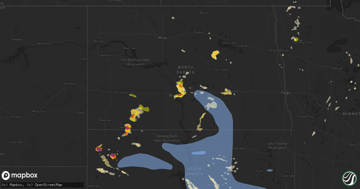
Hail Map on July 9, 2025
Get this storm
July 9 map
$229
one time, instant access
Download today. No call, no setup
Keep the $229
Bought the map and want the full workflow? Apply the entire $229 to a subscription within 7 days. None of it is wasted.
Every map, not just this one
This buys you this map. Subscription and you get every map we run, in the markets you choose from a few cities to whole states to nationwide. Plus real-time alerts the moment a storm fires.
Contact data
Name, contact info, occupancy, even credit band for addresses in the footprint. You go from where it hit to who to call.
Become the source they trust
Unlimited branding weather history reports on demand. You already have the documented answer ready for the property owner, and you are the one who showed up with it.
Property data and RoofTrace estimates
Pull up any address you have got, its value and the exact code rules for that jurisdiction, straight from One Click Code. Then RoofTrace estimates the squares, pitch, and roof value, priced the way you price.
States Impacted by Hail Map on July 9, 2025
Storm reports
Wyoming
| Date | Description |
|---|---|
| 07/09/20256:32 PM CDT | Mesonet station kctd wamsutter 10.5 e |
| 07/09/20255:54 PM CDT | Asos station krks roc |
| 07/09/20255:54 PM CDT | Asos station krks rock springs airport. |
| 07/09/20252:08 AM CDT | Mesonet station kctd wamsutter 10.5 e |
| 07/08/202511:38 PM CDT | Asos station krks rock springs airport. |
| 07/08/202510:24 PM CDT | Wind gust recorded at i80/us189 - first divide mesonet site. |
| 07/08/20259:43 PM CDT | Measured at the muddy creek raws site. |
| 07/08/20259:30 PM CDT | Wind gust recorded at fort bridger wy awos. |
| 07/08/20259:06 PM CDT | Measured at the i-80 french wydot rwis site. |
| 07/08/20258:56 PM CDT | Measured at the i-80 leroy wydot rwis site. |
Pennsylvania
| Date | Description |
|---|---|
| 07/09/20255:36 PM CDT | Tree down over the roadway at century farms road. |
| 07/09/20255:34 PM CDT | Tree down over the roadway at cross roads ave. |
| 07/09/20255:20 PM CDT | Corrects previous flash flood report to tstorm wind damage report from 1 ese willow street. Trees and wires down at beaver valley pike and penn grant road. |
| 07/09/20255:10 PM CDT | Pa-741 is closed at the intersection of new danville pike and marticville road due to down trees and wires making the road impassable. |
| 07/09/20255:02 PM CDT | Trees and wires down on blue ridge drive and oak ridge drive. |
| 07/09/20254:59 PM CDT | Wires down blocking the roadway at lake road. |
| 07/09/20253:12 PM CDT | Roof blown off a structure and multiple trees down. |
West Virginia
| Date | Description |
|---|---|
| 07/09/202512:40 PM CDT | Time estimated from radar. |
| 07/09/202512:01 PM CDT | Downed trees near smoke camp road resulted in local power outages. Time estimated from radar. |
| 07/09/202511:10 AM CDT | Tree down across oil ridge rd near cairo rd. Time estimated via radar. |
New Jersey
| Date | Description |
|---|---|
| 07/08/20259:06 PM CDT | 50 kt gust at nos gauge at cape may lewes ferry terminal. |
Idaho
| Date | Description |
|---|---|
| 07/08/20258:57 PM CDT | Station idarng3_d2. |
| 07/08/20258:45 PM CDT | Station itde7. |
| 07/08/20258:25 PM CDT | Station idarng2 rg14. |
| 07/08/20257:30 PM CDT | Station 032id. |
Virginia
| Date | Description |
|---|---|
| 07/09/20256:23 PM CDT | Tree reported down at the intersection of oak row rd. And rosehill drive. Radar estimated time. |
| 07/09/20256:20 PM CDT | Reports of multiple trees down near the intersection of yorkers swamp rd. And colnbrook rd. Radar estimated time. |
| 07/09/20256:18 PM CDT | Tree down near the intersection of tidewater trail and berry hill road. Radar estimated time. |
| 07/09/20256:13 PM CDT | A tree fell along king william rd. |
| 07/09/20256:10 PM CDT | A tree fell down at the intersection of club commons rd and old wyndham dr. |
| 07/09/20256:10 PM CDT | A tree fell down across namozine rd. |
| 07/09/20256:08 PM CDT | A tree fell on a house on chayton ln. No injuries were reported. Radar estimated time. |
| 07/09/20255:55 PM CDT | A tree fell along hermitage rd. |
| 07/09/20255:50 PM CDT | Tree reported down at the intersection of lewiston plank rd. And old school house rd. Time estimated from radar. |
| 07/09/20255:36 PM CDT | A tree fell down along river road west. |
| 07/09/20255:36 PM CDT | Tree reported down at the 2800 block of bible rd. Time estimated from radar. |
| 07/09/20255:36 PM CDT | A tree fell down along dykeland rd. |
| 07/09/20255:35 PM CDT | A tree fell across liberty fork rd. |
| 07/09/20255:35 PM CDT | A tree fell at the intersection of liberty fork rd and beverly run rd. |
| 07/09/20255:34 PM CDT | Power line down in crewe with power outages. Time estimated from radar. |
| 07/09/20255:31 PM CDT | Tree damage was reported on saint james rd. Radar estimated time. |
| 07/09/20255:30 PM CDT | A tree fell down at the intersection of three bridge rd and maidens rd. |
| 07/09/20255:30 PM CDT | Tree damage reported on meade rd. Radar estimated time. |
| 07/09/20255:27 PM CDT | Tree down at mathias point rd and bundock rd |
| 07/09/20255:27 PM CDT | Tree down in the 200 block of n payne street... Blocking both lanes. |
| 07/09/20255:27 PM CDT | Tree down at intersection of russell road and w myrtle street... Blocking both lanes. |
| 07/09/20255:26 PM CDT | Tree down in the 4800 block of arlington blvd. |
| 07/09/20255:26 PM CDT | Tree down at the intersection of duke st and cambridge rd... Blocking one lane. |
| 07/09/20255:24 PM CDT | Thunderstorm winds blew down one tree along green rock hills lane. |
| 07/09/20255:21 PM CDT | Thunderstorm winds blew down one tree near the 300 block of union cemetery road. |
| 07/09/20255:21 PM CDT | Thunderstorm winds blew down one tree near the 300 block of welsh tract road. |
| 07/09/20255:21 PM CDT | Thunderstorm winds blew down one tree along the 1200 block of barnesville highway. |
| 07/09/20255:19 PM CDT | Tree down on car along melon road. |
| 07/09/20255:17 PM CDT | Tree down near indiantown rd and kings hwy |
| 07/09/20255:15 PM CDT | Reports of a few trees down in mount vernon. |
| 07/09/20255:15 PM CDT | Tree fell on power line. |
| 07/09/20255:14 PM CDT | A tree fell down at the intersection of clementown rd and old buckingham rd. |
| 07/09/20255:14 PM CDT | A tree fell down along clement town rd. |
| 07/09/20255:10 PM CDT | Tree fell onto house. Power lines also down. |
| 07/09/20255:10 PM CDT | A tree fell along ballsville rd. |
| 07/09/20255:00 PM CDT | Tree down... Completely blocking road. |
| 07/09/20255:00 PM CDT | Tree down. |
| 07/09/20254:53 PM CDT | Reports of a few trees down in clifton. |
| 07/09/20254:53 PM CDT | Trees onto powerlines at 15034 alabama ave |
| 07/09/20254:52 PM CDT | Tree on power line. |
| 07/09/20254:49 PM CDT | Numerous trees down across the city of stafford. |
| 07/09/20254:49 PM CDT | Tree down. Blocking both lanes near intersection of halifax and coleman mountain rd. |
| 07/09/20254:42 PM CDT | Tree down at delaney rd and minnieville rd |
| 07/09/20254:42 PM CDT | Tree down on curdsville road. |
| 07/09/20254:42 PM CDT | Thunderstorm winds blew down one tree near the intersection of old curdsville road and bishop creek road and buckingham springs road. |
| 07/09/20254:42 PM CDT | Reported by public. |
| 07/09/20254:40 PM CDT | Tree down on bragg street. Radar estimated time. |
| 07/09/20254:37 PM CDT | Thunderstorm winds blew down one tree near the intersection of rolling hill road and price road. |
| 07/09/20254:34 PM CDT | Thunderstorm winds blew down one tree along the 6700 block of axton road. |
| 07/09/20254:32 PM CDT | Tree down on worsham rd. Radar estimated time. |
| 07/09/20254:30 PM CDT | Tree down at the intersection of sillamon rd. And backwell mills rd. |
| 07/09/20254:27 PM CDT | Thunderstorm winds blew down one tree on bear creek road. |
| 07/09/20254:26 PM CDT | Tree down at the intersection of howard trail. And river rd. |
| 07/09/20254:25 PM CDT | Multiple trees down near old church rd and slate run ln |
| 07/09/20254:24 PM CDT | Thunderstorm winds blew down one tree near the intersection of route 460 and hixburg road. |
| 07/09/20254:22 PM CDT | Thunderstorm winds blew down one tree along the 2200 block of red house |
| 07/09/20254:22 PM CDT | Thunderstorm winds blew down one tree along the 2200 block of red house road. |
| 07/09/20254:19 PM CDT | Tree across road. |
| 07/09/20254:17 PM CDT | Tree down across powerline. |
| 07/09/20254:17 PM CDT | Tree down on hall road. |
| 07/09/20254:15 PM CDT | Tree limb across power line. Power is out. |
| 07/09/20254:15 PM CDT | Tree down on road near intersection of central church rd and promise land rd. |
| 07/09/20254:12 PM CDT | Tree down at the intersection of oak mill rd. And clifton ln. |
| 07/09/20254:10 PM CDT | Multiple trees and large branches down at 6975 courthouse... Va. This is at the spotsylvania high school. |
| 07/09/20254:10 PM CDT | Thunderstorm winds blew down one tree near the intersection of central church road and warren lane. |
| 07/09/20254:10 PM CDT | Tree on power line. |
| 07/09/20254:09 PM CDT | Thunderstorm winds blew down one tree along the 2600 block of promise land road. |
| 07/09/20254:07 PM CDT | Tree down at the intersection of post oak rd. And curtis ln. |
| 07/09/20254:01 PM CDT | Tree down. Blocking most of road. |
| 07/09/20254:00 PM CDT | Tree across power line. |
| 07/09/20254:00 PM CDT | Tree across road. |
| 07/09/20254:00 PM CDT | Tree down resulting in power outages. |
| 07/09/20253:56 PM CDT | Tree down... Blocking 1 lane of william f |
| 07/09/20253:56 PM CDT | Tree down... Blocking 1 lane of william f stone hwy. |
| 07/09/20253:56 PM CDT | Tree fell on power line. |
| 07/09/20253:55 PM CDT | Tree fell on top of a house and came through roof...visible inside of house. |
| 07/09/20253:50 PM CDT | Tree down on power line. Near entrance to rich acres school. |
| 07/09/20253:50 PM CDT | Tree fell on house. Came through into kitchen and bathroom. |
| 07/09/20253:50 PM CDT | A tree fell along three chopt rd. |
| 07/09/20253:50 PM CDT | Tree down across power lines and blocking highway... Along fishers farm road and oxford drive. |
| 07/09/20253:48 PM CDT | Thunderstorm winds blew down one tree on route 58 bypass and route 220 just north of the joseph martin highway exit. |
| 07/09/20253:46 PM CDT | Tree down in the 100 block of lakeview dr. |
| 07/09/20253:40 PM CDT | Tree down. Traffic light out. |
| 07/09/20253:37 PM CDT | Large tree down near intersection of zachary taylor hwy and grasty ln |
| 07/09/20253:31 PM CDT | Two trees reported down in stanley on us-340 and keystone road. |
| 07/09/20253:30 PM CDT | Tree down... Blocking one lane of old mtn rd. |
| 07/09/20253:29 PM CDT | Thunderstorm winds blew down one tree near the intersection of machinery drive and business route 58. |
| 07/09/20253:24 PM CDT | Thunderstorm winds blew down one tree on to koehler road. |
| 07/09/20253:24 PM CDT | Thunderstorm winds blew down one tree along the 1900 block of stultz road. |
| 07/09/20253:22 PM CDT | Tree down on eagle mountain drive. |
| 07/09/20253:17 PM CDT | Tree down across the 7000 block of courthouse road |
| 07/09/20253:05 PM CDT | Thunderstorm winds blew down one tree on to the 100 block of anstey road. |
| 07/09/20253:00 PM CDT | Tree down near colonial highway. |
| 07/09/20252:52 PM CDT | Thunderstorm winds blew down one tree near the intersection of oak level road and edgewood drive. |
| 07/09/20252:50 PM CDT | Tree down on adial road. |
| 07/09/20252:49 PM CDT | Multiple trees down reported in the town of amherst. |
| 07/09/20252:45 PM CDT | Multiple reports of trees down on paynes mill rd. Time estimated by radar. |
| 07/09/20252:45 PM CDT | Multiple reports of trees down on p |
| 07/09/20252:36 PM CDT | Tree down on stagebridge road at wild cherry lane. |
| 07/09/20252:32 PM CDT | Tree down near intersection of ivanhoe road and painters hill road. |
| 07/09/20252:16 PM CDT | Tree down reported in potts creek. |
| 07/09/20252:16 PM CDT | Tree down reported in potts creek. |
| 07/09/20252:13 PM CDT | Tree down reported in hays gap. |
| 07/09/20252:11 PM CDT | Siding blown off of building. |
| 07/09/20252:11 PM CDT | Siding b |
| 07/09/20252:04 PM CDT | Tree down on the 1200 block of stuarts draft highway near walnut hills road. |
| 07/09/20252:04 PM CDT | Tree down northeast of bedford city. |
| 07/09/20251:51 PM CDT | 2 tree downs near hampton inn off e nelson st in lexington... Va. |
| 07/09/20251:40 PM CDT | Tree down near intersection of cedar springs and asbury church road. |
| 07/09/20251:34 PM CDT | Portion of a large tree fell onto utility lines and across alderman rd. |
| 07/09/20251:34 PM CDT | Thunderstorm winds blew down one tree near the intersection of route 43 and route 221. |
| 07/09/20251:32 PM CDT | Tree down and partially blocking lane at 3500 webster rd near the glade hill community. |
| 07/09/20251:24 PM CDT | Thunderstorm winds blew down one tree along power dam road near the bridge crossing over route 220. |
| 07/09/20251:00 PM CDT | Tree down near wards gap road. |
| 07/09/202512:56 PM CDT | Thunderstorm winds blew down a power line that caused a transformer to stop working. |
| 07/09/202512:50 PM CDT | Thunderstorm winds blew down one tree near the 3200 block of oak ridge road. |
| 07/09/202512:48 PM CDT | Tree down near mountain breeze lane. |
| 07/09/202512:40 PM CDT | Thunderstorm winds blew down one tree along the 200 block of rader barn road. |
| 07/09/202512:37 PM CDT | Thunderstorm winds blew down one tree near the 3800 block of roanoke road just north of the intersection with ashley way. |
| 07/09/202512:24 PM CDT | Thunderstorm winds blew down multiple trees along illinois avenue. |
| 07/09/202511:59 AM CDT | Thunderstorm winds blew multiple power lines down near the intersection of 29th street and avenham avenue. |
| 07/09/202511:38 AM CDT | Thunderstorm winds blew down one tree near the intersection of elk horn road and vista ridge drive. |
| 07/08/20257:45 PM CDT | Tree down reported in the town of rustburg. |
| 07/08/20257:02 PM CDT | Multiple trees were reported down on wakema rd. Radar estimated time. |
Nebraska
| Date | Description |
|---|---|
| 07/09/20253:18 AM CDT | A local report indicates 66 MPH wind near 1 N Exeter |
| 07/09/20253:06 AM CDT | A local report indicates 63 MPH wind near 4 WNW Lincoln |
| 07/09/20253:06 AM CDT | Asos station klnk lincoln airport. The wind gust was behind the heaviest precipitation and associated with a wake low. |
| 07/09/20253:06 AM CDT | Asos station klnk lincoln airport. The wind gust was behind the heaviest precipitati |
| 07/08/202511:53 PM CDT | Asos station kgri grand island airport. |
South Carolina
| Date | Description |
|---|---|
| 07/09/20254:05 PM CDT | Scdps website reported a tree in roadway on sharpes hill road near the intersection of victor road. Time estimated by radar. |
| 07/09/20253:53 PM CDT | Aiken dispatch reported trees down on nantuckett rd in salley. |
| 07/09/20253:23 PM CDT | Batesburg-leesville police department reported tree down near the intersection of hill st and north carolina ave. Time estimated by radar. |
| 07/09/20252:34 PM CDT | Report via social media of at least quarter-sized hail near the intersection of redds branch rd and steadman rd in aiken. |
| 07/09/20251:15 AM CDT | One tree down blocking a portion of pelham road near blacks drive. |
North Dakota
| Date | Description |
|---|---|
| 07/09/20256:47 PM CDT | Social media report. Picture with measurement. |
| 07/09/20255:58 PM CDT | Broadcast media relayed report with picture. Time estimated based off radar. |
| 07/09/20255:05 PM CDT | Time estimated from radar. |
| 07/09/20254:30 PM CDT | Broadcast media relayed report with pictures. Time estimated by radar. |
| 07/09/20253:58 PM CDT | Pictures sent via social media. Dents also reported on cars. |
| 07/08/202510:08 PM CDT | Relayed through local broadcast media partner. Time estimated from radar. |
| 07/08/202510:05 PM CDT | Delayed report: relayed via social media time estimated via radar. |
| 07/08/20259:35 PM CDT | Time estimated from radar. |
| 07/08/20258:42 PM CDT | Updated ndawn observation. |
| 07/08/20258:37 PM CDT | Ndawn mesonet. |
| 07/08/20258:21 PM CDT | Delayed report from july 9th. |
| 07/08/20257:38 PM CDT | Time estimated from radar. |
| 07/08/20257:36 PM CDT | Social media report and photo of hail up to ping pong ball size. Started |
| 07/08/20257:36 PM CDT | Social media report and photo of hail up to ping pong ball size. Started at 719 pm with the largest stones at 736 pm. |
| 07/08/20257:30 PM CDT | Social media report. Hail started at 7:10pm as pea size and eventually grew to golf ball size. Lasted 40 minutes. |
| 07/08/20257:30 PM CDT | Delayed report. |
| 07/08/20257:25 PM CDT | Delayed report. Time estimated based off radar. |
| 07/08/20257:23 PM CDT | A local report indicates 1.25 inch wind near 3 NNW Bismarck |
| 07/08/20257:17 PM CDT | Relayed by nws employee. Lasted 10 minutes. |
Colorado
| Date | Description |
|---|---|
| 07/09/20255:10 AM CDT | Asos station kden denver intl airport. |
| 07/09/20255:10 AM CDT | Asos station kden denver intl airport. |
Ohio
| Date | Description |
|---|---|
| 07/09/20253:30 PM CDT | A large tree limb split along the trunk of a tree and fell onto a parked vehicle... Causing damage to the vehicle. |
| 07/09/20253:30 PM CDT | Mature tree snapped along trunk was downed onto some power lines and knocked a power pole down. |
| 07/09/20253:29 PM CDT | A hardwood tree had a large limb split along the trunk... Falling onto a home with minor damage. Additionally... Several other trees had limbs broken off at the same pr |
| 07/09/20253:28 PM CDT | A couple of trees had large limbs split off of them... Downing several power lines in the area along with one power pole. |
North Carolina
| Date | Description |
|---|---|
| 07/09/20256:58 PM CDT | Multiple trees and power lines down across central lincoln county. |
| 07/09/20256:57 PM CDT | Tree down at hwy 902 and the rocky river bridge. Radar estimated time. |
| 07/09/20256:45 PM CDT | 911 center reports several trees down around siler city. |
| 07/09/20256:22 PM CDT | Tree down blocking both lanes. |
| 07/09/20256:20 PM CDT | Tree down on lineberger road. |
| 07/09/20256:15 PM CDT | Power line down on 5th avenue southwest. |
| 07/09/20256:00 PM CDT | Trees down on braxton drive. |
| 07/09/20255:54 PM CDT | Trees down on power equipment. |
| 07/09/20255:53 PM CDT | Tree blocking the road at smith farm road and highway 90. |
| 07/09/20255:51 PM CDT | Tree down on emmanuel church road. |
| 07/09/20255:48 PM CDT | Power lines down near i-40 and stamey farm road. |
| 07/09/20255:46 PM CDT | Tree in road way on buffalo ford rd & grantville ln. |
| 07/09/20255:46 PM CDT | Tree down on power equipment. |
| 07/09/20255:45 PM CDT | Tree down on us highway 70 east. |
| 07/09/20255:43 PM CDT | Tree down on riverbend road. |
| 07/09/20255:42 PM CDT | Tree down near commonwealth rd & walker mill rd in sophia... Nc. |
| 07/09/20255:37 PM CDT | Tree down on power equipment. |
| 07/09/20255:37 PM CDT | Tree down near henderson grove church road and jacob bost road. |
| 07/09/20255:28 PM CDT | Trees down on powerlines. |
| 07/09/20255:20 PM CDT | Tree down on airport road. |
| 07/09/20255:18 PM CDT | Tree down on shiptontown rd. |
| 07/09/20255:12 PM CDT | Tree down on power equipment. |
| 07/09/20255:08 PM CDT | Tree on house and car off jackson hill rd... Denton. |
| 07/09/20255:04 PM CDT | Tree down on power equipment. |
| 07/09/20254:56 PM CDT | Tree down on tuckertown rd. |
| 07/09/20254:35 PM CDT | Trees down across the roadway. |
| 07/09/20254:27 PM CDT | Trees down with damage to power poles near the courthouse. |
| 07/09/20254:25 PM CDT | Several power poles broken. |
| 07/09/20254:24 PM CDT | Tree down on bethal church rd. |
| 07/09/20254:21 PM CDT | Trees down in wadesboro. |
| 07/09/20254:18 PM CDT | Trees down in peachland... Nc. |
| 07/09/20254:11 PM CDT | Multiple trees down on witty rd. |
| 07/09/20254:11 PM CDT | Tree down near belews creek rd. |
| 07/09/20254:07 PM CDT | Tree down near landsford road and white store road. |
| 07/09/20254:00 PM CDT | Tree down on vance road. |
| 07/09/20253:58 PM CDT | Tree down near lanes creek rd. |
| 07/09/20253:54 PM CDT | Thunderstorm winds blew down one tree along the 2600 block of whitaker road. |
| 07/09/20253:05 PM CDT | Thunderstorm winds blew down multiple trees near the intersection of roberts rock road and lime rock road. |
| 07/09/20252:43 PM CDT | Thunderstorm winds blew down one tree near the intersection of interstate 77 and us route 21 bypass. |
| 07/09/20252:17 PM CDT | Tree down near kincaid southwest circle and southwest boulevard. |
| 07/09/20252:17 PM CDT | Thunderstorm winds blew down one tree near the intersection of grassy fork road and beaver road. |
| 07/09/20252:10 PM CDT | Thunderstorm winds blew down one tree near the intersection of thurmond road and zephyr mountain park road. |
| 07/09/20251:59 PM CDT | Thunderstorm winds blew down one tree near the intersection of traphill road and traphill union road. |
| 07/09/20251:54 PM CDT | Tree down on brown mountain beach road. |
| 07/09/20251:43 PM CDT | A local report indicates 1.00 inch wind near 1 WSW Halls Mills |
| 07/09/20251:07 PM CDT | Trees down along highway 16. Road bloc |
| 07/09/20251:07 PM CDT | Trees down along highway 16. Road blocked. |
| 07/09/20259:05 AM CDT | Several trees down near and west of halifax. |
| 07/09/20257:04 AM CDT | Tree down on power equipment near hanks street. |
| 07/08/202511:40 PM CDT | Crabtree creek crested in flood stage at the wake forest gage with a reading of 12.6 feet at 1240 am flooding nearby areas. |
| 07/08/202511:05 PM CDT | Walnut creek crested in flood stage at the trailwood drive gage with a reading of 10.5 feet at 1205 am flooding nearby areas and roads. |
| 07/08/20259:13 PM CDT | Tree down at roanoke ave and harriet st. |
| 07/08/20258:00 PM CDT | Tree down on power equipment near glasscock street. |
| 07/08/20257:57 PM CDT | Tree down at western blvd near nazareth st... Resulting in power outages. |
| 07/08/20257:57 PM CDT | Tree down resulting in power outages on western blvd near nazareth st. |
| 07/08/20257:18 PM CDT | Tree down at old us 421 and foust rd. Radar estimated time. |
| 07/08/20257:16 PM CDT | Tree down at chapel hill rd and pinecrest rd... Resulting in power outages. |
| 07/08/20257:15 PM CDT | Tree down at old chapel hill rd near mohawk trail... Resulting in power outages. |
| 07/08/20257:15 PM CDT | Tree down at old chapel hill rd and mohawk trail... Resulting in power outages. |
| 07/08/20257:04 PM CDT | Corrects previous tstm wnd dmg report from pittsboro. Tree down on power equipment near hanks street. |
| 07/08/20257:03 PM CDT | Corrects previous tstm wnd dmg report from pittsboro. Tree down on power equipment near hanks drive. |
| 07/08/20257:03 PM CDT | Corrects previous tstm wnd dmg report from pittsboro. Tree down on power equipment near hanks st. |
South Dakota
| Date | Description |
|---|---|
| 07/09/20256:39 PM CDT | Mesonet station 178 trail city |
| 07/09/20256:30 PM CDT | Mesonet station tims2 timber lake |
| 07/09/20256:30 PM CDT | Mesonet station tims2 timber lake (sd mesone |
| 07/09/20256:28 PM CDT | A local report indicates 72 MPH wind near 6 W Parmelee |
| 07/09/20256:26 PM CDT | A local report indicates 70 MPH wind near 11 NE Vetal |
| 07/09/20256:13 PM CDT | Personal weather station. |
| 07/09/20255:50 PM CDT | A local report indicates 60 MPH wind near 5 ENE Martin |
| 07/09/20255:30 PM CDT | A local report indicates 79 MPH wind near 4 E Martin |
| 07/09/20255:25 PM CDT | A local report indicates 60 MPH wind near 5 SE Usta |
| 07/09/20255:24 PM CDT | A local report indicates 59 MPH wind near 1 NNE Faith |
| 07/09/20255:12 PM CDT | A local report indicates 60 MPH wind near 2 ENE Kyle |
| 07/09/20255:09 PM CDT | A local report indicates 64 MPH wind near Usta |
| 07/09/20254:59 PM CDT | A local report indicates 60 MPH wind near 8 WSW Swett |
| 07/09/20254:40 PM CDT | A local report indicates 60 MPH wind near 8 SE Mud Butte |
| 07/09/20254:34 PM CDT | A local report indicates 61 MPH wind near 1 ENE Mud Butte |
| 07/09/20254:24 PM CDT | A local report indicates 62 MPH wind near 1 ENE Mud Butte |
| 07/09/20254:00 PM CDT | A local report indicates 1.50 inch wind near 19 E Redig |
| 07/09/202511:50 AM CDT | Report of car blown off road north of henry. Additional report of debris on roads in henry from winds a couple mins earlier. |
| 07/09/20251:04 AM CDT | Report from mping: quarter |
| 07/09/20251:04 AM CDT | Report from mping: quarter (1.00 i |
| 07/09/202512:49 AM CDT | Report from mping: quarter |
| 07/09/202512:46 AM CDT | Mostly pea to dime sized hail... But some as big as quarters. |
| 07/09/202512:44 AM CDT | Personal weather station. |
| 07/09/202512:42 AM CDT | Report from mping: quarter |
| 07/09/202512:15 AM CDT | Report from mping: quarter |
| 07/08/202511:50 PM CDT | Corrects time of previous tstm wnd dmg report from 1 nnw henry. Report of car blown off road north of henry. Additional report of debris on roads in henry from winds a |
| 07/08/202511:24 PM CDT | Personal weather station. |
| 07/08/202510:46 PM CDT | Mesonet station 26 sd rwis tripp. |
| 07/08/202510:45 PM CDT | A local report indicates 1.00 inch wind near Tyndall |
| 07/08/202510:34 PM CDT | Asos station khon huron regional airport. |
| 07/08/202510:32 PM CDT | Perso |
| 07/08/202510:32 PM CDT | Personal weather station. |
| 07/08/202510:31 PM CDT | Mesonet station 164 sd rwis wolsey. |
| 07/08/202510:10 PM CDT | Mesonet station wgms2 wessington 3w |
| 07/08/20259:50 PM CDT | Greater than 4 inch diameter branch broken off tree. Radar estimated time. |
| 07/08/20259:42 PM CDT | Mesonet station 201 gann valley |
| 07/08/20259:20 PM CDT | Emergency manager relayed photos of 3 snapped power poles and many haybales rolled from west to east across a field. Radar estimated time. |
| 07/08/20259:17 PM CDT | Meso |
| 07/08/20259:17 PM CDT | Mesonet station 183 macs corner |
| 07/08/20259:10 PM CDT | Personal weather station. (fs |
| 07/08/20259:10 PM CDT | Personal weather station. |
| 07/08/20259:07 PM CDT | Mesonet station 154 sd rwis platte-winner bridge. |
| 07/08/20259:02 PM CDT | A local report indicates 66 MPH wind near Howes |
| 07/08/20259:00 PM CDT | Mesonet station lbms2 lower brule 2wnw |
| 07/08/20258:55 PM CDT | Emergency manager reports golf ball size hail in the area of west bed rec area. No damage at west bend. Radar estimated time. |
| 07/08/20258:50 PM CDT | Cornfield crop damage from hail and wind. |
| 07/08/20258:40 PM CDT | Mesonet station hmms2 highmore 23n |
| 07/08/20258:35 PM CDT | Mesonet station pims2 pierre 17e |
| 07/08/20258:33 PM CDT | Mping comments include reports of broken branches... Power lines damaged and poles shifted. |
| 07/08/20258:30 PM CDT | Winds estimated at 50 to 60 mph. |
| 07/08/20258:22 PM CDT | Mesonet station 215 polo 17 w jct sd47/sd26 |
| 07/08/20258:18 PM CDT | Mesonet station 19 harrold |
| 07/08/20258:04 PM CDT | A local report indicates 1.00 inch wind near 2 ENE Overlook Rec Area |
| 07/08/20257:59 PM CDT | Spotter reports hen egg to tennis ball size hail near lyman. Time estimated based on radar. |
| 07/08/20257:55 PM CDT | A local report indicates 62 MPH wind near 3 ENE Midland |
| 07/08/20257:53 PM CDT | Corrects previous high sust winds report from 1 e pierre regional airport. Asos station kpir pierre muni ap. |
| 07/08/20257:50 PM CDT | A local report indicates 1.00 inch wind near 8 N Kadoka |
| 07/08/20257:50 PM CDT | Corrects previous high sust winds report from 2 n herreid. Mesonet station 50 herreid |
| 07/08/20257:45 PM CDT | Mesonet station onms2 onida 13wsw |
| 07/08/20257:45 PM CDT | A local report indicates 72 MPH wind near 4 SSE Witten |
| 07/08/20257:40 PM CDT | A local report indicates 64 MPH wind near 4 SSE Witten |
| 07/08/20257:35 PM CDT | Mesonet station 212 agar |
| 07/08/20257:35 PM CDT | Mesonet station lrms2 lowry 2s |
| 07/08/20257:34 PM CDT | A local report indicates 60 MPH wind near Selby |
| 07/08/20257:30 PM CDT | Mesonet station 212 agar |
| 07/08/20257:30 PM CDT | Mesonet station 209 lowry |
| 07/08/20257:30 PM CDT | Mesonet station 157 forest city |
| 07/08/20257:22 PM CDT | A local report indicates 62 MPH wind near 15 SSE Mission |
| 07/08/20257:16 PM CDT | A local report indicates 61 MPH wind near Mobridge Municipal Airp |
| 07/08/20257:15 PM CDT | Three broken power poles in mobridge. Previously damaged roof of business shop now completely ripped off. |
| 07/08/20257:10 PM CDT | A local report indicates 63 MPH wind near 15 SSE Mission |
| 07/08/20257:00 PM CDT | Sdsu mesonet site 1 wnw of laplant. |
District of Columbia
| Date | Description |
|---|---|
| 07/09/20255:35 PM CDT | Over 30 calls for trees down across the district of columbia with the storms this evening. |
Florida
| Date | Description |
|---|---|
| 07/09/20254:04 PM CDT | Asos station korl orlando. |
| 07/09/20252:10 PM CDT | A video of a powerline coming down at the intersection of philips hwy and emerson st was relayed via broadcast media. Duval county watch office reported that jacksonvil |
Michigan
| Date | Description |
|---|---|
| 07/09/20251:54 PM CDT | Report and photos of some powerlines down... A large tree branch down... And metal roof of a partially enclosed outbuilding blown off. |
Minnesota
| Date | Description |
|---|---|
| 07/09/20251:15 AM CDT | Observer lives about 1 mile north of carpenters corner in marshall co. |
| 07/08/202510:42 PM CDT | Delayed report: spotter estimated hail size and time is estimated from radar. |
Maryland
| Date | Description |
|---|---|
| 07/09/20256:53 PM CDT | Two trees down between park hall and lexington park. |
| 07/09/20256:42 PM CDT | Trees down in saint michaels. Time estimated from radar. |
| 07/09/20256:30 PM CDT | Personal weather station: kmdsteve76 gusted to 59.3 mph. |
| 07/09/20256:30 PM CDT | Personal weather station: kmdsteve76 gusted to 59.3 mph. |
| 07/09/20256:30 PM CDT | P |
| 07/09/20256:27 PM CDT | A local report indicates 62 MPH wind near Blackwalnut Harbor |
| 07/09/20256:12 PM CDT | Tree down on christiana parran road at chapman lane. |
| 07/09/20256:05 PM CDT | Three trees reported down on mt harmony road near old paris road and grantham drive. |
| 07/09/20256:03 PM CDT | Prince georges dpw reports over 20 calls for trees down across northern portion of the county. |
| 07/09/20255:49 PM CDT | Prince georges dpw reports over 20 calls for trees down across northern portion of the county. |
| 07/09/20255:35 PM CDT | Two trees down on columbia park road. |
| 07/08/20257:40 PM CDT | A powerline was knocked down. |
| 07/08/20257:25 PM CDT | Tree down on roadway in kennedyville. Time estimated from radar. |
Tennessee
| Date | Description |
|---|---|
| 07/09/20255:30 PM CDT | Sporadic trees down around bristol. Additional photos on social media. |
Iowa
| Date | Description |
|---|---|
| 07/09/20253:15 AM CDT | 4 inch diameter limb down. |
| 07/09/20253:04 AM CDT | Personal weather station measured wind gust. |
Montana
| Date | Description |
|---|---|
| 07/08/202511:45 PM CDT | Savage mt-dot station. |
| 07/08/202511:10 PM CDT | 60 mph wind gust at the forestgrove n mt mesonet site on wednesday evening. |
| 07/08/202511:03 PM CDT | 64 mph thunderstorm wind gusts at awos station k1nm 5 ne forestgrove. |
| 07/08/202510:15 PM CDT | Lindsay divide mt-200 mp 296.5... Mt |
| 07/08/202510:08 PM CDT | Big sheep mountain... Mt |
| 07/08/20258:30 PM CDT | Mesonet station mtcwd coalwood mt-59 mp 55.9. |
| 07/08/20258:15 PM CDT | Mesonet station mtspk spokane creek us-287 mp 55.7. |
| 07/08/20257:59 PM CDT | Mesonet station lbhm8 little bighorn. |
Texas
| Date | Description |
|---|---|
| 07/09/20254:04 PM CDT | The ksjt asos at the san angelo airport recorded a 59 mph wind gust. |
Cities Impacted by Hail Map on July 9, 2025
- Comanche, TX
- Newburg, ND
- Balfour, ND
- Saint Edward, NE
- Alapaha, GA
- Pullman, WV
- West Union, WV
- Berea, WV
- Auburn, WV
- New Milton, WV
- Harrisville, WV
- Pennsboro, WV
- Willacoochee, GA
- Ambrose, GA
- Whitesburg, KY
- Rochelle, GA
- Weston, WV
- Camden, WV
- Douglas, GA
- Hawkinsville, GA
- Pearson, GA
- Axson, GA
- Ermine, KY
- Nicholls, GA
- Abbeville, GA
- Roanoke, VA
- Pineview, GA
- Eastman, GA
- Troutville, VA
- Broxton, GA
- Gassaway, WV
- Cedarville, WV
- Exchange, WV
- Camilla, GA
- Cadwell, GA
- Waycross, GA
- Denton, GA
- Hazlehurst, GA
- Tarrytown, GA
- Cochran, GA
- Eagle Rock, VA
- Gable, SC
- Rhine, GA
- Ailey, GA
- Burnsville, WV
- Olanta, SC
- Milan, GA
- Flatwoods, WV
- Keysville, GA
- Waynesboro, GA
- Vidalia, GA
- Stapleton, GA
- Avera, GA
- Louisville, GA
- Eutawville, SC
- Napier, WV
- Walkersville, WV
- Heaters, WV
- Ireland, WV
- Alamo, GA
- McRae Helena, GA
- Jacksonville, GA
- Dorchester, SC
- Scranton, SC
- Collettsville, NC
- Lyons, GA
- Metter, GA
- Lumber City, GA
- Guyton, GA
- Rincon, GA
- Cross, SC
- Twin City, GA
- Mount Vernon, GA
- Uvalda, GA
- Glenwood, GA
- Holly Hill, SC
- Millen, GA
- Buffalo, SD
- Soperton, GA
- Garfield, GA
- Aiken, SC
- Lovingston, VA
- Denver City, TX
- Greenville, MI
- Sandy Level, VA
- Bowman, SC
- Reevesville, SC
- Saint George, SC
- Lehigh Acres, FL
- Branchville, SC
- Sardis, GA
- Windsor, SC
- Martinsville, VA
- Claxton, GA
- Fort Stewart, GA
- Rocky Ford, GA
- Sylvania, GA
- Ponce De Leon, FL
- Tampa, FL
- Belding, MI
- Rockford, MI
- Barnwell, SC
- Butler, GA
- Harbor Beach, MI
- Leesville, SC
- Okeechobee, FL
- Cape Coral, FL
- Arrington, VA
- Shipman, VA
- Schuyler, VA
- Wingina, VA
- Junction City, GA
- Pittsville, VA
- Vero Beach, FL
- Statesboro, GA
- Ruth, MI
- Wagener, SC
- Spencer, VA
- Corrigan, TX
- Moscow, TX
- Williston, SC
- Esmont, VA
- Ridgeway, VA
- Salley, SC
- Fairfax, SC
- Brunson, SC
- Prairie City, SD
- Springfield, SC
- Sanford, FL
- Lake Mary, FL
- Reva, SD
- Lodgepole, SD
- Penhook, VA
- Midville, GA
- Walnut Cove, NC
- Madison, NC
- Mayodan, NC
- Gretna, VA
- Chatham, VA
- Live Oak, FL
- Pelion, SC
- Batesburg, SC
- Lancaster, SC
- Heath Springs, SC
- Neeses, SC
- Pageland, SC
- Monroe, NC
- Winston Salem, NC
- Lemmon, SD
- Hettinger, ND
- Axton, VA
- Pine Hall, NC
- Walkertown, NC
- Mousie, KY
- Concord, VA
- North Fort Myers, FL
- Geneva, FL
- Marshville, NC
- Wingate, NC
- Clermont, FL
- Pine Ridge, SD
- Fairburn, SD
- Union Grove, NC
- Wayland, KY
- Raven, KY
- Red House, VA
- Mott, ND
- Allendale, SC
- Peachland, NC
- Polkton, NC
- Midland, VA
- Warrenton, VA
- Punta Gorda, FL
- Winter Garden, FL
- Kissimmee, FL
- Oviedo, FL
- Swansea, SC
- North, SC
- Blairs, VA
- Keeling, VA
- Vernon Hill, VA
- Orlando, FL
- Winnsboro, SC
- Great Falls, SC
- Remington, VA
- Bealeton, VA
- Bumpass, VA
- Spotsylvania, VA
- Mineral, VA
- Belews Creek, NC
- Newberry, SC
- Prosperity, SC
- Pomaria, SC
- Blair, SC
- Wounded Knee, SD
- Farmville, VA
- Keysville, VA
- Harmony, NC
- Catlett, VA
- Davenport, FL
- Stoneville, NC
- Java, VA
- South Boston, VA
- Appomattox, VA
- Brookneal, VA
- Stokesdale, NC
- Summerfield, NC
- Hampden Sydney, VA
- Nathalie, VA
- Conestoga, PA
- Millersville, PA
- Washington Boro, PA
- Eden, NC
- Bison, SD
- Meadow, SD
- Kernersville, NC
- Minden City, MI
- Albertville, AL
- Manderson, SD
- Porcupine, SD
- Bradley, SC
- Elkwood, VA
- Avon Park, FL
- Reidsville, NC
- Windermere, FL
- Meherrin, VA
- Green Bay, VA
- New London, NC
- Richfield, NC
- Crossville, AL
- Boaz, AL
- Cascade, VA
- Wrightsville, PA
- Oak Ridge, NC
- Denton, NC
- Wanblee, SD
- Allen, SD
- Kyle, SD
- Greensboro, NC
- Martin, SD
- Phenix, VA
- Charlotte Court House, VA
- Crewe, VA
- Polk City, FL
- Okatie, SC
- Bluffton, SC
- Arcadia, FL
- Felton, PA
- Lancaster, PA
- Rice, VA
- Wadesboro, NC
- Batesland, SD
- Mud Butte, SD
- Faith, SD
- Hampton, SC
- Varnville, SC
- Claremont, NC
- Rock Hill, SC
- High Point, NC
- Lexington, NC
- Catawba, NC
- Newton, NC
- Conover, NC
- Willow Street, PA
- Clifton, TX
- Asheboro, NC
- Sophia, NC
- Drakes Branch, VA
- Saxe, VA
- New Leipzig, ND
- Elon, NC
- Union Point, GA
- Randleman, NC
- Colfax, NC
- Burkeville, VA
- Thomasville, NC
- Red Lion, PA
- Browns Summit, NC
- Brogue, PA
- Stewartstown, PA
- Halifax, VA
- Long Valley, SD
- Norris, SD
- Burlington, NC
- Alto, TX
- Airville, PA
- Oxford, NC
- Nelson, VA
- Virgilina, VA
- Bullock, NC
- Tuthill, SD
- Dupree, SD
- Lantry, SD
- Eagle Butte, SD
- Newell, SD
- Stem, NC
- New Park, PA
- Liberty, NC
- Anniston, AL
- Gordon, NE
- Ona, FL
- McLaughlin, SD
- Timber Lake, SD
- Isabel, SD
- Belle Fourche, SD
- Mebane, NC
- Haw River, NC
- Julian, NC
- Climax, NC
- Whitsett, NC
- Chester, SC
- Maiden, NC
- Pequea, PA
- Rougemont, NC
- Trail City, SD
- Glencross, SD
- Whitehorse, SD
- Wakpala, SD
- Roundup, MT
- Graham, NC
- Lincolnton, NC
- Malone, TX
- Elgin, ND
- Glen Ullin, ND
- Bynum, TX
- Merriman, NE
- Wilton, ND
- Taylor, ND
- Gladstone, ND
- Richardton, ND
- Shelby, NC
- Lawndale, NC
- Strasburg, PA
- Baldwin, ND
- Regan, ND
- Clyde, OH
- Atlanta, GA
- Menoken, ND
- Sterling, ND
- Presho, SD
- Llano, TX
- Hague, VA
- Mcclusky, ND
- Mobridge, SD
- Selby, SD
- Glenham, SD
- Gettysburg, SD
- Akaska, SD
- Pierre, SD
- Agar, SD
- Onida, SD
- Hoven, SD
- Java, SD
- Bowdle, SD
- Eureka, SD
- Mound City, SD
- Bismarck, ND
- Hillsboro, TX
- Saint Francis, SD
- Kilgore, NE
- Crookston, NE
- Mission, SD
- Sparks, NE
- Springview, NE
- Valentine, NE
- Mullen, NE
- Thedford, NE
- Johnstown, NE
- Wood Lake, NE
- Seneca, NE
- Parmelee, SD
- Mandan, ND
- Okreek, SD
- Wood, SD
- White River, SD
- Winner, SD
- Witten, SD
- Rosebud, SD
- Vickery, OH
- Kennebec, SD
- Orange, VA
- Louisa, VA
- Elsmere, NE
- Ainsworth, NE
- Long Pine, NE
- Colbert, GA
- Crawford, GA
- Athens, GA
- North Port, FL
- Kershaw, SC
- Brandy Station, VA
- Harrold, SD
- Blunt, SD
- Fort Pierre, SD
- Lebanon, SD
- Holabird, SD
- Highmore, SD
- Lower Brule, SD
- Tolstoy, SD
- Hosmer, SD
- Ree Heights, SD
- Onaka, SD
- Orient, SD
- Roscoe, SD
- Stephan, SD
- Seneca, SD
- Fort Thompson, SD
- Miller, SD
- Faulkton, SD
- Saint Lawrence, SD
- Ipswich, SD
- Rockham, SD
- Cresbard, SD
- Tulare, SD
- Northville, SD
- Mansfield, SD
- Westport, SD
- Leola, SD
- Kulm, ND
- Fredonia, ND
- Forbes, ND
- Long Lake, SD
- Ellendale, ND
- Ashley, ND
- Edgeley, ND
- Frederick, SD
- Gackle, ND
- Lehr, ND
- Jud, ND
- Wishek, ND
- Streeter, ND
- Medina, ND
- Tappen, ND
- Napoleon, ND
- Dawson, ND
- Steele, ND
- Zeeland, ND
- Linton, ND
- Braddock, ND
- Kintyre, ND
- Driscoll, ND
- York, ND
- Burke, SD
- Wing, ND
- Herreid, SD
- Hague, ND
- Pollock, SD
- Robinson, ND
- Kinsale, VA
- Marco Island, FL
- Covington, GA
- Jacksonville, TX
- Leeds, ND
- Strasburg, ND
- Monroe, GA
- Sheyenne, ND
- Stapleton, NE
- Reliance, SD
- Henderson, NC
- Oxford, GA
- Harvey, ND
- Maddock, ND
- Lancaster, MN
- Oberon, ND
- Arnold, NE
- Watkinsville, GA
- Cleveland, ND
- Jamestown, ND
- Winterville, GA
- Callaway, NE
- Jefferson, TX
- Tolna, ND
- New Rockford, ND
- Goodland, FL
- Saint Michael, ND
- Warwick, ND
- Arnoldsville, GA
- Junction, TX
- Lynch, NE
- Ennis, TX
- Gann Valley, SD
- Kimball, SD
- Wessington, SD
- Wessington Springs, SD
- Alpena, SD
- Letcher, SD
- Plankinton, SD
- Woonsocket, SD
- Virgil, SD
- Wolsey, SD
- Fulton, SD
- Mitchell, SD
- Artesian, SD
- Carthage, SD
- Huron, SD
- De Smet, SD
- Hitchcock, SD
- Yale, SD
- Cavour, SD
- Fedora, SD
- Iroquois, SD
- Redfield, SD
- Page, NE
- Avon, SD
- Ewing, NE
- Orchard, NE
- Brady, NE
- Fort Myers, FL
- Blooming Grove, TX
- Verdigre, NE
- Oconto, NE
- Ringgold, VA
- Danville, VA
- Strandquist, MN
- Clearwater, NE
- Rice, TX
- Gothenburg, NE
- Barry, TX
- Creighton, NE
- Winnetoon, NE
- Petersburg, NE
- Elgin, NE
- Chambers, NE
- Italy, TX
- Center, NE
- Scotland, SD
- Delmont, SD
- Armour, SD
- Tripp, SD
- Parkston, SD
- Olivet, SD
- Cozad, NE
- Cathay, ND
- Yanceyville, NC
- Durham, NC
- Ashton, SD
- Midland, SD
- Tabor, SD
- Karlstad, MN
- Philip, SD
- Kadoka, SD
- Bloomfield, NE
- Wausa, NE
- Albion, NE
- Greenbush, MN
- Bartlett, NE
- Chapel Hill, NC
- Platte, SD
- Geddes, SD
- Harrison, SD
- Corsica, SD
- Wagner, SD
- Lake Andes, SD
- Dante, SD
- Tyndall, SD
- Kaylor, SD
- New Holland, SD
- Lesterville, SD
- Menno, SD
- Colome, SD
- Ideal, SD
- Canova, SD
- Alexandria, SD
- Howard, SD
- Spencer, SD
- Winfred, SD
- Oldham, SD
- Salem, SD
- Strathcona, MN
- Newfolden, MN
- Neligh, NE
- Fordyce, NE
- Hartington, NE
- Okaton, SD
- Battle Creek, NE
- Meadow Grove, NE
- Pierce, NE
- Belvidere, SD
- Scotia, NE
- Osmond, NE
- Mclean, NE
- Viking, MN
- Warren, MN
- Bishop, GA
- Ramona, SD
- Lake Preston, SD
- Madison, SD
- Union Center, SD
- Lexington, NE
- Murdo, SD
- Randolph, NE
- Wynot, NE
- Marion, SD
- Bridgewater, SD
- Belden, NE
- The Colony, TX
- Carrollton, TX
- Tilden, NE
- Montrose, SD
- Colton, SD
- Humboldt, SD
- Hartford, SD
- Canistota, SD
- Wentworth, SD
- Chester, SD
- Palmer, NE
- Wolbach, NE
- Humphrey, NE
- Winside, NE
- Draper, SD
- Vivian, SD
- Amherst, NE
- Laurel, NE
- Monroe, SD
- Milford, DE
- Carroll, NE
- Wayne, NE
- Platte Center, NE
- Monroe, NE
- Ravenna, NE
- Grand Island, NE
- Cairo, NE
- Wood River, NE
- Alda, NE
- Shelton, NE
- Pleasanton, NE
- Gibbon, NE
- Riverdale, NE
- Miller, NE
- Kearney, NE
- Thief River Falls, MN
- Fisher, MN
- East Grand Forks, MN
- Euclid, MN
- Creston, NE
- Parker, SD
- Stromsburg, NE
- Clarks, NE
- Grace City, ND
- Leigh, NE
- Columbus, NE
- Kenesaw, NE
- Polk, NE
- Wakefield, NE
- Minden, NE
- Juniata, NE
- Doniphan, NE
- Roseland, NE
- Hastings, NE
- Giltner, NE
- Trumbull, NE
- Henderson, NE
- Harvard, NE
- Aurora, NE
- Phillips, NE
- Hampton, NE
- Schuyler, NE
- Buxton, ND
- Marquette, NE
- Bradshaw, NE
- Hordville, NE
- Pender, NE
- Thurston, NE
- Elk Point, SD
- Westfield, IA
- Eatonton, GA
- Emerson, NE
- Shelby, NE
- Bellwood, NE
- Clarkson, NE
- Osceola, NE
- Andalusia, AL
- Sioux Falls, SD
- Winnebago, NE
- Homer, NE
- West Point, NE
- Marcus, IA
- Rising City, NE
- Rogers, NE
- Quimby, IA
- Cherokee, IA
- Cleghorn, IA
- Dakota City, NE
- Hubbard, NE
- Cushing, IA
- Holstein, IA
- Correctionville, IA
- Gresham, NE
- Dodge, NE
- Benedict, NE
- Larchwood, IA
- North Bend, NE
- Morse Bluff, NE
- Linwood, NE
- York, NE
- David City, NE
- Rosalie, NE
- Bancroft, NE
- Waco, NE
- Dell Rapids, SD
- Sutton, NE
- Inland, NE
- Glenvil, NE
- Ayr, NE
- Meriden, IA
- Magnolia, MN
- Saronville, NE
- Prague, NE
- Bruno, NE
- Brainard, NE
- Oakland, NE
- Scribner, NE
- Hooper, NE
- Macy, NE
- Walthill, NE
- Hills, MN
- Sloan, IA
- Washta, IA
- Utica, NE
- Neola, IA
- Persia, IA
- Malmo, NE
- Colon, NE
- McCool Junction, NE
- Adrian, MN
- Lismore, MN
- Onawa, IA
- Reading, MN
- Whiting, IA
- Uehling, NE
- Ute, IA
- Mapleton, IA
- Decatur, NE
- Bennington, NE
- Omaha, NE
- Battle Creek, IA
- Staplehurst, NE
- Luverne, MN
- Wahoo, NE
- Weston, NE
- Tekamah, NE
- Cedar Bluffs, NE
- Kenneth, MN
- Comstock, NE
- Elkhorn, NE
- Fairmont, NE
- Exeter, NE
- Shickley, NE
- Valparaiso, NE
- Gary, MN
- Ellsworth, MN
- Rock Rapids, IA
- Morris, MN
- Fertile, MN
- Ceresco, NE
- Geneva, NE
- Worthington, MN
- Ong, NE
- Edgar, NE
- Milford, NE
- Seward, NE
- Grafton, NE
- Ithaca, NE
- Hornick, IA
- Valley, NE
- Modale, IA
- Paullina, IA
- Sibley, IA
- Granville, IA
- Underwood, IA
- Sanborn, IA
- Charter Oak, IA
- Clare, IA
- Humboldt, IA
- Gretna, NE
- Friend, NE
- Milligan, NE
- Cylinder, IA
- Waterloo, NE
- Kennard, NE
- Missouri Valley, IA
- Bigelow, MN
- Davey, NE
- Raymond, NE
- Waverly, NE
- Ashton, IA
- Melvin, IA
- Carleton, NE
- Davenport, NE
- Windom, MN
- Glenwood, IA
- Bellevue, NE
- Council Bluffs, IA
- Lamberton, MN
- Wabasso, MN
- Springfield, NE
- Wilber, NE
- Western, NE
- Swanton, NE
- Hoffman, MN
- Heron Lake, MN
- Tobias, NE
- Greenwood, NE
- Ashland, NE
- Papillion, NE
- Minden, IA
- Boys Town, NE
- Ocheyedan, IA
- Harris, IA
- Alexandria, NE
- Bruning, NE
- Bassett, NE
- Hartley, IA
- Kensington, MN
- Kiron, IA
- Odebolt, IA
- Jansen, NE
- Plymouth, NE
- McClelland, IA
- Barrett, MN
- Hebron, NE
- Deshler, NE
- Arthur, IA
- Clatonia, NE
- Louisville, NE
- Plattsmouth, NE
- Silver City, IA
- Malvern, IA
- Milford, IA
- Treynor, IA
- Hallam, NE
- Schaller, IA
- Everly, IA
- Weeping Water, NE
- Cedar Creek, NE
- La Vista, NE
- Eagle Grove, IA
- Union, NE
- Spirit Lake, IA
- Denison, IA
- Vail, IA
- Taylor, NE
- De Witt, NE
- Spencer, IA
- Jackson, MN
- Lakefield, MN
- Hastings, IA
- Henderson, IA
- Dunbar, NE
- Murray, NE
- Alpha, MN
- Sleepy Eye, MN
- Oakland, IA
- Breda, IA
- Arcadia, IA
- Westside, IA
- Graettinger, IA
- Emmetsburg, IA
- Big Falls, MN
- Emerson, IA
- Pacific Junction, IA
- Beatrice, NE
- Dunnell, MN
- Menahga, MN
- Ayrshire, IA
- Curlew, IA
- Estherville, IA
- Nebraska City, NE
- Burwell, NE
- Malcolm, NE
- Lincoln, NE
- Pleasant Dale, NE
- Walton, NE
- Truman, MN
- Parkers Prairie, MN
- Welcome, MN
- Loman, MN
- New York Mills, MN
- Sebeka, MN
- Wadena, MN
- Bluffton, MN
- Ruthven, IA
- Rockwell City, IA
- Bennet, NE
- Offutt Afb, NE
- Mineola, IA
- Red Oak, IA
- Stanton, IA
- Johnson, NE
- Granada, MN
- Mallard, IA
- Saint James, MN
- Fairmont, MN
- Loup City, NE
- Woolstock, IA
- Henry, SD
- Watertown, SD
- Amelia, NE
- Litchfield, NE
- Winnebago, MN
- Clearfield, IA
- Verndale, MN
- Webster City, IA
- Essex, IA
- Algona, IA
- Park Rapids, MN
- Kelliher, MN
- Blackduck, MN
- Auburn, NE
- Hazard, NE
- Titonka, IA
- Lakota, IA
- Buffalo Center, IA
- Arcadia, NE
- Ord, NE
- Staples, MN
- Newport, NE
- Frost, MN
- Blue Earth, MN
- Garner, IA
- Kanawha, IA
- Goodell, IA
- Bricelyn, MN
- Thompson, IA
- Rake, IA
- Klemme, IA
- Mirando City, TX
- Bruni, TX
- Diagonal, IA
- Deer River, MN
- Hackensack, MN
- Backus, MN
- Blairsburg, IA
- Ackley, IA
- Longville, MN
- Rockville, NE
- Pine River, MN
- Wellsburg, IA
- Holstein, NE
- Hampton, IA
- Sheffield, IA
- Latimer, IA
- Dumont, IA
- Ashton, NE
- Boelus, NE
- Aplington, IA
- Aredale, IA
- Allison, IA
- Parkersburg, IA
- Geneva, IA
- Blue Hill, NE
- Waterloo, IA
- La Porte City, IA
- Guide Rock, NE
- Mankato, KS
- Burr Oak, KS
- Jesup, IA
- Gilbertville, IA
- Evansdale, IA
- Independence, IA
- Mount Auburn, IA
- Brandon, IA
- Hamill, SD