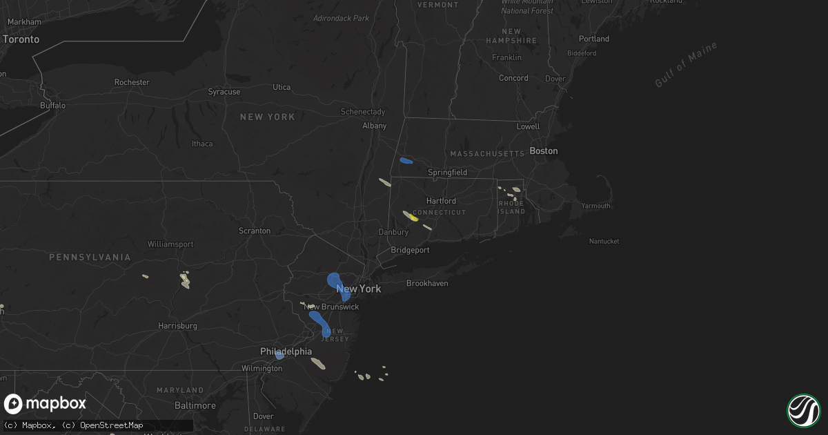
Hail Map on July 25, 2025
Get this storm
July 25 map
$229
one time, instant access
Download today. No call, no setup
Keep the $229
Bought the map and want the full workflow? Apply the entire $229 to a subscription within 7 days. None of it is wasted.
Every map, not just this one
This buys you this map. Subscription and you get every map we run, in the markets you choose from a few cities to whole states to nationwide. Plus real-time alerts the moment a storm fires.
Contact data
Name, contact info, occupancy, even credit band for addresses in the footprint. You go from where it hit to who to call.
Become the source they trust
Unlimited branding weather history reports on demand. You already have the documented answer ready for the property owner, and you are the one who showed up with it.
Property data and RoofTrace estimates
Pull up any address you have got, its value and the exact code rules for that jurisdiction, straight from One Click Code. Then RoofTrace estimates the squares, pitch, and roof value, priced the way you price.
States Impacted by Hail Map on July 25, 2025
Storm reports
Virginia
| Date | Description |
|---|---|
| 07/25/20254:05 PM CDT | Trees and wires blew down near the intersection of montrose street and cherokee avenue. |
| 07/25/20254:00 PM CDT | Trees blew down near the intersection of orange plank road and chancellor way. |
| 07/25/20253:57 PM CDT | Trees blew down on gregory court. |
| 07/25/20253:57 PM CDT | Trees blew down on eastbound va-640 sydenstricker road at briarcliff drive. |
| 07/25/20253:57 PM CDT | A tree blew down onto a house in the 7100 block of rolling forest avenue. |
| 07/25/20252:31 PM CDT | Trees and wires down near the intersection of delaplane grade road and va-710 carr lane. |
| 07/25/20252:22 PM CDT | Tree down near the intersection of gravels road and triple ridge lane. |
West Virginia
| Date | Description |
|---|---|
| 07/25/20251:14 PM CDT | Trees down on adams lane. |
| 07/25/20251:09 PM CDT | Trees down on games ridge road. |
Massachusetts
| Date | Description |
|---|---|
| 07/25/20253:08 PM CDT | In rochester... A tree was down on a fire access road off of negus way. Relayed by amateur radio. |
| 07/25/20253:08 PM CDT | In rochester... A tree was down on north ave. Relayed by amateur radio. |
| 07/25/20252:55 PM CDT | In middleboro... A tree was down on cherry st. Relayed by amateur radio. |
| 07/25/20252:30 PM CDT | In dighton... A tree and wires were down on regional rd. Relayed by amateur radio. |
| 07/25/20252:22 PM CDT | In raynham... Wires were down on goldfinch dr. Relayed by amateur radio. (box |
| 07/25/20252:22 PM CDT | In raynham... A large tree was down on king st. Relayed by amateur radio. |
| 07/25/20252:22 PM CDT | In raynham... Wires were down on goldfinch dr. Relayed by amateur radio. |
| 07/25/20252:10 PM CDT | In plainville... A tree and power lines were down on high st. Relayed by amateur radio. |
| 07/25/20251:50 PM CDT | In medford... A tree was down in a yard on 9th st. Relayed by amateur radio. |
| 07/25/20251:48 PM CDT | In wrentham... A mesonet station gusted to 63 mph. |
| 07/25/20251:40 PM CDT | In belmont... A tree was down on a house on park rd. Relayed by amateur radio. |
| 07/25/20251:40 PM CDT | In belmont... A tree was down on a car with injury reported. Relayed by amateur radio. |
| 07/25/20251:35 PM CDT | In waltham... Wires were down on elm ave. |
| 07/25/20251:35 PM CDT | In newton... A tree was down on wires on fairway dr. Relayed by amateur radio. |
| 07/25/20251:32 PM CDT | In weston... A tree are wires were down on rt 20 at wellesley st. A tree was also down on gail rd. Relayed by amateur radio. |
Minnesota
| Date | Description |
|---|---|
| 07/25/20256:21 AM CDT | A local report indicates 58 MPH wind near Baudette |
Montana
| Date | Description |
|---|---|
| 07/25/20256:47 PM CDT | Asos station klvm livingston. |
| 07/25/20256:36 PM CDT | Rainfall 0.10 or less |
| 07/25/20256:10 PM CDT | 5 miles s of terry. Hail started at 5:10... Storm pretty well passed by 5:30. 0.17 of rain... Smaller hail. Still lightly raining. |
| 07/24/20257:58 PM CDT | A local report indicates 1.25 inch wind near 7 NE Plevna |
| 07/24/20257:30 PM CDT | A local report indicates 1.00 inch wind near 7 NE Plevna |
| 07/24/20257:03 PM CDT | A local report indicates 1.00 inch wind near 2 NNW Ismay |
North Dakota
| Date | Description |
|---|---|
| 07/25/20256:44 PM CDT | Quarter to ping pong ball size hail. |
| 07/25/20252:25 AM CDT | Glenfield nddot mesonet. Radar estimated time. |
| 07/25/20252:15 AM CDT | Public relayed report of wind gusts of 60 to 65 mph. Also had dime sized hail and 1.6 inches of rainfall. |
| 07/25/20252:15 AM CDT | Public relayed report of wind gusts of 60 to 65 mph. Also had dime sized hail and 1.6 inch |
| 07/25/20251:45 AM CDT | Report of a couple of uprooted trees and a fence blown over at a park in carrington. Public report relayed to the nws by broadcast meteorologist. |
| 07/25/20251:45 AM CDT | Photo relayed from social media of multiple tree branches down at the golf course in carrington. Time estimated from radar. |
| 07/25/20251:18 AM CDT | Measured wind gust from private weather station. |
| 07/25/20251:02 AM CDT | Report from mping: ping pong ball |
| 07/25/202512:08 AM CDT | Relayed through social media. Estimated wind speed with pea sized hail and 2.5 inches of rain over about 2 hours. Time estimated from radar. |
| 07/24/202510:30 PM CDT | Ndawn station lefor 10se. Reported at 10 meters... 40 mph at the surface. |
| 07/24/20258:15 PM CDT | Time estimated from radar. |
| 07/24/20258:15 PM CDT | Ndawn stanley 8sw. Recorded at 10 meters... 52 mph at the surface. |
| 07/24/20258:05 PM CDT | Mesonet station 327400 10 sw ross |
| 07/24/20257:39 PM CDT | Ndawn dry fork 1se. Recorded at 10 meters... Peak 63 mph at the surface. |
| 07/24/20257:28 PM CDT | Ndawn hofflund. Reported from 10 meters... 68 mph at the surface. |
| 07/24/20257:11 PM CDT | A local report indicates 1.00 inch wind near Williston |
Oklahoma
| Date | Description |
|---|---|
| 07/25/20256:12 PM CDT | Large maple tree trunk snapped with very strong wind |
Connecticut
| Date | Description |
|---|---|
| 07/25/20252:25 PM CDT | Trees down on power lines and blocking south avenue... Nursery road... And buttery road. |
| 07/25/20252:15 PM CDT | *** 1 inj *** tree down hitting a female on samuel dann way. |
| 07/25/20251:58 PM CDT | Trees and wires down at the intersection of greenhill road and nonnewaug road. Time estimated from radar. |
| 07/25/20251:50 PM CDT | Large tree down near mansion road blocking an entrance to heritage woods. |
| 07/25/20251:48 PM CDT | Tree down on house on greenwood avenue. Power lines to the house also brought down. |
| 07/25/20251:45 PM CDT | Tree down on cooke road. |
| 07/25/20251:43 PM CDT | Large tree branch down on car windshield. |
| 07/25/20251:40 PM CDT | Tree down on primary wires on willow street at calumet street. |
| 07/25/20251:33 PM CDT | Downed tree on echo lake road and porter street in watertown. |
| 07/25/20251:30 PM CDT | Tree limbs down causing a significant power outage reported by eversource. |
| 07/25/20251:28 PM CDT | Tree down on car in the area of 71 long pond road. Person trapped and injured. Time is radar indicated. |
| 07/25/20251:28 PM CDT | Tree down blocking access to valley road and long pond road. Time estimated from radar. |
| 07/25/20251:25 PM CDT | Corrects previous tstm wnd dmg report from 1 sse bethlehem village. Trees and wires down at the intersection of greenhill road and nonnewaug road. Time estimated from r |
| 07/25/20251:20 PM CDT | Tree down on wires on ludlow street at lincoln avenue. |
| 07/25/20251:20 PM CDT | Tree down on wires on crescent street. |
| 07/25/20251:20 PM CDT | Wires down on bristol avenue at peace street. |
| 07/25/20251:05 PM CDT | Tree and wires down at 320 quassapaug road in woodbury... Ct. |
| 07/25/20251:00 PM CDT | Wires pulled off a house at 197 old town farm road. |
| 07/25/202512:58 PM CDT | Social media comment on western ct weather facebook page on trees down along flanders road near bethlehem. |
Pennsylvania
| Date | Description |
|---|---|
| 07/25/20256:25 PM CDT | Multiple trees and communication lines down on and along new berlin highway in franklin township. |
| 07/25/20256:05 PM CDT | Downed tree at island park rd and berger rd. Time estimated by radar. |
| 07/25/20256:02 PM CDT | Powerlines downed causing live wire fire. Time estimated by radar. |
| 07/25/20255:50 PM CDT | Tree and wires down onto springwood road. |
| 07/25/20254:42 PM CDT | Trees down blocking the roadway. |
| 07/25/20254:38 PM CDT | Philadelphia international airport recorded a 54 kt wind gust. |
| 07/25/20254:38 PM CDT | Corrects previous tstm wnd dmg report from philadelphia international airport. Philadelphia international airport recorded a 54 kt wind gust. |
| 07/25/20254:24 PM CDT | *** 1 inj *** updated report from springfield. Trees and wires down. A large tree fell onto an occupied vehicle at bishop avenue and hawarden road. The injured driver w |
| 07/25/20254:24 PM CDT | Trees and wires down. Time estimated from radar. |
| 07/25/20254:19 PM CDT | Tree down blocking one lane of big spring road. |
| 07/25/20254:09 PM CDT | Tree down across railroad track crossing at aquetong rd blocking train and vehicle traffic. Time estimated from radar. |
| 07/25/20253:50 PM CDT | Multiple trees down in green lane. Time estimated from radar. |
| 07/25/20253:32 PM CDT | Trees and wires down. Time estimated from radar. |
| 07/25/20253:30 PM CDT | Trees down. Time estimated from radar. |
| 07/25/20253:27 PM CDT | Trees and wires down. Time estimated from radar. |
| 07/25/20253:25 PM CDT | Trees and wires down. Time estimated from radar. |
| 07/25/20253:22 PM CDT | Treed down blocking one lane of roadway on smith valley rd at boot hill lane. |
| 07/25/20253:20 PM CDT | Multiple trees snapped about part way up their trunks. Photo shared on social media. Time estimated from radar. |
| 07/25/20253:20 PM CDT | Mesonet station ew3190 reading. |
| 07/25/20253:20 PM CDT | Trees on wires. Time estimated from radar. |
| 07/25/20253:20 PM CDT | Trees on wires. Time estimate |
| 07/25/20253:17 PM CDT | Trees and wires down. Time estimated from radar. |
| 07/25/20253:15 PM CDT | Tree on wires with roadway blocked. Time estimated from radar. |
| 07/25/20253:10 PM CDT | Multiple trees and wires down in cornwall borough. |
| 07/25/20253:07 PM CDT | Trees and wires down. Time estimated from radar. |
| 07/25/20253:05 PM CDT | Trees down in centre twp. Time estimated from radar. |
| 07/25/20252:59 PM CDT | Tree down next to weis market. |
| 07/25/20252:58 PM CDT | Multiple trees and wires down in lebanon. |
| 07/25/20252:57 PM CDT | Tree down on south northkill road near the golf course. Time estimated from radar. |
| 07/25/20252:50 PM CDT | Multiple trees and wires down in north lebanon township. |
| 07/25/20252:42 PM CDT | Tree down blocking the roadway on dark hollow road. |
| 07/25/20251:58 PM CDT | Tree down on roadway at the 400 block of south main street in herndon. |
| 07/25/20251:35 PM CDT | Multiple trees down on new lancaster valley road east of milroy. |
| 07/25/20251:15 PM CDT | Tree down on long street near the intersection of cooper street. |
| 07/25/202512:54 PM CDT | Tree down into a house in bellefonte. No injuries reported. |
| 07/24/20257:01 PM CDT | Tree and wires down on forest drive near redners market. |
| 07/24/20257:00 PM CDT | Tree down into a house near the intersection of fearnot road and honey moon trail road. No injuries reported. |
New Jersey
| Date | Description |
|---|---|
| 07/25/20256:07 PM CDT | Damage to powerlines at radio rd and playhouse rd. Time estimated by radar. |
| 07/25/20256:05 PM CDT | Powerlines damaged on cr 539. Time estimated by radar. |
| 07/25/20255:28 PM CDT | Wires |
| 07/25/20255:28 PM CDT | Wires down along route 206 in shamong. Time estimated from radar. |
| 07/25/20255:20 PM CDT | Seaside park nj wxnet. |
| 07/25/20255:04 PM CDT | Wires down in springfield. Tim |
| 07/25/20255:04 PM CDT | Wires down in springfield. Time estimated from radar. |
| 07/25/20255:00 PM CDT | Downed tree on nj 70 near cr 539/whiting new egypt rd; all lanes closed. Time estimated by radar. |
| 07/25/20254:43 PM CDT | Trees and wires down. Time estimated from radar. |
| 07/25/20254:40 PM CDT | Trees and wires down. Time estimated from radar. |
| 07/25/20254:35 PM CDT | Trees and wires down. Time estimated from radar. |
| 07/25/20254:09 PM CDT | Several trees down around delaware township. Time estimated from radar. |
| 07/25/20254:08 PM CDT | Trees down on wires on upper creek road. Time estimated from radar. |
| 07/25/20254:06 PM CDT | Trees and wires down around montgomery township. Time estimated from radar. |
| 07/25/20254:03 PM CDT | Trees and wires down around hillsborough township. Time estimated from radar. |
| 07/25/20253:52 PM CDT | Tree down blocking the roadway in frenchtown. Time estimated from radar. |
| 07/25/20253:37 PM CDT | Trees and wires down with debris in the road way on alfalfa hill road. Time estimated from radar. |
| 07/25/20252:54 PM CDT | 63 mph gust at newark international airport. |
| 07/25/20252:50 PM CDT | Tree down on car on galloping hill road at east clay avenue. The car was not occupied. |
| 07/25/20252:49 PM CDT | Trees and wires down in watchung. Time estimated from radar. |
| 07/25/20252:47 PM CDT | 65 mph wind gust measured by a davis weather station at 10 meters. |
| 07/25/20252:45 PM CDT | Large tree branches down on maple street near west hudson park. |
| 07/25/20252:45 PM CDT | Tree uprooted on crawford terrace. |
| 07/25/20252:43 PM CDT | Live wires down on car on chestnut ave with people trapped inside. |
| 07/25/20252:40 PM CDT | Tree down on wires on west northfield road. |
| 07/25/20252:40 PM CDT | Tree down on house on mount vernon road. |
| 07/25/20252:35 PM CDT | Live wires down on northfield avenue. |
| 07/25/20252:35 PM CDT | 911 call center reporting trees down on both eisenhower parkway and livingston parkway near interstate 280. |
| 07/25/20252:26 PM CDT | Video showing a large tree falling in the backyard of a home. |
| 07/25/20252:21 PM CDT | Wires down along ball road and hawkins road in morris county. Time estimated from radar. |
| 07/25/20252:17 PM CDT | Trees and wires down around parsippany. Time estimated from radar. |
| 07/25/20252:15 PM CDT | Njtansit reported overhead wire issues due to a downed tree on the morris and essex line between the morristown and dover stations. Time estimated by radar. |
| 07/25/20252:13 PM CDT | Trees and wires down. Time estimated from radar. |
| 07/25/20252:09 PM CDT | Trees and wires down along cedar lake road. Time estimated from radar. |
| 07/25/20252:01 PM CDT | Trees and wires down. Time estimated from radar. |
| 07/25/20251:44 PM CDT | Trees down on wires blocking roadway along ridgeway avenue. Time estimated from radar. |
| 07/25/20251:36 PM CDT | Trees and wires down in blairstown twp. Time estimated from radar. |
New York
| Date | Description |
|---|---|
| 07/25/20255:00 PM CDT | Large tree snapped in half and fell onto two parked cars. The cars were not occupied. |
| 07/25/20253:42 PM CDT | Multiple reports of downed trees and wires on wading river road north of the lie. |
| 07/25/20253:38 PM CDT | Numerous trees down at the sundance stables. |
| 07/25/20253:13 PM CDT | Tree down on wires blocking greeley avenue. |
| 07/25/20253:05 PM CDT | Staten island railway service suspended between st. George and grasmere due to a down tree blocking tracks. Reported by mta. |
| 07/25/20253:03 PM CDT | Large tree down on car on fremont avenue in grant city. |
| 07/25/20253:03 PM CDT | Large tree down on wires on prescott avenue at clawson street. |
| 07/25/20253:03 PM CDT | Large tree down on car on tompkins avenue at fingerboard avenue. The car was not occupied. |
| 07/25/20253:03 PM CDT | Tree down blocking kensington avenue. |
| 07/25/20253:03 PM CDT | Uprooted tree blocking mill road at isernia avenue with fire department responding. |
| 07/25/20253:00 PM CDT | Tree down blocking garretson avenue at magnolia avenue with fire department responding. |
| 07/25/20253:00 PM CDT | Large tree down on power lines blocking manor road. |
| 07/25/20253:00 PM CDT | Large tree down on power lines on henry place at burgher avenue. |
| 07/25/20252:55 PM CDT | Mhrn6 mesonet. |
| 07/25/20252:15 PM CDT | Tree down on car with people trapped. |
| 07/25/20252:15 PM CDT | Live wires down on high ridge road at upper shad road. |
| 07/25/20251:23 PM CDT | Two trees down with a car stuck between the two fallen trees. Route 199 near milemarker 22... Area of 4451 route 199 near forest lane. Time is estimated by radar. |
| 07/25/20251:18 PM CDT | Tree on wires on bean river road in pine plains. |
| 07/25/20251:02 PM CDT | Tree and wires on near road in the town of gallatin. Time estimated from radar. |
Illinois
| Date | Description |
|---|---|
| 07/24/202511:47 PM CDT | Delayed report of a 8-10 inch tree snapped at base with time estimated from radar. |
| 07/24/202511:30 PM CDT | Large limbs down. |
| 07/24/202511:07 PM CDT | Trained spotter estimated 60 mph wind gust. |
| 07/24/202510:59 PM CDT | Delayed report. Six inch tree limbs down across kickapoo creek park and surrounding area. |
| 07/24/202510:59 PM CDT | Delayed report. Six inch tree limbs down acro |
| 07/24/202510:33 PM CDT | Branches down. Time estimated from radar. |
Kansas
| Date | Description |
|---|---|
| 07/24/20258:30 PM CDT | Delayed report - 2-inch tree limb down. |
Rhode Island
| Date | Description |
|---|---|
| 07/25/20252:15 PM CDT | In providence... A tree was down on prairie ave. Relayed by amateur radio. |
| 07/25/20252:15 PM CDT | In providence... A tree was down on wallace st. Relayed by amateur radio. |
| 07/25/20252:10 PM CDT | In north providence... A tree was down on wires on randall rd. Relayed by amateur radio. |
| 07/25/20252:05 PM CDT | In pawtucket... A tree was down on a house. Relayed by amateur radio. |
Ohio
| Date | Description |
|---|---|
| 07/25/20254:25 PM CDT | Tree down. |
| 07/25/20254:20 PM CDT | Large tree knocked into window of home and caught fire near the intersection of west national rd and old mill rd. Time est from radar. |
| 07/25/20253:29 PM CDT | Tree down. |
| 07/25/20253:24 PM CDT | Multiple reports of power lines and trees down in area of main st in sidney oh. |
| 07/25/20253:24 PM CDT | Multiple reports of power lines and trees do |
| 07/25/20253:16 PM CDT | Tree down. |
Idaho
| Date | Description |
|---|---|
| 07/24/20257:51 PM CDT | Mesonet station krci1 kriley creek raws. |
Cities Impacted by Hail Map on July 25, 2025
- South Lee, MA
- Stockbridge, MA
- Great Barrington, MA
- Monterey, MA
- Tyringham, MA
- Lee, MA
- Otis, MA
- Moundsville, WV
- Powhatan Point, OH
- Proctor, WV
- Clarington, OH
- Woodbury, CT
- Middlebury, CT
- Watertown, CT
- Waterbury, CT
- Glen Easton, WV
- Bethlehem, CT
- Washington, CT
- Wind Ridge, PA
- Aleppo, PA
- Cameron, WV
- Pine Plains, NY
- Coburn, PA
- Aaronsburg, PA
- Woodward, PA
- Ancramdale, NY
- Millerton, NY
- Ancram, NY
- Millmont, PA
- Milroy, PA
- Cheshire, CT
- Hamden, CT
- Prospect, CT
- Chepachet, RI
- Wallingford, CT
- North Haven, CT
- Lincoln, RI
- Cumberland, RI
- Providence, RI
- Smithfield, RI
- Bethany, CT
- Dornsife, PA
- Parsippany, NJ
- Mountain Lakes, NJ
- Mount Tabor, NJ
- Morristown, NJ
- Cedar Knolls, NJ
- Whippany, NJ
- Montville, NJ
- Lake Hiawatha, NJ
- Boonton, NJ
- Morris Plains, NJ
- Denville, NJ
- Florham Park, NJ
- Madison, NJ
- East Hanover, NJ
- Chatham, NJ
- Green Village, NJ
- Summit, NJ
- Short Hills, NJ
- Livingston, NJ
- Pine Brook, NJ
- Fairfield, NJ
- Roseland, NJ
- West Orange, NJ
- Essex Fells, NJ
- Caldwell, NJ
- Delaplane, VA
- Markham, VA
- Millburn, NJ
- Springfield, NJ
- Newark, NJ
- Union, NJ
- Vauxhall, NJ
- Maplewood, NJ
- South Orange, NJ
- Irvington, NJ
- Kenilworth, NJ
- Roselle Park, NJ
- Elizabeth, NJ
- Roselle, NJ
- Hillside, NJ
- Cranford, NJ
- Linden, NJ
- Carteret, NJ
- Rahway, NJ
- Avenel, NJ
- Port Reading, NJ
- Murrysville, PA
- Pittsburgh, PA
- New Kensington, PA
- Hagerstown, IN
- Cambridge City, IN
- North Scituate, RI
- Johnston, RI
- Cranston, RI
- Jackson Center, OH
- Huntsville, OH
- Lakeview, OH
- Sewaren, NJ
- Russells Point, OH
- Apollo, PA
- Elizabethport, NJ
- Staten Island, NY
- Bayonne, NJ
- Arcanum, OH
- Bell, FL
- Bradford, OH
- Versailles, OH
- Houston, OH
- Covington, OH
- Russia, OH
- Rixeyville, VA
- Amissville, VA
- Celina, OH
- Sidney, OH
- Piqua, OH
- Dryden, TX
- Cohagen, MT
- Osawatomie, KS
- Paola, KS
- Saint Marys, OH
- Angela, MT
- Fort Stockton, TX
- Madison, KS
- Logansport, IN
- Richwood, OH
- Marysville, OH
- Flemington, NJ
- Skillman, NJ
- Belle Mead, NJ
- Rocky Hill, NJ
- Hopewell, NJ
- Princeton, NJ
- Plainsboro, NJ
- Pennington, NJ
- Monmouth Junction, NJ
- Kingston, NJ
- Princeton Junction, NJ
- Hillsborough, NJ
- Cranbury, NJ
- Brockway, MT
- Neshanic Station, NJ
- Waverly, KS
- Williamsburg, KS
- Allentown, NJ
- Robbinsville, NJ
- Hightstown, NJ
- Cream Ridge, NJ
- Windsor, NJ
- Millstone Township, NJ
- Monroe Township, NJ
- Roosevelt, NJ
- Culbertson, MT
- Blairsden Graeagle, CA
- Kinsey, MT
- Louisburg, KS
- Peru, IN
- Wabash, IN
- Clio, CA
- Lansdowne, PA
- Holmes, PA
- Norwood, PA
- Springfield, PA
- Folcroft, PA
- Drexel Hill, PA
- Glenolden, PA
- Essington, PA
- Sharon Hill, PA
- Darby, PA
- Philadelphia, PA
- Clifton Heights, PA
- Prospect Park, PA
- Folsom, PA
- Ridley Park, PA
- Morton, PA
- Broxton, GA
- Vincentown, NJ
- Terry, MT
- Dagmar, MT
- Termo, CA
- Canyon Dam, CA
- Twain, CA
- Chatsworth, NJ
- Raton, NM
- Heath, OH
- Madeline, CA
- Cedarville, CA
- Bainville, MT
- Greenville, CA
- Jal, NM
- Cimarron, NM
- Williston, ND
- Waukomis, OK
- Enid, OK
- Alturas, CA
- Belden, CA
- Susanville, CA
- Eureka, KS
- Ozona, TX
- Fairview, MT
- Fallon, MT
- Carnelian Bay, CA
- Truckee, CA
- Canon City, CO
- Sunbury, PA
- Shamokin Dam, PA
- Selinsgrove, PA
- Northumberland, PA
- Medford, OK
- Rebuck, PA
- Brooksville, FL
- Paxinos, PA
- Ismay, MT
- Platina, CA
- Shamokin, PA
- Trevorton, PA
- Vernon, TX
- Epping, ND
- Lookout, CA
- Douglas City, CA
- Fall River Mills, CA
- Trenton, ND
- Matador, TX
- Flomot, TX
- Grenville, NM
- Livermore, CO
- Plevna, MT
- Baker, MT
- Ray, ND
- White Earth, ND
- Tioga, ND
- Caldwell, KS
- Sedalia, CO
- Elizabeth, CO
- Mayfield, KS
- Kiowa, CO
- Mulvane, KS
- Belle Plaine, KS
- Milan, KS
- Wellington, KS
- Winfield, PA
- Stanley, ND
- New Town, ND
- Ross, ND
- Watford City, ND
- Marmarth, ND
- Hat Creek, CA
- Cassel, CA
- Teague, TX
- Argonia, KS
- Trinity Center, CA
- Lewiston, CA
- Conway Springs, KS
- Bennett, CO
- Clearwater, KS
- Rhame, ND
- Palermo, ND
- Keene, ND
- Parshall, ND
- Wichita, KS
- Goddard, KS
- El Dorado, KS
- Burns, KS
- Strasburg, CO
- Potwin, KS
- Maize, KS
- McIntire, IA
- Stacyville, IA
- Bowman, ND
- Berthold, ND
- Plaza, ND
- Carpio, ND
- Donnybrook, ND
- Valley Center, KS
- Groesbeck, TX
- Colwich, KS
- Towanda, KS
- Streetman, TX
- Farmersville, IL
- Cassoday, KS
- Powers Lake, ND
- Economy, IN
- Greens Fork, IN
- Virden, IL
- Glenarm, IL
- Springfield, IL
- Medora, ND
- Riverton, IL
- Lansford, ND
- Dickinson, ND
- Lefor, ND
- New England, ND
- Regent, ND
- Taylor, ND
- Gladstone, ND
- Richardton, ND
- Mott, ND
- Hebron, ND
- Glen Ullin, ND
- New Leipzig, ND
- Elgin, ND
- Mason City, IL
- Middletown, IL
- Greenview, IL
- Souris, ND
- Pleasant Plains, IL
- Dawson, IL
- Girard, IL
- Sherman, IL
- Williamsville, IL
- Alexander, IL
- New Berlin, IL
- New Salem, ND
- Carson, ND
- Almont, ND
- Granville, ND
- Buffalo, IL
- Towner, ND
- Washburn, ND
- Lincoln, IL
- Elkhart, IL
- New Holland, IL
- Mercer, ND
- Underwood, ND
- Balfour, ND
- Hazen, ND
- Beulah, ND
- Stanton, ND
- Center, ND
- Flasher, ND
- Mcclusky, ND
- Weatherford, OK
- Rugby, ND
- Mount Sterling, IL
- Wapella, IL
- Lawndale, IL
- Atlanta, IL
- Goodrich, ND
- McLean, IL
- Willow City, ND
- Shirley, IL
- Bismarck, ND
- Mandan, ND
- Rolette, ND
- Bloomington, IL
- Downs, IL
- Towanda, IL
- Lexington, IL
- Delavan, IL
- Ellsworth, IL
- Emden, IL
- Minier, IL
- Heyworth, IL
- Beason, IL
- Hartsburg, IL
- Danvers, IL
- Hudson, IL
- Kenney, IL
- Mount Pulaski, IL
- Clinton, IL
- Normal, IL
- Stanford, IL
- Armington, IL
- Le Roy, IL
- Cooksville, IL
- Chestnut, IL
- Waynesville, IL
- Arrowsmith, IL
- Colfax, IL
- Baldwin, ND
- Mylo, ND
- Wolford, ND
- Hurdsfield, ND
- Denhoff, ND
- Anchor, IL
- Cropsey, IL
- Knox, ND
- Wing, ND
- Sibley, IL
- Bisbee, ND
- Perth, ND
- Max, ND
- Chaseley, ND
- Harvey, ND
- Rocklake, ND
- Minot, ND
- Sawyer, ND
- Benedict, ND
- Bowdon, ND
- Norwich, ND
- Pettibone, ND
- Munich, ND
- Robinson, ND
- Chandlerville, IL
- Fessenden, ND
- Langdon, ND
- Woodworth, ND
- Sykeston, ND
- Velva, ND
- Starkweather, ND
- York, ND
- Cathay, ND
- Egeland, ND
- New Rockford, ND
- Karlsruhe, ND
- Carrington, ND
- Pingree, ND
- Alexandria, MO
- Canton, MO
- Warsaw, IL
- Drake, ND
- Mchenry, ND
- Glenfield, ND
- Kensal, ND
- Jamestown, ND
- Buchanan, ND
- Athens, IL
- Montpelier, ND
- Binford, ND
- Butte, ND
- Anamoose, ND
- Park River, ND
- Courtenay, ND
- Pekin, ND
- Mcville, ND
- Yarmouth, IA
- Ypsilanti, ND
- Arbela, MO
- Princeton, MO
- Wimbledon, ND
- Cooperstown, ND
- Luray, MO
- Wyaconda, MO
- Spiritwood, ND
- Rogers, ND
- Dazey, ND
- Grace City, ND
- Sutton, ND
- Hannaford, ND
- Luverne, ND
- Marion, ND
- Sanborn, ND
- Litchville, ND
- Valley City, ND
- Hope, ND
- Page, ND
- Buffalo, ND
- Tower City, ND
- Oriska, ND
- Fingal, ND
- Kathryn, ND
- Ayr, ND
- Absaraka, ND
- Amenia, ND
- Wheatland, ND
- Enderlin, ND
- Mapleton, ND
- Arthur, ND
- Davenport, ND
- Casselton, ND
- Leonard, ND
- Horace, ND
- Fargo, ND
- West Fargo, ND
- Thornville, OH
- Barnesville, MN
- Hawley, MN
- Pelican Rapids, MN
- Burlington, ND