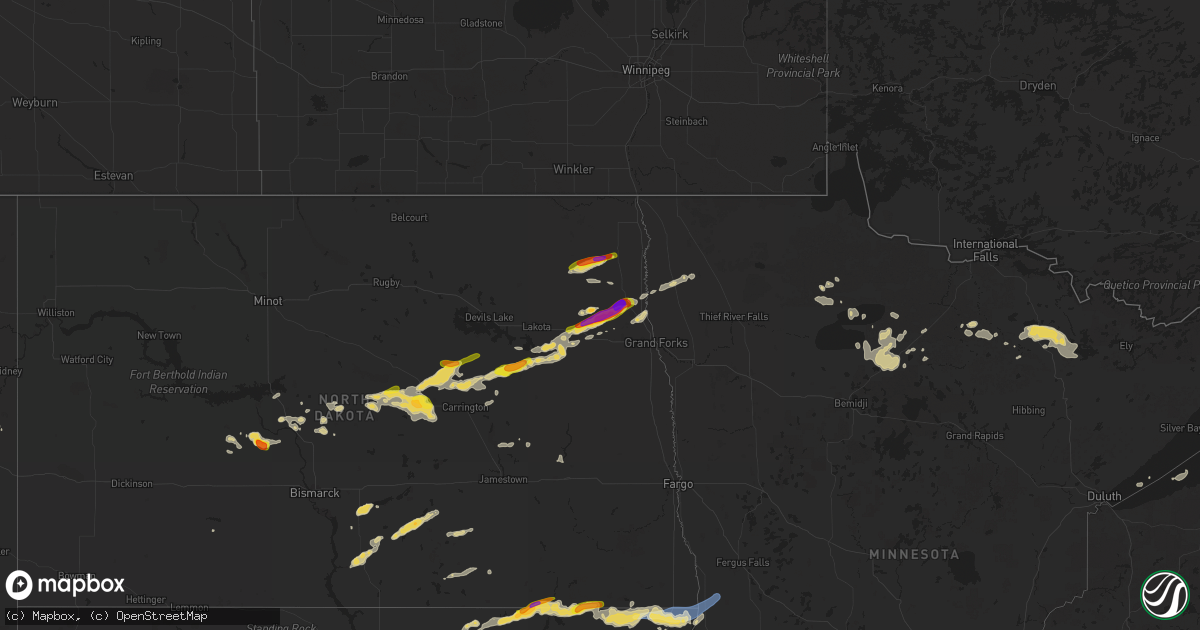
Hail Map on July 14, 2025
Get this storm
July 14 map
$229
one time, instant access
Download today. No call, no setup
Keep the $229
Bought the map and want the full workflow? Apply the entire $229 to a subscription within 7 days. None of it is wasted.
Every map, not just this one
This buys you this map. Subscription and you get every map we run, in the markets you choose from a few cities to whole states to nationwide. Plus real-time alerts the moment a storm fires.
Contact data
Name, contact info, occupancy, even credit band for addresses in the footprint. You go from where it hit to who to call.
Become the source they trust
Unlimited branding weather history reports on demand. You already have the documented answer ready for the property owner, and you are the one who showed up with it.
Property data and RoofTrace estimates
Pull up any address you have got, its value and the exact code rules for that jurisdiction, straight from One Click Code. Then RoofTrace estimates the squares, pitch, and roof value, priced the way you price.
States Impacted by Hail Map on July 14, 2025
Storm reports
Mississippi
| Date | Description |
|---|---|
| 07/14/20253:15 PM CDT | Trees were blown down on sylvarena road. |
Utah
| Date | Description |
|---|---|
| 07/14/20256:50 PM CDT | Measured at the sr 30 at curlew udot rwis site. |
| 07/14/20255:37 PM CDT | Measured at the lucin upr site. |
Wyoming
| Date | Description |
|---|---|
| 07/14/20253:15 PM CDT | A local report indicates 77 MPH wind near 12 SSE Horse Creek |
Pennsylvania
| Date | Description |
|---|---|
| 07/14/20254:12 PM CDT | Power lines down. |
| 07/14/20254:12 PM CDT | Tree down blocking the road at oriole ln. |
Virginia
| Date | Description |
|---|---|
| 07/14/20255:08 PM CDT | Tree downed by thunderstorm winds at the intersection of howardsville road and mulberry grove road. |
| 07/13/202510:34 PM CDT | Vdot reporting exit 52 at bank st is closed. |
| 07/13/20259:20 PM CDT | Trees downed on old church rd near tunstall. |
| 07/13/20259:16 PM CDT | Tree down at the intersection of chatham road and mountain valley road. |
| 07/13/20259:16 PM CDT | One tree down at old eanes store loop. |
| 07/13/20258:43 PM CDT | Tree down covering part of road near the intersection of windy ridge rd and virgil h goode hwy. |
| 07/13/20258:43 PM CDT | Tree downed by thunderstorm winds on the southbound side and blocking the entire lane of virgil h goode highway.... One mile north of fishburn mountain road. |
Maine
| Date | Description |
|---|---|
| 07/14/20253:49 PM CDT | Trees down and pole snapped near ashland high school closing road. |
| 07/14/20253:26 PM CDT | Corrects timing of previous tstm wnd dmg report from 1 ese ashland. Trees down and pole snapped near ashland high school closing road. |
| 07/14/20253:25 PM CDT | Large tree uprooted. |
| 07/14/20253:19 PM CDT | Tree down across the road. |
| 07/14/20253:19 PM CDT | Quarter size hail in ashland. |
Idaho
| Date | Description |
|---|---|
| 07/14/20255:15 PM CDT | Mesonet station itdd3 d6 junction summit id-22/id-33. |
| 07/14/20255:10 PM CDT | Mesonet station bas base of howe peak. |
| 07/14/20254:30 PM CDT | Pacificorp reno gulch. |
| 07/14/20254:30 PM CDT | Mesonet station pc374 reno gulch. |
Nebraska
| Date | Description |
|---|---|
| 07/13/20258:54 PM CDT | Corrects previous wnd gst report from 2 ssw sidney. Asos station ksny sidney airport. |
North Dakota
| Date | Description |
|---|---|
| 07/14/20251:05 AM CDT | (fg |
| 07/14/20251:05 AM CDT | A local report indicates 1.00 inch wind near Edinburg |
| 07/14/20251:05 AM CDT | A local report indicates 1.25 inch wind near Hoople |
| 07/14/20251:00 AM CDT | A local report indicates 1.00 inch wind near Park River |
| 07/14/202512:25 AM CDT | A local report indicates 1.00 inch wind near Ardoch |
| 07/14/202512:24 AM CDT | Relayed via broadcast media. |
| 07/14/202512:08 AM CDT | In town. |
| 07/14/202512:05 AM CDT | In town. |
| 07/14/202512:00 AM CDT | Delayed report... Corn fields damaged time estimated via radar. |
| 07/13/202510:55 PM CDT | A few trees down in town. One evergreen uprooted with a couple of box elder maples snapped. Pea size hail with a few stones maybe a little bit larger. |
| 07/13/202510:52 PM CDT | Report from mping: quarter |
| 07/13/202510:46 PM CDT | Crop damage was reported... But details were scarce. |
| 07/13/202510:30 PM CDT | Pea... Marble... And some golf ball size hail. Video relayed via broadcast media. Time estimated from radar. |
South Carolina
| Date | Description |
|---|---|
| 07/14/20254:37 PM CDT | Bamberg county dispatch reported trees down on a powerline in denmark... Sc. Time estimated by radar. |
Colorado
| Date | Description |
|---|---|
| 07/14/20255:53 PM CDT | Location estimated. |
| 07/14/20255:30 PM CDT | A local report indicates 1.00 inch wind near Calhan |
| 07/14/20255:10 PM CDT | A local report indicates 63 MPH wind near 2 ESE Kiowa |
| 07/14/20255:10 PM CDT | Corrects previous tstm wnd gst report from 2 ese kiowa. |
| 07/14/20255:05 PM CDT | A local report indicates 1.00 inch wind near 8 E Kiowa |
| 07/14/20254:15 PM CDT | A local report indicates 67 MPH wind near 10 E Arapahoe Park |
| 07/14/20253:33 PM CDT | Lasted about 90 seconds. Damage to a commercial building. |
New Mexico
| Date | Description |
|---|---|
| 07/13/20257:00 PM CDT | Corrected report. Mesonet station nm012 i-25 @ rowe |
South Dakota
| Date | Description |
|---|---|
| 07/14/20256:55 PM CDT | A local report indicates 60 MPH wind near Sharps Corner |
| 07/14/20256:40 PM CDT | A local report indicates 60 MPH wind near 2 NE Kadoka |
| 07/14/20256:31 PM CDT | A local report indicates 62 MPH wind near 12 E Oelrichs |
| 07/14/20256:20 PM CDT | A local report indicates 58 MPH wind near 10 ESE Oelrichs |
| 07/14/20255:55 PM CDT | A local report indicates 68 MPH wind near 3 E Philip |
| 07/14/20255:51 PM CDT | A local report indicates 93 MPH wind near 4 E Cactus Flat |
| 07/14/20255:46 PM CDT | A local report indicates 88 MPH wind near 4 E Cactus Flat |
| 07/14/20255:46 PM CDT | Semi blown over on i-90 near mm146. |
| 07/14/20255:40 PM CDT | A local report indicates 71 MPH wind near 8 S Wall |
| 07/14/20255:20 PM CDT | A local report indicates 60 MPH wind near Wall |
| 07/14/20255:10 PM CDT | A local report indicates 60 MPH wind near Wall |
| 07/14/20252:00 AM CDT | Scattered crop damage. |
| 07/14/20251:36 AM CDT | Mesonet station 58 victor |
| 07/14/20251:14 AM CDT | Report that calf shelters were thrown by the wind into fence. |
| 07/14/20251:14 AM CDT | Report that calf shelters were thrown |
| 07/13/202511:50 PM CDT | Fertilizer bin tipped over by wind... Crop damage from wind and hail. |
| 07/13/20259:50 PM CDT | A local report indicates 61 MPH wind near 1 NE Midland |
| 07/13/20259:45 PM CDT | A local report indicates 67 MPH wind near 3 ENE Midland |
| 07/13/20259:35 PM CDT | A local report indicates 69 MPH wind near 1 NE Midland |
| 07/13/20259:35 PM CDT | A local report indicates 59 MPH wind near 7 WSW Hoover |
| 07/13/20259:25 PM CDT | Mesonet station 13 vivian |
| 07/13/20259:25 PM CDT | A local report indicates 59 MPH wind near 7 WSW Hoover |
| 07/13/20259:25 PM CDT | A local report indicates 73 MPH wind near 1 NE Midland |
| 07/13/20259:20 PM CDT | A local report indicates 62 MPH wind near 1 NE Midland |
| 07/13/20259:20 PM CDT | A local report indicates 58 MPH wind near 7 WSW Hoover |
| 07/13/20259:02 PM CDT | A local report indicates 63 MPH wind near 3 ENE Midland |
| 07/13/20259:00 PM CDT | Estimates 50-60 mph wind on 180th street 5 miles west of hwy 47. |
| 07/13/20258:51 PM CDT | Flom weatherlink station. |
| 07/13/20258:51 PM CDT | Mesonet station 293 timber lake |
| 07/13/20258:51 PM CDT | Mesonet station 293 timbe |
| 07/13/20258:45 PM CDT | Mesonet station tims2 timber lake |
| 07/13/20258:45 PM CDT | A local report indicates 63 MPH wind near 4 E Cactus Flat |
| 07/13/20258:45 PM CDT | A local report indicates 71 MPH wind near 1 NE Midland |
| 07/13/20258:40 PM CDT | Mesonet station 178 trail city |
| 07/13/20258:30 PM CDT | Power lines down blocking the road. Estimated wind near 100 mph. |
| 07/13/20258:11 PM CDT | Asos station kpir pierre muni ap. Trained spotter also reports trees down in pierre. |
| 07/13/20258:07 PM CDT | Asos station kpir pierre muni ap. Initial gust of 82 mph at asos... Which is asos time of peak wind. Another gust of 82 mph occurred at 811 pm cdt. |
| 07/13/20257:50 PM CDT | Penny to quarter sized hail fell. Estimated time from radar. |
| 07/13/20257:50 PM CDT | Mesonet station onms2 onida 13wsw |
| 07/13/20257:26 PM CDT | A local report indicates 66 MPH wind near 9 ENE Belvidere |
| 07/13/20257:00 PM CDT | A local report indicates 1.00 inch wind near 5 WNW Mission Ridge |
Florida
| Date | Description |
|---|---|
| 07/14/20254:24 PM CDT | Dot traffic cameras show that trees have fallen onto southbound lanes of i-75 at exit 293. Time estimated from radar. |
| 07/14/20254:12 PM CDT | A local report indicates 0 MPH wind near 3 WNW Ridge Manor |
| 07/14/20253:41 PM CDT | Ochlockonee bay ambient station gusted to 60 mph. |
| 07/14/20253:06 PM CDT | Storm chaser relayed photo and video on social media showing trees down along us-441. Time est. Off radar and max wind gust of 36 mph at kgnv at 4:07pm. |
| 07/14/20252:28 PM CDT | Trees and powerlines reported down in the town of florahome. Time of event based on radar data. |
| 07/14/20251:45 PM CDT | A video was relayed of a tree down on powerlines along leonard c taylor pkwy. Time was estimated by radar. Nearby gust of 63 mph was measured by a personal weather stat |
| 07/14/20251:44 PM CDT | Personnel weather station reynolds park - kflgreen22 reported wind gust of 63 mph. |
Georgia
| Date | Description |
|---|---|
| 07/14/20255:06 PM CDT | Social media reports a tree down along ceasar avenue. Time estimated by radar. At the same time... The power was out at darwelong road. |
| 07/14/20254:51 PM CDT | Liberty county warning point reported a large limb in roadway at olmstead drive and north main street and power lines down on sabreena circle. |
| 07/14/20252:30 PM CDT | Trees down on highway 121 between brannen road and pond view road. Time estimated by radar. |
New Hampshire
| Date | Description |
|---|---|
| 07/14/20255:41 PM CDT | Multiple reports of trees and wires down on north side of newfound lake. Numerous reports of power outages |
| 07/14/20252:35 PM CDT | Stratford hollow fire dept employee reported 4 downed trees and numerous large branches along the daniel webster hwy between mt view rd and percy rd; 1 tree was partial |
Montana
| Date | Description |
|---|---|
| 07/13/20259:00 PM CDT | Mesonet station mtlwm 2.0 sw livingston |
Maryland
| Date | Description |
|---|---|
| 07/14/20255:32 PM CDT | Large tree branch has fallen on a garage and part of the house connected to it at 2414 blooming way |
New York
| Date | Description |
|---|---|
| 07/14/20252:35 PM CDT | Trees down blocking right lane of i 87 northbound. Time estimated by radar. |
Texas
| Date | Description |
|---|---|
| 07/14/20256:14 PM CDT | Public reported power pole leaning after strong winds moved through the area. Wooden fence also normal to the wind direction... Exhibited no visible damage. |
| 07/14/20256:10 PM CDT | West texas mesonet report. |
| 07/14/20255:24 PM CDT | Accumulating hail up to a depth of two inches... With quarter size hail measured within the swath. Vegetation shredded. |
Cities Impacted by Hail Map on July 14, 2025
- Okeechobee, FL
- North Augusta, SC
- Mescalero, NM
- Douglas, WY
- Wyalusing, PA
- Florahome, FL
- Happy, TX
- Tulia, TX
- Green Cove Springs, FL
- Saint Johns, FL
- Saint Augustine, FL
- Alamogordo, NM
- Metter, GA
- Lockney, TX
- Columbia, PA
- Mayhill, NM
- Fort McCoy, FL
- Kissimmee, FL
- Davenport, FL
- Cloudcroft, NM
- Florissant, CO
- Ralls, TX
- Clinton, LA
- Floydada, TX
- Saint George, GA
- Ocala, FL
- Claude, TX
- Bethune, SC
- Ashland, ME
- Fort Meade, FL
- White Oak, GA
- Waynesville, GA
- Sopchoppy, FL
- Crosbyton, TX
- Cotopaxi, CO
- Kress, TX
- Rapid City, SD
- Lance Creek, WY
- Brooklet, GA
- Gonzales, TX
- Lorenzo, TX
- Guyton, GA
- Box Elder, SD
- Garnett, SC
- Kiowa, CO
- Pembroke, GA
- Fort Stewart, GA
- Ludowici, GA
- Webster, FL
- Slaton, TX
- Brooksville, FL
- Wilson, TX
- Wall, SD
- Quinn, SD
- Floral City, FL
- Inverness, FL
- Hinesville, GA
- Edgemont, SD
- Westcliffe, CO
- Plainview, TX
- Black Hawk, SD
- Ramah, CO
- Corona, NM
- Brownfield, TX
- Dade City, FL
- Lubbock, TX
- Agate, CO
- Bennett, CO
- Elbert, CO
- Harrisburg, NE
- Inglis, FL
- Scenic, SD
- Calhan, CO
- Byers, CO
- Custer, SD
- Fairburn, SD
- Pine Ridge, SD
- Kadoka, SD
- Interior, SD
- Blackville, SC
- Hot Springs, SD
- Cedar Key, FL
- Oelrichs, SD
- Chiefland, FL
- Wolfforth, TX
- Burton, TX
- Beulah, CO
- Pueblo, CO
- Carpenter, WY
- Cheyenne, WY
- Grover, CO
- Levelland, TX
- Ropesville, TX
- Bryans Road, MD
- Hale Center, TX
- Dimmitt, TX
- Yeso, NM
- Denmark, SC
- Philip, SD
- Ault, CO
- San Antonio, FL
- Wesley Chapel, FL
- Land O'Lakes, FL
- Spring Hill, FL
- Smithville, TX
- Ledbetter, TX
- Wasta, SD
- Burns, WY
- Oral, SD
- Smithwick, SD
- Simla, CO
- Old Town, FL
- Lutz, FL
- Kyle, SD
- Wanblee, SD
- Yoder, CO
- New Underwood, SD
- Owanka, SD
- Olar, SC
- Clovis, NM
- Houston, TX
- Earth, TX
- Bamberg, SC
- Terreton, ID
- Monroe, NC
- Elizabeth, CO
- Colorado Springs, CO
- Pine Bluffs, WY
- Hermosa, SD
- Allen, SD
- Porcupine, SD
- Hill City, SD
- Lead, SD
- Albin, WY
- Cross City, FL
- Briggsdale, CO
- Tampa, FL
- Fort Pierre, SD
- Gillette, WY
- Harrison, NE
- Hayes, SD
- Eagle Butte, SD
- Odonnell, TX
- Mitchell, NE
- La Plata, MD
- Ribera, NM
- Spring, TX
- Lamesa, TX
- Crawford, NE
- Faulkner, MD
- Bel Alton, MD
- Newburg, MD
- Midland, SD
- Tahoka, TX
- Muleshoe, TX
- Martin, SD
- Long Valley, SD
- White River, SD
- Norris, SD
- Belvidere, SD
- Lyman, NE
- Gering, NE
- Mayo, FL
- Spencer, ID
- Cannon Afb, NM
- Chaptico, MD
- Avenue, MD
- Bushwood, MD
- Marshville, NC
- Charlotte Hall, MD
- Mechanicsville, MD
- Pierre, SD
- Las Vegas, NM
- Marsland, NE
- Oakboro, NC
- Onida, SD
- Isabel, SD
- Timber Lake, SD
- Saint Anthony, ID
- Glencross, SD
- Fowler, CO
- Wakpala, SD
- Indian Head, MD
- Marbury, MD
- Blunt, SD
- Harrold, SD
- Trail City, SD
- McLaughlin, SD
- Whitehorse, SD
- Okaton, SD
- Cadwell, GA
- Gettysburg, SD
- Bushnell, NE
- Eaton, CO
- Troy, NC
- Saint Johns, AZ
- New Raymer, CO
- Padroni, CO
- Kimball, NE
- Dix, NE
- Peetz, CO
- Sidney, NE
- Termo, CA
- Ridgeview, SD
- Seneca, SD
- Faulkton, SD
- Belle Fourche, SD
- Newell, SD
- Highmore, SD
- Holabird, SD
- Ree Heights, SD
- Miller, SD
- Kaycee, WY
- Vivian, SD
- Thonotosassa, FL
- Galeton, CO
- Big Sandy, MT
- Box Elder, MT
- Buffalo, SD
- Frederick, SD
- Hurdsfield, ND
- Chaseley, ND
- Harvey, ND
- Ellendale, ND
- Oakes, ND
- Leola, SD
- Estill, SC
- Clements, MD
- Story, WY
- Fort Benton, MT
- Sheridan, WY
- Linton, ND
- Lehr, ND
- Amelia Court House, VA
- Bowdon, ND
- Fessenden, ND
- New Rockford, ND
- Warwick, ND
- Tolna, ND
- Mchenry, ND
- Sykeston, ND
- Reva, SD
- Loma, MT
- Kintyre, ND
- Moffit, ND
- Havre, MT
- Fredonia, ND
- Braddock, ND
- Hazelton, ND
- Buffalo, WY
- Pekin, ND
- Britton, SD
- Napoleon, ND
- Prairie City, SD
- Hecla, SD
- Sheyenne, ND
- Petersburg, ND
- Cogswell, ND
- Niagara, ND
- Gackle, ND
- Goodrich, ND
- Cathay, ND
- Stanton, ND
- New Salem, ND
- Center, ND
- Forman, ND
- Inkster, ND
- Lisco, NE
- Roundup, MT
- Mercer, ND
- Washburn, ND
- Carrington, ND
- Kulm, ND
- Streeter, ND
- Tappen, ND
- Mcclusky, ND
- Forest River, ND
- Gilby, ND
- Havana, ND
- Edgeley, ND
- Mcville, ND
- Lakota, ND
- Michigan, ND
- Underwood, ND
- Jud, ND
- Chinook, MT
- Minto, ND
- Aneta, ND
- Fordville, ND
- Hazen, ND
- Beulah, ND
- Larimore, ND
- Grace City, ND
- Wilton, ND
- Buchanan, ND
- Courtenay, ND
- Edinburg, ND
- Hoople, ND
- Crystal, ND
- Argyle, MN
- Veblen, SD
- Wimbledon, ND
- Park River, ND
- Claire City, SD
- New Effington, SD
- Saint Thomas, ND
- Forest Grove, MT
- Lidgerwood, ND
- Rogers, ND
- Valley City, ND
- Circle, MT
- Pisek, ND
- Stephen, MN
- Strandquist, MN
- Sisseton, SD
- Oslo, MN
- Grygla, MN
- Hankinson, ND
- Manvel, ND
- Mekinock, ND
- Rosholt, SD
- Fairmount, ND
- Wheaton, MN
- Lake City, SD
- Tintah, MN
- Nashua, MN
- Campbell, MN
- Kelliher, MN
- Big Falls, MN
- Bloomfield, MT
- Lindsay, MT
- Hines, MN
- Blackduck, MN
- Northome, MN
- Orr, MN
- Glendive, MT
- Mizpah, MN
- Wibaux, MT
- San Jose, NM
- Pecos, NM
- Cook, MN
- Wirt, MN
- Tower, MN
- Coleharbor, ND
- Michigamme, MI
- Snowville, UT
- Malad City, ID
- Holbrook, ID
- Downey, ID
- Mccammon, ID
- Lava Hot Springs, ID
- Arimo, ID
- Grace, ID
- Ririe, ID
- Swan Valley, ID