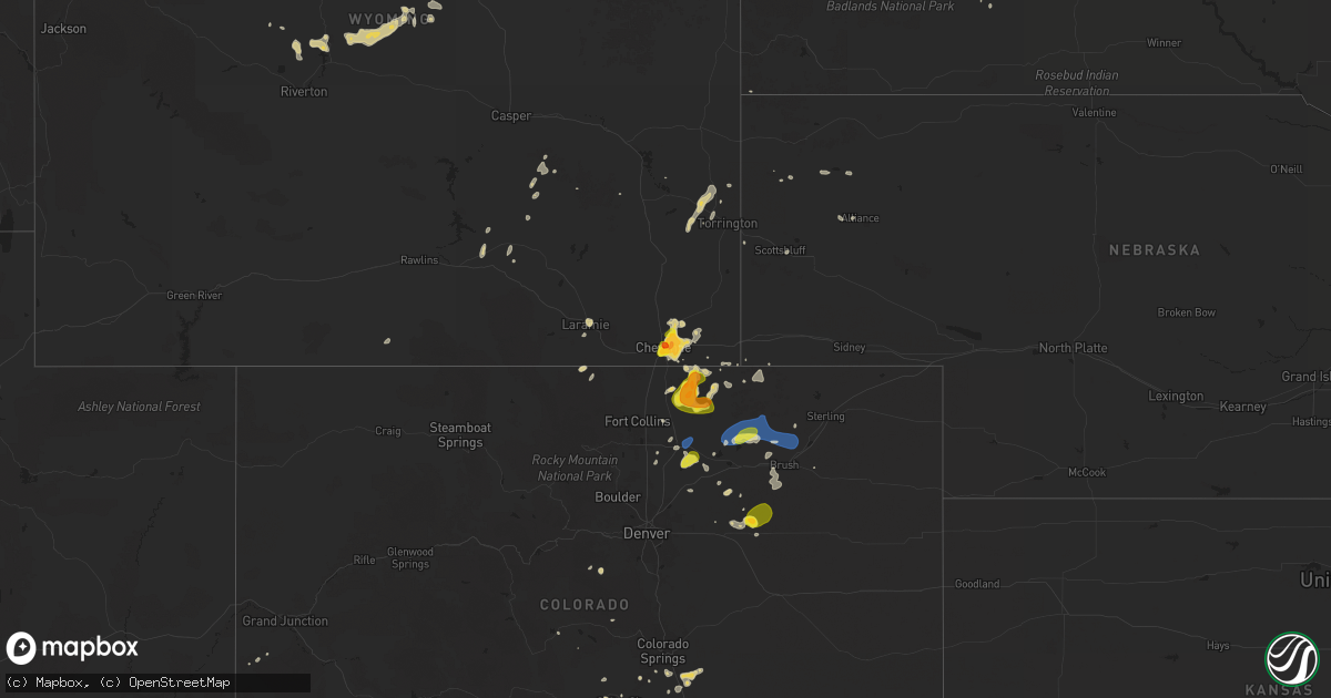
Hail Map on July 31, 2025
Get this storm
July 31 map
$229
one time, instant access
Download today. No call, no setup
Keep the $229
Bought the map and want the full workflow? Apply the entire $229 to a subscription within 7 days. None of it is wasted.
Every map, not just this one
This buys you this map. Subscription and you get every map we run, in the markets you choose from a few cities to whole states to nationwide. Plus real-time alerts the moment a storm fires.
Contact data
Name, contact info, occupancy, even credit band for addresses in the footprint. You go from where it hit to who to call.
Become the source they trust
Unlimited branding weather history reports on demand. You already have the documented answer ready for the property owner, and you are the one who showed up with it.
Property data and RoofTrace estimates
Pull up any address you have got, its value and the exact code rules for that jurisdiction, straight from One Click Code. Then RoofTrace estimates the squares, pitch, and roof value, priced the way you price.
States Impacted by Hail Map on July 31, 2025
Storm reports
Colorado
| Date | Description |
|---|---|
| 07/31/20256:46 PM CDT | Report via spotter network. |
| 07/31/20256:20 PM CDT | A local report indicates 1.00 inch wind near 6 NE Nunn |
| 07/31/20256:12 PM CDT | Loose items blown across yard. |
| 07/31/20255:58 PM CDT | A local report indicates 1.00 inch wind near 1 ENE Milton Reservoir |
| 07/30/20257:55 PM CDT | Awos station k1nw 1 nne new raymer. |
South Carolina
| Date | Description |
|---|---|
| 07/31/20255:38 PM CDT | Lee county dispatch reported trees down on dogwood dr. Time estimated by radar. |
| 07/31/20255:35 PM CDT | Lee county dispatch reported trees down on powerlines on main st. |
| 07/31/20254:40 PM CDT | Fairfield electric cooperative reported trees on powerlines on adger street. Time estimated by radar. |
| 07/31/20254:35 PM CDT | Fairfield electric cooperative reported trees on powerlines on ramsey rd. Time estimated by radar. |
| 07/30/20258:18 PM CDT | A local report indicates 74 MPH wind near 2 WSW Myrtle Beach |
Arkansas
| Date | Description |
|---|---|
| 07/31/20253:55 PM CDT | Trees down along county road 10. |
| 07/31/20253:45 PM CDT | Trees down on highway 71 near blackman ferry road. |
| 07/31/20253:40 PM CDT | Trees down along south stateline avenue. |
| 07/31/20253:23 PM CDT | A large tree limb was downed across highway 41 south between de queen and horatio. |
| 07/31/20253:21 PM CDT | A power line was downed along highway 29 just north of county road 42. |
Kentucky
| Date | Description |
|---|---|
| 07/31/20256:30 PM CDT | Knox county dispatch received a report of downed trees off ky-6 and ky-459 near gray lane from a thunderstorm at 7:30pm. |
| 07/31/20256:14 PM CDT | Knox county dispatch reports a downe |
| 07/31/20256:14 PM CDT | Knox county dispatch reports a downed tree on ky 3441 from the thunderstorms earlier this evening. |
| 07/31/20255:15 PM CDT | Perry county 911 reports downed power lines along ky 451 near meteor lane from the thunderstorm that moved through the krypton area earlier this evening. Time provided |
| 07/31/20255:15 PM CDT | Perry county 911 reports downed power lines along ky 4 |
| 07/31/20255:10 PM CDT | Corrects previous tstm wnd dmg report from 2 n saul. Perry county 911 reports downed power lines in the 300 block of abner fork road from the thunderstorm that moved th |
| 07/31/20254:25 PM CDT | Lee county 911 received a report of a large downed tree along pine grove road east of ky-11 south. Time estimated via radar. |
| 07/31/20253:52 PM CDT | Estill county dispatch reports multiple trees down along white oak road east of ky-89 north of irvine. Time provided by dispatch. |
Virginia
| Date | Description |
|---|---|
| 07/31/20256:00 PM CDT | Tree down in moneta area of bedford county. |
| 07/31/20255:08 PM CDT | Vdot reported a tree a |
| 07/31/20255:08 PM CDT | Vdot reported a tree across the roadway on us-15 in the vicinity of oak hill drive and whitetail road. All north and south lanes were closed. Time estimated from radar. |
| 07/31/20254:32 PM CDT | Power line down reported in the alta vista area. |
| 07/31/20254:15 PM CDT | Vdot reported a tree down across the roadway on route 635 in the vicinity of gallion town road. All north and south lanes were closed. Time estimated from radar. |
| 07/31/20254:07 PM CDT | Vdot reported a tree down across the roadway on route 670 in the vicinity of couches creek road. All north and south lanes were closed. Time estimated from radar. |
| 07/31/20253:56 PM CDT | Tree down along u.s. 50 just east of the clarke county and fauquier county line. |
| 07/31/20253:44 PM CDT | A couple of trees down on craigs store rd. Near the intersection with castle rock rd. |
| 07/31/20253:35 PM CDT | Corrects previous tstm wnd dmg report from 1 e moneta. Tree down in moneta area of bedford county. |
| 07/31/20253:26 PM CDT | Tree down near the intersection of elvan rd. And mountain rd. |
| 07/31/20253:21 PM CDT | Thunderstorm winds blew down one tree near the intersection of joppa mill road and stewartsville road. |
| 07/31/20253:07 PM CDT | Tree down near the intersection of back road and chicory lane. |
| 07/31/20253:03 PM CDT | Tree down near the intersection of crooked run road and senedo rd. |
| 07/31/20252:50 PM CDT | Large tree limb snapped. |
| 07/31/20252:44 PM CDT | A couple of trees down on craigs store rd. Near the intersection with castle rock rd. |
| 07/31/20252:25 PM CDT | Numerous trees down near the intersection of wolfridge rd. And grindstone rd. |
| 07/31/20252:25 PM CDT | Numerous trees down near the intersection of wolfridge rd. And grindstone rd. |
| 07/31/20252:23 PM CDT | Thunderstorm winds blew down one tree along east back street between the intersections of north roanoke street and north church street. |
| 07/31/20252:20 PM CDT | Tree down in the 200 block of dalhousie rd. |
| 07/31/20252:10 PM CDT | Thunderstorm winds blew down one tree near the intersection with dog creek road and moore lane. |
| 07/31/20252:05 PM CDT | Powerline down at rainbow forest drive of timberlake of campbell county. |
| 07/31/20251:56 PM CDT | A few reports of downed trees in the city of staunton. |
| 07/31/20251:05 PM CDT | Multiple reports of trees and powerlines down in the city of lynchburg. |
| 07/31/202512:45 PM CDT | Numerous trees down near the intersection of wolfridge rd. And grindstone rd. |
| 07/30/20257:49 PM CDT | Tree on a home shared via social media. |
Idaho
| Date | Description |
|---|---|
| 07/31/20255:42 PM CDT | Power outage per kootenai electric to over 500 customers. |
| 07/31/20255:42 PM CDT | A local report indicates 1.00 inch wind near 3 NNW Twin Lakes |
| 07/30/20257:30 PM CDT | Mesonet station big coxs well. |
Alabama
| Date | Description |
|---|---|
| 07/31/20254:33 PM CDT | Several large tree limbs downed. |
| 07/31/20254:30 PM CDT | 911 call center reported a tree down along cr 626 sw of section al. |
| 07/31/20254:30 PM CDT | 911 call center reported a tree down along cr 391 se of section al. |
| 07/31/20254:30 PM CDT | 911 call center reported a tree down at 500 cr and 62 blk in section al. |
| 07/31/20254:30 PM CDT | 911 call center reported a tree down at main street and tammy little drive. |
| 07/31/20254:30 PM CDT | Tree downed at main street and tammy little drive in section. |
| 07/31/20254:20 PM CDT | A power line downed near the intersection of goosepond drive and berry road. Time estimated from radar. |
| 07/31/20253:40 PM CDT | Tree down on county highway 47 and power line down on county highway 26. |
| 07/31/20253:05 PM CDT | Tree down at mulberry hills rd and county road 5. Another tree down blocking the road on oscar bradford rd. |
Delaware
| Date | Description |
|---|---|
| 07/31/20251:51 PM CDT | Reported asos measured wind gust of 58 mph. |
Louisiana
| Date | Description |
|---|---|
| 07/31/20255:15 PM CDT | Corrects previous tstm wnd dmg report from winnfield. A small portable building was uplifted and thrown. Multiple trees were downed throughout winnfield. An 18 wheeler |
| 07/31/20255:15 PM CDT | A small portable building was uplifted and thrown. Multiple trees were downed throughout winnfield. |
| 07/31/20254:10 PM CDT | A tree was downed between cullen and springhill. |
| 07/31/20254:06 PM CDT | Multiple trees and power lines down throughout claiborne parish... Including near the athens area. |
Pennsylvania
| Date | Description |
|---|---|
| 07/31/202512:12 PM CDT | Broadcast news report footage showed a tree fallen onto a car in caln twp. Exact road unknown. Time estimated from radar. |
| 07/31/202512:12 PM CDT | Wires down at the intersection of longview drive and barley sheaf road. Wires also down at the intersection of kings highway and n longview drive. Time estimated from r |
| 07/31/202512:09 PM CDT | Tree down blocking both lanes of new geneva road. |
| 07/31/202511:42 AM CDT | Tree br |
| 07/31/202511:42 AM CDT | Tree branch through a house window. Time estimated from radar. |
| 07/31/202511:40 AM CDT | Tree down on wires. Time estimated from radar. |
| 07/31/202511:38 AM CDT | Trees and wires down. Time estimated from radar. |
| 07/31/202511:33 AM CDT | Trees and wires down. Time estimated from radar. |
| 07/31/202511:30 AM CDT | Trees and wires down. Time estimated from radar. |
| 07/31/202511:30 AM CDT | Multiple trees down on wires at the intersection of elizabeth ave and chestnut street. Time estimated from radar. |
| 07/31/202511:23 AM CDT | Berks 911 call center reported a tree down on conrad weiser pkwy. Time estimated from radar. |
| 07/31/202510:50 AM CDT | Tree blocking road. |
| 07/31/202510:47 AM CDT | Wires down. |
West Virginia
| Date | Description |
|---|---|
| 07/31/20255:30 PM CDT | Three trees down around shepherdstown. |
| 07/31/20255:30 PM CDT | Three trees down arou |
| 07/31/20253:21 PM CDT | Tree down on the 300 block of york street. |
| 07/31/20253:03 PM CDT | Three trees down around shepherdstown. |
| 07/31/20252:47 PM CDT | A few trees down along foxcroft ave. In martinsburg. |
| 07/31/20252:40 PM CDT | Tree down around mm 23 on interstate 81. |
| 07/31/20252:39 PM CDT | Tree down at the intersection of koonztown rd. And yukon dr. |
Wyoming
| Date | Description |
|---|---|
| 07/31/20255:25 PM CDT | Report from mping: half dollar |
| 07/31/20255:12 PM CDT | Report from mping: golf ball |
| 07/31/20255:10 PM CDT | A local report indicates 1.25 inch wind near 1 WNW Cheyenne |
| 07/30/20258:37 PM CDT | Mesonet station khld hiland 2.4 se |
New Jersey
| Date | Description |
|---|---|
| 07/31/20252:34 PM CDT | Wires down. Time estimated from radar. |
| 07/31/202512:50 PM CDT | Trees down. Time estimated from radar. |
| 07/31/202512:45 PM CDT | Trees and wires down. Time estimated from radar. |
South Dakota
| Date | Description |
|---|---|
| 07/31/20252:45 AM CDT | A local report indicates 68 MPH wind near 6 W Cottonwood |
Utah
| Date | Description |
|---|---|
| 07/31/20254:35 PM CDT | Interstate 80 |
Texas
| Date | Description |
|---|---|
| 07/31/20255:48 PM CDT | A local report indicates 1.00 inch wind near Archer City |
| 07/31/20255:45 PM CDT | A 60 mph wind gust was measured at the eastman chemical company southeast of longview... Which resulted in some structural damage. |
| 07/30/20258:05 PM CDT | Unconfirmed report of wind damage at a rv park on fox lane with reports of rvs |
| 07/30/20258:05 PM CDT | Unconfirmed report of wind damage at a rv park on fox lane with reports of rvs blown over. Grayson county ema investigating. |
| 07/30/20257:55 PM CDT | Facebook photos showed several trees blown down on amen corner off cr 179. |
Maryland
| Date | Description |
|---|---|
| 07/31/20254:45 PM CDT | Several trees down along egypt rd. |
| 07/31/20254:28 PM CDT | Several trees down around monrovia. |
| 07/31/20254:15 PM CDT | Several trees down around monrovia. |
| 07/31/20253:56 PM CDT | Several trees down around ijamsville |
| 07/31/20253:26 PM CDT | Several trees were down in middletown. |
| 07/31/20253:26 PM CDT | Several trees were down in middletown. |
| 07/31/20253:26 PM CDT | Several trees down around myersville. |
| 07/31/20253:24 PM CDT | Trees down. Time estimated from radar. |
| 07/31/20253:08 PM CDT | Multiple trees down. Time estimated from radar. |
| 07/31/20252:55 PM CDT | A couple of trees down along dam number 4 rd. And also on scrabble rd. |
| 07/31/20252:00 PM CDT | A few trees were down around hancock. |
| 07/31/202512:41 PM CDT | A few trees were down around hancock. |
Montana
| Date | Description |
|---|---|
| 07/31/20256:53 PM CDT | Asos station klvm livingston. |
| 07/31/20256:52 PM CDT | Multiple facebook photos in the southern lolo area depicted up to golf ball sized hail. The photo that showed possible golf ball was wide and flat. |
| 07/30/202510:30 PM CDT | A local report indicates 1.25 inch wind near 1 SSE Great Falls |
| 07/30/202510:15 PM CDT | Mesonet station mtelm elmo us-93 mp 77.5. |
| 07/30/202510:15 PM CDT | Mesonet sta |
| 07/30/202510:10 PM CDT | Time |
| 07/30/20259:30 PM CDT | Golf ball sized hail. |
District of Columbia
| Date | Description |
|---|---|
| 07/31/20253:34 PM CDT | Large tree down near the intersection of connecticut ave and chesapeake st nw. |
| 07/31/20253:33 PM CDT | Tree down on an unoccupied vehicle at the intersection of ellicott st. Nw and 32nd st. Nw. |
Florida
| Date | Description |
|---|---|
| 07/31/20252:10 PM CDT | A tree resulted in a power outage via talquin electric outage map. |
| 07/31/20252:08 PM CDT | A tree resulted in a power outage via talquin electric outage map. |
North Carolina
| Date | Description |
|---|---|
| 07/31/20255:43 PM CDT | Duke energy outage caused by fallen trees or limbs damaging equipment. |
| 07/31/20255:12 PM CDT | Power lines down on the 1700 block of aman dairy rd. Radar estimated time. |
| 07/31/20254:30 PM CDT | Tree fell on a house on chickadee lane in savannah community. First responders indicated multiple trees down in vicinity. Time approximate. Report submitted via x. |
| 07/31/20252:31 PM CDT | Wfmy passed along a photo of a tree down on a power line on charlotte dr. Event time estimated from radar. |
Cities Impacted by Hail Map on July 31, 2025
- Riverton, WY
- Shoshoni, WY
- Timbo, AR
- Prim, AR
- Drasco, AR
- Higden, AR
- Atkins, AR
- Heber Springs, AR
- Center Ridge, AR
- Clinton, AR
- Bee Branch, AR
- Lancaster, PA
- Mountville, PA
- Pine Grove, PA
- Robesonia, PA
- Bernville, PA
- Millersville, PA
- Cairo, WV
- Mohrsville, PA
- Wernersville, PA
- Reading, PA
- Walker, WV
- Leesport, PA
- Temple, PA
- Waynesburg, PA
- Mount Morris, PA
- Spraggs, PA
- Vine Grove, KY
- Rineyville, KY
- Elizabethtown, KY
- Dilliner, PA
- Kingsville, MD
- White Marsh, MD
- Perry Hall, MD
- Nottingham, MD
- Hot Springs Village, AR
- Hot Springs National Park, AR
- Malvern, AR
- Joppa, MD
- Bridgewater, NJ
- Warren, NJ
- Martinsville, NJ
- Basking Ridge, NJ
- Bedford, PA
- Oliver Springs, TN
- Bay, AR
- Jonesboro, AR
- Middle River, MD
- Spring City, TN
- Grandview, TN
- Chattanooga, TN
- Dunellen, NJ
- Watchung, NJ
- Everett, PA
- Trumann, AR
- Harriman, TN
- Plainfield, NJ
- Clearville, PA
- Pearcy, AR
- Piscataway, NJ
- South Plainfield, NJ
- Beaver Dam, KY
- Morgantown, KY
- Leola, AR
- Lynn, AL
- Haleyville, AL
- Arkadelphia, AR
- Edison, NJ
- Bowie, MD
- Glenn Dale, MD
- Bismarck, AR
- La Fayette, GA
- Rock Spring, GA
- Artemas, PA
- Warfordsburg, PA
- Iselin, NJ
- Metuchen, NJ
- Cromwell, KY
- Woodbridge, NJ
- Fords, NJ
- Mount Ida, AR
- Sparkman, AR
- Annapolis, MD
- Weir, MS
- Ackerman, MS
- Oneonta, AL
- Okolona, AR
- Gurdon, AR
- Nashville, AR
- Perth Amboy, NJ
- Sweetwater, TN
- Niota, TN
- Murfreesboro, AR
- Ozark, AR
- Cleveland, TN
- Hancock, MD
- Sewaren, NJ
- Keasbey, NJ
- Newark, DE
- New Castle, DE
- Oark, AR
- Bearden, AR
- Bowling Green, KY
- Rochester, KY
- Carthage, AR
- Kosciusko, MS
- Caddo Gap, AR
- Norman, AR
- Parkton, MD
- White Hall, MD
- Bluff City, AR
- Prescott, AR
- Chidester, AR
- Penns Grove, NJ
- Cohutta, GA
- Crandall, GA
- Old Fort, TN
- Fayetteville, TN
- Mulberry, AR
- Jasper, AL
- Arley, AL
- Camden, AR
- Carthage, MS
- Alma, AR
- Dyer, AR
- Chatsworth, GA
- Dalton, GA
- Berkeley Springs, WV
- Smiths Grove, KY
- Oakland, KY
- Hazel Green, AL
- Alvaton, KY
- Charleston, AR
- Bishopville, SC
- Magnolia, AR
- Gateway, CO
- Rosston, AR
- Benton, TN
- Ocoee, TN
- Fisher, WV
- Moorefield, WV
- Scottsville, KY
- Bremen, AL
- Cecil, AR
- Rudy, AR
- Falling Waters, WV
- Williamsport, MD
- Fairplay, MD
- Boonsboro, MD
- Shepherdstown, WV
- Sharpsburg, MD
- Keedysville, MD
- Rohrersville, MD
- Whitewater, CO
- Wardensville, WV
- Aberdeen, MS
- Thaxton, VA
- Afton, VA
- Hagerstown, MD
- Enoree, SC
- Hayden, AL
- Warrior, AL
- Vinton, VA
- Blue Ridge, VA
- Martinsburg, WV
- Hedgesville, WV
- Clear Spring, MD
- Tallahassee, FL
- Knoxville, MD
- Magazine, AR
- Booneville, AR
- Preston, MS
- Lavaca, AR
- Emmet, AR
- Waldron, AR
- Bedford, VA
- Van Buren, AR
- Reliance, TN
- Emerson, AR
- Maryville, TN
- Empire, AL
- Myersville, MD
- Hampton, AR
- Hope, AR
- Ashdown, AR
- Grants, NM
- De Queen, AR
- Blountsville, AL
- Washington, AR
- Star Tannery, VA
- Garland City, AR
- Texarkana, AR
- Haynesville, LA
- Ogden, AR
- Horatio, AR
- Grand View, ID
- Macdoel, CA
- Lockesburg, AR
- Lewisville, AR
- Adairsville, GA
- Fort Smith, AR
- Strasburg, VA
- Roland, OK
- Piedmont, AL
- Rattan, OK
- Eagletown, OK
- Texarkana, TX
- Parks, AR
- Fort Towson, OK
- Arkoma, OK
- Scottsboro, AL
- Snow, OK
- Foreman, AR
- Groveoak, AL
- Spiro, OK
- Irvine, KY
- Paris, VA
- Boyce, VA
- Ravenna, KY
- Springhill, LA
- Clayton, OK
- Cambridge, MD
- Fyffe, AL
- Pocola, OK
- Cameron, OK
- Beattyville, KY
- Heavener, OK
- Bienville, LA
- Parsons, TN
- Cubero, NM
- Sarepta, LA
- Gordo, AL
- Reform, AL
- Madison, MD
- Church Creek, MD
- Woolford, MD
- Klamath Falls, OR
- Athens, LA
- Homer, LA
- Minden, LA
- Hodgen, OK
- Laramie, WY
- Bells, TN
- Gibsland, LA
- Cheyenne, WY
- Haskell, TX
- Pine, CO
- Bailey, CO
- Fe Warren Afb, WY
- Weinert, TX
- Smithville, OK
- Dairy, OR
- Arcadia, LA
- Guntersville, AL
- Arab, AL
- Farmington, NM
- Simsboro, LA
- Tremont, MS
- Fulton, MS
- Story, AR
- Shannon, NC
- Red Springs, NC
- Dalzell, SC
- Camden, SC
- Rembert, SC
- Brownsville, TN
- Fort Garland, CO
- Mentone, AL
- Hope Mills, NC
- Moyers, OK
- Dubberly, LA
- Godwin, NC
- Wade, NC
- Hanna, WY
- Ringgold, LA
- Watson, OK
- Jamestown, LA
- Antlers, OK
- Bethel, OK
- La Salle, CO
- Kersey, CO
- Windthorst, TX
- Archer City, TX
- Fayetteville, NC
- Humboldt, TN
- Trenton, TN
- Mason, TN
- Parkton, NC
- Eagle Point, OR
- White City, OR
- Ault, CO
- Grover, CO
- Scotland, TX
- Nunn, CO
- Kingston, ID
- White Sulphur Springs, MT
- Nogales, AZ
- Medicine Bow, WY
- Byhalia, MS
- Red Banks, MS
- Tuskahoma, OK
- Upperville, VA
- Saint Pauls, NC
- Stanton, TN
- Oakland, TN
- Ringling, MT
- Holly Springs, MS
- Rossville, TN
- Crossett, AR
- Livermore, CO
- Toston, MT
- Townsend, MT
- Greenville, MS
- Garrett, WY
- Hayden, ID
- Lamar, MS
- Hartshorne, OK
- Greeley, CO
- Gill, CO
- Pierce, CO
- Briggsdale, CO
- Orchard, CO
- Weldona, CO
- Nespelem, WA
- Riverside, WA
- Wilburton, OK
- Rathdrum, ID
- Athol, ID
- Roggen, CO
- Holliday, TX
- Johnstown, CO
- Milliken, CO
- Mansfield, LA
- Glenrock, WY
- Lawrenceville, GA
- Loganville, GA
- Unity, OR
- Colville, WA
- Mullan, ID
- Kettle Falls, WA
- Evans, CO
- De Kalb, TX
- Walnut, MS
- Falkner, MS
- Priest River, ID
- Fort Jones, CA
- Usk, WA
- Dixon, WY
- Converse, LA
- Fort Morgan, CO
- New Raymer, CO
- Snyder, CO
- Cave Junction, OR
- Elk, WA
- Newport, WA
- Hillsdale, WY
- Burns, WY
- Coffee Creek, MT
- Buffalo, WY
- Ashland, MS
- Geyser, MT
- East Helena, MT
- Winston, MT
- Selma, OR
- Newport News, VA
- Damascus, AR
- Seymour, TX
- Lysite, WY
- Geraldine, MT
- Otter, MT
- Platteville, CO
- Clearmont, WY
- Keenesburg, CO
- Carter, MT
- Floweree, MT
- Myrtle Beach, SC
- Drummond, MT
- Boyle, MS
- Shaw, MS
- Anna, TX
- Van Alstyne, TX
- Cleveland, NM
- Helena, MT
- Turrell, AR
- Tyronza, AR
- Valley View, TX
- Gainesville, TX
- Mora, NM
- Muenster, TX
- Lindsay, TX
- Weiner, AR
- Celina, TX
- Power, MT
- La Grande, OR
- Yoder, WY
- Fort Laramie, WY
- Carr, CO
- Arvada, WY
- Gilmore, AR
- Earle, AR
- Florence, MT
- Missoula, MT
- Lolo, MT
- Taft, TN
- Gunter, TX
- Howe, TX
- Fort Benton, MT
- Byers, CO
- Jordan, MT
- Belgrade, MT
- Carpenter, WY
- Loma, MT
- Crawfordsville, AR
- Jacksonville, OR
- Sherman, TX
- Wolf Creek, MT
- Gildford, MT
- Great Falls, MT
- Lingle, WY
- Jay Em, WY
- Whitesboro, TX
- Lakehead, CA
- Hopkins, SC
- Monette, AR
- Black Oak, AR
- Black Eagle, MT
- Big Sandy, MT
- Caraway, AR
- Huntsville, TN
- Ten Sleep, WY
- Olla, LA
- Rye, CO
- Clancy, MT
- Lyman, NE
- Jacksboro, TX
- Elmo, MT
- Big Arm, MT
- Polson, MT
- Mccall, ID
- Ashland, MT
- Lame Deer, MT
- Kaycee, WY
- Decker, MT
- Amagon, AR
- Bowie, TX
- McCrory, AR
- Hickory Ridge, AR
- Pioneer, TN
- Oneida, TN
- Box Elder, MT
- Walsenburg, CO
- Torrington, WY
- Forsyth, MT
- Bellevue, TX
- Lodge Grass, MT
- Batesville, AR
- Pueblo, CO
- Colorado City, CO
- Marked Tree, AR
- Lepanto, AR
- Scottsbluff, NE
- Stanford, MT
- Garrison, MT
- Merino, CO
- Ashton, ID
- Fountain, CO
- Penrose, CO
- Roy, NM
- Colorado Springs, CO
- Council, ID
- Alliance, NE
- Vaughn, MT
- Cotopaxi, CO
- Canon City, CO
- Marsland, NE
- Wiggins, CO
- Fairfield, MT
- Choteau, MT
- Belle Fourche, SD
- Deer Trail, CO
- Wallowa, OR
- Hemingford, NE
- Chester, MT
- Lloyd, MT
- Ekalaka, MT
- Wasta, SD
- Howes, SD
- Kinsey, MT
- Quinn, SD
- Ismay, MT
- Miles City, MT
- Camp Crook, SD
- Booneville, KY
- Kadoka, SD
- Wanblee, SD
- Zortman, MT
- Chinook, MT
- Philip, SD
- Manchester, KY
- Hays, MT
- Jackson, KY
- Malta, MT
- Harlem, MT
- Dodson, MT
- Longview, TX
- Dutton, MT
- Spirit Lake, ID