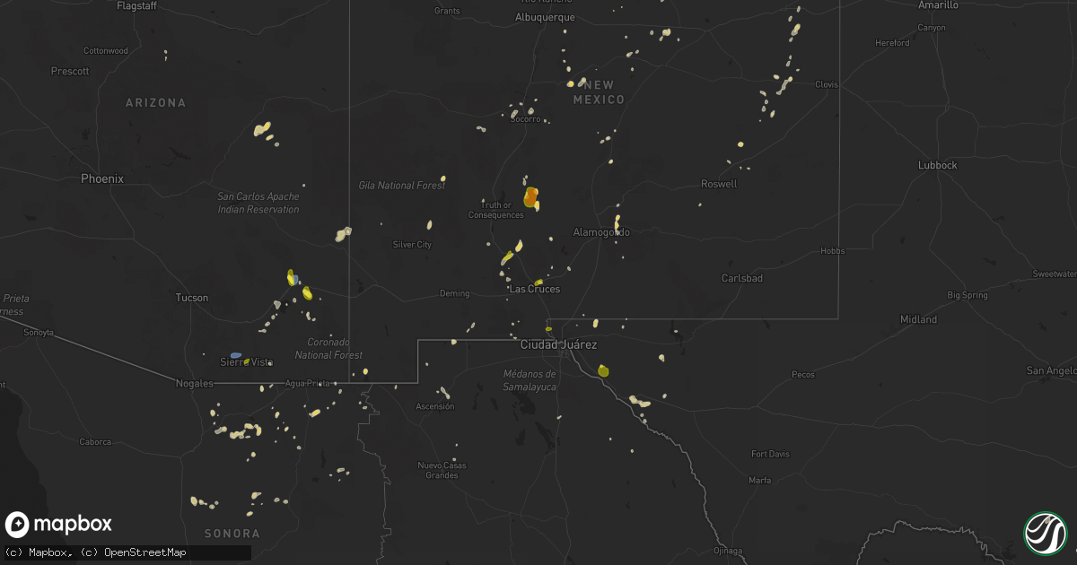
Hail Map on July 13, 2025
Get this storm
July 13 map
$229
one time, instant access
Download today. No call, no setup
Keep the $229
Bought the map and want the full workflow? Apply the entire $229 to a subscription within 7 days. None of it is wasted.
Every map, not just this one
This buys you this map. Subscription and you get every map we run, in the markets you choose from a few cities to whole states to nationwide. Plus real-time alerts the moment a storm fires.
Contact data
Name, contact info, occupancy, even credit band for addresses in the footprint. You go from where it hit to who to call.
Become the source they trust
Unlimited branding weather history reports on demand. You already have the documented answer ready for the property owner, and you are the one who showed up with it.
Property data and RoofTrace estimates
Pull up any address you have got, its value and the exact code rules for that jurisdiction, straight from One Click Code. Then RoofTrace estimates the squares, pitch, and roof value, priced the way you price.
States Impacted by Hail Map on July 13, 2025
Storm reports
Texas
| Date | Description |
|---|---|
| 07/13/20255:55 PM CDT | Large tree down on the attoyac river bridge. A vehicle hit the tree but no injuries were reported. |
| 07/13/20255:55 PM CDT | Several trees and powerlines downed... Especially near and north of carthage texas. |
| 07/13/20255:55 PM CDT | Several trees and powe |
| 07/13/20255:50 PM CDT | Report of a tree down on a powerline near hwy 59 southwest of domino. |
| 07/13/20255:50 PM CDT | Report of a tree down on fm 2199 just north of i-20. |
| 07/13/20255:50 PM CDT | Report of a tree down on fm 31 south of i-20. |
| 07/13/20255:35 PM CDT | Reports of trees and powerlines down across the county... Especially near hooks and leary... Tx. |
| 07/13/20255:02 PM CDT | The west texas mesonet station 123 1nw castolon bbnp measured a 64 mph thunderstorm wind gust. |
| 07/13/20254:51 PM CDT | Report of a large tree down in hughes springs from nws employee on social media. |
Minnesota
| Date | Description |
|---|---|
| 07/13/20256:28 PM CDT | Corrects previous tstm wnd dmg report from 1 w barry. Trained spotter sent images of numerous tree limbs down... Up to 18 in diameter... As well as small trees snapped |
| 07/13/20256:28 PM CDT | Image sent via x of trees down in the town of barry. |
| 07/13/20256:19 PM CDT | 6-10 diameter tree branches snapped at the intersection of mn-28 and big stone county road 59. Image sent via x. |
| 07/13/20256:19 PM CDT | 6-10 diameter t |
| 07/13/20256:19 PM CDT | 6-10 diame |
| 07/13/20256:17 PM CDT | Trained spotter reported 61mph wind gust from a rooftop anemometer at the intersection of mn-28 and big stone county road 59 in a wet microburst. Crop damage was also r |
Illinois
| Date | Description |
|---|---|
| 07/13/20252:28 PM CDT | Tree down near the intersection of levee and branch roads. Time estimated from radar. |
Montana
| Date | Description |
|---|---|
| 07/13/202512:40 AM CDT | Mesonet station gw6392 gildford 15n. |
| 07/12/202511:57 PM CDT | Mesonet station gw0637 bears den 9 ene. |
| 07/12/202511:54 PM CDT | Ambient weather station. |
| 07/12/202511:35 PM CDT | Mesonet station gw3546 whitlash seven south. More exact timing estimated based on radar. |
North Carolina
| Date | Description |
|---|---|
| 07/13/20256:45 PM CDT | Trees reported down on a few homes. |
| 07/13/202512:55 PM CDT | Tree down on utility lines causing power outage. |
| 07/13/202512:40 PM CDT | Tree down on utility lines resulting in power outage. |
| 07/13/202511:35 AM CDT | Tree down on driveway near cedar creek road. |
| 07/13/202511:27 AM CDT | Tree down on powerlines. |
| 07/13/202511:25 AM CDT | Tree down on power lines. |
| 07/12/20258:00 PM CDT | Several trees reported down and around 1000 power outages. |
Alabama
| Date | Description |
|---|---|
| 07/13/20256:47 PM CDT | A tree was knocked down into the roadway at 6779 cr 63 in woodville. Time estimated by radar. |
| 07/13/20255:49 PM CDT | A large tree limb was knocked down into the roadway at 6230 tammy little drive in section. Time estimated by radar of the gust front passage. |
| 07/13/20254:29 PM CDT | A tree was knocked down at 13800 cr 33. Time estimated by radar. |
| 07/13/20252:03 PM CDT | Em reported several trees down/uprooted in downtown dothan. |
Virginia
| Date | Description |
|---|---|
| 07/13/20256:56 PM CDT | Tree and large branches and limbs downed by thunderstorm winds in the 6300 block of jubal early highway. |
| 07/13/20256:16 PM CDT | Tree down across jubal early highway in hardy of franklin county. |
| 07/13/20256:00 PM CDT | A large tree was blown down near the 6500 block of jubal early highway by thunderstorm winds. |
| 07/13/20255:32 PM CDT | Tree down across hollins road. |
Kentucky
| Date | Description |
|---|---|
| 07/13/20254:55 PM CDT | Power lines down on n. Jessup street in hopkinsville. Tree also partially blocking the road. |
| 07/13/20254:50 PM CDT | Power lines down on ft. Campbell blvd. |
Louisiana
| Date | Description |
|---|---|
| 07/13/20256:28 PM CDT | Trees downed near adger road and eclipse road just northeast of gilliam... Louisiana. |
| 07/13/20256:26 PM CDT | Trees down on sartor road and pearce lane near gilliam... Louisiana. |
| 07/13/20256:26 PM CDT | Large tree down near hwy 169 and blanchard latex road. |
Florida
| Date | Description |
|---|---|
| 07/13/20255:36 PM CDT | Tree down and power pole down due to thunderstorm wind damage. |
| 07/13/20253:15 PM CDT | Tree down on w c currington rd. |
| 07/13/20253:15 PM CDT | Tree down on magnolia rd. |
| 07/13/20251:08 PM CDT | The orlando/sanford airport measured a peak wind gust of 58mph/50kt from the west at 2:08 pm. |
Mississippi
| Date | Description |
|---|---|
| 07/13/20254:38 PM CDT | A tree was blown down on rankin county line road. |
| 07/13/20254:08 PM CDT | A tree was blown down outside of the star community... And blocked both lanes of hwy 49 south. |
| 07/13/20254:00 PM CDT | A tree was blown down on barnett bend circle. The tree blocked both lanes of the road. |
| 07/13/20253:48 PM CDT | Trees were blown down in the crystal springs area. |
| 07/13/20253:30 PM CDT | Trees were blown down south of hazlehurst. |
| 07/13/20253:18 PM CDT | Trees were blown down on martinsville road. |
| 07/13/20253:15 PM CDT | Corrects previous tstm wnd dmg report from 1 nnw wesson. Trees were blown down on sylvarena road. |
| 07/13/20252:55 PM CDT | Scattered trees and power lines were blown down in the brookhaven area. |
| 07/13/20252:41 PM CDT | Report of downed tree along the natchez trace near lorman... Ms. |
| 07/13/20252:01 PM CDT | Image shared of a large semi trailer overturned in a parking lot adjacent to stateline road. |
| 07/13/20252:01 PM CDT | Multiple trees reported to be down across southaven. |
Arizona
| Date | Description |
|---|---|
| 07/12/20259:52 PM CDT | Damage to roof due to thunderstorm winds. |
| 07/12/20258:56 PM CDT | Awos station kalk measured wind gust of 62 mph. |
| 07/12/20258:33 PM CDT | Awos station kalk measured wind gust of 58 mph. |
| 07/12/20257:50 PM CDT | Corrects time of previous tstm wnd dmg report damage to roof due to thunderstorm winds. |
New York
| Date | Description |
|---|---|
| 07/13/20254:55 PM CDT | Trees and power lines down on campsite road. |
| 07/13/20254:42 PM CDT | Tree down in power lines. Time estimated by radar. |
| 07/13/20254:28 PM CDT | Trees and power lines down on maggy road. |
| 07/13/20253:42 PM CDT | Report of downed trees with one laying on utility wires on county rd 77. Time estimated by radar. |
| 07/13/20253:02 PM CDT | Tree downed on route 177 in copenhagen blocking the road near river road. |
| 07/13/20252:55 PM CDT | Tree down on road. Time approximated by radar. |
| 07/13/20251:25 PM CDT | Downed trees on county route 24... Southwest of fullerville. |
Cities Impacted by Hail Map on July 13, 2025
- Marianna, FL
- Trenton, IL
- Monterey, LA
- Sanford, FL
- Oviedo, FL
- Winter Springs, FL
- Aviston, IL
- Breese, IL
- Edgewater, FL
- Gordon, AL
- Athens, TX
- Webb, AL
- Oak Hill, FL
- Dillwyn, VA
- Youngstown, FL
- New Caney, TX
- Liberty, MS
- Ormond Beach, FL
- Satsuma, FL
- Cameron, SC
- Splendora, TX
- Smithdale, MS
- Timberon, NM
- Orangeburg, SC
- Chipley, FL
- Cloudcroft, NM
- Welaka, FL
- Pomona Park, FL
- Bogue Chitto, MS
- Brookhaven, MS
- Charlotte Court House, VA
- Cullen, VA
- Flora, IL
- Currie, NC
- Kelly, NC
- Atkinson, NC
- Georgetown, FL
- Crescent City, FL
- Bowman, SC
- Merritt Island, FL
- Newville, AL
- La Luz, NM
- High Rolls Mountain Park, NM
- Defuniak Springs, FL
- Ponce De Leon, FL
- Hanover, NM
- Silver City, NM
- Remsen, NY
- Forestport, NY
- Clay City, IL
- Wesson, MS
- Hazlehurst, MS
- Crystal Springs, MS
- Harrisville, NY
- Louisville, IL
- Fort McCoy, FL
- Harrisville, MS
- Florence, MS
- Terry, MS
- Fort Pierce, FL
- Noble, IL
- Sailor Springs, IL
- Hartsville, SC
- Truth Or Consequences, NM
- Mescalero, NM
- Olney, IL
- Braxton, MS
- Brandon, MS
- Pelahatchie, MS
- Morton, MS
- Monticello, FL
- Robersonville, NC
- Patoka, IN
- Saint Joseph, TN
- Loretto, TN
- Forest, MS
- Pulaski, MS
- Big Rock, TN
- Bumpus Mills, TN
- Cadiz, KY
- Fort Campbell, KY
- La Fayette, KY
- Herndon, KY
- Oak Grove, KY
- Hopkinsville, KY
- Pembroke, KY
- Sapello, NM
- Spencer, NE
- Clearville, PA
- Las Vegas, NM
- Greenville, FL
- Carthage, TX
- Beckville, TX
- Stanley, NM
- Cliff, NM
- Las Cruces, NM
- Lufkin, TX
- El Paso, TX
- Fort Bliss, TX
- Canton, MS
- Oneill, NE
- Mount Vernon, IN
- Wadesville, IN
- New Harmony, IN
- Canastota, NY
- Poseyville, IN
- Waskom, TX
- Bethany, LA
- Haughton, LA
- Minden, LA
- Greenwood, LA
- De Berry, TX
- Barksdale Afb, LA
- Keithville, LA
- Marshall, TX
- Tatum, TX
- Bossier City, LA
- Shreveport, LA
- Princeton, LA
- San Augustine, TX
- Timpson, TX
- Tenaha, TX
- Center, TX
- Nacogdoches, TX
- Chireno, TX
- Garrison, TX
- Dundas, IL
- Sierra Vista, AZ
- Fort Huachuca, AZ
- Washington, IN
- Carrizozo, NM
- Whiteriver, AZ
- Monroe City, IN
- Willcox, AZ
- San Simon, AZ
- Mountainair, NM
- Siler City, NC
- Bear Creek, NC
- Gresham, SC
- Endicott, NY
- Owego, NY
- Montezuma, NM
- Rincon, NM
- Hazleton, IN
- Vaughn, NM
- Bowie, AZ
- Barry, MN
- Graceville, MN
- Duncan, AZ
- Hatch, NM
- Orrstown, PA
- Long Branch, TX
- Mount Enterprise, TX
- Gilbertown, AL
- Mora, NM
- Pleasant Hall, PA
- Fort Stewart, GA
- Dumont, MN
- Beardsley, MN
- Lake George, CO
- Ellabell, GA
- La Mesa, NM
- Arab, AL
- Cullman, AL
- Pleasanton, TX
- Campbellton, TX
- Woodville, AL
- Shelbyville, KY
- Pansey, AL
- Eagle Pass, TX
- Rocksprings, TX
- Utica, KY
- Petersburg, IN
- Hartford, KY
- Peridot, AZ
- Willard, NM
- Elgin, AZ
- Buena Vista, CO
- Paint Rock, AL
- Huachuca City, AZ
- Magdalena, NM
- Sierra Blanca, TX
- San Mateo, FL
- Louisville, KY
- Simpsonville, KY
- Bunnell, FL
- Polvadera, NM
- Cochise, AZ
- Saint David, AZ
- Tombstone, AZ
- Bisbee, AZ
- Hastings, FL
- East Palatka, FL
- Georgetown, CO
- Chambersburg, PA
- Dumont, CO
- Idaho Springs, CO
- Canutillo, TX
- Whitlash, MT
- Joplin, MT
- Inverness, MT
- Rudyard, MT
- Hingham, MT
- Havre, MT
- Gildford, MT
- Kremlin, MT
- Galata, MT
- Sweet Grass, MT
- Sunburst, MT
- Chinook, MT
- Brackettville, TX
- Zurich, MT
- Tucumcari, NM
- Melrose, NM
- Roswell, NM