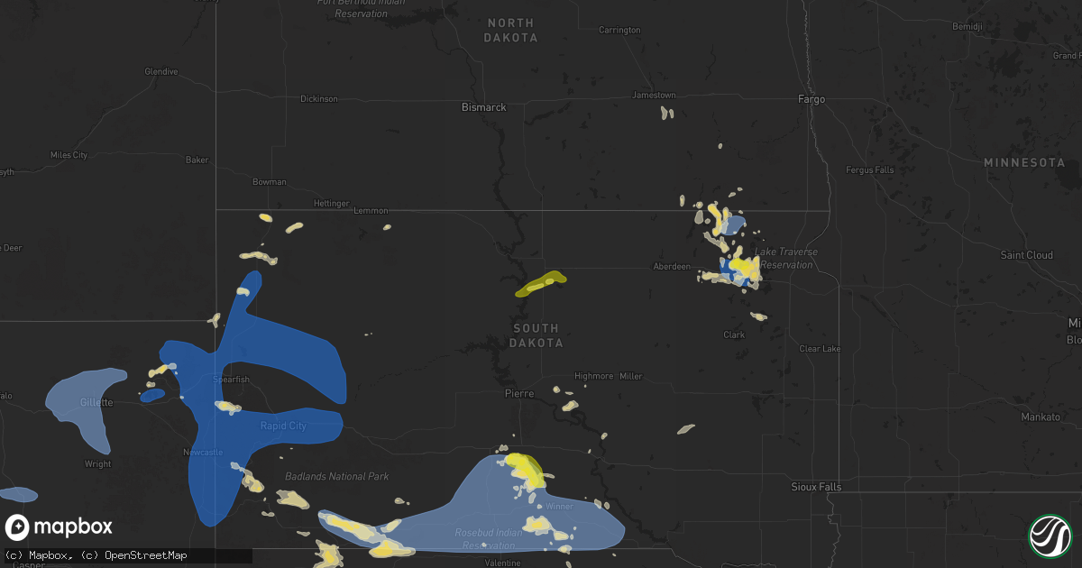
Hail Map on August 13, 2025
Get this storm
August 13 map
$229
one time, instant access
Download today. No call, no setup
Keep the $229
Bought the map and want the full workflow? Apply the entire $229 to a subscription within 7 days. None of it is wasted.
Every map, not just this one
This buys you this map. Subscription and you get every map we run, in the markets you choose from a few cities to whole states to nationwide. Plus real-time alerts the moment a storm fires.
Contact data
Name, contact info, occupancy, even credit band for addresses in the footprint. You go from where it hit to who to call.
Become the source they trust
Unlimited branding weather history reports on demand. You already have the documented answer ready for the property owner, and you are the one who showed up with it.
Property data and RoofTrace estimates
Pull up any address you have got, its value and the exact code rules for that jurisdiction, straight from One Click Code. Then RoofTrace estimates the squares, pitch, and roof value, priced the way you price.
States Impacted by Hail Map on August 13, 2025
Storm reports
Louisiana
| Date | Description |
|---|---|
| 08/13/20256:29 PM CDT | Large tree and small branches snapped in central due to thunderstorm winds. Report relayed by broadcast media. |
Mississippi
| Date | Description |
|---|---|
| 08/13/20256:23 PM CDT | Emergency management reported a tree down on drag strip rd in brooklyn. |
| 08/13/20252:35 PM CDT | Law enforcement reported a few trees down near self creek rd. |
| 08/13/20252:30 PM CDT | Law enforcement reported a tree down on travis st near west point. |
South Dakota
| Date | Description |
|---|---|
| 08/13/20256:51 PM CDT | A local report indicates 64 MPH wind near 3 NW Wasta |
| 08/13/20256:35 PM CDT | A local report indicates 64 MPH wind near 2 E Elm Springs |
| 08/13/20256:35 PM CDT | A local report indicates 62 MPH wind near 10 W Reva |
| 08/13/20256:31 PM CDT | A local report indicates 58 MPH wind near 3 NW Wasta |
| 08/13/20256:15 PM CDT | A local report indicates 58 MPH wind near 11 SSE Hereford |
| 08/13/20256:14 PM CDT | A local report indicates 62 MPH wind near 3 W Union Center |
| 08/13/20256:05 PM CDT | A local report indicates 69 MPH wind near 6 WSW Fairpoint |
| 08/13/20256:00 PM CDT | A local report indicates 63 MPH wind near Ellsworth AFB |
| 08/13/20255:59 PM CDT | A local report indicates 61 MPH wind near 1 W Box Elder |
| 08/13/20255:58 PM CDT | A local report indicates 63 MPH wind near Ellsworth AFB |
| 08/13/20255:55 PM CDT | A local report indicates 64 MPH wind near 3 N Redig |
| 08/13/20255:52 PM CDT | A local report indicates 59 MPH wind near Ellsworth AFB |
| 08/13/20255:38 PM CDT | A local report indicates 60 MPH wind near Piedmont |
| 08/13/20255:35 PM CDT | A local report indicates 59 MPH wind near 7 E Sturgis |
| 08/13/20255:30 PM CDT | A local report indicates 58 MPH wind near 1 NNW Nisland |
| 08/13/20255:27 PM CDT | A local report indicates 60 MPH wind near 7 SW Custer |
| 08/13/20255:24 PM CDT | A local report indicates 58 MPH wind near 12 WSW Castle Rock |
| 08/13/20255:24 PM CDT | A local report indicates 60 MPH wind near 10 W Edgemont |
| 08/13/20255:15 PM CDT | Time estimated based on radar |
| 08/13/20255:14 PM CDT | A local report indicates 60 MPH wind near 10 W Edgemont |
| 08/13/20259:38 AM CDT | Nickel to quarter sized hail. |
| 08/13/20252:48 AM CDT | Mesonet station 179 sd rwis tyndall. |
| 08/13/20252:30 AM CDT | Wind damaged awning on a camper trailer. |
| 08/13/20252:30 AM CDT | Wind damaged awn |
| 08/13/20252:05 AM CDT | Fire department reported numerous trees down in roslyn. Time estimated by radar. |
| 08/13/20252:00 AM CDT | Winds estimated at 60 mph... Hail around nickel size... Wind driven hail caused damage to crops. |
| 08/13/20251:00 AM CDT | A local report indicates 58 MPH wind near 4 ENE Langford |
| 08/13/202512:30 AM CDT | A local report indicates 69 MPH wind near 5 SSE Pierpont |
| 08/13/202512:15 AM CDT | A |
| 08/13/202512:15 AM CDT | Awos station kbtn 1 nne britton. |
| 08/12/202511:43 PM CDT | Report of a large branch down from an apple tree. Time estimated by radar. |
| 08/12/202511:15 PM CDT | Dime to quarter size hail reported for a duration of 10 minutes. Time estimated by radar. |
| 08/12/202510:40 PM CDT | Corrects previous tstm wnd gst report from 15 wnw platte. Mesonet station acms2 academy 3nnw |
| 08/12/202510:40 PM CDT | Mesonet station acms2 academy 3nnw. |
| 08/12/202510:36 PM CDT | Trained spotter reported 1 inch hail and minor wind damage to crops and trees. |
| 08/12/202510:31 PM CDT | Personal weather station. |
| 08/12/202510:12 PM CDT | Corrects previous tstm wnd gst report from 7 sse dallas. Mesonet station ggms2 gregory 7ssw |
| 08/12/202510:12 PM CDT | Mesonet station ggms2 gregory 7ssw. |
| 08/12/20259:58 PM CDT | A local report indicates 68 MPH wind near Wewela |
| 08/12/20259:55 PM CDT | A local report indicates 61 MPH wind near 1 NE Winner |
| 08/12/20259:52 PM CDT | A local report indicates 59 MPH wind near 1 NE Winner |
| 08/12/20259:46 PM CDT | Mesonet station 285 14w lower brule |
| 08/12/20259:38 PM CDT | A local report indicates 58 MPH wind near 4 SSE Witten |
| 08/12/20259:30 PM CDT | Mesonet station rfps2 vivian 13 n. Time estimated. |
| 08/12/20259:13 PM CDT | A local report indicates 65 MPH wind near 15 SSE Mission |
| 08/12/20259:08 PM CDT | A local report indicates 62 MPH wind near 15 SSE Mission |
| 08/12/20259:05 PM CDT | A local report indicates 62 MPH wind near 7 ESE Rosebud |
| 08/12/20259:05 PM CDT | Estimated 50 to 60 mph wind gusts. |
| 08/12/20258:55 PM CDT | Mesonet station vvms2 vivian 12s |
| 08/12/20258:40 PM CDT | A local report indicates 58 MPH wind near 1 NE Midland |
| 08/12/20258:36 PM CDT | A local report indicates 71 MPH wind near 11 SW Parmelee |
| 08/12/20258:35 PM CDT | A local report indicates 63 MPH wind near 1 S White River |
| 08/12/20258:35 PM CDT | A local report indicates 76 MPH wind near 3 NNE Harrington |
| 08/12/20258:33 PM CDT | A local report indicates 59 MPH wind near 10 NNE White River |
| 08/12/20258:30 PM CDT | A local report indicates 64 MPH wind near 12 S Vivian |
| 08/12/20258:21 PM CDT | Report from mping: quarter |
| 08/12/20258:15 PM CDT | A local report indicates 64 MPH wind near 1 NE Midland |
| 08/12/20258:15 PM CDT | A local report indicates 59 MPH wind near 4 ENE Martin |
| 08/12/20258:11 PM CDT | A local report indicates 59 MPH wind near 9 ENE Belvidere |
| 08/12/20258:10 PM CDT | A local report indicates 61 MPH wind near 1 NE Midland |
| 08/12/20258:10 PM CDT | A local report indicates 63 MPH wind near 4 WNW Cedar Butte |
| 08/12/20258:03 PM CDT | A local report indicates 59 MPH wind near 7 E Wanblee |
| 08/12/20257:53 PM CDT | A local report indicates 60 MPH wind near 7 E Wanblee |
| 08/12/20257:51 PM CDT | A local report indicates 58 MPH wind near 4 E Cactus Flat |
| 08/12/20257:43 PM CDT | A local report indicates 63 MPH wind near 7 E Wanblee |
| 08/12/20257:41 PM CDT | A local report indicates 66 MPH wind near 4 E Cactus Flat |
| 08/12/20257:33 PM CDT | A local report indicates 68 MPH wind near 9 SW Batesland |
| 08/12/20257:32 PM CDT | A local report indicates 62 MPH wind near 3 E Philip |
| 08/12/20257:31 PM CDT | A local report indicates 69 MPH wind near 4 E Cactus Flat |
| 08/12/20257:30 PM CDT | (u |
| 08/12/20257:30 PM CDT | A local report indicates 59 MPH wind near 5 NW Kadoka |
| 08/12/20257:28 PM CDT | A local report indicates 67 MPH wind near 9 SW Batesland |
| 08/12/20257:21 PM CDT | A local report indicates 70 MPH wind near 4 E Cactus Flat |
| 08/12/20257:21 PM CDT | A local report indicates 64 MPH wind near 7 NNE Ralph |
| 08/12/20257:16 PM CDT | A local report indicates 62 MPH wind near 4 E Cactus Flat |
| 08/12/20257:13 PM CDT | A local report indicates 65 MPH wind near 6 W Cottonwood |
| 08/12/20257:11 PM CDT | A local report indicates 65 MPH wind near 7 NNE Ralph |
| 08/12/20257:05 PM CDT | A local report indicates 65 MPH wind near 6 ESE Scenic |
| 08/12/20257:03 PM CDT | A local report indicates 63 MPH wind near 6 W Cottonwood |
| 08/12/20257:00 PM CDT | A local report indicates 67 MPH wind near Howes |
Nebraska
| Date | Description |
|---|---|
| 08/13/20256:57 PM CDT | Time estimated by radar. Public report of wind with half inch diameter hail. |
| 08/12/202510:54 PM CDT | At home weather station had a 65 mph wind gust. |
| 08/12/20258:42 PM CDT | A local report indicates 1.75 inch wind near 21 N Ellsworth |
| 08/12/20257:38 PM CDT | A local report indicates 1.25 inch wind near 5 ENE Hay Springs |
New Hampshire
| Date | Description |
|---|---|
| 08/13/20256:40 PM CDT | Reported by amateur radio. |
| 08/13/20255:38 PM CDT | Observed at least 12 trees and numerous branches down across jaffrey following a severe storm. |
| 08/13/20255:18 PM CDT | Corrects the time of previous tstm wnd dmg report from jaffrey. Observed at least 12 trees and numerous branches down across jaffrey following a severe storm. |
| 08/13/20255:05 PM CDT | Emergency dispatch reported trees on wires along jaffrey rd |
| 08/13/20254:55 PM CDT | Observed hail on rt. 12 and lasted 7 to 8 minutes. Kestrel measured wind gust to 41 mph. |
| 08/13/20254:45 PM CDT | Large tree destroyed a garage on tinker rd before the fe everett parkway overpass. |
| 08/13/20254:38 PM CDT | Reports of numerous trees down north of town. Two trees partially blocking traffic on n. Main st. |
| 08/13/20254:30 PM CDT | Large tree down on top of crushed car. |
| 08/13/20254:30 PM CDT | Lar |
| 08/13/20254:25 PM CDT | Tree down on wires and second tree down on car on carter road. |
| 08/13/20254:10 PM CDT | Tree down on highland street. |
| 08/13/20254:10 PM CDT | Tree down on ash street. |
| 08/13/20254:10 PM CDT | Tree down on hunt street. |
| 08/13/20254:08 PM CDT | Hail fell for 5 to 6 minutes and gusty winds knocked down some large branches. Time estimated by radar. |
| 08/13/20254:00 PM CDT | Tree down blocking pepperell road. |
| 08/13/20254:00 PM CDT | Tree and wires down blocking west hollis rd. |
| 08/13/20253:44 PM CDT | Tree down on lawrence lane near junction of worcester road. |
| 08/13/20253:44 PM CDT | Wires down. |
Maine
| Date | Description |
|---|---|
| 08/13/20253:45 PM CDT | Report from social media. Tree down near madawaska lake shoreline. Large tree limb down as well. Time estimated based on radar. |
| 08/13/20253:12 PM CDT | A small cluster of big trees snapped at the edge of a farmers field. Time estimated by radar. |
North Carolina
| Date | Description |
|---|---|
| 08/13/20256:51 PM CDT | Thunderstorm winds blew down one tree along the 2100 block of asbury church road just east of the intersection with seagraves road. |
| 08/13/20256:20 PM CDT | Thunderstorm winds blew down one tree near the 5500 block of us route 601 close to a veterinary hospital. |
| 08/12/20257:06 PM CDT | Thunderstorm winds blew down one tree near the intersection of route 67 and simmons-patton road. |
South Carolina
| Date | Description |
|---|---|
| 08/13/20255:15 PM CDT | Emergency manager reported one tree down blocking both lanes on pon pon plantation ave near charleston highway. |
| 08/13/20254:45 PM CDT | Emergency manager reported one tree down blocking one lane on hendersonville highway. |
Florida
| Date | Description |
|---|---|
| 08/13/20254:42 PM CDT | Delayed report from 911 dispatch. Tree down on powerlines at 7171 arlington expressway. Time estimated by radar velocity. |
| 08/13/20254:42 PM CDT | Delayed report. 911 dispatch relayed tree down on power line at north arlington road and arlington expressway. Time estimated by radar velocity. |
| 08/13/20254:39 PM CDT | Delayed report from 911 dispatch. Tree down on powerlines at 7461 phillips highway. Time estimated by radar velocity. |
| 08/13/20254:38 PM CDT | Delayed report from 911 dispatch. Tree down on powerline at clara road in the southside area. Time based on radar velocity. |
| 08/13/20254:20 PM CDT | Several downed trees and powerlines in the vicinity of old kings rd and san clerc rd. Several unanchored storage shed were overturned and fencing damaged along old king |
| 08/13/20254:15 PM CDT | Clay county fire dispatch called the nws jax office to report that a large tree was down on idlewild ave near sunset ave. Time estimated based on radar. |
Idaho
| Date | Description |
|---|---|
| 08/13/20256:40 PM CDT | Mesonet station pc119 soda spring east. |
| 08/13/20256:30 PM CDT | Mesonet station grei 1 nw niter. |
| 08/13/20252:30 PM CDT | Mesonet station itde2 d5 geneva summit us-89. |
Nevada
| Date | Description |
|---|---|
| 08/12/20257:11 PM CDT | Station id: d6485 |
Vermont
| Date | Description |
|---|---|
| 08/13/20252:08 PM CDT | Tree and wires down on sunderland hill road near the elementary school. Time estimated from radar. |
| 08/13/20252:08 PM CDT | Tree and wires down north road at bacon hollow road. |
Pennsylvania
| Date | Description |
|---|---|
| 08/13/20253:10 PM CDT | Tree down on roadway near the intersection of butter road and hunsicker road. |
New Jersey
| Date | Description |
|---|---|
| 08/13/20255:58 PM CDT | Downed wires on nj 3 eastbound at east of harmon cove in secaucus. |
| 08/13/20255:50 PM CDT | Tree down on freedom way in liberty state park. |
| 08/13/20255:35 PM CDT | Asos station kewr newark airport. |
| 08/13/20254:46 PM CDT | Multiple trees and wires down. Time estimated from radar. |
| 08/13/20254:43 PM CDT | Trees down in bedminster twp blocking a roadway. Time estimated. |
| 08/13/20254:34 PM CDT | Trees down in branchburg twp blocking a roadway. Time estimated. |
| 08/13/20254:16 PM CDT | Trees and wires reported down across raritan twp. Time estimated. |
| 08/13/20254:16 PM CDT | Trees and wires reported down across delaware twp. Time estimated. |
| 08/13/20254:02 PM CDT | Trees and wires reported down across lebanon twp. Time estimated. |
New York
| Date | Description |
|---|---|
| 08/13/20256:08 PM CDT | Downed wires on avenue j. |
| 08/13/20256:06 PM CDT | Utility company states many weather related power outages across brooklyn... With 5000+ without power near midwood. |
| 08/13/20251:18 PM CDT | Report of trees down in the vicinity of the lake george escape campground. |
| 08/13/20251:00 PM CDT | Report of trees and wires down in town of durham. Time estimated from radar. |
| 08/13/202512:32 PM CDT | Large tree down on harpersfield rd west of jefferson leading to road closure. Time estimated from radar. |
| 08/13/202512:30 PM CDT | Report of trees and wires along route 81 in the town of greenville. Time estimated from radar. |
| 08/13/202512:08 PM CDT | Several trees and wires down with wires on a car near route 143 and waterboard road near coeymans hollow. |
| 08/13/202512:07 PM CDT | Tree down on house on morehouse road in the town of coeymans. |
| 08/13/202512:06 PM CDT | Tree and power lines down on blodgett hill road in the town of coeymans. |
Connecticut
| Date | Description |
|---|---|
| 08/13/20253:40 PM CDT | Wires down causing a brush fire on cornwall bridge road. |
| 08/13/20252:15 PM CDT | Two tree limbs about 4 inches in diameter were downed in the area of ellington rd. Relayed by amateur radio. |
| 08/13/20252:00 PM CDT | Dot reports tree down on rt 188 at wheeler road. Also a few public reports of downed trees around the town. |
| 08/13/20252:00 PM CDT | A trained spotter reported a downed tree and powerline wires on main st in the town of broad brook. Relayed by amateur radio. |
Virginia
| Date | Description |
|---|---|
| 08/13/20254:00 PM CDT | Three calls for trees and wires down on the northern and northeastern side of charlottesville. |
Wyoming
| Date | Description |
|---|---|
| 08/13/20256:50 PM CDT | Mesonet station pc452 cottonwood merna. |
| 08/13/20254:46 PM CDT | A local report indicates 62 MPH wind near Beulah |
| 08/13/20254:45 PM CDT | A local report indicates 59 MPH wind near 11 NE Morrisey |
| 08/13/20254:28 PM CDT | Asos station krks rock springs airport. |
| 08/13/20254:26 PM CDT | A local report indicates 66 MPH wind near 6 NW Hulett |
| 08/13/20254:26 PM CDT | A local report indicates 66 MPH wind near 15 SSE Sundance |
| 08/13/20254:24 PM CDT | Tree limbs down in town. |
| 08/13/20254:00 PM CDT | Power lines down in pine haven. Blowing dust on i90 causing low visibility. |
| 08/13/20253:32 PM CDT | A local report indicates 62 MPH wind near 13 NNE Wright |
| 08/13/20253:20 PM CDT | Tisdale mountain... Wy pacificorp site. |
| 08/13/20253:20 PM CDT | Wydot sensor. |
| 08/13/20253:20 PM CDT | Midwest... Wy pacificorp site. |
| 08/13/20253:10 PM CDT | Time estimated based on radar |
| 08/13/20253:09 PM CDT | A local report indicates 59 MPH wind near 5 NNW Dwtn Gillette |
| 08/13/20252:40 PM CDT | Time estimated from radar |
| 08/12/20258:36 PM CDT | Mesonet station wy45 natrona |
| 08/12/20257:32 PM CDT | Corrects previous non-tstm wnd gst report from 2 se hiland. Mesonet station khld hiland 2.4 se |
Massachusetts
| Date | Description |
|---|---|
| 08/13/20256:50 PM CDT | Tree down on county rd near ipswich. Relayed by amateur radio. |
| 08/13/20256:50 PM CDT | Corrects previous tstm wnd dmg report from 2 nne hamilton. Two trees downed on county rd near ipswich. Relayed by amateur radio. |
| 08/13/20254:15 PM CDT | Downed powerlines near 1070 main st in dunstable. Relayed by amateur radio. |
| 08/13/20254:00 PM CDT | In southwick... There were several large trees downed. |
| 08/13/20253:55 PM CDT | Trees downed on sheffield st in pepperell. Relayed by amateur radio. |
| 08/13/20253:55 PM CDT | Large downed tree blocking part of sartelle st in pepperell. Relayed by amateur radio. |
| 08/13/20253:55 PM CDT | Tree and powerline wires downed from thunderstorm winds caused closure of prescott st in pepperell. Relayed by amateur radio. |
| 08/13/20253:00 PM CDT | Law enforcement reported a tree downed on wires on burt hill rd in tolland. Relayed by amateur radio. |
West Virginia
| Date | Description |
|---|---|
| 08/13/20252:36 PM CDT | Report from mping: quarter |
| 08/13/20252:36 PM CDT | Pictures provided. |
Montana
| Date | Description |
|---|---|
| 08/13/202510:00 AM CDT | Mesonet station fslm8 fishtail. |
Cities Impacted by Hail Map on August 13, 2025
- Wolf Point, MT
- Selby, SD
- Gettysburg, SD
- Eagle Butte, SD
- Akaska, SD
- Java, SD
- Bowdle, SD
- Voorheesville, NY
- East Berne, NY
- Clarksville, NY
- Ravena, NY
- Selkirk, NY
- Feura Bush, NY
- Coeymans Hollow, NY
- Oak Hill, NY
- East Durham, NY
- Greenville, NY
- Jefferson, NY
- Harpersfield, NY
- Cornwallville, NY
- Westerlo, NY
- Delmar, NY
- Davenport, NY
- Freehold, NY
- Alcove, NY
- Schenevus, NY
- Worcester, NY
- Cairo, NY
- Acra, NY
- Woodland, MS
- Round Top, NY
- Houston, MS
- West Point, MS
- Lampasas, TX
- San Saba, TX
- Arlington, VT
- East Arlington, VT
- Manchester Center, VT
- Lititz, PA
- Hot Springs National Park, AR
- Maben, MS
- Parkersburg, WV
- Manchester, VT
- Gandeeville, WV
- Malvern, AR
- Mineral Wells, WV
- Manheim, PA
- Gorman, TX
- Danville, AR
- Silver Springs, FL
- Lagrangeville, NY
- Dexter, MO
- Buffalo, WY
- Gillette, WY
- Rozet, WY
- Imboden, AR
- Verbank, NY
- Lancaster, PA
- Hopewell Junction, NY
- Moorcroft, WY
- Weston, WY
- Hartman, AR
- Coal Hill, AR
- Clarksville, AR
- Ravenden, AR
- Roland, OK
- Pleasant Valley, NY
- Millbrook, NY
- Hastings, FL
- Muldrow, OK
- Poteau, OK
- Townsend, MA
- Pepperell, MA
- Bird In Hand, PA
- Leola, PA
- Daytona Beach, FL
- Kent, CT
- New Preston Marble Dale, CT
- Groton, MA
- Shirley, MA
- Fort McCoy, FL
- Belle Glade, FL
- Wynne, AR
- Sikeston, MO
- Brookline, NH
- Devils Tower, WY
- Kaycee, WY
- Midwest, WY
- Casper, WY
- Sundance, WY
- Patton, MO
- Sedgewickville, MO
- Howe, OK
- Hollis, NH
- Dunstable, MA
- Malta, ID
- Laurel, MS
- Ellisville, MS
- Jonesboro, AR
- Upton, WY
- Hulett, WY
- Alva, WY
- Beulah, WY
- Aladdin, WY
- Osage, WY
- Newcastle, WY
- Clermont, FL
- White Marsh, MD
- Perry Hall, MD
- Sedona, AZ
- Jacksonville, FL
- Amherst, NH
- Merrimack, NH
- Bedford, NH
- Hill City, SD
- Lead, SD
- Spearfish, SD
- Belle Fourche, SD
- Wiergate, TX
- Weare, NH
- Hillsborough, NH
- Fredericksburg, TX
- Hilliard, FL
- Callahan, FL
- Kingsville, MD
- Folkston, GA
- Stonewall, TX
- Upper Falls, MD
- Custer, SD
- Lance Creek, WY
- Edgemont, SD
- Florien, LA
- Boerne, TX
- Deadwood, SD
- Conde, SD
- Groton, SD
- Como, MS
- Sarah, MS
- Senatobia, MS
- Coldwater, MS
- Hornbeck, LA
- Lake, MS
- Hot Springs, SD
- Bonneau, SC
- Lumberton, MS
- Buffalo, SD
- Pringle, SD
- Brooklyn, MS
- Wiggins, MS
- Nisland, SD
- Vale, SD
- Newell, SD
- Saint Onge, SD
- Piedmont, SD
- Box Elder, SD
- Rapid City, SD
- Nemo, SD
- Black Hawk, SD
- Keystone, SD
- Hermosa, SD
- Buffalo Gap, SD
- Fairburn, SD
- Caputa, SD
- Ellsworth Afb, SD
- Stigler, OK
- Quinton, OK
- Andover, SD
- Oral, SD
- Wister, OK
- Boxford, MA
- Middleton, MA
- North Andover, MA
- New Underwood, SD
- Mud Butte, SD
- Union Center, SD
- Sturgis, SD
- Bristol, SD
- Jonesboro, LA
- Chatham, LA
- Fort Stewart, GA
- Longwood, FL
- Enning, SD
- Owanka, SD
- Wasta, SD
- Howes, SD
- White Owl, SD
- Draper, SD
- Ludlow, SD
- Bloomingdale, GA
- Reva, SD
- Oelrichs, SD
- Altamonte Springs, FL
- Casselberry, FL
- Maitland, FL
- Pine Ridge, SD
- Chadron, NE
- Swanzey, NH
- Ralph, SD
- McHenry, MS
- Guyton, GA
- Rushville, NE
- Hay Springs, NE
- Stamford, NY
- Manderson, SD
- Wounded Knee, SD
- Batesland, SD
- Porcupine, SD
- Hillside, NJ
- Linden, NJ
- Elizabethport, NJ
- Elizabeth, NJ
- Roselle, NJ
- Staten Island, NY
- Bayonne, NJ
- Newark, NJ
- Jersey City, NJ
- Kearny, NJ
- Wallace, SD
- Bradley, SD
- Gordon, NE
- Martin, SD
- Merriman, NE
- Winner, SD
- Coila, MS
- Wanblee, SD
- Ideal, SD
- Allen, SD
- Vivian, SD
- Florence, SD
- Tuthill, SD
- Norris, SD
- Wood, SD
- Presho, SD
- Bingham, NE
- Henry, SD
- Alliance, NE
- Webster, SD
- White River, SD
- Ellsworth, NE
- Lemmon, SD
- Saint Francis, SD
- Cody, NE
- Sandy Hook, MS
- Angie, LA
- Ashby, NE
- Nenzel, NE
- Kilgore, NE
- Valentine, NE
- Mission, SD
- Crookston, NE
- Parmelee, SD
- Rosebud, SD
- Witten, SD
- Okreek, SD
- Murdo, SD
- Blunt, SD
- Harrold, SD
- Springview, NE
- Mills, NE
- Colome, SD
- Gregory, SD
- Dallas, SD
- Pierpont, SD
- Highmore, SD
- Claremont, SD
- Burke, SD
- Holabird, SD
- Roslyn, SD
- Whitman, NE
- Lake City, SD
- Forman, ND
- Langford, SD
- Britton, SD
- Amherst, SD
- Long Pine, NE
- Chamberlain, SD
- Naper, NE
- Raleigh, MS
- Cogswell, ND
- Hecla, SD
- Colfax, LA
- Oakes, ND
- Atkinson, NE
- Herrick, SD
- Saint Charles, SD
- Bonesteel, SD
- Keene, NH
- Marlborough, NH
- Amelia, NE
- Chambers, NE
- Stuart, NE
- Fort Ransom, ND
- Montpelier, ND
- Ypsilanti, ND
- Ellendale, ND
- Burwell, NE
- Ewing, NE
- Petersburg, NE
- Albion, NE
- Primrose, NE
- Grenville, SD
- Cedar Rapids, NE
- Wessington Springs, SD
- Woonsocket, SD