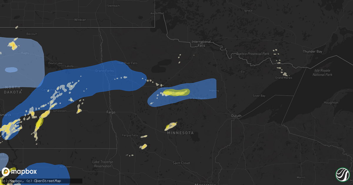
Hail Map on July 26, 2025
Get this storm
July 26 map
$229
one time, instant access
Download today. No call, no setup
Keep the $229
Bought the map and want the full workflow? Apply the entire $229 to a subscription within 7 days. None of it is wasted.
Every map, not just this one
This buys you this map. Subscription and you get every map we run, in the markets you choose from a few cities to whole states to nationwide. Plus real-time alerts the moment a storm fires.
Contact data
Name, contact info, occupancy, even credit band for addresses in the footprint. You go from where it hit to who to call.
Become the source they trust
Unlimited branding weather history reports on demand. You already have the documented answer ready for the property owner, and you are the one who showed up with it.
Property data and RoofTrace estimates
Pull up any address you have got, its value and the exact code rules for that jurisdiction, straight from One Click Code. Then RoofTrace estimates the squares, pitch, and roof value, priced the way you price.
States Impacted by Hail Map on July 26, 2025
Storm reports
Idaho
| Date | Description |
|---|---|
| 07/26/20254:21 PM CDT | Kllj challis airport. |
| 07/25/202510:00 PM CDT | Homedale police department reports down power lines in betty uda park. |
| 07/25/20259:30 PM CDT | Tree fell on chicken coop. Power outages. |
| 07/25/20259:30 PM CDT | Large tree fell... With damage to house. |
| 07/25/20258:30 PM CDT | Tree on house. |
Nebraska
| Date | Description |
|---|---|
| 07/26/20256:05 PM CDT | Time estimated from radar. |
Montana
| Date | Description |
|---|---|
| 07/26/20256:46 PM CDT | Asos station kbtm butte-mooney ap. |
| 07/26/20255:00 PM CDT | Mesonet station gw0007 big timber. |
| 07/26/20251:45 AM CDT | Asos station kbhk baker. |
| 07/26/20251:18 AM CDT | Poplar raws station. |
| 07/26/20251:03 AM CDT | Jordan airport. |
| 07/26/202512:47 AM CDT | Poplar municipal airport. |
| 07/26/202512:45 AM CDT | Corrects previous tstm wnd gst report from 5 nnw poplar. Poplar north |
| 07/26/202512:35 AM CDT | Poplar north |
| 07/26/202512:16 AM CDT | Asos station kolf wolf point airport. |
| 07/25/202510:12 PM CDT | 31g59 king coulee... Mt |
| 07/25/202510:12 PM CDT | Corrects previous tstm wnd gst report from 2 wnw jordan. 40g64 jordan... Jordan airport... Mt |
| 07/25/20259:36 PM CDT | 26g68 south sawmill creek... Mt |
| 07/25/20258:55 PM CDT | Video on social media. |
| 07/25/20258:12 PM CDT | Photo on social media show hailstones with a quarter showing max hail size of 2.75 inches. |
| 07/25/20258:09 PM CDT | Asos station kmso missoula... Mt. |
Indiana
| Date | Description |
|---|---|
| 07/26/20255:12 PM CDT | Trw winds estimated at 60 mph. |
| 07/26/20252:20 PM CDT | Photo on facebook of a large tree down between two homes near the intersection of 12th and elm street in rochester. No injuries. Time estimated via radar. |
| 07/26/20251:55 PM CDT | Photo on facebook of several large tree limbs down in culver. Time estimated via radar. |
| 07/25/20257:07 PM CDT | 4 large trees snapped and several limbs down in the 3900 block of east treaty line rd near boundary city. Time estimated via radar. |
| 07/25/20257:06 PM CDT | Barn damaged at the intersection of s 200 e and e 650 s near boundary city. Several metal roof pieces were ripped from the east side of the barn and thrown backwards to |
| 07/25/20257:06 PM CDT | A few small tree limbs down and several pieces of metal lofted into nearby corn fields near the intersection of s 200 e and e 650 s. Time estimated via radar. |
Ohio
| Date | Description |
|---|---|
| 07/26/20256:07 PM CDT | Public safety scanner reported a tree limb down across beechgrove road between hieber road and spore brandywine road. Time estimated via ra |
| 07/26/20256:07 PM CDT | Public safety scanner reported a tree limb down across beechgrove road between hieber road and spore brandywine road. Time estimated via radar. |
| 07/26/20256:07 PM CDT | Publi |
| 07/26/20256:05 PM CDT | Public safety scanner reported tree limbs and power lines down on state route 4 near quaintance road. Time estimated via radar. |
| 07/26/20256:05 PM CDT | Public safety scanner reported tree limbs and power lines down on state route 4 ne |
| 07/26/20255:45 PM CDT | Two trees down. Damage to siding on house and garage. |
| 07/25/202510:00 PM CDT | Several trees blown down. |
| 07/25/20258:05 PM CDT | A large tree was downed over biggert road. |
Michigan
| Date | Description |
|---|---|
| 07/26/20253:18 PM CDT | Delayed report from sanilac county em and michigan state police. A barn was damaged along with superficial damage to a home. |
Minnesota
| Date | Description |
|---|---|
| 07/26/20256:59 AM CDT | Spotter reports 3 large trees |
| 07/26/20256:59 AM CDT | Spotter reports 3 large trees down along with numerous large branches in town. Some minor street flooding as well. |
| 07/26/20256:57 AM CDT | Multiple healthy large tree branches |
| 07/26/20256:57 AM CDT | Multiple healthy large tree branches down and one tree trunk snapped within a couple blocks radius. Time estimated from rad |
| 07/26/20256:57 AM CDT | Multiple healthy l |
| 07/26/20256:57 AM CDT | Multiple healthy large tree branches down and one tree trunk snapped within a couple blocks radius. Time estimated from radar. |
| 07/26/20256:57 AM CDT | Multiple healthy large tree branches down and one tree trunk snapped within a coup |
| 07/26/20256:50 AM CDT | Large tree branch snapped. The branch looked somewhat rotten but the tree was healthy. Time estimated from radar. |
| 07/26/20256:30 AM CDT | Multiple trees were uprooted and snapped at the location with at least one on a home and another on a vehicle per photos. Time estimated by radar. |
| 07/26/20256:30 AM CDT | Multiple trees were uprooted and snapped at the location with at least one on a home and another on a vehic |
| 07/26/20255:42 AM CDT | Several large trees snapped and large branches down. |
| 07/26/20252:37 AM CDT | Measured on private weather station. |
| 07/26/20252:33 AM CDT | Measured by ndawn mesonet station. |
South Dakota
| Date | Description |
|---|---|
| 07/26/20256:02 PM CDT | A local report indicates 1.25 inch wind near 11 W Mission Ridge |
| 07/26/20252:10 AM CDT | Mesonet station 178 trail city |
| 07/26/20252:10 AM CDT | Mesonet station grrs2 bullhead 10 s peak gust. Time estimated |
| 07/26/20252:06 AM CDT | Mesonet station grrs2 bullhead 10 s. Decaying thunderstorm heat burst. |
| 07/26/20251:45 AM CDT | Mesonet station tims2 timber lake |
| 07/25/202510:47 PM CDT | A local report indicates 1.75 inch wind near 9 W Hereford |
| 07/25/202510:10 PM CDT | Mesonet station hihs2 highm |
| 07/25/202510:10 PM CDT | Mesonet station hihs2 highmore |
| 07/25/202510:05 PM CDT | Mesonet station 215 polo 17 w jct sd47/sd26 |
| 07/25/202510:05 PM CDT | Mesonet station hihs2 highmore |
| 07/25/202510:05 PM CDT | Mesonet station hmms2 highmore 23n |
| 07/25/202510:05 PM CDT | Mesonet statio |
| 07/25/202510:00 PM CDT | Mesonet station 13 vivian |
| 07/25/202510:00 PM CDT | Mesonet station 19 harrold |
| 07/25/20259:46 PM CDT | Mesonet station 325 seneca 5w |
| 07/25/20259:44 PM CDT | A local report indicates 60 MPH wind near 1 NE Winner |
| 07/25/20259:30 PM CDT | A local report indicates 60 MPH wind near 1 NE Midland |
| 07/25/20259:25 PM CDT | A local report indicates 83 MPH wind near 9 ENE Belvidere |
| 07/25/20259:15 PM CDT | A local report indicates 1.00 inch wind near 16 N Belle Fourche |
| 07/25/20259:00 PM CDT | A local report indicates 58 MPH wind near 10 NNW Ottumwa |
| 07/25/20258:55 PM CDT | A local report indicates 89 MPH wind near 9 ENE Belvidere |
| 07/25/20258:50 PM CDT | Heatburst |
| 07/25/20257:45 PM CDT | A local report indicates 62 MPH wind near 1 S White River |
| 07/25/20257:30 PM CDT | Hail occurred for a couple of minutes. |
| 07/25/20257:29 PM CDT | A local report indicates 1.75 inch wind near 8 N Vetal |
| 07/25/20257:15 PM CDT | Sdsu site at gettysburg w. |
Texas
| Date | Description |
|---|---|
| 07/26/20255:35 PM CDT | A local report indicates 63 MPH wind near 3 W Goodlett |
| 07/25/20259:35 PM CDT | An off-duty nws employee reported a severe downburst wind gust near gardendale. The maximum wind speed is estimated. |
| 07/25/20257:25 PM CDT | A local report indicates 59 MPH wind near 1 E Crowell |
Nevada
| Date | Description |
|---|---|
| 07/26/20256:10 PM CDT | [landspout] media relayed a video from the public of a tall and narrow landspout near stagecoach... Nv just after 4 pm. |
Maryland
| Date | Description |
|---|---|
| 07/25/20257:15 PM CDT | Several trees and wires blew down between lonaconing and cumberland... Including on arch street and dan's mountain. |
Wyoming
| Date | Description |
|---|---|
| 07/26/20256:52 PM CDT | Mesonet station hhrw4 hyattville 5 ene. |
West Virginia
| Date | Description |
|---|---|
| 07/26/20254:41 PM CDT | Pole down with power lines across road on left fork kites run road. |
| 07/26/20252:31 PM CDT | Tree down onto powerlines near the intersection of brucetown road and happy creek drive. |
| 07/26/20252:31 PM CDT | Three trees down along brucetown rd. |
| 07/26/20252:31 PM CDT | Tree down onto power lines near the 800 block of hidden hollow drive. |
| 07/26/20252:20 PM CDT | Corrects previous tstm wnd dmg report from 5 ene mineral wells. Pole down with power lines across road on left fork kites run road. Time estimated by radar. |
| 07/26/20252:09 PM CDT | Tree damage resulting in approximately 20 customers without power. Time is estimated by radar. |
| 07/26/20252:08 PM CDT | Trees down in and around martinsburg. |
| 07/26/20251:59 PM CDT | A few trees down near hedgesville. |
| 07/26/20251:40 PM CDT | State doh reports a tree down on larkmead rd near lemon lane. Time estimated from radar. |
| 07/26/20251:27 PM CDT | Tree down near the intersection of dewdrop lane and audubon rd. |
Pennsylvania
| Date | Description |
|---|---|
| 07/26/20255:22 PM CDT | Images show snapped trees along mcgrady hollow road east of butler. Time estimated based on radar. |
| 07/26/20255:20 PM CDT | Report of multiple trees and power lines down in middlesex township. Time estimated based on radar. |
| 07/26/20255:18 PM CDT | Report of trees down on wires along logan road. Time estimated based on radar. |
| 07/26/20255:18 PM CDT | Reports of multiple trees and power lines down in the area. Time estimated based on radar. |
| 07/26/20255:16 PM CDT | Report of tree down along bonniebrook road near the route 422. Time estimated based on radar. |
| 07/26/20255:09 PM CDT | Report of trees down on wires along hamel road. Time estimated based on radar. |
| 07/26/20254:56 PM CDT | Public safety scanner reported a tree down and blocking state highway 27 between moyer road south wayland road. Time estimated via radar. |
| 07/26/20254:45 PM CDT | Public safety scanner reported a tree and wires down on tamarack drive. Time estimated via radar. |
| 07/26/20254:38 PM CDT | Public safety scanner reported a tree down on atlantic lake road near west calvin road. Time estimated via radar. |
| 07/26/20254:37 PM CDT | Report of a tree down along cramer road. Time estimated on radar. |
| 07/26/20254:37 PM CDT | Report of a utility line down along newport road. Time estimated based on radar. |
| 07/26/20254:36 PM CDT | Report of trees down along lewisville road. Time estimated based on radar. |
| 07/26/20254:15 PM CDT | Several trees and wires down around atlantic. Time estimated via radar. |
| 07/26/20251:03 PM CDT | Trees and wires down on maddesnsville pike. |
| 07/26/202512:08 PM CDT | Trees down on us22... William penn highway. |
| 07/26/202511:07 AM CDT | Tree... Wires... And power pole down on tipton manor rd. |
| 07/25/20257:20 PM CDT | Trees down across the roadway blocking the road. |
North Dakota
| Date | Description |
|---|---|
| 07/26/20256:00 AM CDT | Nddot wind sensor. |
| 07/26/20255:53 AM CDT | Awos station k5h4 harvey nd awos. |
| 07/26/20255:35 AM CDT | A public report of 70 mph wind gusts and 2.1 inches of rain. |
| 07/26/20255:30 AM CDT | Nddot wind sensor. |
| 07/26/20255:28 AM CDT | Ndawn mesonet site. |
| 07/26/20255:22 AM CDT | Image shared via social media of damage to the roof of a metal shop 5 north of balfour. |
| 07/26/20255:18 AM CDT | Ndawn mesonet site 2 n karlsruhe. |
| 07/26/20255:15 AM CDT | A local report indicates 60 MPH wind near 2 SSW Minot |
| 07/26/20255:10 AM CDT | Social media reports of large grain bins being damaged and one completely knocked down in voltaire. |
| 07/26/20255:07 AM CDT | 10 m wind gust at ndawn station benedict 4 se. |
| 07/26/20255:05 AM CDT | Broadcast media shared photos a viewer sent in of wind damage in velva. The damage was caused by a metal out building blowing into a multi family home causing damage to |
| 07/26/20255:01 AM CDT | 10 m wind gust at ndawn station sawyer 7 s. |
| 07/26/20254:59 AM CDT | 10 m wind gust at ndawn station sawyer 7 s. |
| 07/26/20254:54 AM CDT | 10 m wind gust at ndawn station benedict 4 se. |
| 07/26/20254:50 AM CDT | Facebook post showing a large tree snapped in half and large tree branches also snapped off. |
| 07/26/20254:50 AM CDT | 10 m wind gust at ndawn station benedict 4 se. |
| 07/26/20254:50 AM CDT | Corrects previous tstm wnd dmg report from benedict. Facebook post showing a large tree snapped in half and large tree branches also snapped off. Estimated wind gusts 6 |
| 07/26/20254:49 AM CDT | Asos station kmot minot airport. |
| 07/26/20254:48 AM CDT | 10 m wind gust at ndawn station max 3 n. |
| 07/26/20254:38 AM CDT | Awos station k1dn 1 s max. |
| 07/26/20254:27 AM CDT | Asos station kn60 garrison. |
| 07/26/20254:06 AM CDT | 10 m wind gust at ndawn station pick city 8 sw. |
| 07/26/20254:00 AM CDT | Mesonet station fw7163 raub. |
| 07/26/20254:00 AM CDT | Public social media report of a garage being blown apart with some down tree branches. |
| 07/26/20253:53 AM CDT | Nddot wind sensor. Time estimated from radar. |
| 07/26/20253:53 AM CDT | 10 m wind gust at ndawn station zap 11 n. |
| 07/26/20253:44 AM CDT | 10 m wind gust at ndawn station zap 11 n. |
| 07/26/20253:35 AM CDT | Awos station kd57 glen ullin. |
| 07/26/20253:30 AM CDT | Social media report of a roof being ripped off a trailer home 4 miles east of twin buttes. |
| 07/26/20253:18 AM CDT | Wind gust measured by a personal weather station. Report relayed by emergency management. |
| 07/26/20253:16 AM CDT | 10 m wind gust at ndawn station hebron 7 s. |
| 07/26/20253:09 AM CDT | 10 m wind gusts at ndawn station manning 4 sw. |
| 07/26/20253:09 AM CDT | Facebook post. |
| 07/26/20253:00 AM CDT | Nddot wind sensor. |
| 07/26/20252:51 AM CDT | 10 m wind gust at ndawn station ray 4 n. |
| 07/26/20252:46 AM CDT | Wind gust measured by a personal weather station. Report relayed by emergency management. |
| 07/26/20252:46 AM CDT | Social media reports of damage to the roof of a business in belfield. |
| 07/26/20252:42 AM CDT | Facebook post showing metal roofing partially torn off a building. |
| 07/26/20252:20 AM CDT | Twelve inch diamter tree down on roof of house. |
| 07/26/20252:20 AM CDT | Measured 10 meter wind gust at ndawn station new england 5w. |
| 07/26/20252:20 AM CDT | Photo of large tree branches snapped via social media. Time estimated via radar. |
| 07/26/20252:19 AM CDT | A local report indicates 62 MPH wind near 2 SE Thompson |
| 07/26/20252:16 AM CDT | Asos station kgfk grand forks ap nd. |
| 07/26/20252:10 AM CDT | Wind gust recorded by ndawn station. |
| 07/26/20252:07 AM CDT | Ndawn station reporting 10 m winds. |
| 07/26/20251:59 AM CDT | Gf afb measured gust. |
| 07/26/20251:55 AM CDT | Mesonet station 321480 6 nnw charbonneau |
| 07/26/20251:49 AM CDT | Gust measured from private weather station. |
| 07/26/20251:33 AM CDT | Damage to several outbuildings. Lean to roof blown off. Several rafters of 40 by 60 outbuilding damaged in open doorway. Time estimated by radar. |
| 07/26/202512:38 AM CDT | 10 meter measured wind gust at ndawn station courtenay 5w. 53 mph gust at 3 meters. |
| 07/26/202512:16 AM CDT | Measured wind gust at private weather station. |
| 07/26/202512:04 AM CDT | Personal weather station 1 e of pettibone. |
| 07/25/202510:38 PM CDT | Pea sized hail and a few quarter size hail was reported from social media. |
Oregon
| Date | Description |
|---|---|
| 07/25/20259:00 PM CDT | Thunderstorm wind gust broke a tree limb and snapped a power pole. |
| 07/25/20258:56 PM CDT | A local report indicates 67 MPH wind near 2 WSW Ontario |
| 07/25/20258:48 PM CDT | Kono airport. |
Virginia
| Date | Description |
|---|---|
| 07/26/20256:59 PM CDT | Two trees down in rockfish gap. |
| 07/26/20256:43 PM CDT | Trees and wires blew down in the 700 block of dooms crossing road. |
| 07/26/20255:30 PM CDT | Trees blew down on va-731 natural chimney road. |
| 07/26/20254:24 PM CDT | Tree down onto roadway on reva rd. |
| 07/26/20253:44 PM CDT | Tree down near the intersection of sperryville pike and f.t valley road. |
| 07/26/20253:44 PM CDT | Several trees down in sperryville |
| 07/26/20253:44 PM CDT | Several trees down in sperryville |
Cities Impacted by Hail Map on July 26, 2025
- Epping, ND
- Ray, ND
- White Earth, ND
- Tioga, ND
- Stanley, ND
- New Town, ND
- Ross, ND
- Watford City, ND
- Middletown, IL
- Elkhart, IL
- New Holland, IL
- Lincoln, IL
- Stanford, IL
- Atlanta, IL
- Delavan, IL
- Minier, IL
- Hartsburg, IL
- Emden, IL
- Armington, IL
- McLean, IL
- Bloomington, IL
- Danvers, IL
- Clinton, IL
- Beason, IL
- Shirley, IL
- Kenney, IL
- Mount Pulaski, IL
- Waynesville, IL
- Chestnut, IL
- Lawndale, IL
- Heyworth, IL
- Wapella, IL
- Lexington, IL
- Towanda, IL
- Normal, IL
- Hudson, IL
- Ellsworth, IL
- Downs, IL
- Le Roy, IL
- Cooksville, IL
- Clitherall, MN
- Vining, MN
- Battle Lake, MN
- Henning, MN
- Herman, MN
- Donnelly, MN
- Brandon, MN
- Evansville, MN
- Garfield, MN
- Alexandria, MN
- Shade Gap, PA
- Neelyton, PA
- Orbisonia, PA
- Three Springs, PA
- Berkeley Springs, WV
- Bowling Green, MO
- Willow Hill, PA
- Spring Run, PA
- Orrstown, PA
- Fannettsburg, PA
- Upperstrasburg, PA
- Pleasant Hall, PA
- Louisiana, MO
- Burnt Cabins, PA
- Knox, IN
- North Judson, IN
- Monterey, IN
- Ora, IN
- Hedgesville, WV
- Rensselaer, IN
- Harrisonville, MO
- Peculiar, MO
- Bennington, OK
- Martinsburg, WV
- Gerrardstown, WV
- Inwood, WV
- Walker, WV
- Elizabeth, WV
- Rochester, IN
- Kewanna, IN
- Lockney, TX
- Bunker Hill, WV
- Kearneysville, WV
- Fort Wayne, IN
- Summit Point, WV
- Maple Hill, NC
- Charles Town, WV
- South Vienna, OH
- South Charleston, OH
- Coldwater, OH
- Matador, TX
- Montezuma, OH
- Celina, OH
- Vega, TX
- Huntington, IN
- Columbia City, IN
- Sperryville, VA
- Silas, AL
- Saint Henry, OH
- Roanoke, IN
- Woodville, VA
- Childress, TX
- Lyman, NE
- Grand Marais, MN
- Paola, KS
- Saint Francis, SD
- Walsh, CO
- Silverton, TX
- Floydada, TX
- Converse, IN
- Marion, IN
- Faunsdale, AL
- Port Hope, MI
- Hay Springs, NE
- Clarence, MO
- Kinde, MI
- Hereford, TX
- Linden, AL
- Rushville, NE
- Mcadoo, TX
- Campo, CO
- Hemingford, NE
- Martinsville, IN
- Monrovia, IN
- Quincy, IN
- Stilesville, IN
- Clayton, IN
- Mooresville, IN
- Corn, OK
- Divernon, IL
- Glenarm, IL
- Auburn, IL
- Urbana, OH
- Two Dot, MT
- Carter, MT
- Brady, MT
- Mount Solon, VA
- Butler, PA
- Valencia, PA
- Gravois Mills, MO
- Millry, AL
- Mount Sidney, VA
- Staunton, VA
- Bridgeport, NE
- Bayard, NE
- Eutaw, AL
- Cloverdale, IN
- Mars, PA
- Angora, NE
- Verona, VA
- Weatherford, OK
- Stover, MO
- Edwards, MO
- Versailles, MO
- Fort Pierre, SD
- Hayes, SD
- Eagle Butte, SD
- Richfield, KS
- Hobson, MT
- Geyser, MT
- Ryegate, MT
- Haxtun, CO
- Owingsville, KY
- Gordon, NE
- Merriman, NE
- Saco, MT
- Hinsdale, MT
- Nelson, MO
- Colony, OK
- Alliance, NE
- Martin, SD
- Rolla, KS
- Shawmut, MT
- Fort Defiance, VA
- Crowell, TX
- Lavina, MT
- Santo, TX
- West Jefferson, OH
- Palo Pinto, TX
- Murphy, ID
- London, OH
- Waynesboro, VA
- Paducah, TX
- Palmyra, PA
- Norris, SD
- Lewistown, MT
- Buffalo, MT
- New Philadelphia, OH
- Ovid, CO
- Glasgow, MT
- Crozet, VA
- Lithopolis, OH
- Canal Winchester, OH
- Groveport, OH
- Roundup, MT
- Columbus, OH
- Lockbourne, OH
- Timber Lake, SD
- Trail City, SD
- Marsing, ID
- Homedale, ID
- Tuthill, SD
- Larslan, MT
- Long Valley, SD
- Hays, MT
- Dodson, MT
- Malta, MT
- Nashua, MT
- Fleming, CO
- Midland, SD
- Quanah, TX
- Turner, MT
- Hogeland, MT
- Hulett, WY
- Broadwater, NE
- Marshall, MO
- El Dorado Springs, MO
- Moore, MT
- Annville, PA
- Lebanon, PA
- Manheim, PA
- Elizabethtown, PA
- White River, SD
- Wood, SD
- Elkhart, KS
- Hilger, MT
- Gettysburg, SD
- Agar, SD
- Selby, SD
- Lebanon, SD
- Hoven, SD
- Bowdle, SD
- Java, SD
- Tolstoy, SD
- Onaka, SD
- Roscoe, SD
- Loring, MT
- Winifred, MT
- Chinook, MT
- Nyssa, OR
- Roy, MT
- Ridgeville, IN
- Ellsworth, NE
- Cascade, MT
- Lloyd, MT
- Ontario, OR
- Sedgwick, CO
- Onida, SD
- Farwell, MN
- Starbuck, MN
- Winnett, MT
- Brusett, MT
- Mosby, MT
- Vale, OR
- Whitewater, MT
- Zortman, MT
- Jordan, MT
- Fort Peck, MT
- Draper, SD
- Okaton, SD
- Murdo, SD
- Kadoka, SD
- Belvidere, SD
- Fort Yates, ND
- Harlem, MT
- Oshkosh, NE
- Selfridge, ND
- Mullen, NE
- Greencastle, PA
- Midland, TX
- Gardendale, TX
- Odessa, TX
- Goldsmith, TX
- Highmore, SD
- Seneca, SD
- Holabird, SD
- Solen, ND
- Wishek, ND
- Linton, ND
- Stanton, TX
- Ashley, ND
- Waynesboro, PA
- Cannon Ball, ND
- Sand Springs, MT
- Orient, SD
- Hyannis, NE
- Springfield, OH
- Farmersville, IL
- Ree Heights, SD
- Lehr, ND
- Hazelton, ND
- Mandan, ND
- Sabillasville, MD
- Cascade, MD
- Smithsburg, MD
- Hagerstown, MD
- Napoleon, ND
- Cohagen, MT
- Tulare, SD
- Redfield, SD
- Faulkton, SD
- Miller, SD
- Rockham, SD
- Saint Lawrence, SD
- Wessington, SD
- Harrold, SD
- Blunt, SD
- Pierre, SD
- Northville, SD
- Cresbard, SD
- Mansfield, SD
- Ipswich, SD
- Ashton, SD
- Hosmer, SD
- Whitman, NE
- Elsberry, MO
- Silex, MO
- Hammond, MT
- Boyes, MT
- Sturgis, SD
- Moffit, ND
- Braddock, ND
- Howes, SD
- Piedmont, SD
- Enning, SD
- New Underwood, SD
- Tappen, ND
- Streeter, ND
- Gackle, ND
- Saint Anthony, ND
- Menoken, ND
- Bismarck, ND
- Driscoll, ND
- Sterling, ND
- Union Center, SD
- Faith, SD
- Julesburg, CO
- Steele, ND
- Circle, MT
- Brockway, MT
- Frazer, MT
- Wolf Point, MT
- White Owl, SD
- Aberdeen, SD
- Mellette, SD
- Warner, SD
- Stratford, SD
- Turton, SD
- Brentford, SD
- Hitchcock, SD
- Medina, ND
- Dawson, ND
- Wing, ND
- Tuttle, ND
- Robinson, ND
- Newell, SD
- Vale, SD
- Cleveland, ND
- Woodworth, ND
- Buchanan, ND
- Venango, NE
- Pingree, ND
- Dupree, SD
- Meadow, SD
- Richey, MT
- Poplar, MT
- Vida, MT
- Bloomfield, MT
- Lambert, MT
- Lindsay, MT
- Bowdon, ND
- Wimbledon, ND
- Spiritwood, ND
- Courtenay, ND
- Pettibone, ND
- Jamestown, ND
- Kensal, ND
- Carrington, ND
- Sykeston, ND
- Valley City, ND
- Shields, ND
- Flasher, ND
- Seneca, NE
- Thedford, NE
- Anselmo, NE
- Oriska, ND
- Rogers, ND
- Dazey, ND
- Stapleton, NE
- Brockton, MT
- Sidney, MT
- Fairview, MT
- Froid, MT
- Culbertson, MT
- Bainville, MT
- Cathay, ND
- New Rockford, ND
- Sheyenne, ND
- Glenfield, ND
- Cooperstown, ND
- Mchenry, ND
- Grace City, ND
- Binford, ND
- Sutton, ND
- Hannaford, ND
- Luverne, ND
- Halsey, NE
- Merna, NE
- Arnold, NE
- Ludlow, SD
- Willow City, ND
- Towner, ND
- Bantry, ND
- Jessie, ND
- Aneta, ND
- Crary, ND
- Warwick, ND
- Mcville, ND
- Michigan, ND
- Lakota, ND
- Tolna, ND
- Oberon, ND
- Saint Michael, ND
- Pekin, ND
- Northwood, ND
- Finley, ND
- Petersburg, ND
- Clifford, ND
- Galesburg, ND
- Portland, ND
- Blanchard, ND
- Hope, ND
- Sharon, ND
- Hatton, ND
- Homestead, MT
- Medicine Lake, MT
- Dagmar, MT
- Williston, ND
- Cartwright, ND
- Bowman, ND
- Annada, MO
- Winchester, IN
- Scranton, ND
- Broken Bow, NE
- Bottineau, ND
- Fairfield, ND
- Amidon, ND
- New England, ND
- Donnybrook, ND
- Powers Lake, ND
- Kenmare, ND
- Alexander, ND
- Grassy Butte, ND
- Medora, ND
- Grenora, ND
- Belfield, ND
- Mohall, ND
- Lefor, ND
- Gladstone, ND
- Dickinson, ND
- Regent, ND
- Crookston, MN
- Richardton, ND
- Taylor, ND
- Maxbass, ND
- Manning, ND
- South Heart, ND
- Eolia, MO
- Mott, ND
- Zahl, ND
- Alamo, ND
- Ambrose, ND
- Trenton, ND
- Crosby, ND
- Mandaree, ND
- Arnegard, ND
- Keene, ND
- Wildrose, ND
- Killdeer, ND
- Sargent, NE
- Red Lake Falls, MN
- Mentor, MN
- Dunn Center, ND
- Halliday, ND
- Hettinger, ND
- Reeder, ND
- Hebron, ND
- Glen Ullin, ND
- New Leipzig, ND
- Niagara, ND
- Larimore, ND
- Emerado, ND
- Mayville, ND
- Arvilla, ND
- Gilby, ND
- Mekinock, ND
- Thompson, ND
- Grand Forks Afb, ND
- Manvel, ND
- Reynolds, ND
- East Grand Forks, MN
- Oslo, MN
- Grand Forks, ND
- Buxton, ND
- Warren, MN
- Fisher, MN
- Euclid, MN
- Nielsville, MN
- Beltrami, MN
- Shelly, MN
- Cummings, ND
- Caledonia, ND
- Climax, MN
- Ada, MN
- Hillsboro, ND
- Fertile, MN
- Thief River Falls, MN
- Saint Hilaire, MN
- Plummer, MN
- Brooks, MN
- Mcintosh, MN
- Fosston, MN
- Bejou, MN
- Winger, MN
- Gary, MN
- Erskine, MN
- Oklee, MN
- McIntosh, SD
- Isabel, SD
- McLaughlin, SD
- Little Eagle, SD
- Glencross, SD
- Wakpala, SD
- Vivian, SD
- Presho, SD
- Philip, SD
- Milesville, SD
- Cherry Creek, SD
- Trail, MN
- Clearbrook, MN
- Gully, MN
- Gonvick, MN
- Mahnomen, MN
- Bagley, MN
- Lengby, MN
- Palermo, ND
- Beulah, ND
- New Salem, ND
- Almont, ND
- Zap, ND
- Roseglen, ND
- Dodge, ND
- Golden Valley, ND
- Columbus, ND
- Noonan, ND
- Mcgregor, ND
- Lignite, ND
- Bowbells, ND
- Parshall, ND
- Berthold, ND
- Plaza, ND
- Garrison, ND
- Ryder, ND
- Hazen, ND
- Ogema, MN
- Leonard, MN
- Des Lacs, ND
- Burlington, ND
- Makoti, ND
- Surrey, ND
- Shevlin, MN
- Minot, ND
- Norwich, ND
- Laporte, MN
- Solway, MN
- Park Rapids, MN
- Granville, ND
- Deering, ND
- Glenburn, ND
- Bemidji, MN
- Lake George, MN
- Cass Lake, MN
- Ponsford, MN
- Akeley, MN
- Longville, MN
- Nevis, MN
- Walker, MN
- Pennington, MN
- Bena, MN
- Deer River, MN
- Minot Afb, ND
- Carpio, ND
- Douglas, ND
- Tolley, ND
- Lansford, ND
- Mercer, ND
- Benedict, ND
- Wolford, ND
- Westhope, ND
- Rugby, ND
- Turtle Lake, ND
- Martin, ND
- Underwood, ND
- Butte, ND
- Goodrich, ND
- York, ND
- Denhoff, ND
- Balta, ND
- Rolette, ND
- Velva, ND
- Coleharbor, ND
- Souris, ND
- Stanton, ND
- Newburg, ND
- Knox, ND
- Anamoose, ND
- Upham, ND
- Ruso, ND
- Fessenden, ND
- Mcclusky, ND
- Voltaire, ND
- Kramer, ND
- Riverdale, ND
- Balfour, ND
- Sawyer, ND
- Esmond, ND
- Max, ND
- Karlsruhe, ND
- Maddock, ND
- Harvey, ND
- Hurdsfield, ND
- Chaseley, ND
- Drake, ND
- Blackduck, MN
- Federal Dam, MN
- Max, MN
- Talmoon, MN
- Remer, MN
- Cohasset, MN
- Grand Rapids, MN
- Marcell, MN
- Bigfork, MN
- Minnewaukan, ND
- Cando, ND
- Mylo, ND
- Bisbee, ND
- Agate, ND
- Leeds, ND
- Motley, MN
- Staples, MN
- Nashwauk, MN
- Goodland, MN
- Calumet, MN
- Coleraine, MN
- Hibbing, MN
- Pengilly, MN
- Bovey, MN
- Marble, MN
- Taconite, MN
- Keewatin, MN
- Cook, MN
- Side Lake, MN
- Chisholm, MN
- Pequot Lakes, MN
- Nisswa, MN
- Pine River, MN