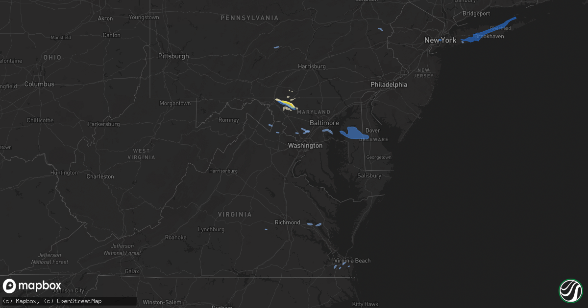
Hail Map in Delaware on August 22, 2019
Get this storm
August 22 map
$229
one time, instant access
Download today. No call, no setup
Keep the $229
Bought the map and want the full workflow? Apply the entire $229 to a subscription within 7 days. None of it is wasted.
Every map, not just this one
This buys you this map. Subscription and you get every map we run, in the markets you choose from a few cities to whole states to nationwide. Plus real-time alerts the moment a storm fires.
Contact data
Name, contact info, occupancy, even credit band for addresses in the footprint. You go from where it hit to who to call.
Become the source they trust
Unlimited branding weather history reports on demand. You already have the documented answer ready for the property owner, and you are the one who showed up with it.
Property data and RoofTrace estimates
Pull up any address you have got, its value and the exact code rules for that jurisdiction, straight from One Click Code. Then RoofTrace estimates the squares, pitch, and roof value, priced the way you price.
Storm reports in Delaware
Delaware
| Date | Description |
|---|---|
| 08/22/20195:11 AM CDT | At 1011 PM EDT, severe thunderstorms were located along a line extending from Millington to near Hartly to Oakland, moving east at 35 mph. HAZARD...70 mph wind gusts and penny size hail. SOURCE...Radar indicated. IMPACT...Expect considerable tree damage. Damage is likely to mobile homes, roofs, and outbuildings. Locations impacted include... Dover, Smyrna, Milford, Harrington, Camden, Clayton, Greensboro, Oakland, Ridgely, Cheswold, Millington, Sudlersville, Bowers, Goldsboro, Woodside, Viola, Hartly, Starr, Hazlettville and Delaney Corner. |
| 08/22/20194:21 AM CDT | At 921 PM EDT, severe thunderstorms were located along a line extending from 6 miles southwest of Newtown to near Bodkin Point to Arnold, moving east at 30 mph. HAZARD...60 mph wind gusts and penny size hail. SOURCE...Radar indicated. IMPACT...Damage to roofs, siding, trees, and power lines is possible. Locations impacted include... Dover, Easton, Centerville, Smyrna, Chestertown, Centreville, Clayton, Greensboro, Oakland, Ridgely, Cheswold, Rock Hall, Church Hill, Millington, Sudlersville, Goldsboro, Queen Anne, Hartly, Old Town and Starr. |
| 08/21/20199:34 PM CDT | Downed tree on kenton road near wimbledon drive. Time estimated from radar. |
All States Impacted by Hail Map on August 22, 2019
Cities Impacted by Hail Map on August 22, 2019
- Ralph, SD
- Colorado Springs, CO
- Hastings, NE
- Shepherd, MT
- Billings, MT
- Huntley, MT
- Buffalo, WY
- Clearmont, WY
- Anadarko, OK
- Apache, OK
- Alda, NE
- Doniphan, NE
- Wood River, NE
- Juniata, NE
- Forsyth, MT
- Pine Bluffs, WY
- Grover, CO
- Carpenter, WY
- Wellston, OK
- Smithsburg, MD
- Rocky Ridge, MD
- Hagerstown, MD
- Thurmont, MD
- Woodsboro, MD
- Sabillasville, MD
- Keymar, MD
- Chandler, OK
- Emmitsburg, MD
- Tecumseh, OK
- Littlestown, PA
- Glasgow, MT
- Macomb, OK
- Yeso, NM
- Cuervo, NM
- Luther, OK
- Otter, MT
- Busby, MT
- Ravenna, NE
- Brule, NE
- Orrtanna, PA
- Raton, NM
- New Raymer, CO
- Fort Sumner, NM
- Glenvil, NE
- Arcadia, OK
- Wanette, OK
- Capulin, NM
- Jones, OK
- Broadus, MT
- Capitol, MT
- Des Moines, NM
- Kimball, NE
- Matador, TX
- Floydada, TX
- Hammond, MT
- Mustang, OK
- Weston, WY
- Whitewater, MT
- Kersey, CO
- Fairfield, PA
- Choctaw, OK
- Asher, OK
- Santa Rosa, NM
- Crosbyton, TX
- Frederick, MD
- Myersville, MD
- Walkersville, MD
- Gettysburg, PA
- Winston Salem, NC
- Union Bridge, MD
- Springer, NM
- Nogales, AZ
- Briggsdale, CO
- Lame Deer, MT
- Arvada, WY
- Saco, MT
- Alzada, MT
- Union City, OK
- Boyes, MT
- Jordan, MT
- Usaf Academy, CO
- Harrah, OK
- Mcloud, OK
- Meeker, OK
- Cyril, OK
- Pauls Valley, OK
- Stratford, OK
- El Reno, OK
- Yukon, OK
- Oklahoma City, OK
- Birney, MT
- Volborg, MT
- Gill, CO
- Edenton, NC
- Tyner, NC
- Knotts Island, NC
- Ballantine, MT
- Worden, MT
- Childress, TX
- Gaithersburg, MD
- Rockville, MD
- Ashton, MD
- Sandy Spring, MD
- Silver Spring, MD
- Olney, MD
- Derwood, MD
- Spencerville, MD
- Fulton, MD
- Brookeville, MD
- Highland, MD
- Burtonsville, MD
- Curtis Bay, MD
- Glen Burnie, MD
- Severn, MD
- Pasadena, MD
- Henderson, MD
- Rock Hall, MD
- Centreville, MD
- Church Hill, MD
- Barclay, MD
- Marydel, MD
- Chestertown, MD
- Felton, DE
- Goldsboro, MD
- Camden Wyoming, DE
- Millington, MD
- Queen Anne, MD
- Ingleside, MD
- Marydel, DE
- Sudlersville, MD
- Greensboro, MD
- Ridgely, MD
- Chesapeake, VA
- Virginia Beach, VA
- Lanexa, VA
- New Kent, VA
- Amelia Court House, VA
- Shacklefords, VA
- Barhamsville, VA
- Hamilton, VA
- Purcellville, VA
- Leesburg, VA
- Ayr, NE
- Blue Hill, NE
- Clay Center, NE
- Edgar, NE
- Fairfield, NE
- Belleville, PA
- Lewistown, PA
- Saylorsburg, PA
- Brodheadsville, PA
- Almyra, AR
- De Witt, AR
- Davidson, OK
- Frederick, OK
- Hollister, OK
- Lyman, SC
- Duncan, SC
- Greer, SC
- Charles Town, WV
- Harpers Ferry, WV
- New York, NY
- Brooklyn, NY
- Jersey City, NJ
- Bellmore, NY
- Wantagh, NY
- Seaford, NY
- West Babylon, NY
- Brentwood, NY
- Bohemia, NY
- Southold, NY
- Laurel, NY
- Smithtown, NY
- Deer Park, NY
- Lindenhurst, NY
- Yaphank, NY
- South Jamesport, NY
- Lake Grove, NY
- Islip Terrace, NY
- West Islip, NY
- Great River, NY
- Shelter Island, NY
- Ronkonkoma, NY
- Centereach, NY
- Patchogue, NY
- Jamesport, NY
- Calverton, NY
- Selden, NY
- Shelter Island Heights, NY
- Massapequa, NY
- Hauppauge, NY
- Babylon, NY
- Cutchogue, NY
- Farmingville, NY
- Islip, NY
- East Islip, NY
- Bay Shore, NY
- Copiague, NY
- Holtsville, NY
- Farmingdale, NY
- Wyandanch, NY
- Oakdale, NY
- Manorville, NY
- Medford, NY
- Brightwaters, NY
- Amityville, NY
- Levittown, NY
- Peconic, NY
- North Babylon, NY
- Greenport, NY
- East Meadow, NY
- Islandia, NY
- Middle Island, NY
- Bethpage, NY
- Wading River, NY
- Central Islip, NY
- Nesconset, NY
- Holbrook, NY
- Mattituck, NY
- Riverhead, NY
- Sayville, NY
- Ridge, NY
- Massapequa Park, NY
- Coram, NY


