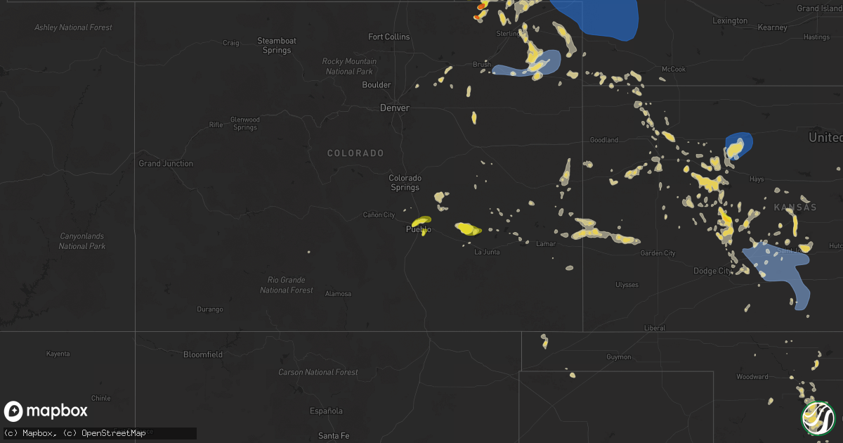
Hail Map on June 13, 2025
Get this storm
June 13 map
$229
one time, instant access
Download today. No call, no setup
Keep the $229
Bought the map and want the full workflow? Apply the entire $229 to a subscription within 7 days. None of it is wasted.
Every map, not just this one
This buys you this map. Subscription and you get every map we run, in the markets you choose from a few cities to whole states to nationwide. Plus real-time alerts the moment a storm fires.
Contact data
Name, contact info, occupancy, even credit band for addresses in the footprint. You go from where it hit to who to call.
Become the source they trust
Unlimited branding weather history reports on demand. You already have the documented answer ready for the property owner, and you are the one who showed up with it.
Property data and RoofTrace estimates
Pull up any address you have got, its value and the exact code rules for that jurisdiction, straight from One Click Code. Then RoofTrace estimates the squares, pitch, and roof value, priced the way you price.
States Impacted by Hail Map on June 13, 2025
Storm reports
Colorado
| Date | Description |
|---|---|
| 06/13/20256:35 PM CDT | A local report indicates 1.00 inch wind near 6 E Wiggins |
| 06/13/20255:10 PM CDT | Landspout tornado confirmed by denver international airport observer as well as trained spotter and public sources. Location is approximate. |
| 06/12/202511:00 PM CDT | Delayed cocorahs report of 1 inch hail. Co-yu-68. |
| 06/12/20258:25 PM CDT | A local report indicates 64 MPH wind near 1 NNW Akron |
| 06/12/20258:05 PM CDT | A local report indicates 61 MPH wind near 1 NNW Akron |
| 06/12/20257:42 PM CDT | A local report indicates 1.00 inch wind near 2 NNW Pueblo |
Kentucky
| Date | Description |
|---|---|
| 06/13/20255:36 PM CDT | Report of a tree blocking the road near the intersection of n ky 32 and george johnson loop. Multiple limbs were reported down in this general area as well. Time is est |
Kansas
| Date | Description |
|---|---|
| 06/13/20256:30 AM CDT | A local report indicates 65 MPH wind near 3 S Pratt |
| 06/13/20256:10 AM CDT | A local report indicates 67 MPH wind near 1 N Macksville |
| 06/13/20254:25 AM CDT | A local report indicates 66 MPH wind near 6 S Palco |
| 06/13/20252:15 AM CDT | Koel in oakley reports 67 mph wind gust. |
| 06/13/202512:38 AM CDT | Site kksoberl22 reports 59 mph wind gust. |
Arkansas
| Date | Description |
|---|---|
| 06/12/20259:13 PM CDT | Strong thunderstorm wind blew down trees. |
| 06/12/20259:11 PM CDT | A local report indicates 1.25 inch wind near 2 SSW Mountainburg |
South Carolina
| Date | Description |
|---|---|
| 06/12/20257:35 PM CDT | Sumter sheriff office reported trees down in dalzell area. Time estimated by radar. |
Texas
| Date | Description |
|---|---|
| 06/13/20256:39 PM CDT | Public report relayed by media. |
| 06/12/202510:26 PM CDT | Mesonet station 96 welch dawson county. |
| 06/12/20259:50 PM CDT | A local report indicates 67 MPH wind near 4 S Levelland |
| 06/12/20259:35 PM CDT | A local report indicates 58 MPH wind near 1 WNW Denver City |
| 06/12/20259:30 PM CDT | A local report indicates 60 MPH wind near 8 SW Sundown |
| 06/12/20259:30 PM CDT | A local report indicates 65 MPH wind near 6 WNW Denver City |
| 06/12/20259:07 PM CDT | A local report indicates 63 MPH wind near 3 N Plains |
| 06/12/20259:01 PM CDT | A local report indicates 64 MPH wind near 4 S Levelland |
| 06/12/20258:53 PM CDT | ( |
| 06/12/20258:53 PM CDT | A local report indicates 64 MPH wind near 1 ENE Morton |
| 06/12/20258:50 PM CDT | A local report indicates 60 MPH wind near 4 S Levelland |
Nebraska
| Date | Description |
|---|---|
| 06/13/20256:49 PM CDT | Kneb broadcaster reported tree damage with pictures of a deciduous tree with numerous branches snapped between 3-4 inches and the largest being 6-8 inches. |
| 06/13/20256:23 PM CDT | Trained spotter reported quarter sized hail in sioux county. |
| 06/13/20255:58 PM CDT | Mping report from a storm chaser via the spotter network of 1.0in hail near melbeta... Ne. |
| 06/12/202510:54 PM CDT | Damage to home relayed from law enforcement. |
| 06/12/202510:51 PM CDT | Power lines reported down. |
| 06/12/202510:50 PM CDT | Koga awos. |
| 06/12/202510:47 PM CDT | Pws-knelemoy4. |
| 06/12/202510:31 PM CDT | Pws-knebigsp27. |
| 06/12/202510:26 PM CDT | Pws-knevenan3. |
| 06/12/202510:23 PM CDT | Pws knebigsp22. |
| 06/12/202510:10 PM CDT | Wind estimated 50 to 60 mph. |
| 06/12/20258:44 PM CDT | Cheyenne county em reported quarte |
| 06/12/20258:44 PM CDT | Cheyenne county em reported quarter size and pea size hail in potter. |
| 06/12/20258:24 PM CDT | Storm chaser reports tornado touch down south of potter around 7:24pm. |
| 06/12/20258:12 PM CDT | Storm chaser reports tornado touching down again. |
| 06/12/20258:09 PM CDT | Storm chaser reports tornado on the ground briefly. Another report suggests intermittent touch downs. |
| 06/12/20258:02 PM CDT | Trained spotter reported quarter sized hail ongoing. |
| 06/12/20257:55 PM CDT | Delayed report. Storm chaser reported brief ground circulation apparent under a funnel. Observer was located nw of potter looking northeast. Distance was unspecified so |
| 06/12/20257:37 PM CDT | Public reports ping pong ball to golf ball sized hail on going. |
Indiana
| Date | Description |
|---|---|
| 06/13/20254:09 PM CDT | Multiple large trees uprooted and fallen onto homes. |
South Dakota
| Date | Description |
|---|---|
| 06/12/20257:05 PM CDT | A local report indicates 1.00 inch wind near 6 SW Edgemont |
Tennessee
| Date | Description |
|---|---|
| 06/13/20255:15 PM CDT | Several trees down. |
| 06/13/20251:16 PM CDT | Trees and tree limbs blown down on alfred martin rd. Time estimated. |
| 06/12/20258:00 PM CDT | Several trees down. |
Montana
| Date | Description |
|---|---|
| 06/13/20255:20 PM CDT | Quarter |
| 06/13/20255:20 PM CDT | Quarter |
| 06/13/20255:20 PM CDT | Time estimated by radar. |
| 06/13/20254:20 PM CDT | A local report indicates 1.50 inch wind near 1 ENE Harlowton |
| 06/13/20254:10 PM CDT | Corrects previous non-tstm wnd dmg report from harlowton. Power lines down with some power outages reported. |
| 06/13/20254:05 PM CDT | [landspout] delayed report: media provided video with approximate time matched to reflectivity. Approximate location based on land features in video from vantage point |
| 06/13/20254:05 PM CDT | Em report of multiple structures with lost roofs... Uprooted trees as well as tree limb damage. |
| 06/13/20254:05 PM CDT | A local report indicates 2.00 inch wind near 4 NE Harlowton |
| 06/12/20259:00 PM CDT | A local report indicates 1.50 inch wind near 1 NNE Busby |
| 06/12/20258:15 PM CDT | A local report indicates 2.00 inch wind near 1 NNW Pryor |
| 06/12/20258:11 PM CDT | Report from mping: tennis ball |
| 06/12/20258:10 PM CDT | A local report indicates 2.75 inch wind near 1 NNW Pryor |
| 06/12/20258:10 PM CDT | A local report indicates 1.00 inch wind near 10 N Hardin |
| 06/12/20258:08 PM CDT | A local report indicates 2.50 inch wind near Pryor |
| 06/12/20257:52 PM CDT | Report from mping: half dollar |
| 06/12/20257:48 PM CDT | A local report indicates 1.50 inch wind near 3 NNE Fox |
| 06/12/20257:45 PM CDT | A local report indicates 1.50 inch wind near 2 NNE Fox |
| 06/12/20257:40 PM CDT | A local report indicates 1.25 inch wind near 1 SW Rockvale |
| 06/12/20257:28 PM CDT | A local report indicates 1.50 inch wind near 6 SE Columbus |
| 06/12/20257:20 PM CDT | Report from mping: golf ball |
| 06/12/20257:16 PM CDT | Tree limbs down and small objects thrown around. |
| 06/12/20257:15 PM CDT | A local report indicates 1.25 inch wind near Columbus |
| 06/12/20257:10 PM CDT | A local report indicates 58 MPH wind near 4 SW Worden |
| 06/12/20257:06 PM CDT | A local report indicates 1.00 inch wind near Columbus |
West Virginia
| Date | Description |
|---|---|
| 06/13/20256:35 PM CDT | Downed tree reported near artrip branch road. Time estimated from radar. |
| 06/12/202511:05 PM CDT | Downed tree reported on cherry fork road. Time estimated from radar. |
| 06/12/20258:51 PM CDT | Tree down on pond fork rd. |
| 06/12/20258:30 PM CDT | Tree down blocking both roadways on missouri fork rd. |
| 06/12/20258:25 PM CDT | Tree down blocking one lane on state st. |
| 06/12/20258:25 PM CDT | Tree down on spruce laurel road. Time estimated by radar. |
| 06/12/20257:56 PM CDT | 4 trees down along band mill hollow rd. |
| 06/12/20257:01 PM CDT | Tree contact resulted in 20 customers without power. |
Virginia
| Date | Description |
|---|---|
| 06/13/20255:55 PM CDT | Large tree limbs blew down in lyndhurst. |
| 06/13/20255:50 PM CDT | Several greenhouses were destroyed at a nursery between lyndhurst and waynesboro. |
| 06/13/20255:45 PM CDT | Trees blew down in the unit block of harvest road. |
| 06/13/20255:45 PM CDT | Trees blew down in the unit block of blackford way. |
| 06/13/20255:44 PM CDT | Trees blew down near the intersection of va-631 ladd road and warren oaks lane. |
| 06/13/20255:43 PM CDT | Trees blew down in the 3600 block of va-624 lyndhurst road. |
| 06/13/20255:39 PM CDT | Numerous trees were knocked down along shalom road. Time estimated from radar. |
| 06/13/20255:23 PM CDT | Trees blew down in the 600 block of sv-865 rockfish road. |
| 06/13/20255:10 PM CDT | Trees blew down in the 600 block of va-782 brower road. |
| 06/13/20255:08 PM CDT | Trees blew down in the 800 block of va-619 hildebrand church road. |
| 06/13/20255:00 PM CDT | Trees blew down on va-782 north point school road in the 200 block. |
| 06/13/20255:00 PM CDT | Corrects previous tstm wnd dmg report from 2 ese hermitage. Trees blew down in the 500 block of oak grove church road. |
| 06/13/20254:52 PM CDT | Trees and wires blew down on forest road in page valley estates. |
| 06/13/20254:50 PM CDT | Trees and wires blew down blocking the 100 block of va-608 battlefield road. |
| 06/13/20254:45 PM CDT | Trees blew down in the 1000 block of balsley road. |
Wyoming
| Date | Description |
|---|---|
| 06/13/20254:51 PM CDT | Observer reported nickel sized hail and wind gusts of 60 mph. |
| 06/12/202511:19 PM CDT | A local report indicates 1.25 inch wind near 6 WNW Wyarno |
Maryland
| Date | Description |
|---|---|
| 06/13/20254:15 PM CDT | Large tree limbs blew down onto wires in beltsville. |
New Mexico
| Date | Description |
|---|---|
| 06/12/20259:25 PM CDT | Mesonet station wsm43 little burro |
| 06/12/20259:25 PM CDT | Mesonet station wsm43 little burro |
| 06/12/20259:10 PM CDT | Mesonet station wsm28 wsmr tula. |
| 06/12/20258:30 PM CDT | Mesonet station wsm12 stallion runway |
Oklahoma
| Date | Description |
|---|---|
| 06/13/20258:23 AM CDT | Asos station klaw lawton. |
Cities Impacted by Hail Map on June 13, 2025
- Indiahoma, OK
- Lawton, OK
- Cache, OK
- Faxon, OK
- Geronimo, OK
- Walters, OK
- Sentinel, OK
- Hobart, OK
- Chattanooga, OK
- Amite, LA
- Roseland, LA
- Loveland, OK
- Roosevelt, OK
- Georgetown, DE
- Millsboro, DE
- Butte, MT
- Laurel, DE
- Whitehall, MT
- Thomaston, AL
- Frankford, DE
- Silsbee, TX
- Toston, MT
- Gilbertown, AL
- Three Forks, MT
- Martinsdale, MT
- Sumter, SC
- Rembert, SC
- Dalzell, SC
- Millport, AL
- Vernon, AL
- Minter, AL
- Belgrade, MT
- Sardis, AL
- Two Dot, MT
- Houston, TX
- Selma, AL
- Conroe, TX
- Sparta, TN
- Wilsall, MT
- Tremont, MS
- Fulton, MS
- Smithville, MS
- Thermopolis, WY
- Kountze, TX
- Jemison, AL
- Thorsby, AL
- Spring, TX
- Douglas, WY
- Garrett, WY
- Judith Gap, MT
- Shawmut, MT
- Navasota, TX
- Harlowton, MT
- Montgomery, TX
- Brenham, TX
- Chappell Hill, TX
- Forest Grove, MT
- Grass Range, MT
- Glendo, WY
- Wheatland, WY
- Big Sandy, MT
- New Hope, AL
- Fort Benton, MT
- Kinnear, WY
- Loma, MT
- Troy, AL
- Verona, VA
- Staunton, VA
- Mount Sidney, VA
- Pavillion, WY
- Manville, WY
- Ryegate, MT
- Chinook, MT
- Winnett, MT
- Crockett, TX
- Conchas Dam, NM
- Garita, NM
- Strunk, KY
- Brighton, CO
- Hudson, CO
- Groveoak, AL
- Roggen, CO
- Havre, MT
- Scottsbluff, NE
- Mitchell, NE
- Lavina, MT
- Magnolia, TX
- Fyffe, AL
- Casper, WY
- Harrison, NE
- Plantersville, TX
- Bucklin, KS
- Wiggins, CO
- Newkirk, NM
- Lusk, WY
- Minatare, NE
- Deer Trail, CO
- Offerle, KS
- Brusett, MT
- McLeod, MT
- Eufaula, AL
- Cuervo, NM
- Brandywine, MD
- Roundup, MT
- Whiteface, TX
- Elida, NM
- Clovis, NM
- Tucumcari, NM
- Council Hill, OK
- Broadview, MT
- Pinehurst, TX
- Shepherd, MT
- Reed Point, MT
- Absarokee, MT
- Balmorhea, TX
- Checotah, OK
- Fort Morgan, CO
- Morton, TX
- Bushnell, NE
- Tomball, TX
- Portales, NM
- Levelland, TX
- Crawford, NE
- Waller, TX
- Bayard, NE
- Columbus, MT
- Kimball, NE
- College Station, TX
- Hemingford, NE
- Joliet, MT
- Somerville, TX
- Burton, TX
- Okmulgee, OK
- Henryetta, OK
- Roswell, NM
- Pueblo, CO
- Ballantine, MT
- Huntley, MT
- Worden, MT
- Billings, MT
- Dalton, NE
- Potter, NE
- Harlem, MT
- Hogeland, MT
- Brush, CO
- Park Hill, OK
- Tahlequah, OK
- Edgemont, SD
- Gillette, WY
- Fayetteville, GA
- Park City, MT
- Pompeys Pillar, MT
- Hardin, MT
- Laurel, MT
- Grady, NM
- Kaycee, WY
- Pep, NM
- Dalhart, TX
- Whitney, NE
- Mcalister, NM
- Dime Box, TX
- New Raymer, CO
- Padroni, CO
- Stoneham, CO
- Hot Springs, SD
- Weston, WY
- Chadron, NE
- Edgar, MT
- Sterling, CO
- Iliff, CO
- Rogers, NM
- Causey, NM
- Bridger, MT
- Lodge Grass, MT
- Pryor, MT
- Sudan, TX
- Maple, TX
- Dix, NE
- Lexington, TX
- Giddings, TX
- Akron, CO
- Otis, CO
- Yoder, CO
- Bridgeport, NE
- Moorcroft, WY
- Hulett, WY
- Fleming, CO
- Lincoln, TX
- Crow Agency, MT
- Alzada, MT
- Broadus, MT
- Colorado Springs, CO
- Boise City, OK
- Hay Springs, NE
- Sidney, NE
- Carmine, TX
- Vici, OK
- Farwell, TX
- Malta, MT
- Stilwell, OK
- Peetz, CO
- Rush, CO
- Yuma, CO
- Rushville, NE
- Uniontown, AR
- Cedarville, AR
- Natural Dam, AR
- Enochs, TX
- Dundee, MS
- Garryowen, MT
- Busby, MT
- Friona, TX
- Rudy, AR
- Chester, AR
- Mountainburg, AR
- Alma, AR
- Seiling, OK
- Tunica, MS
- Bovina, TX
- Crook, CO
- Tatum, NM
- Roberts, MT
- Bighorn, MT
- Round Top, TX
- Lame Deer, MT
- Wray, CO
- Eckley, CO
- Holyoke, CO
- Gordon, NE
- Wagoner, OK
- Hinsdale, MT
- Lovington, NM
- Arapahoe, CO
- Saco, MT
- Gurley, NE
- Loring, MT
- Mulberry, AR
- Florence, TX
- Dimmitt, TX
- Lodgepole, NE
- Cheyenne Wells, CO
- Burlington, CO
- Fort Smith, AR
- Paoli, CO
- Haxtun, CO
- Boone, CO
- Fayetteville, TX
- Hereford, TX
- Birney, MT
- Merriman, NE
- Fairburn, SD
- Oral, SD
- Pine Ridge, SD
- Oshkosh, NE
- Ashby, NE
- Killeen, TX
- Meadow, TX
- Olney Springs, CO
- Wyola, MT
- Colstrip, MT
- Forsyth, MT
- Ordway, CO
- Bingham, NE
- Lonoke, AR
- Cabot, AR
- Chappell, NE
- Pflugerville, TX
- Otter, MT
- Ranchester, WY
- Crowley, CO
- Sheridan, WY
- Big Springs, NE
- Ovid, CO
- Sedgwick, CO
- Julesburg, CO
- Amherst, CO
- Venango, NE
- Champion, NE
- Lewellen, NE
- Brule, NE
- Sugar City, CO
- Rocky Ford, CO
- Ashland, MT
- Martin, SD
- Grant, NE
- Imperial, NE
- Ogallala, NE
- Olive, MT
- Hyannis, NE
- Decker, MT
- Amarillo, TX
- Biddle, MT
- Volborg, MT
- Powderville, MT
- Paxton, NE
- Elsie, NE
- Madrid, NE
- Wauneta, NE
- Enders, NE
- Boyes, MT
- Wallace, NE
- Hayes Center, NE
- Whitman, NE
- Clearmont, WY
- Haigler, NE
- Benkelman, NE
- Parks, NE
- Max, NE
- Stratton, NE
- Eads, CO
- Hasty, CO
- Las Animas, CO
- Hammond, MT
- Valentine, NE
- Bird City, KS
- Saint Francis, KS
- McClave, CO
- Lodgepole, SD
- Atwood, KS
- Wallace, KS
- McDonald, KS
- Holly, CO
- Cody, NE
- Sharon Springs, KS
- Sheridan Lake, CO
- Culbertson, NE
- Tribune, KS
- Winona, KS
- Belle Fourche, SD
- Colby, KS
- Syracuse, KS
- Gem, KS
- Selden, KS
- Monument, KS
- Hoxie, KS
- Rexford, KS
- Jetmore, KS
- Beeler, KS
- Lakin, KS
- Leoti, KS
- Ness City, KS
- Weskan, KS
- Dighton, KS
- Kendall, KS
- Watonga, OK
- Billings, OK
- Oakley, KS
- Hanston, KS
- Vilonia, AR
- Conway, AR
- Bazine, KS
- Fairview, OK
- Deerfield, KS
- Longdale, OK
- Tonkawa, OK
- Red Rock, OK
- Burdett, KS
- Grinnell, KS
- Collyer, KS
- Quinter, KS
- Nardin, OK
- Kinsley, KS
- Gove, KS
- Grainfield, KS
- Utica, KS
- Scott City, KS
- Greenfield, OK
- Sutherland, NE
- Ponca City, OK
- Rozel, KS
- Alexander, KS
- Southard, OK
- Okeene, OK
- Garfield, KS
- Larned, KS
- Park, KS
- Ransom, KS
- Wakeeney, KS
- Canton, OK
- Hitchcock, OK
- Braman, OK
- Blackwell, OK
- Healy, KS
- Nekoma, KS
- Rush Center, KS
- McCracken, KS
- Brownell, KS
- Geary, OK
- Hudson, KS
- St John, KS
- La Crosse, KS
- Hill City, KS
- Kaw City, OK
- Fairfax, OK
- Ralston, OK
- Marland, OK
- Ogallah, KS
- Ellis, KS
- Burbank, OK
- Palco, KS
- Great Bend, KS
- Plainville, KS
- Kingfisher, OK
- Alva, OK
- Bogue, KS
- Russell, KS
- Olmitz, KS
- Ellinwood, KS
- Gorham, KS
- Damar, KS
- Bison, KS
- Stockton, KS
- Aline, OK
- Hoisington, KS
- Pawnee, OK
- Glencoe, OK
- Spearville, KS
- Rose Hill, KS
- Wichita, KS
- Helena, OK
- Carmen, OK
- Hominy, OK
- Udall, KS
- Claflin, KS
- Rock, KS
- Greensburg, KS
- Isabella, OK
- Winfield, KS
- Maramec, OK
- Derby, KS
- Andover, KS
- Valley Center, KS
- Belpre, KS
- Morrison, OK
- Pawnee Rock, KS
- Augusta, KS
- Cherokee, OK
- Benton, KS
- Holyrood, KS
- Protection, KS
- Macksville, KS
- Haviland, KS
- Lewis, KS
- Douglass, KS
- Whitewater, KS
- Newton, KS
- Hunter, OK
- Coldwater, KS
- Pratt, KS
- Iuka, KS
- Lamont, OK
- Lincoln, KS
- Deer Creek, OK
- Medicine Lodge, KS
- Byers, KS
- Turon, KS
- Stafford, KS
- Sawyer, KS
- Isabel, KS
- Sand Springs, OK
- Skiatook, OK
- Prue, OK
- Chester, OK
- Lake City, KS
- Sylvia, KS
- Beverly, KS
- Towanda, KS