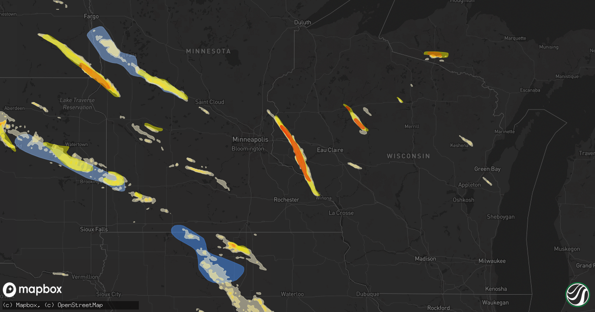
Hail Map on June 19, 2025
Get this storm
June 19 map
$229
one time, instant access
Download today. No call, no setup
Keep the $229
Bought the map and want the full workflow? Apply the entire $229 to a subscription within 7 days. None of it is wasted.
Every map, not just this one
This buys you this map. Subscription and you get every map we run, in the markets you choose from a few cities to whole states to nationwide. Plus real-time alerts the moment a storm fires.
Contact data
Name, contact info, occupancy, even credit band for addresses in the footprint. You go from where it hit to who to call.
Become the source they trust
Unlimited branding weather history reports on demand. You already have the documented answer ready for the property owner, and you are the one who showed up with it.
Property data and RoofTrace estimates
Pull up any address you have got, its value and the exact code rules for that jurisdiction, straight from One Click Code. Then RoofTrace estimates the squares, pitch, and roof value, priced the way you price.
States Impacted by Hail Map on June 19, 2025
Storm reports
New York
| Date | Description |
|---|---|
| 06/19/20256:30 PM CDT | Large tree blocking road on clubhouse rd. |
| 06/19/20254:45 PM CDT | Large tree down and uprooted on bayley place at hayrick lane. |
| 06/19/20254:35 PM CDT | Several large tree branches down across colonial street. |
| 06/19/20254:00 PM CDT | Tree and wires across 60th place/flushing ave in maspeth. |
| 06/19/20253:04 PM CDT | Tree down on babcock lake rd. Time estimated from radar. |
| 06/19/20252:40 PM CDT | Tree down on gifford rd. Time estimated from radar. |
| 06/19/20252:12 PM CDT | Delayed social media report of multiple trees down in millerton. Time estimated from radar. |
| 06/19/20252:08 PM CDT | Large trees down blocking route 44 between millerton and amenia. Time estimated from radar. |
| 06/19/20251:56 PM CDT | Multiple trees down on bangall road. |
| 06/19/20251:40 PM CDT | Downed tree across road at 190 hollow road. |
| 06/18/20258:10 PM CDT | Tree down blocking roadway |
| 06/18/20258:07 PM CDT | Tree down blocking roadway |
Maryland
| Date | Description |
|---|---|
| 06/19/20256:30 PM CDT | Tree fell down along castle hill rd. |
| 06/19/20256:28 PM CDT | Tree fell across forest lane. |
| 06/19/20256:17 PM CDT | Tree fell across wallace taylor rd. |
| 06/19/20256:12 PM CDT | Trees and branches fell on powerlines across brownstone rd. |
| 06/19/20256:10 PM CDT | Tree fell across old princess anne rd. |
| 06/19/20256:08 PM CDT | Multiple trees down along anderson rd. |
| 06/19/20256:05 PM CDT | A tree fell down along silver ln. |
| 06/19/20256:05 PM CDT | Trees fell down on powerlines and caused them to catch fire. |
| 06/19/20255:55 PM CDT | Tree down along henry cross rd. |
| 06/19/20254:40 PM CDT | Multiple trees down at sudlersville cemetery road and higman mill road. Time estimated from radar. |
| 06/19/20254:40 PM CDT | Multiple trees down at sudlersville cemetery road and higman mill road. Time estimated from radar. |
| 06/19/20254:30 PM CDT | Tree on wires at broad and 4th street. Time estimated from radar. |
| 06/19/20254:30 PM CDT | Tree on wires at broad and 4th street. Time estimated from radar. |
| 06/19/20254:27 PM CDT | Large tree limbs downed. |
| 06/19/20254:25 PM CDT | Over a dozen reports of downed trees across southern cecil county from the second round of storms that came thr |
| 06/19/20254:25 PM CDT | Over a dozen reports of downed trees across southern cecil county from the second round of storms that came through. |
| 06/19/20254:25 PM CDT | Tree down near intersection of fairground road and bel alton newtown road. |
| 06/19/20254:23 PM CDT | Tree down. Time estimated from radar. |
| 06/19/20254:20 PM CDT | Multiple trees with wires down along 4h park rd between john brown rd... White house ln... And tilghman neck. Time estimated from radar. |
| 06/19/20254:20 PM CDT | Tree with wires down at double creek rd and evergreen farm ln and mcginnes rd. Time estimated from radar. |
| 06/19/20254:20 PM CDT | Multiple trees with wires down along 4h park rd between john brown rd... White house ln... And tilghman neck. Time estimated from radar. |
| 06/19/20254:11 PM CDT | Eight reports of trees down across northern calvert county. |
| 06/19/20254:10 PM CDT | Several trees uprooted. Time estimated from radar. |
| 06/19/20254:09 PM CDT | Tree with wires down-love point rd. Near kent island high school. Time estimated from radar. |
| 06/19/20254:09 PM CDT | Tree with wires down-love point rd. Near kent island high school. Time estimated from radar. |
| 06/19/20254:06 PM CDT | Trees down across road and on power lines on bayard rd & s polling house rd. |
| 06/19/20254:02 PM CDT | Trees down across road and on power lines on severn way & grandview rd. |
| 06/19/20254:02 PM CDT | Corrects previous tstm wnd dmg report from 1 ssw arnold. Trees down across road and on power lines on severn way & grandview rd. |
| 06/19/20253:57 PM CDT | Trees and wires down... Fully blocked roadway at hazel trail & kyle rd. |
| 06/19/20253:57 PM CDT | Trees down blocking the roadway at virginia ave & our pl. |
| 06/19/20253:52 PM CDT | Trees down in roadway... Fully blocked at drum ave n & christy rd. |
| 06/19/20253:52 PM CDT | Trees down on roadway at willow tree dr & high oak rd. |
| 06/19/20253:51 PM CDT | Trees and wires down with roadway closed on arundel beach road and woodland road. |
| 06/19/20253:50 PM CDT | Five trees blew down near the intersection of chesterfield road and hawkins road. |
| 06/19/20253:50 PM CDT | Several tree branches down near intersection of 4th avenue and crain hwy |
| 06/19/20253:50 PM CDT | Trees blew down on md-43 white marsh boulevard at perry hall boulevard. |
| 06/19/20253:50 PM CDT | Trees blew down on md-2 governor ritchie highway at cypress cove road. |
| 06/19/20253:48 PM CDT | Tree down and pole split in half on evergreen road at oak view drive. |
| 06/19/20253:47 PM CDT | Tree fell onto house causing some structural damage to the corner of the house on walnut trail at n riverside dr. |
| 06/19/20253:45 PM CDT | Trees blew down on md-424 davidsonville road at governor bridge road. |
| 06/19/20253:43 PM CDT | Large branches reported down on central ave near paxtuent river road. |
| 06/19/20253:40 PM CDT | Trees blew down on md-4 pennsylvania avenue between md-980d ritchie marlboro road and old crain highway. |
| 06/19/20253:40 PM CDT | Nws storm survey confirmed an ef-0 tornado briefly touched down in odenton... Md at approximately 440 pm... With peak winds estimated at 80mph. Path length was 0.1 mile |
| 06/19/20253:40 PM CDT | Trees blew down on md-197 collington road near us-301 crain highway. |
| 06/19/20253:40 PM CDT | Over a dozen reports of trees down across the northern portion of cecil county from the first storm that came through. |
| 06/19/20253:40 PM CDT | Numerous trees blew down near the interchange of us-301 crain highway and md-214 central avenue. |
| 06/19/20253:40 PM CDT | Trees blew down on southbound us-301 crain highway at leeland road. |
| 06/19/20253:35 PM CDT | Trees blew down on md-193 enterprise road at chantilly lane. |
| 06/19/20253:35 PM CDT | Trees blew down on us-50 john hanson highway at md-197 collington road. |
| 06/19/20253:34 PM CDT | Westbound suitland pkwy at naylor rd closed due to trees down blocking highway. |
| 06/19/20253:34 PM CDT | Tree down at the intersection suitland parkway and naylor road. |
| 06/19/20253:34 PM CDT | Tree down on a road in bowie |
| 06/19/20253:30 PM CDT | Trees blew down on southbound us-29 at exit 25a/southbound i-70. Trees blew down on md-144 frederick road at starhill lane. |
| 06/19/20253:26 PM CDT | Numerous trees and wires down across silver spring |
| 06/19/20253:25 PM CDT | A wind gust of 51 knots |
| 06/19/20253:25 PM CDT | Trees blew down near the intersection of suitland parkway and md-5 branch avenue. |
| 06/19/20253:24 PM CDT | Tree on a house at the 1600 noyes dr near 2nd ave |
| 06/19/20253:24 PM CDT | Tree down in 5900 block of river road. |
| 06/19/20253:20 PM CDT | Trees and wires down |
| 06/19/20253:20 PM CDT | Tree on a house at the 7900 block of tacoma ave |
| 06/19/20253:20 PM CDT | Tree on a house at the 11300 block of palisades ct |
| 06/19/20253:20 PM CDT | Large tree down at the 1620 block of western ave |
| 06/19/20253:20 PM CDT | Wires down at the 3600 block of spurell ct. |
| 06/19/20253:20 PM CDT | Trees and wires down on a vehicle |
| 06/19/20253:20 PM CDT | Trees blew down on us-29 columbia pike near industrial parkway. |
| 06/19/20253:19 PM CDT | Several small branches... Around 2 inches in diameter... Down in the area |
| 06/19/20253:18 PM CDT | Tree down on a house. |
| 06/19/20253:16 PM CDT | Tree on a house at the 6200 block of vorlich ln |
| 06/19/20253:15 PM CDT | A tree blew down onto a house in the 7900 block of takoma avenue. |
| 06/19/20253:15 PM CDT | Trees and large tree limbs blew down onto power lines in silver spring. |
| 06/19/20253:15 PM CDT | A tree blew down onto a house in the 1600 block of noyes drive |
| 06/19/20253:15 PM CDT | Trees blew down on eastbound i-495 capital beltway inner loop at md-355 wisconsin avenue/rockville pike. |
| 06/19/20253:15 PM CDT | Trees blew down on md-646 prospect road at bay road. |
| 06/19/20253:15 PM CDT | Trees blew down on eastbound i-495 capital beltway inner loop at exit 33/md-185 connecticut avenue... And on westbound i-495 capital betlway outer loop at exit 36/md-18 |
| 06/19/20253:15 PM CDT | Trees blew down on md-543 ady road at walters mill road. |
| 06/19/20253:15 PM CDT | A large tree blew down onto a metro bus near the intersection of md-410 east-west highway and md-185 connecticut avenue. |
| 06/19/20253:14 PM CDT | Trees and wires down |
| 06/19/20253:14 PM CDT | Right lane of clara barton pkwy heading toward i-495 closed due to a tree down |
| 06/19/20253:10 PM CDT | A tree blew down onto a house in the 11000 block of home place lane. |
| 06/19/20253:10 PM CDT | Part of clara barton parkway is blocked by a tree in the direction of i-495. |
| 06/19/20253:10 PM CDT | Trees blew down on southbound i-83 at exit 18/md-943 warren road. |
| 06/19/20253:07 PM CDT | Numerous reports of trees reported down in the jarrettsville area. |
| 06/19/20253:07 PM CDT | National park service reports that the entrance to great fall national park maryland side is blocked by trees. |
| 06/19/20253:05 PM CDT | Trees blew down on eastbound clara barton parkway near i-495 capital beltway. |
| 06/19/20253:05 PM CDT | Trees blew down on southbound i-495 capital beltway outer loop after md-190 river road. |
| 06/19/20253:05 PM CDT | Numerous large trees blew down along md-190 river road between falls road and i-495 capital beltway. |
| 06/19/20253:00 PM CDT | Trees blew down on md-146 jarrettsville pike at dulaney valley road. |
| 06/19/20253:00 PM CDT | Trees blew down near the intersection of md-23 norrisville road and white hall road. |
| 06/19/20252:59 PM CDT | Trees and wires down at whites ferry rd at darnestown rd |
| 06/19/20252:55 PM CDT | Trees blew down on md-45 york road at gifford lane. |
| 06/19/20252:53 PM CDT | Few large trees down onto roadway near intersection of md rt 26 and klee mill rd |
| 06/19/20252:45 PM CDT | Numerous trees blew down along md-25 falls road near knox avenue and shawan road. |
| 06/19/20252:45 PM CDT | Trees blew down on md-25 falls road near benso district of columbdc 3888 7703 tree reported down on ohio drive between buckeye drive and golf course entranc |
| 06/19/20252:45 PM CDT | Trees blew down on md-25 falls road at md-88 black rock road. |
| 06/19/20252:45 PM CDT | Trees blew down on md-25 falls road near benson mill road. |
| 06/19/20252:40 PM CDT | Trees blew down on md-91 emory road at springhurst court. |
| 06/19/20252:29 PM CDT | Large trees blew down along va-407 marston road. |
| 06/19/20252:29 PM CDT | Large trees blew down along va-407 marston |
| 06/19/20252:25 PM CDT | Numerous trees blew down along md-26 liberty road between franklinville road and woodbine road. |
| 06/19/20252:25 PM CDT | Multiple large tree limbs snapped along watersville road. |
| 06/19/20252:23 PM CDT | A couple trees down in adamstown. |
| 06/19/20252:15 PM CDT | Reports of multiple trees down in new market. |
| 06/19/20252:05 PM CDT | Reports of multiple trees down in frederick. |
| 06/19/20252:00 PM CDT | Trees blew down on us-40 alternate/old national pike at south clifton road. |
| 06/19/20252:00 PM CDT | Multiple reports of trees down in jefferson area of frederick county. |
| 06/19/20251:54 PM CDT | A couple calls for trees down in myersville and middletown. |
| 06/19/20251:54 PM CDT | A couple calls for trees down in myersville and middletown. |
| 06/19/20251:50 PM CDT | Trees blew down on petersville road at burkittsville road. N rd |
| 06/19/20251:50 PM CDT | Trees blew down on petersville road at burkittsville road. |
| 06/19/20251:46 PM CDT | Tree reported down near the intersection of washington street and mcdowell street. |
| 06/19/20251:45 PM CDT | Trees blew down on us-340 at keep tryst road. |
| 06/19/20251:03 PM CDT | Tree down onto wires near 14123 clear spring rd |
New Mexico
| Date | Description |
|---|---|
| 06/19/20256:55 PM CDT | A local report indicates 60 MPH wind near 3 NNE Raton Crews Airpo |
New Jersey
| Date | Description |
|---|---|
| 06/19/20255:45 PM CDT | Tree through homes on wedgewood ave. Time estimated from radar. |
| 06/19/20255:45 PM CDT | Tree into houses on forest ave. Time estimated from radar. |
| 06/19/20255:44 PM CDT | Tree into house on mechanic street. Time estimated from radar. |
| 06/19/20255:41 PM CDT | Tree into house at thompson ave/ocean ave. Time estimated from radar. |
| 06/19/20255:41 PM CDT | Trees into houses on harvey ave... Woodbine street... And priscilla drive. Time estimated from radar. |
| 06/19/20255:40 PM CDT | Tree into house on laurel ave. Time estimated from radar. |
| 06/19/20255:33 PM CDT | Large tree uprooted. Time estimated from radar. |
| 06/19/20255:30 PM CDT | Tree downed... Time estimated. |
| 06/19/20255:30 PM CDT | Several trees and large limbs downed; time estimated. |
| 06/19/20255:26 PM CDT | Multiple trees and power lines down. Time estimated from radar. |
| 06/19/20255:26 PM CDT | Tree down. Time estimated from radar. |
| 06/19/20255:25 PM CDT | Corrects previous tstm wnd dmg report from manalapan twp. Tree onto house kensington dr. |
| 06/19/20255:22 PM CDT | Several trees and limbs downed; time estimated. |
| 06/19/20255:18 PM CDT | Multiple trees and power lines down. Time estimated from radar. |
| 06/19/20255:18 PM CDT | Multiple trees and wires down. Time estimated from radar. |
| 06/19/20255:10 PM CDT | Large branches and few trees downed. |
| 06/19/20255:01 PM CDT | Corrects previous tstm wnd dmg report from ewing. Many scattered trees down in the western portion of ewing and northwestern trenton along route 29 and around banchoff |
| 06/19/20255:01 PM CDT | Tree downed in banchoff park. |
| 06/19/20255:00 PM CDT | Large tree down on hainesport-mt. Laurel road near academy dr. Tree laying across road and fell on power lines. |
| 06/19/20255:00 PM CDT | Several large tree limbs downed ... Time approx. |
| 06/19/20255:00 PM CDT | Tree downed... Little egg harbor... Time est. |
| 06/19/20254:55 PM CDT | Large tree branches fell on a car and blocked creek road. Time estimated from radar. |
| 06/19/20254:55 PM CDT | Large tree branches fell on a car and blocked creek road. Time estimated from ra storage unit along cricket hill rd. |
| 06/19/20254:50 PM CDT | Njwxnet. |
| 06/19/20254:25 PM CDT | Tree onto house kensington dr. |
| 06/19/20253:51 PM CDT | Tree on house. |
| 06/19/20253:43 PM CDT | Mesonet site honorable william wall. |
| 06/19/20253:41 PM CDT | Asos station kewr newark airport. |
| 06/19/20253:22 PM CDT | Large tree across roadway. |
| 06/19/20253:19 PM CDT | Wires down on roadway. |
| 06/19/20253:18 PM CDT | Wires down across willow ave. |
| 06/19/20253:18 PM CDT | Mutliple trees and large tree limbs down. Time estimated by radar. |
| 06/19/20252:46 PM CDT | Trees and wires down. Time estimated from radar. |
| 06/19/20252:36 PM CDT | Multiple trees down. Time estimated from radar. |
| 06/19/20252:32 PM CDT | Tree downed ... Time estimated. |
| 06/19/20252:27 PM CDT | Trees and wires down. Time estimated from radar. |
| 06/19/20251:47 PM CDT | Tree on vehicle. Time estimated from radar. |
| 06/19/20251:47 PM CDT | Multiple trees down on wires. Time estimated from radar. |
| 06/19/20251:23 PM CDT | Corrects time from previous tstm wnd dmg report from bedminster twp. Multiple trees down. Time estimated from radar. |
Connecticut
| Date | Description |
|---|---|
| 06/19/20252:40 PM CDT | In canton... There were power lines down on cherry road. Report relayed via amateur radio. |
| 06/19/20252:30 PM CDT | In burlington there were multiple trees and wires down. Report relayed via amateur radio. |
| 06/19/20252:14 PM CDT | Tree down in yard of 85 mai |
| 06/19/20252:14 PM CDT | Tree down on road near allen street and east washington road. |
| 06/19/20252:14 PM CDT | Tree down across both lanes of east plymouth road and matthews street. |
| 06/19/20252:14 PM CDT | Tree down in yard of 85 main street. |
| 06/19/20252:14 PM CDT | Tree down in yard of 114 bermis street. |
Alabama
| Date | Description |
|---|---|
| 06/19/20252:50 PM CDT | Tree down near the intersection of a b stubbs road and mose ware road. |
Montana
| Date | Description |
|---|---|
| 06/19/20256:00 PM CDT | Corrects previous non-tstm wnd gst report from 1 se dillon. Ambient station chicken coop. |
| 06/19/20253:18 PM CDT | Mesonet station lmrm8 antelope raws. Time of gust is estimated given the station reports once per hour and reports a peak wind gust over the prior hour. |
| 06/18/20258:45 PM CDT | Mesonet station mtgys geyser |
| 06/18/20257:40 PM CDT | Mesonet station ncrm8 newlan creek raws. Time of gust is estimated using radar given the site reports a peak gust once per hour. |
| 06/18/20257:40 PM CDT | Mesonet station ncrm8 newlan creek raws. Time of gust is estimated using radar given the sit |
Virginia
| Date | Description |
|---|---|
| 06/19/20256:45 PM CDT | A couple of trees down in eastville... Va. Time estimated. |
| 06/19/20256:42 PM CDT | Tree snapped and blocking intersection of shore main dr. And back st. In bloxom. |
| 06/19/20256:21 PM CDT | Tree down. Time estimated from radar. |
| 06/19/20256:16 PM CDT | Tree down. Time estimated from radar. |
| 06/19/20256:05 PM CDT | Cable line knocked down along old ferry rd. |
| 06/19/20255:59 PM CDT | Roof blown off nc 3586 7911 power lines down in the street and large oak tree in the roadway. |
| 06/19/20255:59 PM CDT | Roof blown off a storage unit along cricket hill rd. |
| 06/19/20255:58 PM CDT | Tree down. Time estimated from radar. |
| 06/19/20255:58 PM CDT | Tree fell across providence rd and knocked out power. |
| 06/19/20255:57 PM CDT | Corrects previous tstm wnd dmg report from gwynn. Cable line knocked down along old ferry rd. Time estimate by radar. |
| 06/19/20255:57 PM CDT | Tree down across ware neck rd. |
| 06/19/20255:56 PM CDT | Tree down. Time estimated from radar. |
| 06/19/20255:55 PM CDT | Tree down at intersection of richmond rd and wellesley blvd. Time estimated. |
| 06/19/20255:50 PM CDT | Tree down along friendship rd. |
| 06/19/20255:49 PM CDT | Tree down in roadway on rt. 615 in the vicinity of rainier dr and rt. 1620e/w via va 511. |
| 06/19/20255:43 PM CDT | Tree fell down along salam church rd. |
| 06/19/20255:43 PM CDT | Tree fell down along frays mill rd. |
| 06/19/20255:31 PM CDT | Tree down in roadway on rt. 628 in the vicinity of richmond rd and us 360 via va 511. |
| 06/19/20255:30 PM CDT | Multiple trees down across the entire county. |
| 06/19/20255:30 PM CDT | Tree down on sr 626 near va 35. Time estimated from radar. |
| 06/19/20255:30 PM CDT | Multiple trees and powerlines down in the toano area of james city county... Including a tree that fell on a house. |
| 06/19/20255:25 PM CDT | Two trees down on haradd lane. |
| 06/19/20255:25 PM CDT | 911 call center reports 25 trees down... Some of which fell on powerlines. Locations were scattered across the county. Time estimated. |
| 06/19/20255:25 PM CDT | Tree down on millenbeck rd in lancaster county. Time estimated. |
| 06/19/20255:25 PM CDT | Tree down on i-95 near mm 24. Time estimated from radar. |
| 06/19/20255:25 PM CDT | Picture on social media shows multiple trees down in the heathsville vicinity. |
| 06/19/20255:20 PM CDT | Tree down on john tyler memorial highway in chales south of trout run. |
| 06/19/20255:20 PM CDT | Wires down near intersection of bush neck road and jolly pond road. |
| 06/19/20255:20 PM CDT | Tree down on john tyler memorial highway in charles city county. Time estimated from radar. |
| 06/19/20255:11 PM CDT | Tree down on sturgeon point road in charles city county. Time estimated from radar. |
| 06/19/20255:10 PM CDT | Tree down on flower dew hundred rd. Time estimated. |
| 06/19/20255:10 PM CDT | Tree down near intersection of willow hill road and upper brandon rd. Time estimated. |
| 06/19/20255:10 PM CDT | Tree down at intersection of lebanon rd and cedar ln. Time estimated. |
| 06/19/20255:05 PM CDT | Tree down on carson ruritan rd. Time estimated. |
| 06/19/20255:05 PM CDT | Tree down on james river dr near pole run road. Time estimated. |
| 06/19/20255:05 PM CDT | Tree down on chester dr. Time estimated. |
| 06/19/20255:05 PM CDT | Tree down on rowanty rd. Time estimated. |
| 06/19/20255:00 PM CDT | Tree down on us 460 near queens st. Time estimated. |
| 06/19/20254:57 PM CDT | Tree and powerlines down off of mount pleasant road via 911 call center. Time estimated based on radar. |
| 06/19/20254:57 PM CDT | Corrects previous tstm wnd dmg report from 2 ese warsaw. Tree down in roadway on rt. 628 in the vicinity of richmond rd and us 360 via va 511. Time estimated by radar. |
| 06/19/20254:55 PM CDT | Tree down near intersection of new kent highway and olivet church rd. Time estimated. |
| 06/19/20254:55 PM CDT | Tree down on courthouse rd. Time estimated. |
| 06/19/20254:55 PM CDT | Powerlines down on south quaker rd in new kent county. Time estimated from radar. |
| 06/19/20254:50 PM CDT | Tree down on powerlines on continental rd in new kent county. Time estimated. |
| 06/19/20254:50 PM CDT | Tree down on walton lake rd. Time estimated. |
| 06/19/20254:48 PM CDT | Large tree branches fell and smashed fence. |
| 06/19/20254:47 PM CDT | Large tree uprooted. Time estimated from radar. |
| 06/19/20254:47 PM CDT | Multiple trees down across the county. One notable location on etna mills road via 911 call center. Time estimated based on radar. |
| 06/19/20254:45 PM CDT | 911 call center reports multiple trees down across the county... Including one that fell on a powerline. Time estimated from radar. |
| 06/19/20254:40 PM CDT | Tree down blocking us 460 west bound. Also... Multiple reports of trees and powerlines down scattered about the county. Time estimated from radar. |
| 06/19/20254:39 PM CDT | Tree down in roadway on rt. 633 north in the vicinity of maidens rd via va 511. |
| 06/19/20254:32 PM CDT | Corrects previous tstm wnd dmg report from 1 ne manquin. Tree and powerlines down off of mount pleasant road via 911 call center. Time estimated based on radar. |
| 06/19/20254:30 PM CDT | Two completely filled 80 gallon trashcans |
| 06/19/20254:30 PM CDT | Tree down on nahant rd in midlothian va. |
| 06/19/20254:21 PM CDT | Corrects previous tstm wnd dmg report from etna mills. Multiple trees down across the county. One notable location on etna mills road via 911 call center. Time estimate |
| 06/19/20254:20 PM CDT | Tree down at a residence. |
| 06/19/20254:20 PM CDT | Tree down on wilvurn rd near blackstone. Time estimated from radar. |
| 06/19/20254:19 PM CDT | Tree down blocking exit 37 on i-295 s. Time estimated from radar. |
| 06/19/20254:17 PM CDT | Tree down on i-95 near mm 83... Blocking traffic. Time estimated from radar. |
| 06/19/20254:17 PM CDT | Multiple trees down in the area with one at the intersection of wilkinson rd and montrose ave via 911 call center. Time estimated based on radar. |
| 06/19/20254:17 PM CDT | Corrects previous tstm wnd dmg report from 1 sw studley. Tree down in roadway on rt. 615 in the vicinity of rainier dr and rt. 1620e/w via va 511. Time estimated by rad |
| 06/19/20254:17 PM CDT | Multiple trees and powerlines down. Multiple trees fallen on powerlines causing fires. One location on west broad st and west club lane via 911 center. Time estimated v |
| 06/19/20254:15 PM CDT | Tree down on brunswick rd in nottoway county. Time estimated from radar. |
| 06/19/20254:15 PM CDT | Tree down along cedar creek rd. |
| 06/19/20254:15 PM CDT | Tree down in coop observer yard in ashland. |
| 06/19/20254:15 PM CDT | Picture on social media shows a large tree that has fallen onto a house. |
| 06/19/20254:12 PM CDT | Tree fallen onto house on camptown ct and countryside lane via 911 call center. Time estimated based on radar. |
| 06/19/20254:12 PM CDT | Trees snapped near wilsons. Time estimated from radar. |
| 06/19/20254:10 PM CDT | Picture relayed on social media shows a large tree down in the trader joes parking lot along stoney point rd. |
| 06/19/20254:10 PM CDT | Tree down on darvills rd near blackstone. Time estimated from radar. |
| 06/19/20254:10 PM CDT | A local report indicates 0 MPH wind near 3 WNW Ashland |
| 06/19/20254:10 PM CDT | Delayed picture of a large tree falling onto a house on pinetta drive and causing substantial damage to a house. |
| 06/19/20254:07 PM CDT | Trees down. |
| 06/19/20254:06 PM CDT | Three large trees downed near east parham road. Time estimated by radar. |
| 06/19/20254:06 PM CDT | Large tree snapped near its base and crushed a car. |
| 06/19/20254:05 PM CDT | 10 trees and two instances of powerlines down along us 360 between amelia ave and chula rd. Time estimated from radar. Ough. |
| 06/19/20254:05 PM CDT | Picture on social media shows a damaged sign to the puff cloud vape shop on patterson ave. |
| 06/19/20254:05 PM CDT | 10 trees and two instances of powerlines down along us 360 between amelia ave and chula rd. Time estimated from radar. |
| 06/19/20254:05 PM CDT | Large tree down on catesby lane in richmond. |
| 06/19/20254:04 PM CDT | Awos station kbkt blackstone fort. |
| 06/19/20254:02 PM CDT | A local report indicates 0 MPH wind near 3 N Short Pump |
| 06/19/20254:00 PM CDT | Media reported tree had fallen along duval rd. Time estimated by radar. |
| 06/19/20253:59 PM CDT | Picture on social media shows a downed tree on patterson ave near the goochland county border. |
| 06/19/20253:47 PM CDT | Tree down blocking the road in victoria... Va. Time estimated from radar. |
| 06/19/20253:45 PM CDT | Tree down on cartersville rd in louisa county. Time estimated from radar. |
| 06/19/20253:44 PM CDT | Corrects previous tstm wnd dmg report from 3 ne goochland. Tree down in roadway on rt. 633 north in the vicinity of maidens rd via va 511. Time estimated by radar. |
| 06/19/20253:40 PM CDT | Tree down on pleasant grove rd. Time estimated from radar. |
| 06/19/20253:34 PM CDT | Trees down at the 400 block of cameron st. |
| 06/19/20253:31 PM CDT | Video relayed on social media shows multiple tree branches that have fallen on a powerline causing it to catch fire. |
| 06/19/20253:30 PM CDT | Tree down on monroe church rd in rice... Va. Time estimated from radar. |
| 06/19/20253:30 PM CDT | Multiple trees down reported across powhatan county via 911 call center. A tree fell on a car near rt 609 and macon. |
| 06/19/20253:29 PM CDT | Ironside cove inaccessible due to multiple trees across the road. |
| 06/19/20253:29 PM CDT | Multiple trees reported down on church street. |
| 06/19/20253:29 PM CDT | Tree down at the 800 block of s pitt st. |
| 06/19/20253:24 PM CDT | Tree down at the 200 block of s pickett st |
| 06/19/20253:24 PM CDT | Trees down at the intersection of south fairfax station and gibbon street |
| 06/19/20253:20 PM CDT | Tree down on stony point rd in cumberland county. Time estimated from radar. |
| 06/19/20253:20 PM CDT | Multiple trees down on us-60 east and west. Time estimated from radar. |
| 06/19/20253:20 PM CDT | Trees down at n howard st and w braddock rd |
| 06/19/20253:15 PM CDT | Tree down on old ridge road in farmville. Time estimated from radar. |
| 06/19/20253:15 PM CDT | Numerous trees... Branches... And wires blew down in the city of alexandria. |
| 06/19/20253:15 PM CDT | Trees blew down on i-95 south of courthouse road. |
| 06/19/20253:15 PM CDT | Tree down on cumberland rd near agee lane in cumberland county. Time estimated from radar. |
| 06/19/20253:15 PM CDT | Trees blew down onto westbound i-66 custis memorial parkway at mile marker 73.7. |
| 06/19/20253:14 PM CDT | Trees down at the va entrance of great falls park |
| 06/19/20253:12 PM CDT | A large tree down onto pohick rd at gambrill rd |
| 06/19/20253:10 PM CDT | Trees blew down onto eastbound i-66 custis memorial parkway at mile marker 68.3. |
| 06/19/20253:10 PM CDT | A large tree blew down onto two house on north frederick street. |
| 06/19/20253:10 PM CDT | Tree down on sports lake rd in cumberland county. Time estimated from radar. |
| 06/19/20253:10 PM CDT | Trees blew down onto northound i-95/i-495 capital beltway outer loop at mile marker 173.1. |
| 06/19/20253:05 PM CDT | Two large trees uprooted and crushed a house on woodley place in the city of falls church. |
| 06/19/20253:05 PM CDT | Trees blew down on george washington memorial parkway between turkey run and i-495 capital beltway. |
| 06/19/20253:05 PM CDT | Large trees bl md 3967 7632 trees blew down on md-646 prospect road at bay road. |
| 06/19/20253:05 PM CDT | About a dozen trees blew down along great falls street between mclean and the city of falls church... Including a few onto wires and one onto a house. |
| 06/19/20253:05 PM CDT | Large trees bl349) 2048 w 2 nw danbury merrimack nh 4355 7189 trees downed wires on us route 4 and ford mill rd in fords crossing village. |
| 06/19/20253:05 PM CDT | Large trees blew down along va-644 old keene mill road near bardu avenue. |
| 06/19/20253:05 PM CDT | Large trees blew down onto va-267 dulles connector road between i-495 capital beltway and i-66 custis memorial parkway... Completely blocking the road. |
| 06/19/20253:05 PM CDT | Trees blew down onto i-495 capital beltway at mile marker 42.6. |
| 06/19/20253:03 PM CDT | Tree reported down follin lane between hine street and echols street. |
| 06/19/20253:03 PM CDT | National park service reports that the entrance to great falls national park on the virginia is blocked by trees. |
| 06/19/20253:02 PM CDT | Multiple large trees down all along hunter mill rd and near lawyers rd and vale rd |
| 06/19/20253:01 PM CDT | Tree reported down on hunter mill road between lawyers road and wo and d trail. |
| 06/19/20253:00 PM CDT | Trees blew down on us-50 fairfax boulevard/arlington boulevard at blake lane/pickett road. |
| 06/19/20253:00 PM CDT | Trees blew down on va-681 walker road near golden falcon street. |
| 06/19/20253:00 PM CDT | Large trees blew down along md-193 georgetown pike near ellsworth avenue. |
| 06/19/20252:59 PM CDT | A wind gust of 62 knots |
| 06/19/20252:56 PM CDT | Multiple trees down in the sterling to countryside area. |
| 06/19/20252:56 PM CDT | 911 center reports multiple downed trees in the vicinity of brent town in southern fauquier county. |
| 06/19/20252:55 PM CDT | Multiple tree branches down around the monument dr transit center near intersection of monument dr and i-66 |
| 06/19/20252:50 PM CDT | A wind gust of 57 knots |
| 06/19/20252:50 PM CDT | A win |
| 06/19/20252:50 PM CDT | Trees blew down onto southbound va-28 sully road past va-606 old ox road. |
| 06/19/20252:50 PM CDT | Numerous trees blew down near ashburn. |
| 06/19/20252:49 PM CDT | Delayed report... Corrected time: a wind gust of 65 knots |
| 06/19/20252:45 PM CDT | Multiple trees were uprooted in south riding... Including one that fell onto a car. |
| 06/19/20252:42 PM CDT | Large tree down along rapidan rd at old rapidan rd |
| 06/19/20252:42 PM CDT | Multiple trees down in aldie. |
| 06/19/20252:40 PM CDT | Numerous trees blew down along va-55 john marshall highway between haymarket and gainesville. |
| 06/19/20252:40 PM CDT | Numerous trees blew down near the intersection of trailhead drive and us-50 little river turnpike. |
| 06/19/20252:35 PM CDT | Tree down on pine lake road. |
| 06/19/20252:35 PM CDT | A local report indicates 64 MPH wind near Culpeper Rgnl Arpt |
| 06/19/20252:32 PM CDT | 911 center reports large number of trees down in the vicinity of halfway rd in northern fauquier county. |
| 06/19/20252:30 PM CDT | Tree is down and blocking finch drive near danville... Va. Time is estimated from radar. |
| 06/19/20252:29 PM CDT | Tree down near the intersection of halifax road and java road. |
| 06/19/20252:29 PM CDT | Tree down across java road... North of stone road. |
| 06/19/20252:25 PM CDT | 911 center reports multiple downed trees along old waterloo rd. |
| 06/19/20252:25 PM CDT | Trees and wires blew down near the interchange of us-29 and us-15. |
| 06/19/20252:25 PM CDT | Multiple trees blown down on us-460 near concord... Va. |
| 06/19/20252:20 PM CDT | Tree has fallen across peach orchard road near axton... Va. Time is estimated from radar. |
| 06/19/20252:18 PM CDT | Reports for multiple trees down in bluemont. |
| 06/19/20252:18 PM CDT | 911 center reports downed tree blocking intersection of oak park rd and beahm town rd. |
| 06/19/20252:18 PM CDT | 911 center reports downed tree blocking intersection of oak park rd and beahm ew down along va-644 old keene mill road near bardu avenue. |
| 06/19/20252:15 PM CDT | Tree has fallen across cherrystone road. Time is estimated from radar. |
| 06/19/20252:14 PM CDT | A wind gust of 57 knots |
| 06/19/20252:11 PM CDT | Tree down on newby ln. |
| 06/19/20252:10 PM CDT | Tree has fallen and is blocking irish road near newby lane and creek bottom road in chatham... Va. |
| 06/19/20252:03 PM CDT | Power pole snapped on dyer store road. |
| 06/19/20252:00 PM CDT | Rappahannock county reported at least 10-12 calls for downed trees across the county. |
| 06/19/20251:56 PM CDT | Multiple trees down in the sterling to countryside area. |
| 06/19/20251:55 PM CDT | Multiple reports of trees down in lovettsville. |
| 06/19/20251:55 PM CDT | Trees blew down on us-15 at va-672 lovettsville road. |
| 06/19/20251:55 PM CDT | Tree is down on one side of the road near the intersection of tahoe drive and sunset road near collinsville... Va. Time is estimated from radar. |
| 06/19/20251:55 PM CDT | Broadcast media reports that a tree fell across us 501 and landed on a car. Time is estimated from radar. |
| 06/19/20251:49 PM CDT | Delayed report: a wind gust of 65 knots |
| 06/19/20251:45 PM CDT | Tree is down on town fork road in evington... Va. Time is estimated from radar. |
| 06/19/20251:45 PM CDT | Several trees and wires blew down around rileyville. |
| 06/19/20251:43 PM CDT | Tree down blocking one lane on us 460. |
| 06/19/20251:42 PM CDT | 911 center reports tree blocking jordan hollow rd in eastern page county. |
| 06/19/20251:40 PM CDT | Several trees blew down around greenville... Including in the 300 block of va-662 stover school road... And in the 200 block of mcclures mill road. |
| 06/19/20251:40 PM CDT | Tree is down and blocking the entire road near the intersection of reginald drive and terrys mountain road near martinsville... Va. |
| 06/19/20251:40 PM CDT | Several trees blew down around dooms. |
| 06/19/20251:40 PM CDT | Numerous trees... Branches... And wires blew down in the city of waynesboro. |
| 06/19/20251:40 PM CDT | Delayed report: tree is down near the intersection of lovely valley road and scruggs road in moneta... Va. Time is estimated from radar. |
| 06/19/20251:40 PM CDT | Several trees blew down around crimora... Including in the unit block of odell drive... And near the intersection of us-340 east side highway and odell drive. |
| 06/19/20251:40 PM CDT | 911 center reports tree down on powerline near stanley. |
| 06/19/20251:40 PM CDT | Tree is down and blocking the entire road... Near the intersection of gilford road and lovely valley road in wirtz... Va. Time is estimated from radar. |
| 06/19/20251:40 PM CDT | 911 center reports multiple trees down in stanley including trees blocking both lanes near the intersection of keystone rd and lucas hollow rd. |
| 06/19/20251:40 PM CDT | Numerous swath of trees down along with powerlines roughly from fieldale to leatherwood and then east to the pittsylvania/henry county border. |
| 06/19/20251:40 PM CDT | Several trees and wires blew down around stanley. |
| 06/19/20251:35 PM CDT | Several trees blew down around fishersville. |
| 06/19/20251:35 PM CDT | Several trees blew down around stuarts draft... Including in the 1800 block of va-608 tinkling spring road. |
| 06/19/20251:35 PM CDT | Tree is down near brooks mill road in union hall... Va. Time is estimated from radar. |
| 06/19/20251:35 PM CDT | Several trees and wires blew down around elkton... Including in the 1800 block of newtown road... And in the 11700 block of red brush road. Ew down onto va-267 dulles conne |
| 06/19/20251:35 PM CDT | Tree is down near brooks mill road in union hall... Va. Time is estimated from radar. Town rd. |
| 06/19/20251:35 PM CDT | Several trees and wires blew down around elkton... Including in the 1800 block of newtown road... And in the 11700 block of red brush road. |
| 06/19/20251:35 PM CDT | Tree is down and blocking one lane on colonial drive in collinsville... Va. Time is estimated from radar. |
| 06/19/20251:30 PM CDT | Delayed report: tree and power line down on ocala road. Time is estimated from radar. |
| 06/19/20251:29 PM CDT | A wind gust of 50 knots |
| 06/19/20251:25 PM CDT | Several trees blew down around riverheads. |
| 06/19/20251:25 PM CDT | Several trees blew down around new hope. |
| 06/19/20251:25 PM CDT | Several trees and large branches blew down in shenandoah. |
| 06/19/20251:24 PM CDT | Tree down near old valley pike and toll house rd |
| 06/19/20251:24 PM CDT | Tree down near 2318 swartz rd |
| 06/19/20251:24 PM CDT | Tree down on east reservoir rd near broadview ln |
| 06/19/20251:24 PM CDT | Tree down at jess sine rd and swartz rd |
| 06/19/20251:20 PM CDT | Large tree limbs blew down along mountain valley road in keezletown. |
| 06/19/20251:20 PM CDT | A local report indicates 69 MPH wind near 2 ENE Dale Enterprise |
| 06/19/20251:20 PM CDT | Several trees blew down around weyers cave. |
| 06/19/20251:20 PM CDT | Personal weather station gusted to 69 mph. Trees reported down nearby. |
| 06/19/20251:20 PM CDT | Several trees blew down around verona. |
| 06/19/20251:19 PM CDT | Tree reported down on the 600 block of woods mill road. |
| 06/19/20251:17 PM CDT | Multiple trees down at the intersection of pea ridge ln and brooks mill road. |
| 06/19/20251:15 PM CDT | Tree is down and blocking hardy road near hardy... Va. |
| 06/19/20251:15 PM CDT | Several trees and wires blew down in the city of staunton. |
| 06/19/20251:15 PM CDT | Tree is down and blocking keffer road near hardy... Va. |
| 06/19/20251:15 PM CDT | 911 call center in franklin county reported that multiple trees are down near brooks mill road in wirtz... Va. |
| 06/19/20251:15 PM CDT | Four trees are down on hardy road in franklin county... Va. One is completely blocking the roadway. |
| 06/19/20251:15 PM CDT | Tree reported down into a house on dunlap street between bruce street and green street. |
| 06/19/20251:15 PM CDT | Seven trees uprooted. |
| 06/19/20251:10 PM CDT | Several trees blew down along us-33 east market street. |
| 06/19/20251:09 PM CDT | Tree down at johnstown rd and fr 92 rd |
| 06/19/20251:09 PM CDT | Large tree down at 15833 senedo rd |
| 06/19/20251:05 PM CDT | Several trees blew down around churchville... Including in the 200 block of us-250 hankey mountain highway... And near the intersection of jennings gap road and dryden |
| 06/19/20251:05 PM CDT | Several large trees blew down around dayton... Including in the 200 block of sunset drive... And on slab road. |
| 06/19/20251:02 PM CDT | Tree reported down on the 1300 block of north hayfield road. |
| 06/19/20251:00 PM CDT | Trees and wires blew down in the 8100 block of va-613 spring creek road. |
| 06/19/202512:50 PM CDT | One tree down across bethlehem road. |
| 06/19/202512:50 PM CDT | Delayed report: tree down across floyd highway north in floyd... Va. Time is estimated from radar. |
| 06/19/202512:45 PM CDT | Delayed report: several reports of trees down from stuart... Va northward into woolwine... Va. Time is estimated from radar. |
| 06/18/20258:55 PM CDT | Tree down across chesapeake expy near exit 10a. |
| 06/18/20258:45 PM CDT | *** 1 inj *** tree fell on top of a car heading east bound of i-264 near the intersection of fredrick blvd. There were minor injuries to the person. |
| 06/18/20258:25 PM CDT | Tree down along us-460. |
| 06/18/20258:24 PM CDT | Tree branches knocked down powerlines. |
| 06/18/20258:17 PM CDT | Tree down across holland rd & chapel dr. |
| 06/18/20258:00 PM CDT | Downed powerline on apache cir. |
| 06/18/20257:40 PM CDT | Tree fell down along pittman rd near boykins. |
| 06/18/20257:21 PM CDT | Tree down along skippers rd. |
Nebraska
| Date | Description |
|---|---|
| 06/19/20256:37 PM CDT | Estimated nickel to a couple quarter size hail stones. |
| 06/19/202511:56 AM CDT | Personal weather station. |
| 06/19/202512:27 AM CDT | Measured using a handheld weather station. |
| 06/18/202511:56 PM CDT | Corrects previous tstm wnd gst report from 4 s wahoo. Personal weather station. |
| 06/18/202511:50 PM CDT | Power line damage. |
| 06/18/202511:49 PM CDT | Large tree branches |
| 06/18/20259:57 PM CDT | Emergency management reported a farmstead which suffered some outbuilding and roof damage just south of the garfield and valley county line near hwy 11. Noted damage wa |
| 06/18/20259:52 PM CDT | A local report indicates 1.75 inch wind near North Loup |
| 06/18/20259:50 PM CDT | Some larger tree limbs downed in town... One blocking a portion of hwy 22. Time est from radar. |
| 06/18/20259:45 PM CDT | A local report indicates 1.00 inch wind near North Loup |
| 06/18/20259:45 PM CDT | Wind gusts were estimated to be around 65 mph. Tree damage also reported in town. |
| 06/18/20259:31 PM CDT | Emergency management reports building damage at the garfield county fairgrounds. |
| 06/18/20259:19 PM CDT | A local report indicates 1.25 inch wind near 7 W Ericson |
| 06/18/20259:17 PM CDT | Delayed report. Emergency manager reports large tree damage in burwell along with power out. Estimated winds at 80 mph. |
| 06/18/20259:17 PM CDT | Delayed report. Emergency manager reports large tree damage in burwell along |
| 06/18/20259:15 PM CDT | Delayed report: two rounds of hail with the larger around 915 pm when hail reached the size of half dollars. Roof and tree damage along with estimated wind gusts to 70 |
| 06/18/20259:10 PM CDT | A local report indicates 72 MPH wind near Ord Airport |
| 06/18/20258:57 PM CDT | A local report indicates 83 MPH wind near 2 W Fort Hartsuff State |
| 06/18/20258:57 PM CDT | Corrects time of previous tstm wnd dmg report from 4 w fort hartsuff state park. Emergency management reported a farmstead which suffered some outbuilding and roof dama |
| 06/18/20258:56 PM CDT | Spotter reports 2 to 4 inch diameter limbs down in burwell. Winds estimated at 60 mph. No hail currently. |
| 06/18/20258:56 PM CDT | Spotter repo |
| 06/18/20258:53 PM CDT | A local report indicates 71 MPH wind near 4 W Fort Hartsuff State |
| 06/18/20258:35 PM CDT | A local report indicates 2.50 inch wind near 7 ENE Burwell |
| 06/18/20258:04 PM CDT | A local report indicates 59 MPH wind near 3 E Burwell |
Colorado
| Date | Description |
|---|---|
| 06/19/20253:59 PM CDT | Ktad asos. |
Wisconsin
| Date | Description |
|---|---|
| 06/19/20254:28 PM CDT | Located near west bay drive and honey road in tripoli. |
| 06/19/20251:00 AM CDT | Winds of 60-65 mph called in. |
| 06/19/20251:00 AM CDT | A local report indicates 1.00 inch wind near 1 ESE Gilman |
| 06/19/202512:57 AM CDT | Downed trees. |
| 06/19/202512:55 AM CDT | Downed trees. |
| 06/18/20259:07 PM CDT | A local report indicates 1.00 inch wind near Nelson |
| 06/18/20259:05 PM CDT | A local report indicates 1.25 inch wind near 2 NNW Nelson |
| 06/18/20259:02 PM CDT | Heavy rain and hail up to quarter size north of nelson. |
| 06/18/20258:38 PM CDT | Downburst with wind gusts estimated around 70 mph. Garage door to outbuilding buckled. Garage door to another outbuilding blown in... With a portion of the roof peeled |
| 06/18/20258:25 PM CDT | A local report indicates 1.50 inch wind near 5 NNE Plum City |
| 06/18/20258:19 PM CDT | Located on hillcrest drive in kiel. Medium sized tree snapped / uprooted. |
| 06/18/20258:18 PM CDT | Photo via social media. Medium to large size tree snapped. Located on the 700 block of 3rd street in kiel. Time estimated by radar. |
| 06/18/20257:55 PM CDT | A local report indicates 1.25 inch wind near 1 SE Baldwin |
| 06/18/20257:50 PM CDT | A local report indicates 1.00 inch wind near Baldwin |
| 06/18/20257:50 PM CDT | A local report indicates 1.75 inch wind near 1 NW Baldwin |
| 06/18/20257:38 PM CDT | Report from mping. |
| 06/18/20257:36 PM CDT | Pea to quarter size hail. |
| 06/18/20257:36 PM CDT | A local report indicates 1.75 inch wind near 1 SSE New Richmond |
| 06/18/20257:35 PM CDT | Getting strong winds as well... |
| 06/18/20257:35 PM CDT | A local report indicates 1.50 inch wind near 1 SE New Richmond |
| 06/18/20257:34 PM CDT | A local report indicates 1.25 inch wind near 1 SSE New Richmond |
| 06/18/20257:34 PM CDT | From mping. |
| 06/18/20257:30 PM CDT | A local report indicates 1.25 inch wind near 3 NNW New Richmond |
| 06/18/20257:29 PM CDT | A local report indicates 1.25 inch wind near 4 WSW Star Prairie |
Kansas
| Date | Description |
|---|---|
| 06/19/20256:35 PM CDT | Mesonet station fw6347 colby 2e. |
| 06/19/20256:27 PM CDT | Estimated nickel to quarter size hail along with video of the hail. Time estimated radar. |
| 06/19/20256:15 PM CDT | Video of quarter to half dollar size hail. |
| 06/19/20256:00 PM CDT | Estimated 60 mph wind gust by the public. |
| 06/19/20256:00 PM CDT | Estimated dime to slightly bigger than a quarter hail. Report stated the hail started around 6pm ct. |
| 06/18/20257:42 PM CDT | Em report of estimated 60 mph winds behind the storms. |
| 06/18/20257:39 PM CDT | Delayed report of golf ball hail with storms on the 19th. |
| 06/18/20257:30 PM CDT | Public report relayed by em of 1 inch hail. |
| 06/18/20257:29 PM CDT | Quarter sized hail and sustained winds of 35 mph south of oberlin. |
| 06/18/20257:00 PM CDT | Delayed report of dime to 1 inch hail 5 northeast of oberlin. |
Delaware
| Date | Description |
|---|---|
| 06/19/20254:17 PM CDT | Tree into house. Time estimated from radar. |
| 06/19/20254:15 PM CDT | Trees into house. Time estimated from radar. |
| 06/19/20254:08 PM CDT | Tree fell through the roof of a home on emma drive. No injuries reported. Time estimated from radar. |
| 06/19/20254:07 PM CDT | A tree into a house. Time estimated from radar. |
| 06/19/20254:04 PM CDT | *** 1 inj *** tree fell onto a car resulting in an injury to the occupant. Time estimated from radar. |
Iowa
| Date | Description |
|---|---|
| 06/19/20256:27 AM CDT | Report from mping: quarter |
| 06/19/20256:25 AM CDT | Delayed report of tree damage... Solar farm damage... And large branches downed mainly on the north side of grinnell. |
| 06/19/20256:25 AM CDT | Delayed report of tree damage... |
| 06/19/20256:15 AM CDT | Delayed report - quarter sized hail and strong winds. No significant damage. |
| 06/19/20256:15 AM CDT | Delayed report - quarter sized hail and strong winds. No significant dam |
| 06/19/20256:15 AM CDT | Delayed report - quarter sized hail and strong winds. No si |
| 06/19/20256:10 AM CDT | Delayed report - golf ball sized hail in leland. |
| 06/19/20256:05 AM CDT | Delayed report of power pole damage north of montour from em. |
| 06/19/20255:45 AM CDT | Structure and tree damage in the area. |
| 06/19/20255:30 AM CDT | Spotter report and picture of large trees downed in this location. Time estimated from radar. |
| 06/19/20255:15 AM CDT | Delayed report of trees and powerlines down in eldora... Power is out. Relayed by |
| 06/19/20255:15 AM CDT | Iowa dot report of debris on highway |
| 06/19/20255:15 AM CDT | Delayed report of trees and powerlines down in eldora... Power is out. R |
| 06/19/20255:15 AM CDT | Delayed report of trees and powerl |
| 06/19/20255:15 AM CDT | Delayed report of trees and powerlines down in eldora... Power is out. Relayed by kwwl media. |
| 06/19/20255:15 AM CDT | Iowa dot report of debris on highway 175 in eldora. |
| 06/19/20255:15 AM CDT | Delayed report of trees and powerlines down in eldora... Power is out. Relayed b |
| 06/19/20255:10 AM CDT | Delayed report of trees down and hoop building damaged near 220th and b ave. |
| 06/19/20254:10 AM CDT | Measured at the mason city airport. |
| 06/19/20254:10 AM CDT | Measu |
| 06/19/20253:55 AM CDT | Delayed report - peak wind gust from personal weather station. |
| 06/19/20253:49 AM CDT | Measured by personal weather station. |
| 06/19/20252:26 AM CDT | Measured at the estherville airport. |
| 06/19/20252:00 AM CDT | Pws observation. |
| 06/19/20251:57 AM CDT | Pws observation. |
| 06/19/20251:54 AM CDT | Delayed report from emergency management of trees across road and power lines down. Time estimated from radar. |
| 06/19/20251:40 AM CDT | Pws observation. |
| 06/19/20251:34 AM CDT | Gust estimated. |
| 06/19/20251:24 AM CDT | Personal weather station. |
| 06/19/20251:16 AM CDT | Personal weather station. |
Pennsylvania
| Date | Description |
|---|---|
| 06/19/20256:42 PM CDT | Trees down near colley. |
| 06/19/20256:30 PM CDT | Multiple trees down across west chillisquaque township. |
| 06/19/20256:25 PM CDT | Multiple trees down across east buffalo township. |
| 06/19/20256:25 PM CDT | Several trees down on cars in lewisburg. |
| 06/19/20256:25 PM CDT | Multiple trees down across lewisburg borough. |
| 06/19/20256:09 PM CDT | Trees down near hillsgrove. |
| 06/19/20256:00 PM CDT | Trees down along route 87. |
| 06/19/20255:51 PM CDT | Trees down 3 miles south of trout run. |
| 06/19/20255:51 PM CDT | Trees down along route 87. |
| 06/19/20255:20 PM CDT | Two trees down. |
| 06/19/20255:15 PM CDT | Several trees down. |
| 06/19/20255:12 PM CDT | Tree reported down. |
| 06/19/20255:01 PM CDT | Power lines down. |
| 06/19/20254:55 PM CDT | Trees down along quarter turn west rd. Time estimated from radar. |
| 06/19/20254:54 PM CDT | Multiple large tree branches blown down in upper makefield township. Time estimated from radar. |
| 06/19/20254:53 PM CDT | Tree and wires blocking steele hollow road at mauer lane. |
| 06/19/20254:52 PM CDT | Multiple trees down near steel hollow road and maurer lane. Rles city county. Time estimated from radar. |
| 06/19/20254:52 PM CDT | Tree down on shed. Time estimated from radar. |
| 06/19/20254:52 PM CDT | Multiple trees snapped near hansell road... Malin road... And briarwood road. Time estimated from radar. |
| 06/19/20254:52 PM CDT | Multiple trees down near steel hollow road and maurer lane. |
| 06/19/20254:51 PM CDT | Multiple large tree branches blown down in newtown. Time estimated from radar. |
| 06/19/20254:48 PM CDT | Multiple trees and wires blown down. |
| 06/19/20254:48 PM CDT | Multiple large tree branches blown down. Time estimated from radar. |
| 06/19/20254:48 PM CDT | Large section of a tree blown down in feasterville. Time estimated from radar. |
| 06/19/20254:45 PM CDT | Large tree snapped. Time estimated from radar. |
| 06/19/20254:45 PM CDT | Trees and branches onto i-95. |
| 06/19/20254:45 PM CDT | Trees downed onto cars... Time estimated. |
| 06/19/20254:44 PM CDT | Pictures show trees down... Some snapped or uprooted. Time estimated from radar. |
| 06/19/20254:43 PM CDT | Tree down on lucerne road. |
| 06/19/20254:43 PM CDT | Several large branches blown down. Time estimated from radar. |
| 06/19/20254:43 PM CDT | Multiple trees snapped. Time estimated from radar. |
| 06/19/20254:42 PM CDT | Large tree down in the 1100 block of surrey road blocking the road. Power pole leaning. Time estimated from radar. |
| 06/19/20254:42 PM CDT | Power pole and wires down with another pole leaning in the 9200 block of krewstown road. Time estimated from radar. |
| 06/19/20254:42 PM CDT | Pictures show several trees down at rhawn street and roosevelt boulevard. Time estimated from radar. |
| 06/19/20254:40 PM CDT | Trees and wires down. |
| 06/19/20254:34 PM CDT | Trees uprooted in homer city. Report from mping. |
| 06/19/20254:33 PM CDT | *** 2 inj *** 2 people were injured when a tree fell and trapped the individuals in the east oak lane neighborhood of philadelphia. Time estimated from radar. |
| 06/19/20254:30 PM CDT | Numerous trees down across the roxborough/ivy ridge/andorra section of the city including bells mill rd... And the ridge avenue united methodist church. Time estimated |
| 06/19/20254:30 PM CDT | Tree down on executive avenue near the economy lot at philadelphia international airport. Time estimated from radar. |
| 06/19/20254:30 PM CDT | Three trees toppled/uprooted and toppled or blown into the house... Resulting in siding and roof damage and a large hole in the attic wall. Time estimated from radar. |
| 06/19/20254:30 PM CDT | Part of the roof blew off a building damaging cars in the parking lot. |
| 06/19/20254:29 PM CDT | A tree fell on wires on evansburg rd and township line road. Time estimated from radar. |
| 06/19/20254:29 PM CDT | A tree fell on wires on evansburg rd and township line road. Time estimated from radar. F which fell on powerlines. Locations were scattered across the |
| 06/19/20254:25 PM CDT | Numerous trees downed... Some onto homes and cars. Time approx. |
| 06/19/20254:25 PM CDT | Corrects time of previous tstm wnd dmg report from havertown. Tree down on car. Time estimated from radar. |
| 06/19/20254:25 PM CDT | Numerous trees downed... Some onto homes and cars. Time approx. |
| 06/19/20254:23 PM CDT | Corrects previous tstm wnd dmg report from penn. Tree reported down. |
| 06/19/20254:20 PM CDT | Several trees down. A few trees blocking roadways. Time estimated from radar. |
| 06/19/20254:16 PM CDT | Multiple trees snapped at calvary cemetery. Time estimated from radar. |
| 06/19/20254:15 PM CDT | Tree into house. Time estimated from radar. |
| 06/19/20254:13 PM CDT | Numerous trees down. Time estimated from radar. |
| 06/19/20254:10 PM CDT | Numerout limbs downed onto roads. Time estimated. |
| 06/19/20254:10 PM CDT | Several large tree limbs downed with damage ; time est. |
| 06/19/20254:09 PM CDT | Route 202 southbound vicinity of skiles blvd is completely blocked due to trees and wires down. Time estimated from radar. |
| 06/19/20254:09 PM CDT | A tree fell onto a house. Time estimated from radar. |
| 06/19/20254:07 PM CDT | Multiple trees down. Time estimated from radar. |
| 06/19/20254:05 PM CDT | Numerous trees down. Time estimated from radar. |
| 06/19/20254:00 PM CDT | Tree down on car. |
| 06/19/20253:57 PM CDT | Tree into house. Time estimated from radar. |
| 06/19/20253:40 PM CDT | Power pole snapped onto car... Building. |
| 06/19/20253:27 PM CDT | Trees and wires down along lancaster pike. |
| 06/19/20253:22 PM CDT | Tree down. |
| 06/19/20253:20 PM CDT | Multiple large trees uprooted. |
| 06/19/20253:09 PM CDT | Tree down. |
| 06/19/20253:04 PM CDT | Several trees and wires down. |
| 06/18/20257:59 PM CDT | Wires down on tree on market street. |
| 06/18/20257:49 PM CDT | Wires fell on trees on penn avenue in scranton pa. |
| 06/18/20257:44 PM CDT | Tree down over road in chinchilla pa. |
| 06/18/20257:31 PM CDT | Tree down on kasko road jackson township. |
| 06/18/20257:08 PM CDT | Tree down across allen street. |
| 06/18/20257:03 PM CDT | Tree/wires down. Tree on fire. |
Vermont
| Date | Description |
|---|---|
| 06/19/20253:05 PM CDT | Tree down onto belvidere road |
| 06/19/20252:46 PM CDT | Tree down onto edwards road |
| 06/19/20252:38 PM CDT | Tree down onto edwards road |
| 06/19/20252:12 PM CDT | Tree down into power lines at around 330 carroll hill road. |
North Dakota
| Date | Description |
|---|---|
| 06/19/20256:53 PM CDT | Belfield ndawn station camera. |
| 06/19/20256:35 PM CDT | Relayed from public. Time estimated from radar. |
| 06/19/202510:40 AM CDT | Relayed from nws employee. |
| 06/19/202512:30 AM CDT | Tree damage. |
| 06/18/202510:40 PM CDT | Corrects previous hail report from 9 nne burnstad for time. Relayed from nws employee. |
| 06/18/202510:07 PM CDT | Report from skyspy photos. |
| 06/18/20259:43 PM CDT | Ping-pong ball sized hail reported between exit 1 and exit 8 on i-29. |
| 06/18/20259:31 PM CDT | Tempest weather station recorded a wind gust of 65 mph at 9:31 cdt. |
| 06/18/20259:26 PM CDT | Estimated nickel to quarter size hail at the hankinson school. |
| 06/18/20259:18 PM CDT | Mping report of large hail. |
| 06/18/20259:15 PM CDT | Report from icechip research project. |
| 06/18/20259:00 PM CDT | Corrects previous hail report from hankinson. Estimated nickel to quarter size hail at the hankinson school. |
| 06/18/20258:40 PM CDT | Up to quarter size hail reported outside dollar general in wyndmere. Time estimated via radar. |
| 06/18/20258:30 PM CDT | Report from skyspy photos. Time estimated from radar. |
| 06/18/20257:45 PM CDT | Report from skyspy photos. |
| 06/18/20257:40 PM CDT | Report from skyspy photos. Time estimated from radar. |
| 06/18/20257:30 PM CDT | Photo relayed through broadcast media. |
| 06/18/20257:24 PM CDT | Emergency manager reports tornado damage near 117th ave sw and 44th st sw south about a mile to 117th ave sw and 46th st sw. Damage includes two houses with roofs parti |
| 06/18/20257:23 PM CDT | Hail began at 723 cdt and lasted two minutes. Hail from the size of quarters to a few golf ball sized stones. |
| 06/18/20257:23 PM CDT | Emergency manager reported 2.5 inch hail 45 minutes after hail fell. Also noted a lot of window and siding damage. About 20 to 30 windows damaged on north and east side |
| 06/18/20257:22 PM CDT | Tornado reported on the ground southwest of dickinson. |
| 06/18/20257:20 PM CDT | Relayed through broadcast media. Time estimated from radar. |
| 06/18/20257:15 PM CDT | Report from skyspy photos. Time estimated from radar. |
Oregon
| Date | Description |
|---|---|
| 06/18/20259:49 PM CDT | Mesonet station bqfo3 basque hills. |
South Dakota
| Date | Description |
|---|---|
| 06/19/20256:40 PM CDT | Dime to quarter-sized hail falling near herrick. |
| 06/19/20255:02 AM CDT | Delayed report: the otter tail power company reported several power poles were broken/down along 206th street between 463rd and 464th ave. Time estimated via radar. |
| 06/19/202512:18 AM CDT | Delayed report: brookings county sheriffs office reported several trees down in the town of white. Time estimated via radar. |
| 06/19/202512:15 AM CDT | Mesonet station bkms2 brookings 2ne. |
| 06/19/202512:06 AM CDT | Social media report of |
| 06/19/202512:06 AM CDT | Social media report of |
| 06/19/202512:06 AM CDT | Social media report of quarter-sized hail. |
| 06/19/202512:05 AM CDT | Large limb down in estelline. |
| 06/19/202512:02 AM CDT | Corrects previous tstm wnd dmg report from 4 sw bruce. The otter tail power company reported several power poles were broken/down along 206th street between 463rd and 4 |
| 06/19/202512:00 AM CDT | Winds of 60-65mph and nickel to quarter sized hail. |
| 06/18/202511:54 PM CDT | Mesonet station 318 4 wsw stone bridge |
| 06/18/202511:52 PM CDT | A local report indicates 68 MPH wind near 4 ESE Lake Norden |
| 06/18/202511:45 PM CDT | Spotter was traveling on us212. He noted rotation about 3-5 miles to his south... But no distinct funnels/tornado. He then encountered estimated 60-70 mph winds and hea |
| 06/18/202511:15 PM CDT | Several tree branches down in the city of vienna. Report relayed via the em... Radar estimated time. |
| 06/18/202511:13 PM CDT | Via social media. Time estimated by radar. |
| 06/18/202511:10 PM CDT | Mesonet station 291 4n altamont |
| 06/18/202511:10 PM CDT | 68 mph measured wind gusts and damage to tin on machine shed. Relayed via em and radar estimated time. |
| 06/18/202511:05 PM CDT | Ash tree snapped at the base. |
| 06/18/202511:05 PM CDT | Uprooted pine tree... 4+ inch diameter branches broke off of cottonwood trees... Smaller branches broke off an elm tree... Some damage to the tops of poplar trees. Did |
| 06/18/202510:50 PM CDT | Storm chaser located 5 miles ssw of hitchcock was looking ~15 miles northeast and noted rotation and a brief tornado touchdown. Photos shared via social media. |
| 06/18/202510:45 PM CDT | Corrects time from previous tstm wnd gst report from 1 ssw raymond. Spotter was traveling on us212. He noted rotation about 3-5 miles to his south... But no distinct fu |
| 06/18/202510:34 PM CDT | Mesonet station 316 doland |
| 06/18/202510:32 PM CDT | Relayed through social media. Time estimated via radar. |
| 06/18/202510:29 PM CDT | Mesonet station 316 doland |
| 06/18/20259:34 PM CDT | Time estimated by radar. |
| 06/18/20259:23 PM CDT | A local report indicates 1.75 inch wind near 5 NNW Chelsea |
| 06/18/20259:13 PM CDT | Trained spotted reports hail just shy of golf ball size. Time estimated based on radar. |
| 06/18/20259:06 PM CDT | Time estimated. |
| 06/18/20259:03 PM CDT | Public reported golf ball sized hail in cresbard... Sent via facebook. |
| 06/18/20258:54 PM CDT | Pea sized hail... With a few quarters mixed in. |
| 06/18/20258:32 PM CDT | Via social media. |
| 06/18/20258:16 PM CDT | Report from mping: half dollar |
| 06/18/20258:14 PM CDT | Via social media. |
| 06/18/20257:43 PM CDT | A local report indicates 1.00 inch wind near 5 N Roscoe |
Michigan
| Date | Description |
|---|---|
| 06/19/20256:49 PM CDT | Social media images of hailstones around 1 inch in diameter. |
| 06/19/20253:40 PM CDT | Video shows hail covering the ground at a golf course. |
| 06/18/20257:59 PM CDT | Report of a large tree down blocking a couple lanes of eastbound ford rd. |
District of Columbia
| Date | Description |
|---|---|
| 06/19/20253:25 PM CDT | A six story building under construction collapsed near the intersection of 19th street ne and h street ne. |
| 06/19/20253:24 PM CDT | Tree reported down on ohio drive between buckeye drive and golf course entrance. |
| 06/19/20253:24 PM CDT | Trees blocking southbound ohio dr sw between buckeye dr and the golf course entrance |
| 06/19/20253:20 PM CDT | Large tree struck a house at the 100 block of elm ave. |
| 06/19/20253:19 PM CDT | A wind gust of 53 knots |
| 06/19/20253:18 PM CDT | Large tree branch down onto powerlines and onto a car at 4512 davenport st. |
| 06/19/20253:18 PM CDT | Large tree branch down onto powerlin |
| 06/19/20253:15 PM CDT | Trees blew down on 16th street northwest at alaska avenue northwest. |
| 06/19/20253:15 PM CDT | Numerous large trees and branches blew down in northwest dc. |
| 06/19/20253:14 PM CDT | Tree reported down on a house on the 5200 block of connecticut ave northwest |
| 06/19/20253:10 PM CDT | Trees blew down on soutbound dalecarlia parkway northwest before loughboro road northwest. |
West Virginia
| Date | Description |
|---|---|
| 06/19/20255:13 PM CDT | Large tree blown down blocking teaberry road. |
| 06/19/20255:10 PM CDT | Tree fell on house. |
| 06/19/20252:55 PM CDT | Power outage affecting 1200 customers due to tree damage. |
| 06/19/20252:45 PM CDT | Tree down at north preston highway and beech run road. |
| 06/19/20252:45 PM CDT | Tree down across trail bridge. |
| 06/19/20252:37 PM CDT | Tree down on preston highway. |
| 06/19/20252:32 PM CDT | Wv doh reports a tree down along wv-36 in southeastern roane county. Time estimated from radar. |
| 06/19/20252:29 PM CDT | Tree down along river road. |
| 06/19/20252:27 PM CDT | Tree down on kingwood pike. |
| 06/19/20252:26 PM CDT | A couple of power outages reported in the knollwood and mink shoals areas beginning at the time of the thunderstorm passage. |
| 06/19/20252:23 PM CDT | Power outage caused by tree damage along washington street west... Between tyl md 3901 7708 trees blew down on eastbound i-495 capital beltway inner loop at exit 33/md-18 |
| 06/19/20252:23 PM CDT | Power outage caused by tree damage along washington street west... Between tyler mountain and cross lanes. |
| 06/19/20252:18 PM CDT | Wv doh reports a tree down across us-119 in southern roane county. Time estimated from radar. |
| 06/19/20252:05 PM CDT | Tree down in fairmont. |
| 06/19/20252:02 PM CDT | Tree down blocking cunningham rd in kenna. Time estimated from radar. |
| 06/19/20251:57 PM CDT | Corrects previous non-tstm wnd dmg report from fairview. Tree down in fairview. |
| 06/19/20251:56 PM CDT | Tree down reported at henson rd and us 60. Time estimated from radar. |
| 06/19/20251:51 PM CDT | Tree down blocking road. |
| 06/19/20251:50 PM CDT | Tree down. |
| 06/19/20251:50 PM CDT | Tree down. |
| 06/19/20251:50 PM CDT | Large tree down on princeton st near eagle school rd |
| 06/19/20251:46 PM CDT | Large tree down on middleway pike |
| 06/19/20251:46 PM CDT | Tree reported down on the 19...000 blk of charles town road. |
| 06/19/20251:45 PM CDT | Trees blew down blocking us-340 william l. Wilson freeway near cr-32 chestnut hill road. |
| 06/19/20251:42 PM CDT | Tree reported down on the 2100 block of bloomery road. |
| 06/19/20251:42 PM CDT | Tree reported down on 100 block spring lake lane. |
| 06/19/20251:40 PM CDT | Tree down on lines along collins lane. Time estimated from radar. |
| 06/19/20251:37 PM CDT | Tree reported down on the 2000 block of kearneysville pike. |
| 06/19/20251:35 PM CDT | Power outage affecting 240 customers due to tree damage. |
| 06/19/20251:35 PM CDT | Tree down on power lines and power lines are smoking. |
| 06/19/20251:33 PM CDT | Power outage caused by tree damage along staten chapel rd. |
| 06/19/20251:33 PM CDT | Tree reported down on the 5900 block of charles town road. |
| 06/19/20251:31 PM CDT | Tree reported down on the 2400 block of s childs road. |
| 06/19/20251:30 PM CDT | Tree down on galmish road. |
| 06/19/20251:25 PM CDT | Trees blew down in the 3700 block of wv-51 middleway pike. |
| 06/19/20251:24 PM CDT | Tree down. |
| 06/19/20251:20 PM CDT | Power outage affecting 220 customers due to tree damage. |
| 06/19/20251:19 PM CDT | Tree down. |
| 06/19/20251:15 PM CDT | Large tree down on princeton st near eagle school rd |
| 06/19/20251:07 PM CDT | Power lines down. |
| 06/19/202512:46 PM CDT | Tree down. |
| 06/19/202512:43 PM CDT | Tree down and power out. |
| 06/19/202512:42 PM CDT | Tree down on a vehicle. |
| 06/19/202512:41 PM CDT | Tree and power lines down. |
| 06/19/202512:38 PM CDT | Tree down on a house. |
| 06/19/202512:33 PM CDT | Power lines down. |
| 06/19/202512:33 PM CDT | Tree down. |
| 06/19/202511:40 AM CDT | 911 call center in greenbrier county... Wv reported a tree down... Blocking the roadway near the intersection of grand avenue and fairview road near lewisburg. |
| 06/19/202511:35 AM CDT | 911 call center in greenbrier county... Wv reported a large tree down on alta rd |
North Carolina
| Date | Description |
|---|---|
| 06/19/20256:55 PM CDT | Trees and powerlines down on poe road. |
| 06/19/20256:50 PM CDT | Tree down on powerlines. |
| 06/19/20256:38 PM CDT | Several trees and powerlines downed in the rhoney/blackburn communities including on rhoney school rd... Hwy 10 and whitener rd. |
| 06/19/20256:38 PM CDT | Updates previous tstm wnd dmg report from 7 nne vale. Several trees and powerlines downed in the rhoney/blackburn communities including on rhoney school rd... Hwy 10... |
| 06/19/20256:30 PM CDT | Local em reported multiple trees and power poles down along the i-85 corridor in the county due to straight line winds. I-85 was closed for short time but is back open |
| 06/19/20256:20 PM CDT | Multiple trees down include one on a house. Several homes around the area had roof damage. |
| 06/19/20256:09 PM CDT | Fallen trees damaged power equipment near the intersection of watson dr. And terrace ave. |
| 06/19/20256:00 PM CDT | Wind damaged a trailer along hwy 15 n. |
| 06/19/20255:55 PM CDT | Numerous trees were blown down along enon rd and culbreth rd. |
| 06/19/20255:48 PM CDT | A tree was blown down along surl-mount tirzah rd. |
| 06/19/20255:43 PM CDT | A tree was blown down along ned moore rd. |
| 06/19/20255:43 PM CDT | A tree was blown down near the intersection of dick holeman rd and ned moore rd. |
| 06/19/20255:36 PM CDT | Tree down on yarborough mills road. Time estimated from radar. |
| 06/19/20255:27 PM CDT | Tree down at intersection of highway 49 and highway 86 south in prospect hill. Time estimated from radar. |
| 06/19/20255:25 PM CDT | Trees down near bowman dairy road and old route 421 road. |
| 06/19/20255:24 PM CDT | Several trees were blown down along south nc hwy 87... Many between southern high school rd and woods chapel rd. |
| 06/19/20255:18 PM CDT | Several trees were blown down along friendship patterson mill rd... Many between s nc hwy 62 and nc 49. |
| 06/19/20254:45 PM CDT | A tree was blown down along azalea dr. Near argonne blvd. |
| 06/19/20254:40 PM CDT | A tree was blown down near the intersection of wayne rd and alamance rd. |
| 06/19/20254:20 PM CDT | A tree was blown down at the 400 block of north bunker hill rd. |
| 06/19/20254:08 PM CDT | A tree was blown down along merganser way. Adar. |
| 06/19/20254:08 PM CDT | A tree was blown down along merganser way. |
| 06/19/20254:04 PM CDT | A tree was blown down along airport rd. Near barkwood dr. |
| 06/19/20254:00 PM CDT | Several trees down in the west wend area and near downtown winston-salem including on fourth street. |
| 06/19/20253:59 PM CDT | A tree was blown down along clover st. In winston-salem. Numerous other trees were blown down in the winston-salem area. |
| 06/19/20253:55 PM CDT | Numerous trees down in western and northwestern winston-salem. Trees reported down on austin lane... Hedgecock avenue... And bartram road. |
| 06/19/20253:55 PM CDT | Numerous trees down in western and northwestern winston-salem. Trees reported down on austin lane... Hedgecock avenue... And bartram road. |
| 06/19/20253:52 PM CDT | A tree was blown down along jeannine dr. |
| 06/19/20253:28 PM CDT | A number of trees were downed across far northwest iredell county in the union grove area. This includes trees on grassy knob rd... Union grove rd... Sandy springs rd.. |
| 06/19/20253:24 PM CDT | Tree down in the 300 block of linneys mills rd. |
| 06/19/20253:20 PM CDT | Over a dozen large trees either snapped or uprooted near the hamptonville airport. In addition... Portions of the tin roof on a hangar were blown off. |
| 06/19/20253:13 PM CDT | Tree down at howards bridge rd and mitch rd. |
| 06/19/20253:09 PM CDT | Tree down in the 1000 block of myers mill rd. |
| 06/19/20253:04 PM CDT | Tree down at edmiston road. |
| 06/19/20252:32 PM CDT | A few trees blown down along indian grave road. |
| 06/19/20252:24 PM CDT | Tree down on utility equipment. |
| 06/19/20251:20 PM CDT | Numerous trees down from ferguson to moravian falls and to windy gap south of wilkesboro. Time is estimated from radar. |
| 06/19/20251:20 PM CDT | Tree is down near the intersection of woodville road and caterpillar trail in mount airy... Nc. Time is estimated from radar. |
| 06/19/20251:15 PM CDT | Delayed report: tree is down near the intersection of reeves mill road and massey road in mount airy... Nc. Time is estimated from radar. |
| 06/19/20251:15 PM CDT | Multiple reports of trees down across the northern part of the county. |
| 06/19/20251:15 PM CDT | Tree is down near the dead end of key road in ararat... Nc. Time is estimated from radar. |
| 06/19/20251:15 PM CDT | Tree is down near farm lane in ararat... Nc. |
| 06/19/20251:10 PM CDT | 911 call center in surry county reported a tree and power lines are down and blocking greenhill road near mount airy... Nc. |
| 06/19/20251:10 PM CDT | Tree is down near the intersection of springs road and north hills drive in mount airy... Nc. Time is estimated from radar. |
| 06/19/20251:05 PM CDT | Tree down on powerlines on boone trail road. |
| 06/19/20251:05 PM CDT | Tree is down near the intersection of waterford way and cody trail near dobson... Nc. Time is estimated from radar. |
| 06/19/20251:03 PM CDT | Tree down on pipers gap road. |
| 06/19/20251:00 PM CDT | 911 call center in surry county reported a tree had fallen in the road near the intersection of brindle road and caves mill road near dobson. |
| 06/19/202512:55 PM CDT | 911 call center in surry county... Nc reported a tree down across the road near the intersection of kapps mill road and david barker road near elkin. |
| 06/19/202510:10 AM CDT | Multiple trees down in mount olive. |
| 06/18/202510:10 PM CDT | Tree down on powerlines. |
| 06/18/202510:10 PM CDT | Corrects previous tstm wnd dmg report from 1 nne mount olive. Multiple trees down in mount olive. |
| 06/18/20259:45 PM CDT | Tree down on powerlines near wrye branch road. |
| 06/18/20259:25 PM CDT | A tree was blown down and blocking both lanes of traffic near the intersection of nc-222 and pelt rd. |
| 06/18/20259:20 PM CDT | Tree down on powerlines north of saratoga. |
| 06/18/20259:17 PM CDT | One tree blown down near the 200 block of hopedale st. |
| 06/18/20258:55 PM CDT | Tree down on smith road. |
| 06/18/20258:40 PM CDT | Tree down on powerlines on covered bridge road. |
| 06/18/20258:38 PM CDT | Social media picture of several large limbs snapped at a residence... One of which fell on and damaged a fence. |
| 06/18/20258:35 PM CDT | Tree down on lake wilson road. |
| 06/18/20258:30 PM CDT | Tree down on powerlines. |
| 06/18/20258:25 PM CDT | Tree down and power outages in the pine hollow area. |
| 06/18/20258:21 PM CDT | A power lines reported down on banner elk rd near nc 50. |
| 06/18/20258:13 PM CDT | A tree was blown down along woodards dairy rd. Near flower hill rd. |
| 06/18/20258:10 PM CDT | Corrects previous tstm wnd dmg report from 1 e emit. Power lines down near the intersection of barnes rd and brooke ln. |
| 06/18/20258:07 PM CDT | A tree was blown down near the intersection of johnson pond rd and brozak dr. |
| 06/18/20258:05 PM CDT | 4 trees and 1 powerline were knocked down. Power went out for the entire town of murfreesboro. |
| 06/18/20258:00 PM CDT | A tree was blown down across knightdale eagle rock rd near wendell falls. |
| 06/18/20257:43 PM CDT | A tree was blown down across blenheim dr. Near manuel st. |
| 06/18/20257:42 PM CDT | Tree down along deberrys mill rd. |
| 06/18/20257:38 PM CDT | Trees down in cary. |
| 06/18/20257:32 PM CDT | Tree fell down across nc-186 near margarettsville nc. |
| 06/18/20257:26 PM CDT | Tree fell down along peanut market rd. |
| 06/18/20257:15 PM CDT | Tree down. |
| 06/18/20257:12 PM CDT | Tree across road. |
| 06/18/20257:10 PM CDT | Tree down in cul de sac. |
| 06/18/20257:10 PM CDT | Tree fell down across warner bridge rd. |
| 06/18/20257:10 PM CDT | Power lines down in the street and large oak tree in the roadway. |
| 06/18/20257:10 PM CDT | Multiple trees down across gaston. |
| 06/18/20257:05 PM CDT | Tree down in road. |
| 06/18/20257:00 PM CDT | Tree down across heartland drive blocking the road. |
Minnesota
| Date | Description |
|---|---|
| 06/19/20253:40 AM CDT | Report from mping: quarter . |
| 06/19/20253:40 AM CDT | Report from mping: quarter |
| 06/19/20252:49 AM CDT | Measured at the sauk centre airport. Fire department reports power is out within sauk centre. |
| 06/19/20252:05 AM CDT | Trees reported down in alexandria. Some areas without power. |
| 06/19/20252:04 AM CDT | Measured at chandler field. |
| 06/19/20251:40 AM CDT | Measured by mndot rwis. |
| 06/19/202512:54 AM CDT | Report from mping: quarter |
| 06/19/202512:45 AM CDT | Corrects previous tstm wnd gst report from foxhome. Ndawn at foxhome... Wind gusts over 50mph lasted 20 minutes starting at 12:25 peaking around 12:30. |
| 06/19/202512:32 AM CDT | Social media report: a few trees were reported down in hendricks. Time estimated via radar. |
| 06/19/202512:24 AM CDT | Ndawn at foxhome. |
| 06/19/202512:05 AM CDT | Rwis north of kent along us highway 75. |
| 06/18/202510:03 PM CDT | Trained spotter reported golf ball sized hail. Time estimated based on radar. |
| 06/18/20259:49 PM CDT | Report from mping: half dollar |
| 06/18/20259:16 PM CDT | Social media report of trees and branches down along the highway. |
New Hampshire
| Date | Description |
|---|---|
| 06/19/20254:25 PM CDT | Observed large tree partially blocking stage rd near spectacle pond. |
| 06/19/20254:16 PM CDT | Reported by amateur radio. Half dollar size hail at hannaford parking lot. |
| 06/19/20253:59 PM CDT | Trees and wires down on new chester mtn rd. |
| 06/19/20253:58 PM CDT | Observed trees down along bristol hill rd near plumer hill rd. |
| 06/19/20253:58 PM CDT | Half dollar sized hail on main street in bristol. |
| 06/19/20253:57 PM CDT | Observed trees downed on mcmurphy rd near split from karl gordon rd; diameter of downed trees between 8-18in. |
| 06/19/20253:48 PM CDT | Trees downed wires on us route 4 and ford mill rd in fords crossing village. |
| 06/19/20253:45 PM CDT | Observed downed wires as well as trees and large branches across waukeena lake rd and sedgewick rd in danbury. |
| 06/19/20253:45 PM CDT | Chaser reports half dollar sized hail falling in d |
| 06/19/20253:45 PM CDT | Chaser reports half dollar sized hail falling in danbury. |
| 06/19/20253:44 PM CDT | Hail up to 1.5in... Hail lasted for 8 minutes. Minor damage to car. |
| 06/19/20253:43 PM CDT | Reports of trees down on spa rd... North rd... And ragged mtn hwy in danbudy. |
| 06/19/20253:40 PM CDT | Large trees down blocking walker brook rd. |
Georgia
| Date | Description |
|---|---|
| 06/19/20253:55 PM CDT | Tree down near allenville road and garner road. |
| 06/19/20253:50 PM CDT | A tree was blown onto a power line in ray city. |
| 06/19/20253:41 PM CDT | Picture on social media of a tree down off of boyette road. |
| 06/19/20253:20 PM CDT | Tree down near the intersection of county road 374 and northside drive. |
Mississippi
| Date | Description |
|---|---|
| 06/19/20258:51 AM CDT | Numerous trees down across lafayette county. |
Indiana
| Date | Description |
|---|---|
| 06/19/20254:07 PM CDT | Melin sd 4456 9713 winds of 60-65mph and nickel to quarter sized hail. |
| 06/19/20254:07 PM CDT | Measured 58 mph wind gust. A few tree limbs downed. Time estimated based on radar. |
Idaho
| Date | Description |
|---|---|
| 06/19/20256:40 PM CDT | Mesonet station ket kettle butte. |
| 06/19/20254:40 PM CDT | Mesonet station pc371 medicine lodge. |
| 06/19/20253:25 AM CDT | Mesonet station blu blue dome. |
| 06/18/20258:36 PM CDT | Mesonet station ldoi1 leadore. |
| 06/18/20258:26 PM CDT | Mesonet station ezri1 ezra creek |
| 06/18/20258:26 PM CDT | Mesonet station ezri1 ezra creek. |
| 06/18/20257:40 PM CDT | Mesonet station tab 3 w taber. |
Ohio
| Date | Description |
|---|---|
| 06/19/20252:17 PM CDT | Tree down between dellroy and carrolton. |
| 06/19/20251:30 PM CDT | Tree down on apollo road near mechanicstown. |
| 06/19/20251:11 PM CDT | Tree down across us 422 in eastbound lanes. |
Florida
| Date | Description |
|---|---|
| 06/19/20252:50 PM CDT | Several trees down near county rd 13a and county rd 305. Time estimated via radar. |
| 06/19/20252:35 PM CDT | Duval fire rescue reported powerlines blown down near the intersection of i-295 and i-10 on the jacksonville westside. |
Cities Impacted by Hail Map on June 19, 2025
- Hernando, MS
- Coldwater, MS
- Senatobia, MS
- Tupelo, MS
- Pontotoc, MS
- Sarah, MS
- Como, MS
- Sledge, MS
- Dundee, MS
- Coahoma, MS
- Crenshaw, MS
- Sardis, MS
- Batesville, MS
- Marks, MS
- Pope, MS
- Courtland, MS
- Lambert, MS
- Enid, MS
- Riceville, IA
- Chester, IA
- Clarksdale, MS
- Friars Point, MS
- Helena, AR
- Alligator, MS
- Duck Hill, MS
- Crumrod, AR
- Duncan, MS
- Snow Lake, AR
- Dunnellon, FL
- Gunnison, MS
- Ocala, FL
- Shelby, MS
- Watson, AR
- Rosedale, MS
- Redfield, AR
- England, AR
- Tucker, AR
- Sherrill, AR
- Hensley, AR
- Beulah, MS
- Boones Mill, VA
- Ponce De Leon, FL
- Jefferson, AR
- Benoit, MS
- Sheridan, AR
- Hardy, VA
- Wirtz, VA
- Rocky Mount, VA
- Lenoir, NC
- Vernon, FL
- White Hall, AR
- Greenville, MS
- Rohwer, AR
- Collinsville, VA
- Martinsville, VA
- Taylorsville, NC
- Moravian Falls, NC
- Fieldale, VA
- Basking Ridge, NJ
- Far Hills, NJ
- Lutz, FL
- Tampa, FL
- Pine Bluff, AR
- Elkton, VA
- McGaheysville, VA
- Harrisonburg, VA
- Keezletown, VA
- Shenandoah, VA
- New Market, VA
- Broadway, VA
- Stanley, VA
- Etlan, VA
- Syria, VA
- Banco, VA
- Madison, VA
- Grady, AR
- Stanfordville, NY
- Clinton Corners, NY
- Valparaiso, FL
- Eglin Afb, FL
- Yorktown, AR
- Reva, VA
- Boston, VA
- Culpeper, VA
- Amenia, NY
- Pine Plains, NY
- Oakville, CT
- Castleton, VA
- Woodville, VA
- Millerton, NY
- Norman, AR
- Bonnerdale, AR
- Waterbury, CT
- Thomaston, CT
- Middlebury, CT
- Watertown, CT
- Short Hills, NJ
- South Orange, NJ
- Millburn, NJ
- Springfield, NJ
- Vauxhall, NJ
- Maplewood, NJ
- Terryville, CT
- Plymouth, CT
- Bristol, CT
- Burlington, CT
- Grapevine, AR
- Lebanon, NJ
- Whitehouse Station, NJ
- Plant City, FL
- Annandale, NJ
- Defuniak Springs, FL
- Niceville, FL
- Brandy Station, VA
- Wolcott, CT
- Newark, NJ
- Irvington, NJ
- Amissville, VA
- Troy, AL
- Luray, VA
- Sperryville, VA
- Haywood, VA
- Rixeyville, VA
- Rileyville, VA
- Bentonville, VA
- Washington, VA
- Huntly, VA
- Marshall, VA
- Flint Hill, VA
- Warrenton, VA
- Hume, VA
- Remington, VA
- Jeffersonton, VA
- Chester Gap, VA
- Markham, VA
- Catharpin, VA
- Delaplane, VA
- Chantilly, VA
- Broad Run, VA
- Centreville, VA
- Haymarket, VA
- Elkwood, VA
- Linden, VA
- Gainesville, VA
- Manassas, VA
- Nokesville, VA
- Bealeton, VA
- Midland, VA
- Catlett, VA
- The Plains, VA
- Bristow, VA
- Little River, AL
- Ariton, AL
- Elkton, FL
- Sharon, CT
- Belzoni, MS
- Marshallville, GA
- Front Royal, VA
- Aldie, VA
- Upperville, VA
- Middleburg, VA
- Goldvein, VA
- Sumerduck, VA
- Herndon, VA
- Sterling, VA
- Ashburn, VA
- Clifton, VA
- Triangle, VA
- Fairfax Station, VA
- Woodbridge, VA
- Fairfax, VA
- Quantico, VA
- Stafford, VA
- Dumfries, VA
- McLean, VA
- Reston, VA
- Great Falls, VA
- Burke, VA
- Springfield, VA
- Vienna, VA
- Oakton, VA
- Annandale, VA
- Leesburg, VA
- Lorton, VA
- Potomac, MD
- Gaithersburg, MD
- Germantown, MD
- Poolesville, MD
- Occoquan, VA
- Rockville, MD
- Marbury, MD
- Bethesda, MD
- Accokeek, MD
- La Plata, MD
- Arlington, VA
- Dunn Loring, VA
- Falls Church, VA
- Cabin John, MD
- Alexandria, VA
- Indian Head, MD
- Fort Belvoir, VA
- Bryans Road, MD
- Hazelhurst, WI
- Minocqua, WI
- Dillwyn, VA
- Farmville, VA
- Hiddenite, NC
- Union Grove, NC
- Saint Augustine, FL
- Nanjemoy, MD
- Elba, AL
- Fredericksburg, VA
- Port Tobacco, MD
- White Plains, MD
- Waldorf, MD
- Pomfret, MD
- Union Bridge, MD
- Mount Airy, MD
- New Windsor, MD
- Woodbine, MD
- Sykesville, MD
- Westminster, MD
- Reisterstown, MD
- Finksburg, MD
- Hampstead, MD
- Upperco, MD
- Glyndon, MD
- Owings Mills, MD
- Cockeysville, MD
- Parkton, MD
- Sparks Glencoe, MD
- Monkton, MD
- Phoenix, MD
- Jarrettsville, MD
- Forest Hill, MD
- Baldwin, MD
- Fallston, MD
- White Hall, MD
- Street, MD
- Pylesville, MD
- Whiteford, MD
- Delta, PA
- Fawn Grove, PA
- Chevy Chase, MD
- Fort Washington, MD
- Fort Myer, VA
- Glen Echo, MD
- Derwood, MD
- Washington, DC
- Lake Tomahawk, WI
- Charlottesville, VA
- Caddo Gap, AR
- Donalsonville, GA
- Hamptonville, NC
- North Wilkesboro, NC
- Plainfield, NJ
- Watchung, NJ
- Dunellen, NJ
- Lizella, GA
- Macon, GA
- Statesville, NC
- Summit, NJ
- Brandywine, MD
- Clinton, MD
- Oxon Hill, MD
- Temple Hills, MD
- Silver Spring, MD
- Bryantown, MD
- Garrett Park, MD
- Naval Anacost Annex, DC
- Kensington, MD
- Greenbelt, MD
- Capitol Heights, MD
- Riverdale, MD
- Annapolis Junction, MD
- Andrews Air Force Base, MD
- Savage, MD
- Laurel, MD
- Brentwood, MD
- Burtonsville, MD
- Jessup, MD
- Fort George G Meade, MD
- Lanham, MD
- Bowie, MD
- Sandy Spring, MD
- College Park, MD
- Glenn Dale, MD
- Suitland, MD
- Beltsville, MD
- Bladensburg, MD
- Ashton, MD
- Cheltenham, MD
- District Heights, MD
- Fulton, MD
- Takoma Park, MD
- Columbia, MD
- Mount Rainier, MD
- Spencerville, MD
- Hyattsville, MD
- Olney, MD
- Upper Marlboro, MD
- Bel Air, MD
- Darlington, MD
- Drumore, PA
- Peach Bottom, PA
- Rising Sun, MD
- Conowingo, MD
- Oxford, PA
- Port Deposit, MD
- Nottingham, PA
- Kirkwood, PA
- Colora, MD
- North East, MD
- Quarryville, PA
- Rison, AR
- Mount Ida, AR
- Jack, AL
- Airville, PA
- New Park, PA
- Olin, NC
- Union, NJ
- Adel, GA
- Harmony, NC
- Scotch Plains, NJ
- Fanwood, NJ
- Churchville, MD
- Havre De Grace, MD
- Perryville, MD
- Elkton, MD
- Lincoln University, PA
- Cochranville, PA
- Wilmot, NH
- Danbury, NH
- Opp, AL
- Deltona, FL
- Osteen, FL
- Keswick, VA
- McKenzie, AL
- Staten Island, NY
- Jersey City, NJ
- Bayonne, NJ
- New York, NY
- Brooklyn, NY
- Flushing, NY
- Elmhurst, NY
- East Elmhurst, NY
- Astoria, NY
- Ozone Park, NY
- Middle Village, NY
- Kew Gardens, NY
- Ridgewood, NY
- Maspeth, NY
- Sunnyside, NY
- Woodhaven, NY
- South Richmond Hill, NY
- Long Island City, NY
- Forest Hills, NY
- Corona, NY
- Richmond Hill, NY
- Woodside, NY
- Jackson Heights, NY
- Rego Park, NY
- Newark, DE
- Landenberg, PA
- West Grove, PA
- Avondale, PA
- Coatesville, PA
- Hockessin, DE
- West Chester, PA
- Kennett Square, PA
- Toughkenamon, PA
- Harwood, MD
- Deale, MD
- Crofton, MD
- West River, MD
- Gambrills, MD
- Odenton, MD
- Owings, MD
- Lothian, MD
- Friendship, MD
- Tracys Landing, MD
- Dunkirk, MD
- Davidsonville, MD
- Harmans, MD
- Glen Burnie, MD
- Hanover, MD
- Crownsville, MD
- Edgewater, MD
- Severna Park, MD
- Arnold, MD
- Riva, MD
- Pasadena, MD
- Galesville, MD
- Shady Side, MD
- Churchton, MD
- Millersville, MD
- Annapolis, MD
- Severn, MD
- Gibson Island, MD
- Springfield, NH
- Wilmington, DE
- Chadds Ford, PA
- Yorklyn, DE
- Geneva, FL
- Valparaiso, IN
- Chesterton, IN
- New Edinburg, AR
- Oden, AR
- Kinston, AL
- Langley, AR
- Portage, IN
- Wilmar, AR
- Florala, AL
- Foxworth, MS
- Kokomo, MS
- Hill, NH
- New Smyrna Beach, FL
- Rockland, DE
- Montchanin, DE
- Bronx, NY
- Hoboken, NJ
- Jamaica, NY
- College Point, NY
- Whitestone, NY
- Bellerose, NY
- Oakland Gardens, NY
- Queens Village, NY
- Hollis, NY
- Fresh Meadows, NY
- Bayside, NY
- Thornton, PA
- Marcus Hook, PA
- Garnet Valley, PA
- Claymont, DE
- Glen Mills, PA
- Chester Heights, PA
- Chester, PA
- Aston, PA
- Wallingford, PA
- Brookhaven, PA
- Newtown Square, PA
- Media, PA
- Cheyney, PA
- Bristol, NH
- Claiborne, MD
- Stevensville, MD
- Saint Michaels, MD
- Wittman, MD
- Easton, MD
- Chester, MD
- Mcdaniel, MD
- Grasonville, MD
- Queenstown, MD
- Rock Hall, MD
- Chestertown, MD
- Wye Mills, MD
- Centreville, MD
- Fort Howard, MD
- Curtis Bay, MD
- Sparrows Point, MD
- Worton, MD
- Still Pond, MD
- Galena, MD
- Earleville, MD
- Sudlersville, MD
- Kennedyville, MD
- Church Hill, MD
- Warwick, MD
- Millington, MD
- Cordova, MD
- Queen Anne, MD
- Crumpton, MD
- Georgetown, MD
- Little Neck, NY
- Garden City, NY
- Great Neck, NY
- Floral Park, NY
- New Hyde Park, NY
- Glen Oaks, NY
- Roslyn, NY
- Carle Place, NY
- Manhasset, NY
- Roslyn Heights, NY
- Albertson, NY
- Williston Park, NY
- Hicksville, NY
- Levittown, NY
- Old Westbury, NY
- Westbury, NY
- Mineola, NY
- East Meadow, NY
- Old Bethpage, NY
- Greenvale, NY
- Glenwood Landing, NY
- Melville, NY
- Syosset, NY
- Bethpage, NY
- Jericho, NY
- Port Washington, NY
- Glen Head, NY
- Plainview, NY
- Sea Cliff, NY
- Glen Cove, NY
- Locust Valley, NY
- Mill Neck, NY
- East Norwich, NY
- Oyster Bay, NY
- Woodbury, NY
- Huntington, NY
- Farmingdale, NY
- Pearl River, LA
- Samson, AL
- Trinidad, CO
- Model, CO
- Moss Point, MS
- Winston Salem, NC
- Lewisville, NC
- Warren, AR
- Columbia, MS
- Clemmons, NC
- Swarthmore, PA
- Crum Lynne, PA
- Woodlyn, PA
- Broomall, PA
- Folcroft, PA
- Clifton Heights, PA
- Springfield, PA
- Norwood, PA
- Prospect Park, PA
- Folsom, PA
- Morton, PA
- Glenolden, PA
- Holmes, PA
- Ridley Park, PA
- Sharon Hill, PA
- Drexel Hill, PA
- Bala Cynwyd, PA
- Gladwyne, PA
- Havertown, PA
- Merion Station, PA
- Haverford, PA
- Wynnewood, PA
- Philadelphia, PA
- Bryn Mawr, PA
- Lansdowne, PA
- Narberth, PA
- Upper Darby, PA
- Ardmore, PA
- Darby, PA
- Essex, MD
- Gunpowder, MD
- Betterton, MD
- Ridgely, MD
- Barclay, MD
- Goldsboro, MD
- Chesapeake City, MD
- Denton, MD
- Henderson, MD
- Greensboro, MD
- Ingleside, MD
- Cecilton, MD
- Massey, MD
- Marydel, MD
- Clayton, DE
- Middletown, DE
- New Castle, DE
- Townsend, DE
- Bear, DE
- Odessa, DE
- Smyrna, DE
- Wyncote, PA
- Bryn Athyn, PA
- Bensalem, PA
- Jenkintown, PA
- Cheltenham, PA
- Huntingdon Valley, PA
- Elkins Park, PA
- Feasterville Trevose, PA
- Glenside, PA
- Abington, PA
- Monticello, AR
- Tripoli, WI
- Nashville, GA
- Vancleave, MS
- Glenwood, AR
- Alva, FL
- Lehigh Acres, FL
- Millen, GA
- New Hampton, NH
- Cold Spring Harbor, NY
- Huntington Station, NY
- Centerport, NY
- Greenlawn, NY
- Kings Park, NY
- Smithtown, NY
- East Northport, NY
- Commack, NY
- Northport, NY
- Saint James, NY
- Delaware City, DE
- Saint Georges, DE
- Smithville, OK
- Chauncey, GA
- Punta Gorda, FL
- Sylvania, GA
- Watersmeet, MI
- Mena, AR
- Umpire, AR
- Douglas, GA
- Jakin, GA
- Willacoochee, GA
- Iron River, MI
- Tomahawk, WI
- Salem, NJ
- Port Penn, DE
- Pennsville, NJ
- Penns Grove, NJ
- Woodstown, NJ
- Pedricktown, NJ
- Blue Bell, PA
- Watson, OK
- Pearson, GA
- Abita Springs, LA
- Covington, LA
- Ponchatoula, LA
- Springfield, LA
- Biloxi, MS
- Diberville, MS
- Newhope, AR
- Milan, GA
- Eastman, GA
- Winona, KS
- Holly, CO
- Fort White, FL
- Ambler, PA
- Devon, PA
- Berwyn, PA
- Paoli, PA
- King Of Prussia, PA
- Wayne, PA
- Lake City, FL
- Lake Placid, FL
- Conshohocken, PA
- Colby, KS
- Boncarbo, CO
- North Fort Myers, FL
- Lawrence Township, NJ
- Long Beach, MS
- Bryant Pond, ME
- Rumford, ME
- Gulfport, MS
- Prince George, VA
- Hopewell, VA
- Norristown, PA
- Malvern, PA
- Keshena, WI
- Merrill, WI
- Wausau, WI
- Bush, LA
- Trenton, NJ
- Princeton, NJ
- Princeton Junction, NJ
- Pennington, NJ
- Bassett, NE
- Madisonville, LA
- Pass Christian, MS
- Star City, AR
- Gillett, WI
- Matawan, NJ
- Holmdel, NJ
- Hazlet, NJ
- Morganville, NJ
- Keyport, NJ
- Suring, WI
- Arkansas City, AR
- Westfield, NJ
- Big Timber, MT
- Baton Rouge, LA
- Elizabeth, NJ
- Cecil, WI
- Burwell, NE
- Keansburg, NJ
- Weston, CO
- Medora, ND
- Fairfield, ND
- Monument, KS
- Belfield, ND
- Oberlin, KS
- Loman, MN
- Littlefork, MN
- Hahira, GA
- Two Dot, MT
- Middletown, NJ
- Herrick, SD
- Burke, SD
- Big Falls, MN
- Atwood, KS
- Effie, LA
- Manson, NC
- Norlina, NC
- Warrenton, NC
- Saint Charles, SD
- Bonesteel, SD
- Herndon, KS
- Dickinson, ND
- Independence, LA
- Amite, LA
- Danbury, NE
- Husser, LA
- Fenton, MI
- Watford City, ND
- Denham Springs, LA
- Walker, LA
- Jonesville, LA
- Keysville, VA
- Chisago City, MN
- Lindstrom, MN
- Mohall, ND
- Sherwood, ND
- Macon, NC
- Oakley, KS
- South Heart, ND
- Broken Bow, OK
- Holly, MI
- Highland, MI
- Hartland, MI
- Baker, FL
- Osceola, WI
- Shafer, MN
- De Pere, WI
- Center City, MN
- Tickfaw, LA
- Antler, ND
- Raton, NM
- Star Prairie, WI
- New Richmond, WI
- Somerset, WI
- Ethel, LA
- Clinton, LA
- Killdeer, ND
- Mandaree, ND
- Greenleaf, WI
- Lebanon, NE
- Norcatur, KS
- Loranger, LA
- Atkinson, NE
- Stuart, NE
- Henderson, NC
- Middleburg, NC
- Erwinville, LA
- Baker, LA
- Slaughter, LA
- Baldwin, WI
- Hammond, WI
- Hosmer, SD
- Roscoe, SD
- Nome, ND
- Enderlin, ND
- Kathryn, ND
- Fort Ransom, ND
- Lisbon, ND
- Zachary, LA
- Linden, MI
- Bowdle, SD
- Woodville, WI
- Jennings, KS
- Lefor, ND
- Gladstone, ND
- Spring Valley, WI
- Wilson, WI
- Collettsville, NC
- Carrboro, NC
- Chapel Hill, NC
- Pride, LA
- Greenwell Springs, LA
- Reedsville, WI
- Jackson, NC
- Garysburg, NC
- Regent, ND
- Elmwood, WI
- Apex, NC
- Cary, NC
- Milnor, ND
- Conway, NC
- Valentine, TX
- Cook, MN
- Ryder, ND
- Glenwood City, WI
- Norton, KS
- Mott, ND
- Plum City, WI
- Maiden Rock, WI
- Arkansaw, WI
- Ipswich, SD
- Bennettsville, SC
- Wallace, SC
- Roseglen, ND
- Onaka, SD
- Mcleod, ND
- Wyndmere, ND
- Durham, NC
- Denhoff, ND
- Barney, ND
- Mcclusky, ND
- Mercer, ND
- Butte, ND
- Pepin, WI
- Menomonie, WI
- Nelson, WI
- Durand, WI
- Ord, NE
- Ericson, NE
- Faulkton, SD
- Glenfield, ND
- Hankinson, ND
- Mantador, ND
- Lidgerwood, ND
- Mooreton, ND
- Anamoose, ND
- Martin, ND
- Red Springs, NC
- Raeford, NC
- Goodrich, ND
- Sierra Blanca, TX
- Grassy Butte, ND
- New Leipzig, ND
- Elyria, NE
- Reads Landing, MN
- Wabasha, MN
- Alma, WI
- Fairmount, ND
- Cresbard, SD
- Harvey, ND
- Hurdsfield, ND
- Kellogg, MN
- Driscoll, ND
- Chaseley, ND
- Mansfield, SD
- Northville, SD
- Columbus, NE
- Altura, MN
- North Loup, NE
- Minnesota City, MN
- Cochrane, WI
- Rockham, SD
- Ashton, SD
- Rosholt, SD
- Tintah, MN
- Wheaton, MN
- Steele, ND
- Fessenden, ND
- Bowdon, ND
- Doland, SD
- McColl, SC
- Gibson, NC
- Sykeston, ND
- Cathay, ND
- Turton, SD
- Scotia, NE
- Rollingstone, MN
- Mellette, SD
- Braddock, ND
- Fairchild, WI
- Osseo, WI
- Redfield, SD
- Aberdeen, SD
- Carson, ND
- Dawson, ND
- Clark, SD
- Brentford, SD
- Conde, SD
- Wahpeton, ND
- Ashton, NE
- Stratford, SD
- Humbird, WI
- Merrillan, WI
- Willow Lake, SD
- Warner, SD
- Elba, NE
- Loup City, NE
- Donnelly, MN
- Dumont, MN
- Chokio, MN
- Page, ND
- Woodworth, ND
- Selfridge, ND
- Pingree, ND
- Tappen, ND
- Carrington, ND
- Raymond, SD
- Bryant, SD
- Farwell, NE
- Erie, ND
- Ayr, ND
- Parshall, ND
- Napoleon, ND
- Garden City, SD
- Seaboard, NC
- Gackle, ND
- Saint Paul, NE
- Frankfort, SD
- Carpenter, SD
- Goldsboro, NC
- Elgin, ND
- Amenia, ND
- Horsham, PA
- Montgomeryville, PA
- Southampton, PA
- Lansdale, PA
- Chalfont, PA
- Jamison, PA
- North Wales, PA
- Doylestown, PA
- Willow Grove, PA
- Hatboro, PA
- Warminster, PA
- Richboro, PA
- Warrington, PA
- Furlong, PA
- Flourtown, PA
- Gwynedd, PA
- Fort Washington, PA
- Phoenixville, PA
- Spring House, PA
- Dresher, PA
- Oreland, PA
- Plymouth Meeting, PA
- Bridgeport, PA
- Collegeville, PA
- Lafayette Hill, PA
- Villanova, PA
- Newtown, PA
- Langhorne, PA
- Lehr, ND
- Fredonia, ND
- Vienna, SD
- Pipestone, MN
- Castlewood, SD
- Hayti, SD
- Lake Norden, SD
- David City, NE
- Ruthton, MN
- Wolbach, NE
- Henry, SD
- Appleton, MN
- Hazel, SD
- Danvers, MN
- Dwight, NE
- Brainard, NE
- Watertown, SD
- Montevideo, MN
- Estelline, SD
- Valparaiso, NE
- Weston, NE
- Milan, MN
- Ceresco, NE
- Arlington, SD
- Erwin, SD
- Badger, SD
- Moorhead, MN
- Dallas Center, IA
- Wahoo, NE
- Palmer, NE
- Raymond, NE
- Marshfield, WI
- Stratford, WI
- Clear Lake, SD
- Rushmore, MN
- Horace, ND
- Maynard, MN
- Clara City, MN
- Bruce, SD
- Brookings, SD
- Toronto, SD
- Grimes, IA
- Waukee, IA
- Waverly, NE
- Ashland, NE
- Tyler, MN
- Wolverton, MN
- Greenwood, NE
- Davey, NE
- Ithaca, NE
- Lincoln, NE
- Comstock, MN
- Sabin, MN
- Christine, ND
- Barnesville, MN
- Walcott, ND
- Colfax, ND
- Kent, MN
- Abercrombie, ND
- Breckenridge, MN
- Rothsay, MN
- Fergus Falls, MN
- White, SD
- Aurora, SD
- Volga, SD
- Astoria, SD
- Elkton, SD
- Hendricks, MN
- Sheldon, WI
- Conrath, WI
- Ladysmith, WI
- Franklin, MN
- Morton, MN
- Redwood Falls, MN
- Groton, SD
- Brandt, SD
- Crofton, NE
- Alvo, NE
- Avoca, NE
- Weeping Water, NE
- Elmwood, NE
- Murdock, NE
- Plattsmouth, NE
- South Bend, NE
- Springfield, NE
- Gretna, NE
- Murray, NE
- Memphis, NE
- Nehawka, NE
- Louisville, NE
- Manley, NE
- Yutan, NE
- Cedar Creek, NE
- Andover, SD
- Gilman, WI
- Slayton, MN
- Lake Wilson, MN
- Holcombe, WI
- Lake Benton, MN
- Fordyce, NE
- Renville, MN
- Foxhome, MN
- Campbell, MN
- Dalton, MN
- Underwood, MN
- Ivanhoe, MN
- Arco, MN
- Currie, MN
- Avoca, MN
- Pierpont, SD
- Danube, MN
- Webster, SD
- Saint Helena, NE
- Forest City, IA
- Tony, WI
- Lublin, WI
- Withee, WI
- Elbow Lake, MN
- Wendell, MN
- Battle Lake, MN
- Ashby, MN
- Union, NE
- Balaton, MN
- Holland, MN
- Westbrook, MN
- Dovray, MN
- Fulda, MN
- Russell, MN
- Bristol, SD
- Heron Lake, MN
- Windom, MN
- Evansville, MN
- Thurman, IA
- Percival, IA
- Pacific Junction, IA
- Garvin, MN
- Sidney, IA
- Tabor, IA
- Farragut, IA
- Imogene, IA
- Brandon, MN
- Alexandria, MN
- Garfield, MN
- Estherville, IA
- Dolliver, IA
- Randolph, IA
- Shenandoah, IA
- Hawkins, WI
- Kennan, WI
- Nelson, MN
- Osakis, MN
- Armstrong, IA
- Essex, IA
- Farwell, MN
- Westboro, WI
- Medford, WI
- Villard, MN
- Sauk Centre, MN
- West Union, MN
- Coin, IA
- Carlos, MN
- Correll, MN
- Clarinda, IA
- Dunnell, MN
- Ceylon, MN
- Yorktown, IA
- Jackson, MN
- Sherburn, MN
- Alpha, MN
- Spirit Lake, IA
- Superior, IA
- Graettinger, IA
- Emmetsburg, IA
- Wallingford, IA
- Swea City, IA
- Glenwood, IA
- Malvern, IA
- College Springs, IA
- Riverton, IA
- Braddyville, IA
- Blanchard, IA
- Shambaugh, IA
- Northboro, IA
- Ringsted, IA
- Fenton, IA
- Bancroft, IA
- Lone Rock, IA
- Melrose, MN
- Thorp, WI
- Freeport, MN
- Burt, IA
- Algona, IA
- Raymond, MN
- Whittemore, IA
- Murdock, MN
- Benson, MN
- Albany, MN
- Kerkhoven, MN
- Pennock, MN
- Wesley, IA
- Bode, IA
- West Bend, IA
- Lu Verne, IA
- Garner, IA
- Cylinder, IA
- Corwith, IA
- Livermore, IA
- Ottosen, IA
- Cold Spring, MN
- Saint Cloud, MN
- Kanawha, IA
- Renwick, IA
- Goldfield, IA
- Clarion, IA
- Rowan, IA
- Belmond, IA
- Rutland, IA
- Eagle Grove, IA
- Thor, IA
- Hardy, IA
- Humboldt, IA
- Britt, IA
- Swaledale, IA
- Alexander, IA
- Goodell, IA
- Thornton, IA
- Klemme, IA
- Meservey, IA
- Sheffield, IA
- Kimball, MN
- South Haven, MN
- Clearwater, MN
- Fairfax, MN
- Gibbon, MN
- Winthrop, MN
- Dexter, IA
- Winterset, IA
- Stuart, IA
- Greenfield, IA
- Lafayette, MN
- Dakota City, IA
- Latimer, IA
- Woolstock, IA
- Vincent, IA
- Alden, IA
- Williams, IA
- Galt, IA
- Blairsburg, IA
- Coulter, IA
- Iowa Falls, IA
- Dows, IA
- Hampton, IA
- Ackley, IA
- Bradford, IA
- Geneva, IA
- Hector, MN
- Saint Peter, MN
- Stewart, MN
- Buffalo Lake, MN
- Gaylord, MN
- Webster City, IA
- Nicollet, MN
- Westside, IA
- Carroll, IA
- Arcadia, IA
- Eldora, IA
- Steamboat Rock, IA
- Kamrar, IA
- Albion, IA
- Liscomb, IA
- Ellsworth, IA
- Union, IA
- Le Sueur, MN
- Glidden, IA
- Coon Rapids, IA
- Hubbard, IA
- Conrad, IA
- Saint Anthony, IA
- Clemons, IA
- Radcliffe, IA
- Jewell, IA
- Buffalo Center, IA
- Grundy Center, IA
- New Providence, IA
- Marshalltown, IA
- Guthrie Center, IA
- Lakota, IA
- Scranton, IA
- Beaman, IA
- Whitten, IA
- Story City, IA
- Cleveland, MN
- Kasota, MN
- Zearing, IA
- McCallsburg, IA
- Garden City, IA
- Gladbrook, IA
- Gowrie, IA
- Nevada, IA
- Yale, IA
- Bagley, IA
- Jefferson, IA
- Jamaica, IA
- Madison Lake, MN
- Churdan, IA
- Farnhamville, IA
- Lohrville, IA
- Roland, IA
- Ralston, IA
- Elysian, MN
- Thompson, IA
- State Center, IA
- Colo, IA
- Gilman, IA
- Panora, IA
- Paton, IA
- Leland, IA
- Ventura, IA
- Fertile, IA
- Clear Lake, IA
- Janesville, MN
- Mason City, IA
- Linden, IA
- Dawson, IA
- Melbourne, IA
- Le Grand, IA
- Haverhill, IA
- Perry, IA
- Minburn, IA
- Rockwell, IA
- Rhodes, IA
- Rippey, IA
- Collins, IA
- Redfield, IA
- Ogden, IA
- Adel, IA
- Baxter, IA
- Ferguson, IA
- Earlham, IA
- Hanlontown, IA
- Bouton, IA
- Grand Junction, IA
- Dana, IA
- Dougherty, IA
- Van Meter, IA
- Northwood, IA
- Boone, IA
- Woodward, IA
- Urbandale, IA
- Clive, IA
- Madrid, IA
- Booneville, IA
- Granger, IA
- Marble Rock, IA
- Greene, IA
- Rockford, IA
- Norcross, MN
- Herman, MN
- Woden, IA
- Titonka, IA