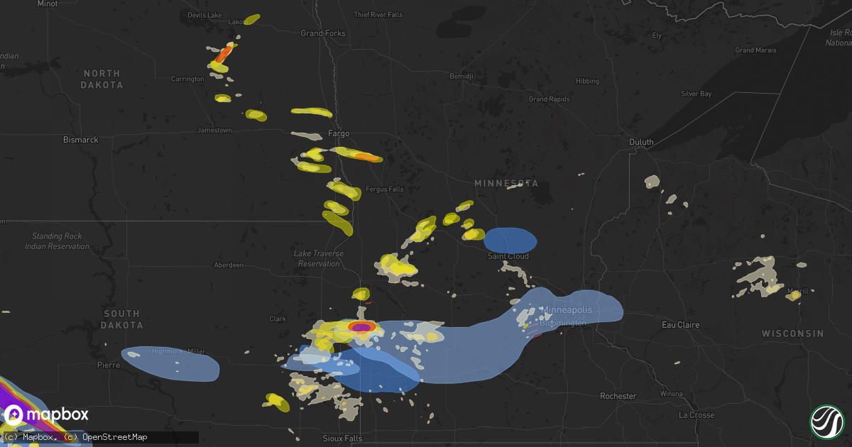
Hail Map on June 28, 2025
Get this storm
June 28 map
$229
one time, instant access
Download today. No call, no setup
Keep the $229
Bought the map and want the full workflow? Apply the entire $229 to a subscription within 7 days. None of it is wasted.
Every map, not just this one
This buys you this map. Subscription and you get every map we run, in the markets you choose from a few cities to whole states to nationwide. Plus real-time alerts the moment a storm fires.
Contact data
Name, contact info, occupancy, even credit band for addresses in the footprint. You go from where it hit to who to call.
Become the source they trust
Unlimited branding weather history reports on demand. You already have the documented answer ready for the property owner, and you are the one who showed up with it.
Property data and RoofTrace estimates
Pull up any address you have got, its value and the exact code rules for that jurisdiction, straight from One Click Code. Then RoofTrace estimates the squares, pitch, and roof value, priced the way you price.
States Impacted by Hail Map on June 28, 2025
Storm reports
Colorado
| Date | Description |
|---|---|
| 06/28/20256:58 PM CDT | A local report indicates 66 MPH wind near 5 ESE Holyoke |
| 06/28/20256:55 PM CDT | A local report indicates 73 MPH wind near 6 SE Holyoke |
| 06/28/20256:52 PM CDT | Mesonet station co048 us 385 holyoke. |
Alabama
| Date | Description |
|---|---|
| 06/28/20256:20 PM CDT | A tree was knocked down blocking both lanes of the roadway at 2310 cr 92. Time estimated by radar. |
| 06/28/20251:25 PM CDT | Corrects previous tstm wnd dmg report from 4 n fort payne. Tree down... Blocking the road at 1985 cr 85. Time estimated based on radar. |
| 06/28/20251:25 PM CDT | Tree down... Blocking the road. Time estimated based on radar. |
North Dakota
| Date | Description |
|---|---|
| 06/28/20256:47 PM CDT | Report from mping. |
| 06/28/20255:57 PM CDT | Report from mping. |
| 06/28/20255:40 PM CDT | Report relayed via social media. Quarter size hail and zero visibility in thunderstorm between mile marker 85 and fargo on interstate 29. Time and location estimated by |
| 06/28/20255:22 PM CDT | Corrects previous hail report from 15 n valley city. Was also reports of a few tree branches down. |
| 06/28/20255:20 PM CDT | Was also reports of a few tree branches down. |
| 06/28/20255:06 PM CDT | Picture shared via social media. Time estimated based on radar. |
| 06/28/20255:06 PM CDT | Corrects previous hail report from 1 n arthur. Picture shared via social media. Time estimated based on radar. |
| 06/28/20254:50 PM CDT | A local report indicates 1.00 inch wind near Erie |
| 06/28/20254:15 PM CDT | Largest hail was a quarter. More hail fell west of this location... Size unknown. |
| 06/28/20253:30 PM CDT | Photo received via social media. Largest hail stone estimated to be almost to golf ball sized... Most of which were irregular and jagged shaped. |
| 06/28/20251:43 PM CDT | Multiple reports of two landspout tornadoes ongoing at time of report. |
| 06/27/20258:30 PM CDT | Public sent in photo of hail beside a quarter. Time estimated from radar. |
| 06/27/20258:24 PM CDT | Report via icechip research team. |
| 06/27/20258:24 PM CDT | Report from mping: half dollar |
Pennsylvania
| Date | Description |
|---|---|
| 06/28/20256:20 PM CDT | A local report indicates 1.25 inch wind near 1 NW Mountville |
| 06/28/20255:19 PM CDT | Report of a tree d |
| 06/28/20255:19 PM CDT | Report of a tree down along pa 3016 near the intersection with starr road. Time estimated from radar. |
| 06/28/20255:10 PM CDT | Social media video of a tree falling in a back yard along connellsville road. |
| 06/28/20254:47 PM CDT | Multiple reports of trees and wires down along route 51 near rostraver rd. Time estimated from radar. |
| 06/28/20254:39 PM CDT | Tree down on bouquet road near frye road. |
| 06/28/20252:55 PM CDT | Trees/wires down in muncy twp. |
| 06/28/20252:55 PM CDT | Trees/wires down in muncy twp. |
| 06/28/20252:30 PM CDT | Multiple trees and wires down in loganton. |
| 06/28/20252:11 PM CDT | Corrects previous tstm wnd dmg report from 1 e shippingport. Report of a tree down along pa 3016 near the intersection with starr road. Time estimated from radar. |
| 06/28/202512:52 PM CDT | Churchill rd down power lines... Temporary road closure. |
| 06/28/202512:40 PM CDT | Tree down blocking larch road. Time estimated via radar. |
| 06/28/202512:22 PM CDT | Tree down on lost hill road. |
| 06/28/202512:20 PM CDT | Koa campground waltz mill rd tree down on a occupied camper... 3 individuals trapped negative injuries. |
| 06/28/202512:19 PM CDT | Tree down near the bells mill bridge. |
| 06/28/202511:55 AM CDT | Wires down on creek valley road. |
| 06/28/202511:54 AM CDT | Trees down in spring creek twp. |
| 06/28/202511:40 AM CDT | Tree down at intersection of route 899 and blue ridge road. Time estimated via radar. |
| 06/28/202511:37 AM CDT | Report of a tree and wires down along lincoln avenue. Time estimated from radar. |
| 06/28/202511:31 AM CDT | Tree down on miola road. |
| 06/28/202511:26 AM CDT | Tree down on route 36. |
| 06/28/202511:25 AM CDT | Wires down on guitonville road. |
| 06/28/202511:22 AM CDT | Tree down and wires down on lickingville road. |
| 06/28/202511:17 AM CDT | Tree down on marble strobleton road near old fryburg road. |
| 06/28/202511:15 AM CDT | Tree down on sunny road with wires. |
| 06/28/202511:15 AM CDT | Wires down on amsler road. |
| 06/28/202511:14 AM CDT | Tree down near route 322 and route 338. |
| 06/28/202511:14 AM CDT | Report of a tree and wires down blocking scott rd in somerset township. Time estimated from radar. |
| 06/28/202511:01 AM CDT | Flockerzi rd has a number of trees down. |
| 06/28/202510:56 AM CDT | Trees down in cranberry township . |
| 06/28/202510:56 AM CDT | Several trees and branches down with minor damage to an above ground pool. Time estimated via radar. |
| 06/28/202510:48 AM CDT | A number of trees down in western half of the county. |
| 06/28/202510:37 AM CDT | Trees down in western part of the county. |
| 06/28/202510:16 AM CDT | Power lines down on bentley ave. |
| 06/28/202510:15 AM CDT | Wires down in greenville... Pa. ( |
| 06/28/202510:15 AM CDT | Wires down in greenville... Pa. |
| 06/28/202510:12 AM CDT | Power lines down on crestview drive near rutledge road. |
| 06/28/202510:12 AM CDT | Tree and wires down on walnut street. |
| 06/27/20257:35 PM CDT | Tree down blocking bean hill road in lancaster township. |
New York
| Date | Description |
|---|---|
| 06/28/20251:25 PM CDT | Tree and wires down on prince brook road. |
| 06/28/202512:51 PM CDT | Tree down on county road 22 near canfield road. Time estimated from radar. |
Maryland
| Date | Description |
|---|---|
| 06/28/20256:00 PM CDT | Trees down on devilbliss bridge road. |
| 06/28/20255:10 PM CDT | Large tree branches down. |
| 06/28/20255:08 PM CDT | Tree down on us-40 alternate east. |
| 06/28/20254:59 PM CDT | A few trees were down around sharpsburg |
| 06/28/20254:37 PM CDT | A few trees were down around funkstown. |
| 06/28/20254:28 PM CDT | A few trees were down around halfway. |
West Virginia
| Date | Description |
|---|---|
| 06/28/20256:41 PM CDT | Trees down on winebrenner road near quincy lane. |
| 06/28/20255:34 PM CDT | Numerous trees down along bloomery pike around slanesville. |
| 06/27/20257:30 PM CDT | Tree down in a curve in the road on rocket boys drive near war. |
| 06/27/20257:25 PM CDT | Tree and wires down across the road. Time estimated via radar. |
Virginia
| Date | Description |
|---|---|
| 06/28/20256:58 PM CDT | A 73 mph gust was measured at the roanoke-blacksburg regional airport. |
| 06/28/20256:46 PM CDT | Power lines down in the 4000 block of kentucky avenue. Time estimated from radar. |
| 06/28/20256:45 PM CDT | Tree down on dickenson highway in clinchco. |
| 06/28/20256:18 PM CDT | A powerpoll was snapped along green spring road. |
| 06/28/20255:59 PM CDT | Tree downed onto power lines in the 4900 block of lee highway. Time estimated from radar. |
| 06/28/20255:35 PM CDT | One tree down in barren springs. |
| 06/28/20255:15 PM CDT | Tree down in south of the mountain rd near clintwood. |
| 06/28/20254:18 PM CDT | Tree down on 215 spring branch road. |
| 06/28/20254:09 PM CDT | Tree reported down on the 100 block of jonesboro road. |
| 06/28/20254:03 PM CDT | Numerous trees down north of madison on hampton village road... Hebron church road... And ruth road. |
| 06/28/20253:06 PM CDT | Trees down on power lines on shenandoah avenue in elkton. |
| 06/28/20252:38 PM CDT | Two trees reported down on weyers cave road between the 1000 block and the 1600 block. |
| 06/28/20251:02 PM CDT | Thunderstorm winds blew down one tree along the 600 block of dillons fork road. |
| 06/27/20258:28 PM CDT | A powerpoll was snapped along green spring road. |
| 06/27/20257:35 PM CDT | A few trees were down along wardensville grade and mcdonald road. |
| 06/27/20257:04 PM CDT | Thunderstorm winds blew down a large tree limb that fell on to a wire along the 900 block of grove lane. |
Minnesota
| Date | Description |
|---|---|
| 06/28/20255:14 PM CDT | Call out to gas station in lancaster resulted in report of lots of hail estimated to be around 1 inch. Time estimated on radar. |
| 06/28/20255:05 PM CDT | Picture with tape measure shared on social media. Time estimated by radar. |
| 06/28/20251:28 AM CDT | A local report indicates 61 MPH wind near 1 S Woodbury |
| 06/28/202512:45 AM CDT | Tree snapped near base and damaged fence. Time estimated from radar. |
| 06/28/202512:41 AM CDT | A local report indicates 1.25 inch wind near 1 NNE Norwood Young Ame |
| 06/28/202512:21 AM CDT | Tds confirmed via radar. |
| 06/28/202512:16 AM CDT | Tds confirmed on radar. |
| 06/28/202512:15 AM CDT | Trained spotter confirmed tornado on ground near hydes lake. |
| 06/28/202512:15 AM CDT | Tds confirmed on radar. |
| 06/28/202512:15 AM CDT | Tds confirmed via radar. |
| 06/27/202511:25 PM CDT | 3 inch diameter tree branches down. |
| 06/27/202511:25 PM CDT | Report via x of trees down in the city of st. Michael. Time estimated via radar. |
| 06/27/202511:20 PM CDT | Large tree branch snapped... About 6 inches in diameter. Time estimated from radar. |
| 06/27/202511:15 PM CDT | Asos station krwf redwood falls ap. |
| 06/27/202510:51 PM CDT | Strong winds broken down 2 inch diameter tree branches. |
| 06/27/202510:10 PM CDT | Personal weather station. |
| 06/27/202510:02 PM CDT | Storm chaser reported numerous trees down in renville. |
| 06/27/202510:00 PM CDT | Mesonet station mn064 t.h.10 - rice - mp 162 |
| 06/27/202510:00 PM CDT | Mesonet station mn064 t.h.10 - rice - mp 162. |
| 06/27/20259:55 PM CDT | 3-inch tree limbs down. Report via mping. Time estimated via radar. |
| 06/27/20259:50 PM CDT | Mesonet station mn033 t.h.23 - hanley falls - mp 94. |
| 06/27/20259:34 PM CDT | A local report indicates 74 MPH wind near Canby |
| 06/27/20258:36 PM CDT | Video of large tornado on the ground in field. |
| 06/27/20258:35 PM CDT | Sherriff dispatch reported tree damage 1 mile s of murdock. Damage possibly caused by tornado. |
| 06/27/20258:35 PM CDT | Sherriff dispatch reported tree damage 1 mile s o |
| 06/27/20258:23 PM CDT | Corrects previous hail report from 1 s barnesville. 25-40mm stones via icechip research team. |
| 06/27/20258:22 PM CDT | Report from mping: ping pong ball |
| 06/27/20258:20 PM CDT | Report from mping: half dollar |
| 06/27/20258:16 PM CDT | Report from mping: quarter |
| 06/27/20258:12 PM CDT | Report from mping. |
| 06/27/20258:08 PM CDT | A local report indicates 1.00 inch wind near 1 SW Alexandria |
| 06/27/20258:08 PM CDT | 20-30mm hail via icechip research team. |
| 06/27/20257:50 PM CDT | Tornado spotted on the ground 4.5 miles w of danvers. |
| 06/27/20257:24 PM CDT | Trained spotter confirmed tornado n of mn hwy 40 west of madison. |
| 06/27/20257:12 PM CDT | Downed tree. Time estimated from radar. |
Wyoming
| Date | Description |
|---|---|
| 06/28/20256:40 AM CDT | Photo shows hail from around half dollar to ping pong ball sized. Fell from 530 am to 540 am. |
| 06/28/20256:31 AM CDT | A local report indicates 1.25 inch wind near Newcastle |
| 06/28/20256:28 AM CDT | A local report indicates 1.00 inch wind near Newcastle |
| 06/27/202511:19 PM CDT | A local report indicates 90 MPH wind near 17 NNW New Haven |
| 06/27/202511:15 PM CDT | A local report indicates 58 MPH wind near 17 NNW New Haven |
| 06/27/202511:14 PM CDT | A local report indicates 65 MPH wind near 7 NW Rockypoint |
| 06/27/20259:08 PM CDT | Wy1. Coleman wydot. |
| 06/27/20258:48 PM CDT | Asos station krwl 1 ene rawlins. |
| 06/27/20258:39 PM CDT | Asos station krwl 1 ene rawlins. |
Montana
| Date | Description |
|---|---|
| 06/27/202510:45 PM CDT | A local report indicates 60 MPH wind near 12 E Moorhead |
| 06/27/202510:24 PM CDT | Mesonet station bshm8 bradshaw creek. |
| 06/27/20259:45 PM CDT | Parts of roof falling off. |
| 06/27/20259:06 PM CDT | A local report indicates 1.25 inch wind near 2 S Kirby |
Tennessee
| Date | Description |
|---|---|
| 06/28/20255:12 PM CDT | Tree and storage building damage on hima rd. |
South Dakota
| Date | Description |
|---|---|
| 06/28/20256:59 PM CDT | Relayed from multiple spotters. |
| 06/28/20256:47 PM CDT | A local report indicates 1.00 inch wind near 14 E Ellsworth AFB |
| 06/28/20256:45 PM CDT | A local report indicates 59 MPH wind near 3 NW Wasta |
| 06/28/20256:20 PM CDT | A local report indicates 1.25 inch wind near 7 NNE Ellsworth AFB |
| 06/28/20256:20 PM CDT | A local report indicates 65 MPH wind near 2 E Elm Springs |
| 06/28/20256:05 PM CDT | A local report indicates 66 MPH wind near 11 SSE Hereford |
| 06/28/20256:00 PM CDT | A local report indicates 60 MPH wind near 14 E Ellsworth AFB |
| 06/28/20255:55 PM CDT | A local report indicates 1.50 inch wind near 7 NNE Ellsworth AFB |
| 06/28/20255:55 PM CDT | A local report indicates 1.50 inch wind near 4 N Dwtn Rapid City |
| 06/28/20255:42 PM CDT | A local report indicates 80 MPH wind near 1 N Hereford |
| 06/28/20255:42 PM CDT | A local report indicates 2.50 inch wind near 1 N Hereford |
| 06/28/20255:35 PM CDT | A local report indicates 1.75 inch wind near 6 NNW Hereford |
| 06/28/20255:00 PM CDT | A local report indicates 80 MPH wind near Vale |
| 06/28/20255:00 PM CDT | A local report indicates 2.50 inch wind near Vale |
| 06/28/20254:50 PM CDT | A local report indicates 85 MPH wind near 1 NNW Nisland |
| 06/28/20254:45 PM CDT | A local report indicates 74 MPH wind near 1 NNW Nisland |
| 06/28/20254:42 PM CDT | A local report indicates 80 MPH wind near 2 W Nisland |
| 06/28/20254:42 PM CDT | A local report indicates 1.75 inch wind near 2 W Nisland |
| 06/28/20254:35 PM CDT | Winds to at least 60 mph. Windows broken in the house and camper. |
| 06/28/20254:15 PM CDT | Winds also to 60 mph. |
| 06/28/20254:15 PM CDT | A local report indicates 1.00 inch wind near 14 N Belle Fourche |
| 06/28/20254:01 PM CDT | A local report indicates 59 MPH wind near 13 NW Belle Fourche |
| 06/28/20257:45 AM CDT | Awos station kbkx brookings municipal airport. |
| 06/28/20257:41 AM CDT | Mesonet station vgas2 volga |
| 06/28/20257:40 AM CDT | Measured by personal weather station. |
| 06/28/20257:16 AM CDT | Tree damage and around 1 mile of power poles downed by thunderstorm winds. |
| 06/28/20256:06 AM CDT | Personal weather station peak gust. |
| 06/28/20256:04 AM CDT | Mesonet station 289 lees corner |
| 06/28/20256:04 AM CDT | Mesonet station 289 lee |
| 06/28/20255:53 AM CDT | Mesonet station 201 gann valley |
| 06/28/20255:49 AM CDT | Mesonet station 312 ree heights |
| 06/28/20255:48 AM CDT | Mesonet station 183 macs corner |
| 06/28/20255:48 AM CDT | Mesonet station 183 ma |
| 06/28/20255:37 AM CDT | Mesonet station 183 macs corner |
| 06/28/20255:30 AM CDT | Mesonet station hihs2 highmore |
| 06/28/20255:14 AM CDT | Davis weather station in holabird. |
| 06/28/20255:09 AM CDT | Mesonet station 19 harrold |
| 06/28/20251:16 AM CDT | A local report indicates 58 MPH wind near 15 SSE Mission |
| 06/28/20251:10 AM CDT | A local report indicates 65 MPH wind near 1 S White River |
| 06/28/202512:50 AM CDT | A local report indicates 71 MPH wind near 11 SW Parmelee |
| 06/28/202512:45 AM CDT | Time estimated from radar |
| 06/28/202512:45 AM CDT | A local report indicates 73 MPH wind near 3 NNE Harrington |
| 06/28/202512:40 AM CDT | A local report indicates 68 MPH wind near 11 SW Parmelee |
| 06/28/202512:35 AM CDT | A local report indicates 61 MPH wind near 13 NW Belle Fourche |
| 06/28/202512:32 AM CDT | Mesonet station 224 sd rwis ward. |
| 06/28/202512:10 AM CDT | A local report indicates 58 MPH wind near 4 ENE Martin |
| 06/28/202512:05 AM CDT | A local report indicates 60 MPH wind near 1 ESE Martin |
| 06/28/202512:03 AM CDT | Awos station kbkx brookings municipal airport. |
| 06/27/202511:48 PM CDT | Mesonet station vgas2 volga |
| 06/27/202511:41 PM CDT | A local report indicates 67 MPH wind near 5 NE Porcupine |
| 06/27/202511:06 PM CDT | Hail was briefly nickel to quarter size. |
| 06/27/202510:54 PM CDT | Trained spotter had quarter plus sized hail 1 mile east of lake poinsett. |
| 06/27/202510:18 PM CDT | State radio report of a different tornado 1 mile north of toronto. |
| 06/27/202510:16 PM CDT | State radio report of tornado 1 mile east of toronto. |
| 06/27/20259:50 PM CDT | A local report indicates 1.00 inch wind near 2 S Thomas |
| 06/27/20259:40 PM CDT | A local report indicates 1.00 inch wind near 4 W Castlewood |
| 06/27/20259:20 PM CDT | A local report indicates 58 MPH wind near 15 SSE Mission |
| 06/27/20258:58 PM CDT | Report from mping: hen egg |
| 06/27/20258:47 PM CDT | Tornado in gary took out a house. |
| 06/27/20258:40 PM CDT | Estimated 60 to 70 mph |
| 06/27/20258:30 PM CDT | Tornado reported around the lake cochrane rec area. |
| 06/27/20258:24 PM CDT | A local report indicates 60 MPH wind near 5 SE Norris |
| 06/27/20258:13 PM CDT | Spotter called with a tornado on the ground. |
| 06/27/20257:50 PM CDT | A local report indicates 1.00 inch wind near 1 NW Kadoka |
| 06/27/20257:45 PM CDT | A local report indicates 73 MPH wind near 4 E Cactus Flat |
| 06/27/20257:35 PM CDT | A local report indicates 85 MPH wind near 4 E Cactus Flat |
| 06/27/20257:30 PM CDT | A local report indicates 78 MPH wind near 4 E Cactus Flat |
| 06/27/20257:25 PM CDT | A local report indicates 67 MPH wind near 4 E Cactus Flat |
| 06/27/20257:25 PM CDT | Took out jackson co. Deputy sheriff's windshield on i-90 |
| 06/27/20257:21 PM CDT | A local report indicates 68 MPH wind near 6 W Cottonwood |
| 06/27/20257:11 PM CDT | A local report indicates 60 MPH wind near 6 W Cottonwood |
| 06/27/20257:07 PM CDT | Trees blown down and abandoned structure was damaged/hit. |
Mississippi
| Date | Description |
|---|---|
| 06/28/20255:50 PM CDT | Trees down across highway 51 at belmont road. Time is radar estimated. |
| 06/28/20255:20 PM CDT | Several trees down in walls. Time is radar estimated. |
Indiana
| Date | Description |
|---|---|
| 06/28/20254:50 PM CDT | A few trees down in haysville. |
Nebraska
| Date | Description |
|---|---|
| 06/28/20256:13 PM CDT | Mesonet station agtn1 3 ene agate ne - agate fossil beds raws - agt. |
| 06/28/20256:13 PM CDT | Mesonet st |
| 06/28/20255:17 PM CDT | Asos station ksny sidney airport. |
| 06/28/20256:00 AM CDT | Personal weather station measured gust of 58 mph. |
| 06/28/20256:00 AM CDT | Personal weather station measured |
| 06/28/20256:00 AM CDT | Pers |
| 06/28/20255:57 AM CDT | A local report indicates 58 MPH wind near 4 W Offutt Afb |
| 06/28/20255:55 AM CDT | A local report indicates 68 MPH wind near 1 WSW Offutt Afb |
| 06/28/20255:38 AM CDT | Koma asos measured gust of 61 mph. |
| 06/28/20251:29 AM CDT | Asos station kvtn valentine airport. |
| 06/27/202510:16 PM CDT | A local report indicates 63 MPH wind near Valentine |
| 06/27/20259:43 PM CDT | A local report indicates 65 MPH wind near 5 SE Grant |
| 06/27/20259:19 PM CDT | Wind gust from decaying thunderstorms. |
| 06/27/20259:19 PM CDT | Wind gust from decayi |
| 06/27/20259:15 PM CDT | A local report indicates 65 MPH wind near 5 SE Grant |
| 06/27/20257:26 PM CDT | A local report indicates 1.00 inch wind near 4 E Angora |
| 06/27/20257:24 PM CDT | Mainly dime to nickel size hail with a few quarters. |
| 06/27/20257:24 PM CDT | A local report indicates 1.00 inch wind near 3 NE Big Springs |
Georgia
| Date | Description |
|---|---|
| 06/28/20255:55 PM CDT | Social media report showing a tree down at lavista rd between houston mill rd nw and n druid hills rd. |
| 06/27/20258:23 PM CDT | Em reports tree down at sequoyah circle at hickory rd. (ffc |
| 06/27/20258:23 PM CDT | Em reports tree down at sequoyah circle at hickory rd. |
| 06/27/20258:08 PM CDT | Em reports tree down at whitney court near surveyor walk. |
| 06/27/20257:55 PM CDT | Tree down in road along 4000 block of wyndam hill dr ne in suwanee. |
| 06/27/20257:50 PM CDT | Numerous trees down along sugar crest drive... Including on at least 2 homes. |
| 06/27/20257:50 PM CDT | Tree down on home along hillington way... Tree down in road at intersection of hillcrest drive and gable ridge way. |
| 06/27/20257:50 PM CDT | Tree on porch of home and multiple trees down in road along hesse lane. |
| 06/27/20257:48 PM CDT | Public called in with report of tree and fence down and trampoline lifted at two bridge ct near two bridge dr. |
North Carolina
| Date | Description |
|---|---|
| 06/28/20255:09 PM CDT | Trees down on buffalo shoals rd. Time estimated. |
| 06/28/20255:00 PM CDT | Utility company reports trees down causing power outages near troutman. |
| 06/28/20255:00 PM CDT | Utility company reports trees down causing power outages near troutman. |
| 06/28/20254:00 PM CDT | 911 communications reported powerlines down leading to power outage near hickory lincolnton hwy. |
| 06/28/20253:45 PM CDT | 911 communications reports powerlines down near downtown hickory. |
| 06/28/20253:24 PM CDT | 911 communications center reports numerous trees and power lines down across the mocksville area. |
| 06/28/20253:00 PM CDT | Kittrell fire dept had to remove a tree from the road at 757 kittrell college rd. |
| 06/28/20252:28 PM CDT | Tree down. |
| 06/28/20252:26 PM CDT | Tree down. |
| 06/28/20252:25 PM CDT | Utility company reports power outage due to fallen trees on equipment. |
| 06/28/20252:19 PM CDT | Downed tree in roadway. |
| 06/28/20252:04 PM CDT | Trees fallen on power equipment. |
| 06/28/20252:04 PM CDT | Trees fallen on power equipment. |
| 06/28/20251:57 PM CDT | Caller reported a tree fell and struck their apartment. |
| 06/28/20251:51 PM CDT | Trees down on power equipment. |
| 06/28/20251:51 PM CDT | Trees down on power equipment. |
| 06/28/20251:43 PM CDT | Outage was caused by fallen trees on equipment. |
| 06/28/20251:43 PM CDT | Outage was caused by fallen trees on equipment. |
Arkansas
| Date | Description |
|---|---|
| 06/28/20254:25 PM CDT | Damage occurred to a home garage door and a large exterior porch structure. Nearby power poles were knocked over as well. |
| 06/28/20252:20 PM CDT | Roof damage to a metal storage building. |
South Carolina
| Date | Description |
|---|---|
| 06/28/20256:55 PM CDT | 911 communications reports tree blocking roadway on the intersection of neal shoals road and davis jeter road. |
| 06/28/20252:35 PM CDT | Glassy mountain vfd reported a tree down on a powerline near the intersection of sc 11 and sc 101. Time estimated from radar. |
| 06/27/20259:46 PM CDT | Social media report of trees down between ware shoals and lake greenwood... Time and location estimated by radar. |
| 06/27/20259:31 PM CDT | Social media report of a tree down on a chicken coop... Time and location estimated by radar. |
| 06/27/20257:00 PM CDT | 911 communications reports tree blocking roadway in monarch mill. |
Iowa
| Date | Description |
|---|---|
| 06/28/20255:41 AM CDT | Picture relayed by media of large cottonwood tree and pear tree blown down. Time based on radar... Location at lake manawa. |
| 06/28/20254:55 AM CDT | Numerous large tree limbs down... Some in excess of 12 inches diameter. Power out due to tree limbs falling on power lines. |
| 06/28/20254:45 AM CDT | Photos on social media of large tree limbs down at holstein park. |
| 06/28/20254:22 AM CDT | Personal weather station peak wind gust. |
| 06/28/20254:09 AM CDT | Photos of numerous large tree limbs down. |
| 06/28/20254:09 AM CDT | Numerous 6 inch diameter tree limbs down as well as several trees down around town. Some hail... Unknown size. |
| 06/28/20254:04 AM CDT | Numerous large tree limbs down. Large empty water tanks blown into cemetery. |
| 06/28/20254:00 AM CDT | Personal weather station peak wind gust. |
| 06/28/20254:00 AM CDT | Large tree snapped in half in the city of remsen. |
| 06/28/20253:57 AM CDT | Personal weather station peak wind gust. |
| 06/28/20253:55 AM CDT | Tree damage throughout town. Damage to local campground. Power outages across portions of the city. |
| 06/28/20253:52 AM CDT | Awos station klrj le mars airport. |
| 06/28/20253:50 AM CDT | Personal weather station peak wind gust. |
| 06/28/20253:48 AM CDT | Awos station ksxk 1 ne maurice. |
Wisconsin
| Date | Description |
|---|---|
| 06/28/202512:46 AM CDT | Report of a couple of powerlines down. |
Florida
| Date | Description |
|---|---|
| 06/28/20253:20 PM CDT | Broadcast media relayed report of a tree down in the osprey point neighborhood between san pablo road and hodges blvd. |
| 06/28/20253:15 PM CDT | Severe thunderstorm damage occurred to utility equipment in neptune beach between first and 2nd street... Just north of 3rd street. The time of damage was based on rada |
| 06/28/20253:10 PM CDT | Jea reported equipment damage from a severe thunderstorm just south of atlantic blvd between sunnyside ave and riverview drive. The time of damage was based on radar. |
Ohio
| Date | Description |
|---|---|
| 06/28/20256:15 PM CDT | Limbs blown onto old state route 32. |
| 06/28/20256:10 PM CDT | Treeline along old state route 32 and big run had trees blown down. |
| 06/28/20255:57 PM CDT | Trees down. Time estimated from radar. |
| 06/28/20255:47 PM CDT | A couple trees down on lines on state route 93 near portie-flamingo road. |
| 06/28/20255:42 PM CDT | Corrects time of previous hail report from 2 nne landen. Golf ball size hail reported in deerfield twp. |
| 06/28/20255:36 PM CDT | Multiple trees down in the sugar grove area. Time estimated from radar. |
| 06/28/20255:06 PM CDT | A local report indicates 62 MPH wind near 2 NNE Fairfield |
| 06/28/20255:06 PM CDT | A local report indicates 62 MPH wind near 2 NNE Fairfield |
| 06/28/20254:18 PM CDT | Tree down near cedar street and east main street. Time estimated from radar. |
| 06/28/20252:28 PM CDT | A few trees were blown down... Scattered about the county. |
| 06/27/20257:06 PM CDT | Golf ball size hail reported in deerfield twp. |
Kansas
| Date | Description |
|---|---|
| 06/27/202510:38 PM CDT | Prairie ag weather station. |
| 06/27/20259:58 PM CDT | A local report indicates 68 MPH wind near 1 SW Garden City |
| 06/27/20259:24 PM CDT | Emergency manager reports a microburst with broken poles and downed tree limbs around 6 inches in diameter. |
| 06/27/20259:15 PM CDT | Mesonet station fw1490 leoti measured 71 mph wind gust. |
| 06/27/20258:03 PM CDT | Spotter estimated peak winds of 60 mph. |
Cities Impacted by Hail Map on June 28, 2025
- Erwin, SD
- De Smet, SD
- Hitchcock, SD
- Arlington, SD
- Lake Preston, SD
- Huron, SD
- Lake Norden, SD
- Badger, SD
- Worthington, MN
- Volga, SD
- Bruce, SD
- Brookings, SD
- Aurora, SD
- White, SD
- Elkton, SD
- Hartland, MN
- Albert Lea, MN
- Alden, MN
- Walnut Grove, MN
- Kevil, KY
- Metropolis, IL
- West Paducah, KY
- Paducah, KY
- Buchanan, TN
- Murray, KY
- Saint Louisville, OH
- Newark, OH
- Lebanon, TN
- Mount Solon, VA
- Lithia, FL
- Durham, NC
- Pittsboro, NC
- Stanton, TN
- Somerville, TN
- Corydon, IN
- Kensal, ND
- Chambersburg, PA
- Bradenton, FL
- Salisbury, NC
- Asheville, NC
- Auburndale, FL
- Waterville, PA
- Glenfield, ND
- Jersey Shore, PA
- Granville, OH
- Lexington, NC
- Winter Haven, FL
- Chapel Hill, TN
- Eagleville, TN
- Madison, FL
- Cogan Station, PA
- Grace City, ND
- Lock Haven, PA
- Brownsville, TN
- Linden, PA
- Williamsport, PA
- Lake Alfred, FL
- Mchenry, ND
- Berryville, VA
- Campbellsville, KY
- Myakka City, FL
- Jacksonville, FL
- Montoursville, PA
- Hulett, WY
- Henderson, NC
- Kittrell, NC
- Tolna, ND
- New Rockford, ND
- Pekin, ND
- Mocksville, NC
- Jacksonville Beach, FL
- Alzada, MT
- Belle Fourche, SD
- Vero Beach, FL
- Saint Cloud, FL
- Fort Pierce, FL
- Ripley, TN
- Summertown, TN
- Kimbolton, OH
- Kenansville, FL
- Okeechobee, FL
- Culleoka, TN
- Lakota, ND
- Michigan, ND
- Buffalo, SD
- Sutton, ND
- Tatum, NM
- Courtenay, ND
- Cleveland, GA
- Sautee Nacoochee, GA
- Clarkesville, GA
- Binford, ND
- Petersburg, ND
- Cambridge, OH
- Avon Park, FL
- Corinth, MS
- Nisland, SD
- Newell, SD
- Newcomerstown, OH
- Demorest, GA
- Martinsburg, WV
- Falling Waters, WV
- Williamsport, MD
- Page, ND
- Erie, ND
- Pembina, ND
- Saint Vincent, MN
- Hallock, MN
- Lancaster, MN
- Vale, SD
- Whitewood, SD
- Cooperstown, ND
- Wimbledon, ND
- Hannaford, ND
- Warwick, ND
- Hagerstown, MD
- Boonsboro, MD
- Union Springs, AL
- Shepherdstown, WV
- Fairfield, OH
- Hamilton, OH
- West Chester, OH
- Middletown, OH
- Venus, FL
- Rogers, ND
- Sebring, FL
- Punta Gorda, FL
- North Fort Myers, FL
- Arcadia, FL
- Lorida, FL
- Hunter, ND
- Arthur, ND
- Elizabeth, PA
- Monongahela, PA
- Clairton, PA
- Millersport, OH
- Gardner, ND
- Sanborn, ND
- Valley City, ND
- Sturgis, SD
- Union Center, SD
- Deer Lodge, TN
- Allardt, TN
- Manila, AR
- Webster, PA
- Belle Vernon, PA
- Lovington, NM
- Leachville, AR
- Troy, AL
- Mcdonald, NM
- Lake Placid, FL
- Labelle, FL
- Cincinnati, OH
- Moore Haven, FL
- New Underwood, SD
- Jamestown, TN
- Lake Bronson, MN
- Argusville, ND
- Enning, SD
- Box Elder, SD
- Sidney, NE
- Peetz, CO
- Crook, CO
- Lodgepole, NE
- Augusta, WV
- Romney, WV
- Sunbright, TN
- Robbins, TN
- Wasta, SD
- Howes, SD
- Piedmont, SD
- Blairsville, GA
- Healy, KS
- Felda, FL
- Immokalee, FL
- Caputa, SD
- Owanka, SD
- Manchester, OH
- Aberdeen, OH
- Castlewood, SD
- Galax, VA
- Fries, VA
- Morrow, OH
- Maineville, OH
- Junction City, OH
- New Straitsville, OH
- Rugby, TN
- Stoutsville, OH
- Circleville, OH
- Laurelville, OH
- Amanda, OH
- Tarlton, OH
- Lititz, PA
- Newmanstown, PA
- Monroe, OH
- South Lebanon, OH
- Mason, OH
- Blanchester, OH
- Pleasant Plain, OH
- Kings Mills, OH
- Badger, MN
- Greenbush, MN
- Leonard, ND
- Davenport, ND
- Kindred, ND
- Milbank, SD
- Big Stone City, SD
- Odessa, MN
- Bellingham, MN
- Marietta, MN
- Watertown, SD
- Goodwin, SD
- Clear Lake, SD
- Wall, SD
- Appleton, MN
- Hebron, OH
- Gunnison, MS
- Bloomery, WV
- Capon Bridge, WV
- Rapid City, SD
- Scenic, SD
- Hancock, MN
- Danvers, MN
- Lancaster, OH
- Hillsville, VA
- Austinville, VA
- Union, SC
- Horace, ND
- Willis, VA
- Decatur, AR
- Gravette, AR
- Buffalo, ND
- Hobbs, NM
- Labolt, SD
- Revillo, SD
- Wheatland, ND
- Mapleton, ND
- Quinn, SD
- Hope, IN
- Flat Rock, IN
- Walcott, ND
- Benson, MN
- Clontarf, MN
- Gary, SD
- Big Springs, NE
- Brule, NE
- Waynesville, OH
- Thornville, OH
- Pleasantville, OH
- Lebanon, OH
- Franklin, OH
- Clarksville, OH
- Bella Vista, AR
- Bentonville, AR
- Kadoka, SD
- Philip, SD
- Fairplay, MD
- Goshen, OH
- Loveland, OH
- Interior, SD
- Wanblee, SD
- Alliance, NE
- Ellsworth, NE
- Yuma, CO
- Haxtun, CO
- Holyoke, CO
- Wray, CO
- Amherst, CO
- Comstock, MN
- Moorhead, MN
- Holloway, MN
- Centerton, AR
- De Witt, AR
- Pryor, MT
- Lodge Grass, MT
- Bremen, OH
- Dacula, GA
- Buford, GA
- Madison, MN
- Sheridan Lake, CO
- Sabin, MN
- Rushville, OH
- Seminole, TX
- Barnesville, MN
- Inwood, WV
- Kearneysville, WV
- Hedgesville, WV
- Farwell, MN
- Morris, MN
- Fort Stockton, TX
- Wolverton, MN
- Rothsay, MN
- Pelican Rapids, MN
- Sheldon, ND
- Wyndmere, ND
- Mcleod, ND
- Alexandria, MN
- Garfield, MN
- Kensington, MN
- Carlos, MN
- Osakis, MN
- Long Prairie, MN
- Eagle Bend, MN
- Chokio, MN
- Alberta, MN
- Mooreton, ND
- Wahpeton, ND
- Colfax, ND
- Leoti, KS
- Cyrus, MN
- Winchester, OH
- Seaman, OH
- Lowry, MN
- Long Valley, SD
- Breckenridge, MN
- Campbell, MN
- Hankinson, ND
- Mantador, ND
- Nelson, MN
- Washington Boro, PA
- Conestoga, PA
- Peebles, OH
- Millersville, PA
- Stevens, PA
- Lebanon, PA
- Ephrata, PA
- Columbia, PA
- Mount Joy, PA
- Marietta, PA
- Lancaster, PA
- East Petersburg, PA
- Manheim, PA
- West Union, OH
- Angora, NE
- Bridgeport, NE
- Belvidere, SD
- White River, SD
- Norris, SD
- Saint Xavier, MT
- Garryowen, MT
- Fairmount, ND
- Strandburg, SD
- Canby, MN
- Julesburg, CO
- Salem, VA
- Points, WV
- Grey Eagle, MN
- Burtrum, MN
- Allen, SD
- Swanville, MN
- Marienthal, KS
- Barney, ND
- Kent, MN
- Logan, OH
- Sugar Grove, OH
- Pequea, PA
- Willow Street, PA
- Starbuck, MN
- Lidgerwood, ND
- Martin, SD
- Busby, MT
- Decker, MT
- Birney, MT
- Porcupine, SD
- Batesland, SD
- Clinton, SC
- Grantsville, WV
- Rosholt, SD
- New Effington, SD
- Sauk Centre, MN
- Melrose, MN
- Freeport, MN
- Correll, MN
- Laurens, SC
- Hazel, SD
- Sundance, WY
- Hill City, SD
- Hermosa, SD
- Recluse, WY
- Moorcroft, WY
- Weston, WY
- Lead, SD
- Gillette, WY
- Otter, MT
- Hayti, SD
- Boyd, MN
- Minneota, MN
- Porter, MN
- Taunton, MN
- Brandt, SD
- Estelline, SD
- Browerville, MN
- Brasstown, NC
- Greensburg, KY
- Clarissa, MN
- Deerfield, KS
- Holcomb, KS
- Garden City, KS
- Upsala, MN
- Johnson, KS
- Ware Shoals, SC
- Holdingford, MN
- Bowlus, MN
- Albany, MN
- Cushing, MN
- Astoria, SD
- Wheaton, MN
- Broadus, MT
- Glenwood, MN
- Villard, MN
- Charleston, MS
- Rosedale, MS
- Murdock, MN
- Avon, MN
- Royalton, MN
- Foley, MN
- Pierz, MN
- Saint Joseph, MN
- Rice, MN
- Saint Stephen, MN
- Sartell, MN
- Saint Cloud, MN
- Sauk Rapids, MN
- Foreston, MN
- Hillman, MN
- Oak Park, MN
- Toronto, SD
- Clarkfield, MN
- Granite Falls, MN
- Sacred Heart, MN
- Dawson, MN
- Hanley Falls, MN
- Wood Lake, MN
- Ivanhoe, MN
- Cottonwood, MN
- Hendricks, MN
- Sublette, KS
- Pierceville, KS
- Lakin, KS
- Hot Springs, SD
- Burton, WV
- Kyle, SD
- Bryant, SD
- Colome, SD
- Mount Zion, WV
- Springview, NE
- Winner, SD
- Valentine, NE
- Sparks, NE
- Buffalo Gap, SD
- Mission, SD
- Harrison, NE
- Minter City, MS
- Olive Hill, KY
- Dallas, SD
- Renville, MN
- Marshall, MN
- Echo, MN
- Ghent, MN
- Belview, MN
- Arco, MN
- Danube, MN
- Olivia, MN
- Lynd, MN
- Johnstown, NE
- Wood Lake, NE
- Copeland, KS
- Ingalls, KS
- Gregory, SD
- Burke, SD
- Ulysses, KS
- Jacksonburg, WV
- Smithfield, WV
- Montezuma, KS
- Cedar Bluff, VA
- Willow Lake, SD
- Kendall, KS
- Richfield, KS
- Willmar, MN
- Bandy, VA
- Mills, NE
- Pine Ridge, SD
- North Tazewell, VA
- Iroquois, SD
- Platte, SD
- Ainsworth, NE
- Long Pine, NE
- Plains, KS
- Devils Tower, WY
- Howard Lake, MN
- Brainerd, MN
- Oldham, SD
- Maple Lake, MN
- Annandale, MN
- Kimball, MN
- Monticello, MN
- Clearwater, MN
- South Haven, MN
- Clear Lake, MN
- Harrison, SD
- Corsica, SD
- Cold Spring, MN
- Buffalo, MN
- Hector, MN
- Bird Island, MN
- Brownton, MN
- Stewart, MN
- Buffalo Lake, MN
- Redwood Falls, MN
- Morton, MN
- Hutchinson, MN
- Vesta, MN
- Glencoe, MN
- Balaton, MN
- Seaforth, MN
- Russell, MN
- Milroy, MN
- Fairfax, MN
- Lucan, MN
- Tracy, MN
- Wabasso, MN
- Garvin, MN
- Franklin, MN
- Big Lake, MN
- Hemingford, NE
- Silver Lake, MN
- Winsted, MN
- Deerwood, MN
- Moscow, KS
- Cokato, MN
- Waverly, MN
- Ramona, SD
- Howard, SD
- Bassett, NE
- Saint Michael, MN
- Winfred, SD
- Young America, MN
- Cologne, MN
- Green Isle, MN
- Arlington, MN
- Norwood Young America, MN
- Morgan, MN
- Plato, MN
- New Auburn, MN
- Hamburg, MN
- Waconia, MN
- Winthrop, MN
- Lester Prairie, MN
- Chaska, MN
- Gaylord, MN
- Gibbon, MN
- Clements, MN
- Carver, MN
- New Germany, MN
- Maple Plain, MN
- Mound, MN
- Delano, MN
- Victoria, MN
- Watertown, MN
- Montrose, MN
- Excelsior, MN
- Saint Bonifacius, MN
- Mayer, MN
- Chanhassen, MN
- Hanover, MN
- Rockford, MN
- Hamel, MN
- Loretto, MN
- Wayzata, MN
- Long Lake, MN
- Rogers, MN
- Spring Park, MN
- Lusk, WY
- Herrick, SD
- Minneapolis, MN
- Osseo, MN
- Dayton, MN
- Eden Prairie, MN
- Minnetonka, MN
- Maple Grove, MN
- Alexandria, SD
- Alva, WY
- Belle Plaine, MN
- Lamberton, MN
- Hopkins, MN
- Henderson, MN
- Shakopee, MN
- Sleepy Eye, MN
- Sanborn, MN
- New Ulm, MN
- Springfield, MN
- Le Sueur, MN
- Wanda, MN
- Saint Peter, MN
- Lafayette, MN
- Comfrey, MN
- Courtland, MN
- Revere, MN
- Hanska, MN
- Nicollet, MN
- Lake Benton, MN
- Ruthton, MN
- Pipestone, MN
- Flandreau, SD
- Aladdin, WY
- Manderson, SD
- Tuthill, SD
- Wounded Knee, SD
- Sturgeon Lake, MN
- Saint Charles, SD
- Madison, SD
- Nunda, SD
- Merriman, NE
- Newport, NE
- Stuart, NE
- Bonesteel, SD
- Savage, MN
- Holland, MN
- Tyler, MN
- Woodstock, MN
- Rutland, SD
- Fedora, SD
- Jordan, MN
- Gordon, WI
- Solon Springs, WI
- Beulah, WY
- Saint Francis, SD
- Cody, NE
- Spearfish, SD
- Saint Onge, SD
- Artesian, SD
- Canova, SD
- Parmelee, SD
- Kilgore, NE
- Lake Wilson, MN
- Currie, MN
- Slayton, MN
- Springbrook, WI
- Carthage, SD
- Minong, WI
- Reva, SD
- Prairie City, SD
- Wentworth, SD
- Colman, SD
- Naper, NE
- Spencer, SD
- Crookston, NE
- Nenzel, NE
- Tripp, SD
- Avon, SD
- Bison, SD
- Wagner, SD
- Avoca, MN
- Satanta, KS
- Atkinson, NE
- Hayward, WI
- Prior Lake, MN
- Edgemont, SD
- Dante, SD
- Saint Paul, MN
- Lake Elmo, MN
- Stillwater, MN
- Afton, MN
- South Saint Paul, MN
- Hudson, WI
- Saint Paul Park, MN
- Houlton, WI
- Bayport, MN
- Hastings, MN
- Cottage Grove, MN
- Inver Grove Heights, MN
- Newport, MN
- Burnsville, MN
- River Falls, WI
- Lakeland, MN
- Mendota, MN
- Circle Pines, MN
- Hugo, MN
- Marine On Saint Croix, MN
- Willernie, MN
- Somerset, WI
- Roberts, WI
- New Richmond, WI
- Rosebud, SD
- Mud Butte, SD
- Fulda, MN
- Egan, SD
- Trent, SD
- Heron Lake, MN
- Westbrook, MN
- Lesterville, SD
- Niobrara, NE
- Center, NE
- Winter, WI
- Utica, SD
- Oral, SD
- Menno, SD
- Scotland, SD
- Springfield, SD
- Verdigre, NE
- Brewster, MN
- Delmont, SD
- Chambers, NE
- Lance Creek, WY
- Mission Hill, SD
- Volin, SD
- Bloomfield, NE
- Gilman, WI
- Fairburn, SD
- Ewing, NE
- Oelrichs, SD
- Crofton, NE
- Winnetoon, NE
- Yankton, SD
- Irene, SD
- Sheldon, WI
- Dell Rapids, SD
- Edgerton, MN
- Kennan, WI
- Catawba, WI
- Medford, WI
- Withee, WI
- Chadron, NE
- Fordyce, NE
- Saint Helena, NE
- Osage City, KS
- Gayville, SD
- Wausa, NE
- Amelia, NE
- Whitney, NE
- Westboro, WI
- Prentice, WI
- Decker, IN
- Vincennes, IN
- Baltic, SD
- Bartlett, NE
- Jasper, MN
- Hartington, NE
- Wynot, NE
- Phillips, WI
- Brantwood, WI
- Garretson, SD
- Beresford, SD
- Plainview, NE
- Neligh, NE
- Ogema, WI
- Dover, DE
- Lebo, KS
- Hammond, WI
- Baldwin, WI
- Inwood, IA
- Petersburg, NE
- Canton, SD
- Vermillion, SD
- Rib Lake, WI
- Camden Wyoming, DE
- Alcester, SD
- Hudson, SD
- Melvern, KS
- Fairview, SD
- Rock Valley, IA
- Merrill, WI
- Tripoli, WI
- Letcher, SD
- Plankinton, SD
- Lublin, WI
- Irma, WI
- Tomahawk, WI
- Stickney, SD
- Mount Vernon, SD
- Albion, NE
- Athens, WI
- Waverly, KS
- Hawarden, IA
- Pierce, NE
- Fort Meade, SD
- Lyndon, KS
- Garnett, KS
- Richmond, KS
- Norfolk, NE
- Brokaw, WI
- Wausau, WI
- Greeley, KS
- Marathon, WI
- Maurice, IA
- Orange City, IA
- Sioux Center, IA
- Stanton, NE
- Ireton, IA
- Independence, WI
- Le Mars, IA
- Atchison, KS
- Alton, IA
- Remsen, IA
- Oyens, IA
- Marcus, IA
- Granville, IA
- Oskaloosa, KS
- Ozawkie, KS
- Dodge, NE
- Howells, NE
- Nortonville, KS
- Pierre, SD
- Valley Falls, KS
- Deerbrook, WI
- Clarkson, NE
- Bryant, WI
- Macy, NE
- Parker, KS
- Lane, KS
- Wisner, NE
- Pilger, NE
- Leavenworth, KS
- Kingsley, IA
- Pierson, IA
- Tutwiler, MS
- Bridgewater, SD
- Columbus, NE
- Schuyler, NE
- West Point, NE
- Washta, IA
- Correctionville, IA
- Cleghorn, IA
- Quimby, IA
- Cherokee, IA
- Oakland, NE
- Blunt, SD
- Bellwood, NE
- McLouth, KS
- Lansing, KS
- Meriden, KS
- Easton, KS
- Winchester, KS
- Holstein, IA
- Scribner, NE
- Humboldt, NE
- Dawson, NE
- Kansas City, MO
- Platte City, MO
- Bruno, NE
- Linwood, NE
- David City, NE
- Blair, NE
- Fort Calhoun, NE
- Arlington, NE
- Mead, NE
- Yutan, NE
- Fremont, NE
- Bennington, NE
- Washington, NE
- Nickerson, NE
- Missouri Valley, IA
- Valley, NE
- Kennard, NE
- Crescent, IA
- Honey Creek, IA
- Omaha, NE
- Elkhorn, NE
- Council Bluffs, IA
- Neola, IA
- Waterloo, NE
- Underwood, IA
- Boys Town, NE
- Papillion, NE
- Gretna, NE
- Ashland, NE
- La Vista, NE
- McClelland, IA
- Carter Lake, IA
- Springfield, NE
- Ithaca, NE
- Verdon, NE
- Rock, MI
- Tonganoxie, KS
- Colon, NE
- Sturgeon Bay, WI
- Prague, NE
- Bark River, MI
- Escanaba, MI
- Bellevue, NE
- Hull, IA
- Sheldon, IA
- Boyden, IA
- Archer, IA
- Paullina, IA
- Primghar, IA
- Hartley, IA
- Sanborn, IA
- Sutherland, IA
- Hospers, IA
- Calumet, IA
- Meriden, IA
- Galva, IA
- Storm Lake, IA
- Peterson, IA
- Early, IA
- Larrabee, IA
- Aurelia, IA
- Schaller, IA
- Nemaha, IA
- Alta, IA
- Moville, IA
- Cushing, IA
- Akron, IA
- Lawton, IA
- Hinton, IA
- Chatsworth, IA
- Merrill, IA
- Brunsville, IA
- Westfield, IA
- Elk Point, SD
- Harrold, SD
- Highmore, SD
- Holabird, SD
- Onida, SD
- Stephan, SD
- Ree Heights, SD
- Miller, SD
- Independence, MO
- Dwight, NE
- Cornell, MI
- Valparaiso, NE
- Sabetha, KS
- Brussels, WI
- Salem, NE
- Falls City, NE
- Wahoo, NE
- Ceresco, NE
- Marinette, WI
- Abie, NE
- Weston, NE
- Forestville, WI
- Gann Valley, SD
- Wessington, SD
- Saint Lawrence, SD
- Wessington Springs, SD
- Danbury, IA
- Kiron, IA
- Battle Creek, IA
- Arthur, IA
- Anthon, IA
- Odebolt, IA
- Ida Grove, IA
- Pacific Junction, IA
- Offutt Afb, NE
- Plattsmouth, NE
- Murray, NE
- Louisville, NE
- Cedar Creek, NE
- Weeping Water, NE
- Nehawka, NE
- Glenwood, IA
- Newcastle, WY
- Talmage, NE
- Baileys Harbor, WI
- Fish Creek, WI
- Stella, NE
- Spearville, KS
- Seneca, KS
- Robinson, KS
- Highland, KS
- Baileyville, KS
- Egg Harbor, WI
- Basehor, KS
- Algoma, WI
- Wolsey, SD
- Virgil, SD
- Auburn, NE
- Nebraska City, NE
- Bern, KS
- Custer, SD
- Troy, KS
- Brock, NE
- Mountville, PA