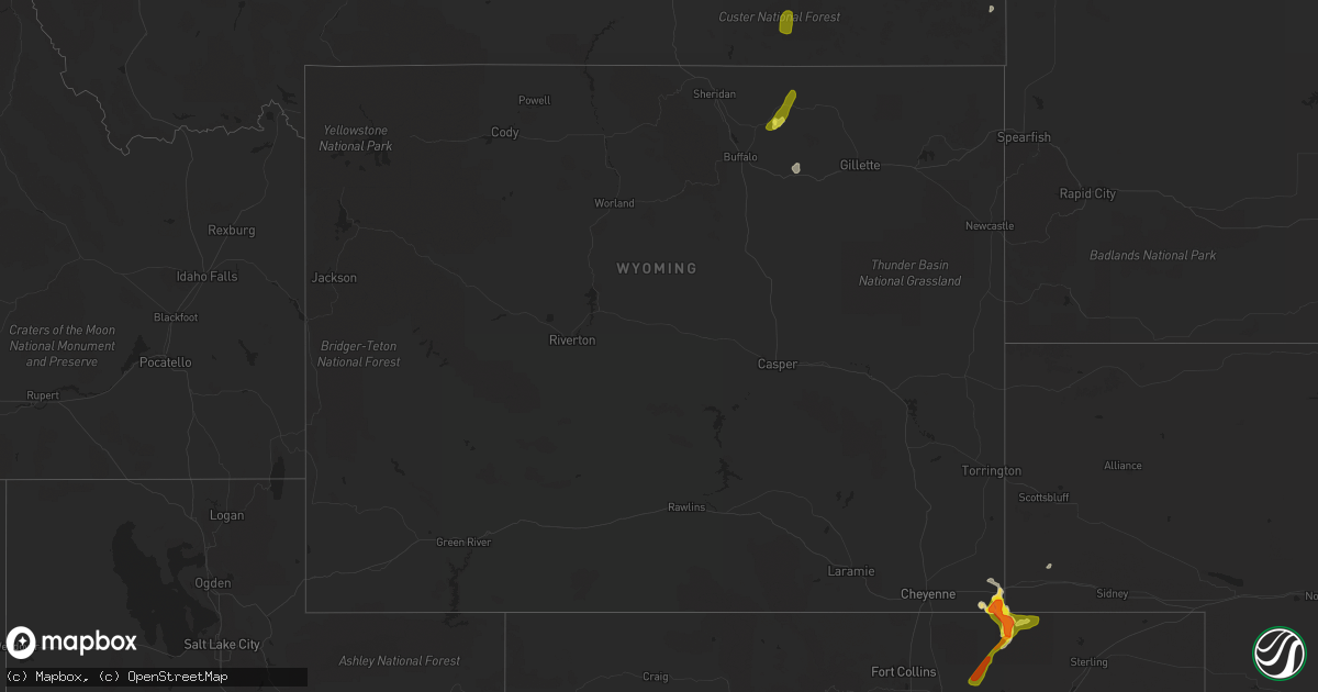
Hail Map in Wyoming on August 22, 2019
Get this storm
August 22 map
$229
one time, instant access
Download today. No call, no setup
Keep the $229
Bought the map and want the full workflow? Apply the entire $229 to a subscription within 7 days. None of it is wasted.
Every map, not just this one
This buys you this map. Subscription and you get every map we run, in the markets you choose from a few cities to whole states to nationwide. Plus real-time alerts the moment a storm fires.
Contact data
Name, contact info, occupancy, even credit band for addresses in the footprint. You go from where it hit to who to call.
Become the source they trust
Unlimited branding weather history reports on demand. You already have the documented answer ready for the property owner, and you are the one who showed up with it.
Property data and RoofTrace estimates
Pull up any address you have got, its value and the exact code rules for that jurisdiction, straight from One Click Code. Then RoofTrace estimates the squares, pitch, and roof value, priced the way you price.
Storm reports in Wyoming
Wyoming
| Date | Description |
|---|---|
| 08/22/20196:44 PM CDT | Severe gust from a combination of weak showers and an outflow from distant thunderstorms. |
| 08/22/20195:09 PM CDT | A local report indicates 1.75 inch wind near 8 SSW PINE BLUFFS |
| 08/22/20193:00 AM CDT | At 759 PM MDT, severe thunderstorms were located along a line extending from 8 miles northeast of Savageton to 16 miles south of Wright, moving east at 20 mph. HAZARD...60 mph wind gusts and quarter size hail. SOURCE...Radar indicated. IMPACT...Hail damage to vehicles is expected. Expect wind damage to roofs, siding, and trees. Locations impacted include... Wright and Reno Junction. |
| 08/22/20192:59 AM CDT | At 758 PM MDT, a severe thunderstorm was located 16 miles north of Powder River Rest Area, which is 23 miles east of Buffalo, moving northeast at 20 mph. HAZARD...60 mph wind gusts and quarter size hail. SOURCE...Radar indicated. IMPACT...Hail damage to vehicles is expected. Expect wind damage to roofs, siding, and trees. This severe thunderstorm will remain over mainly rural areas of northeastern Johnson County. |
| 08/22/20191:36 AM CDT | At 634 PM MDT, a severe thunderstorm was located 22 miles west of Spotted Horse, or 28 miles northeast of Buffalo, moving northeast at 25 mph. HAZARD...60 mph wind gusts and half dollar size hail. SOURCE...Radar indicated. IMPACT...Hail damage to vehicles is expected. Expect wind damage to roofs, siding, and trees. Locations impacted include... Clearmont, Leiter and Arvada. |
| 08/22/20191:34 AM CDT | At 634 PM MDT, a severe thunderstorm was located over Powder River Rest Area, which is 26 miles east of Buffalo, moving northeast at 10 mph. HAZARD...60 mph wind gusts. SOURCE...Radar indicated. IMPACT...Expect damage to roofs, siding, and trees. This severe thunderstorm will be near... Powder River Rest Area around 645 PM MDT.This includes Interstate 90 between mile markers 78 and 95. |
| 08/21/201911:03 PM CDT | At 403 PM MDT, a severe thunderstorm was located 7 miles northwest of Panorama Point, or 28 miles southwest of Kimball, moving east at 10 mph. HAZARD...Half dollar size hail. SOURCE...Radar indicated. IMPACT...Damage to vehicles is expected. Locations impacted include... Pine Bluffs, Panorama Point and Carpenter. This includes the following highways... Interstate 80 in Wyoming between mile markers 391 and 402. Interstate 80 in Nebraska between mile markers 1 and 5. |
| 08/21/20198:00 PM CDT | A local report indicates 1.00 inch wind near 28 E BUFFALO |
| 08/21/20197:40 PM CDT | Quarter size hail and lots of rain. |
All States Impacted by Hail Map on August 22, 2019
Cities Impacted by Hail Map on August 22, 2019
- Ralph, SD
- Colorado Springs, CO
- Hastings, NE
- Shepherd, MT
- Billings, MT
- Huntley, MT
- Buffalo, WY
- Clearmont, WY
- Anadarko, OK
- Apache, OK
- Alda, NE
- Doniphan, NE
- Wood River, NE
- Juniata, NE
- Forsyth, MT
- Pine Bluffs, WY
- Grover, CO
- Carpenter, WY
- Wellston, OK
- Smithsburg, MD
- Rocky Ridge, MD
- Hagerstown, MD
- Thurmont, MD
- Woodsboro, MD
- Sabillasville, MD
- Keymar, MD
- Chandler, OK
- Emmitsburg, MD
- Tecumseh, OK
- Littlestown, PA
- Glasgow, MT
- Macomb, OK
- Yeso, NM
- Cuervo, NM
- Luther, OK
- Otter, MT
- Busby, MT
- Ravenna, NE
- Brule, NE
- Orrtanna, PA
- Raton, NM
- New Raymer, CO
- Fort Sumner, NM
- Glenvil, NE
- Arcadia, OK
- Wanette, OK
- Capulin, NM
- Jones, OK
- Broadus, MT
- Capitol, MT
- Des Moines, NM
- Kimball, NE
- Matador, TX
- Floydada, TX
- Hammond, MT
- Mustang, OK
- Weston, WY
- Whitewater, MT
- Kersey, CO
- Fairfield, PA
- Choctaw, OK
- Asher, OK
- Santa Rosa, NM
- Crosbyton, TX
- Frederick, MD
- Myersville, MD
- Walkersville, MD
- Gettysburg, PA
- Winston Salem, NC
- Union Bridge, MD
- Springer, NM
- Nogales, AZ
- Briggsdale, CO
- Lame Deer, MT
- Arvada, WY
- Saco, MT
- Alzada, MT
- Union City, OK
- Boyes, MT
- Jordan, MT
- Usaf Academy, CO
- Harrah, OK
- Mcloud, OK
- Meeker, OK
- Cyril, OK
- Pauls Valley, OK
- Stratford, OK
- El Reno, OK
- Yukon, OK
- Oklahoma City, OK
- Birney, MT
- Volborg, MT
- Gill, CO
- Edenton, NC
- Tyner, NC
- Knotts Island, NC
- Ballantine, MT
- Worden, MT
- Childress, TX
- Gaithersburg, MD
- Rockville, MD
- Ashton, MD
- Sandy Spring, MD
- Silver Spring, MD
- Olney, MD
- Derwood, MD
- Spencerville, MD
- Fulton, MD
- Brookeville, MD
- Highland, MD
- Burtonsville, MD
- Curtis Bay, MD
- Glen Burnie, MD
- Severn, MD
- Pasadena, MD
- Henderson, MD
- Rock Hall, MD
- Centreville, MD
- Church Hill, MD
- Barclay, MD
- Marydel, MD
- Chestertown, MD
- Felton, DE
- Goldsboro, MD
- Camden Wyoming, DE
- Millington, MD
- Queen Anne, MD
- Ingleside, MD
- Marydel, DE
- Sudlersville, MD
- Greensboro, MD
- Ridgely, MD
- Chesapeake, VA
- Virginia Beach, VA
- Lanexa, VA
- New Kent, VA
- Amelia Court House, VA
- Shacklefords, VA
- Barhamsville, VA
- Hamilton, VA
- Purcellville, VA
- Leesburg, VA
- Ayr, NE
- Blue Hill, NE
- Clay Center, NE
- Edgar, NE
- Fairfield, NE
- Belleville, PA
- Lewistown, PA
- Saylorsburg, PA
- Brodheadsville, PA
- Almyra, AR
- De Witt, AR
- Davidson, OK
- Frederick, OK
- Hollister, OK
- Lyman, SC
- Duncan, SC
- Greer, SC
- Charles Town, WV
- Harpers Ferry, WV
- New York, NY
- Brooklyn, NY
- Jersey City, NJ
- Bellmore, NY
- Wantagh, NY
- Seaford, NY
- West Babylon, NY
- Brentwood, NY
- Bohemia, NY
- Southold, NY
- Laurel, NY
- Smithtown, NY
- Deer Park, NY
- Lindenhurst, NY
- Yaphank, NY
- South Jamesport, NY
- Lake Grove, NY
- Islip Terrace, NY
- West Islip, NY
- Great River, NY
- Shelter Island, NY
- Ronkonkoma, NY
- Centereach, NY
- Patchogue, NY
- Jamesport, NY
- Calverton, NY
- Selden, NY
- Shelter Island Heights, NY
- Massapequa, NY
- Hauppauge, NY
- Babylon, NY
- Cutchogue, NY
- Farmingville, NY
- Islip, NY
- East Islip, NY
- Bay Shore, NY
- Copiague, NY
- Holtsville, NY
- Farmingdale, NY
- Wyandanch, NY
- Oakdale, NY
- Manorville, NY
- Medford, NY
- Brightwaters, NY
- Amityville, NY
- Levittown, NY
- Peconic, NY
- North Babylon, NY
- Greenport, NY
- East Meadow, NY
- Islandia, NY
- Middle Island, NY
- Bethpage, NY
- Wading River, NY
- Central Islip, NY
- Nesconset, NY
- Holbrook, NY
- Mattituck, NY
- Riverhead, NY
- Sayville, NY
- Ridge, NY
- Massapequa Park, NY
- Coram, NY


