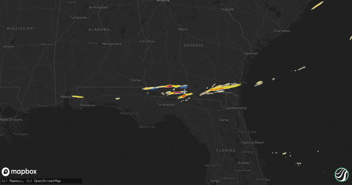
Hail Map on November 9, 2025
Get this storm
November 9 map
$229
one time, instant access
Download today. No call, no setup
Keep the $229
Bought the map and want the full workflow? Apply the entire $229 to a subscription within 7 days. None of it is wasted.
Every map, not just this one
This buys you this map. Subscription and you get every map we run, in the markets you choose from a few cities to whole states to nationwide. Plus real-time alerts the moment a storm fires.
Contact data
Name, contact info, occupancy, even credit band for addresses in the footprint. You go from where it hit to who to call.
Become the source they trust
Unlimited branding weather history reports on demand. You already have the documented answer ready for the property owner, and you are the one who showed up with it.
Property data and RoofTrace estimates
Pull up any address you have got, its value and the exact code rules for that jurisdiction, straight from One Click Code. Then RoofTrace estimates the squares, pitch, and roof value, priced the way you price.
Storm reports
Alabama
| Date | Description |
|---|---|
| 11/09/20258:40 AM CST | Broadcast media reports quarter to half dollar sized hail near the gateswood community in alabama. Report via social media and time estimated by radar. |
Virginia
| Date | Description |
|---|---|
| 11/08/20258:15 PM CST | The 911 call center reported a tree down along i-64 near exit 238 in york county. Time estimated from radar. |
| 11/08/20258:15 PM CST | The 911 call c |
| 11/08/20258:12 PM CST | The 911 call center reported a tree down at 3472 old stage road. Time estimated from radar. |
| 11/08/20258:12 PM CST | 3 trees knocked down at a residence along riverview rd. One tree damaged a kennel. |
| 11/08/20258:06 PM CST | The 911 call center reported a tree down near the intersection of richmond road and diascund reservoir road. Time estimated from radar. |
Georgia
| Date | Description |
|---|---|
| 11/09/20255:20 PM CST | Powerlines reported down along old highway 259. |
| 11/09/20254:57 PM CST | Trees and powerlines were reported down in race pond... Ga. Time was estimated by radar. |
| 11/09/20254:00 PM CST | Power lines down in the north end of lowndes county. |
| 11/09/20254:00 PM CST | Power lines down near valdosta state |
| 11/09/20254:00 PM CST | Power lines down near valdosta state university. |
| 11/09/20253:43 PM CST | Video of hail from wester |
| 11/09/20253:43 PM CST | Video of hail from western cook county on antioch greggs road. |
| 11/09/20253:30 PM CST | Public reported largest hail was about 2 inches in diameter at the owl & moon wedding and events venue at 2818 dry |
| 11/09/20253:30 PM CST | Public reported largest hail was about 2 inches in diameter at the owl & moon wedding and events venue at 2818 dry lake road. |
| 11/09/20253:24 PM CST | Photo of hail from the boston area. |
| 11/09/20253:24 PM CST | Pictures of hail around golf ball size from near boston... Ga. |
| 11/09/20253:24 PM CST | Pictures of hail around golf ball size from near boston... Ga. |
| 11/09/20253:24 PM CST | Pictures of hail around golf ball size from near bost |
| 11/09/20253:20 PM CST | Quarter size hail was reported at the intersection of woodhaven road and enon road. |
| 11/09/20253:20 PM CST | Video of hail estimated at golf ball size from near dixie in brooks county. |
| 11/09/20253:18 PM CST | Report of 1 to 1.25 inch hail in the gatlin creek area. |
| 11/09/20253:15 PM CST | Photo of hail from thomasville. |
| 11/09/20253:06 PM CST | Photo of hail from highway 319 in southern thomas county. |
| 11/09/20252:45 PM CST | Public report of 2 inch hail near ochlocknee with most stones around quarter size. |
| 11/09/20252:45 PM CST | Video from the meigs area. |
| 11/09/20252:43 PM CST | Photo of large hail from north of cairo. |
| 11/09/20252:42 PM CST | Reported at jonina farm at 2501 malloy road. |
| 11/09/20252:38 PM CST | A local report indicates 1.75 inch wind near Spence |
| 11/09/20252:30 PM CST | Dime size with some quarter size mixed in near womble and griner road intersection. |
| 11/09/20252:10 PM CST | In the 3500 vada road area... There were large oak trees down... Power lines down... And some roof damage. |
| 11/09/20252:10 PM CST | In the 3500 vada road |
| 11/09/20252:10 PM CST | In the 3500 vada road area... Th |
| 11/09/20251:58 PM CST | The bainbridge raws station tt665 gusted to 69 mph. |
| 11/09/20251:55 PM CST | Awos station kbge bainbridge. |
| 11/09/20251:43 PM CST | Report of irrigation pivot flipped near highway 84 and highway 310. |
| 11/09/20251:43 PM CST | Photo of fence damage in brinson. |
| 11/09/20251:27 PM CST | Dogwood tree was downed by strong winds. |
Florida
| Date | Description |
|---|---|
| 11/09/20251:10 PM CST | Tree down along highway 71. |
| 11/09/20259:00 AM CST | Broadcast media reports penny to quarter sized hail mainly southwest of molino with images. Report via social media. |
Cities Impacted by Hail Map on November 9, 2025
- Benson, NC
- Angier, NC
- Loxley, AL
- Stapleton, AL
- Daphne, AL
- Robertsdale, AL
- Bay Minette, AL
- Cantonment, FL
- Molino, FL
- Bascom, FL
- Malone, FL
- Greenwood, FL
- Defuniak Springs, FL
- Ponce De Leon, FL
- Donalsonville, GA
- Freeport, FL
- Iron City, GA
- Brinson, GA
- Grand Ridge, FL
- Marianna, FL
- Bainbridge, GA
- Climax, GA
- Sneads, FL
- Whigham, GA
- Cairo, GA
- Pelham, GA
- Ochlocknee, GA
- Meigs, GA
- Coolidge, GA
- Thomasville, GA
- Boston, GA
- Pavo, GA
- Barney, GA
- Dixie, GA
- Moultrie, GA
- Quitman, GA
- Morven, GA
- Adel, GA
- Valdosta, GA
- Statenville, GA
- Homerville, GA
- Fargo, GA
- Monticello, FL
- Waycross, GA
- Manor, GA
- Folkston, GA
- Lake Park, GA
- White Oak, GA
- Nahunta, GA
- Waverly, GA
- Attapulgus, GA
- Waynesville, GA
- Dunnsville, VA
- Greenville, FL
- Madison, FL
- Pinetta, FL
- Williamsburg, VA
- Toano, VA
- Gloucester, VA
- Charles City, VA
- Millsboro, DE
- Frankford, DE