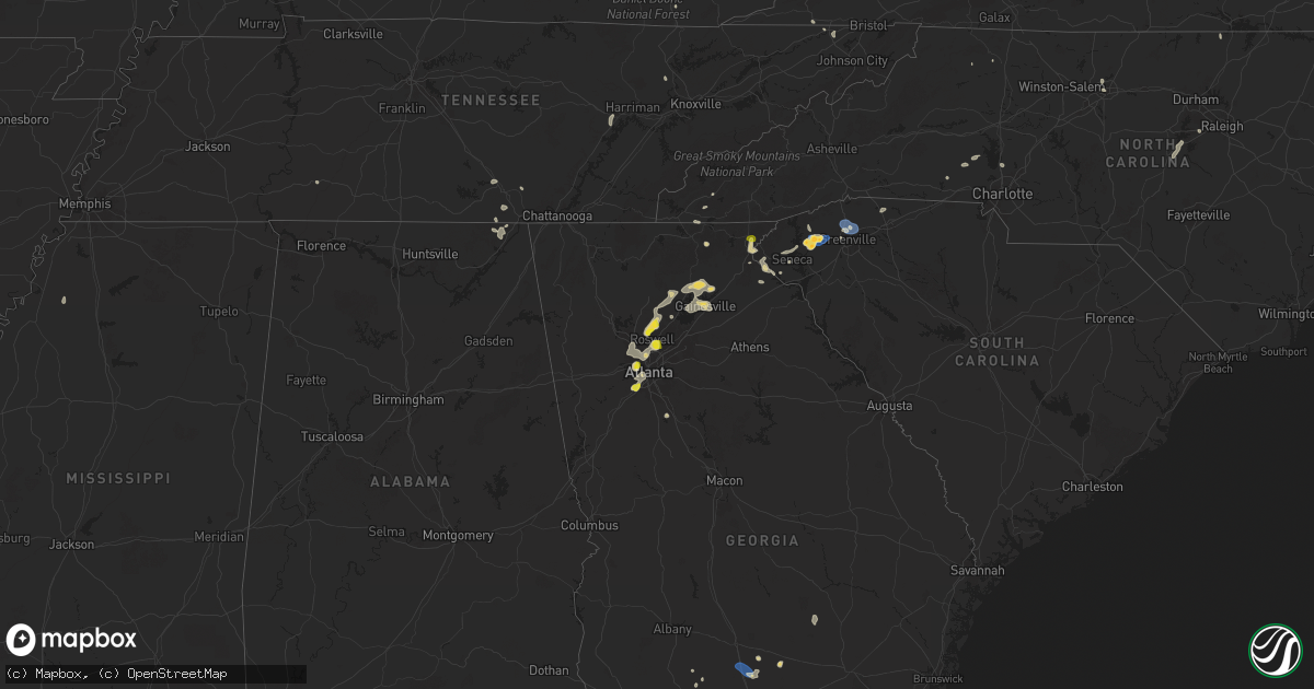
Hail Map on June 26, 2025
Get this storm
June 26 map
$229
one time, instant access
Download today. No call, no setup
Keep the $229
Bought the map and want the full workflow? Apply the entire $229 to a subscription within 7 days. None of it is wasted.
Every map, not just this one
This buys you this map. Subscription and you get every map we run, in the markets you choose from a few cities to whole states to nationwide. Plus real-time alerts the moment a storm fires.
Contact data
Name, contact info, occupancy, even credit band for addresses in the footprint. You go from where it hit to who to call.
Become the source they trust
Unlimited branding weather history reports on demand. You already have the documented answer ready for the property owner, and you are the one who showed up with it.
Property data and RoofTrace estimates
Pull up any address you have got, its value and the exact code rules for that jurisdiction, straight from One Click Code. Then RoofTrace estimates the squares, pitch, and roof value, priced the way you price.
States Impacted by Hail Map on June 26, 2025
Storm reports
Pennsylvania
| Date | Description |
|---|---|
| 06/26/20256:27 PM CDT | Trees down and blocking the roadway of s jefferson street. |
| 06/26/20256:21 PM CDT | Trees and wires down on the roadway on point road. |
| 06/26/20256:06 PM CDT | Power outages and wires down reported west of oxford. Time estimated. |
| 06/26/20255:50 PM CDT | Multiple trees and power poles snapped. Time estimated from radar. |
| 06/26/20255:47 PM CDT | Tree damage and power poles blown down. Time estimated from radar. |
| 06/26/20255:34 PM CDT | Reports of wires down along erskine road. Time estimated from radar. |
| 06/26/20255:30 PM CDT | Wires down. |
| 06/26/20255:30 PM CDT | Tree down on wires on pennsy rd near providence twp line. |
| 06/26/20255:30 PM CDT | Tree down on wires on pennsy rd near providence tw |
| 06/26/20255:25 PM CDT | Report of a tree falling on power lines causing the lines to go down and close frye avenue. Time estimated from radar. |
| 06/26/20255:20 PM CDT | 4 to 5 trees down. Time estimated via radar. |
| 06/26/20255:05 PM CDT | Multiple trees and wires down across lancaster city and manor twp. |
| 06/26/20255:05 PM CDT | Tree on wires. Time estimated from radar. |
| 06/26/20254:58 PM CDT | Reports of a tree down on power lines causing them to spark. Time estimated from radar. |
| 06/26/20254:55 PM CDT | Trees down on zion road. Time estimated from radar. |
| 06/26/20254:40 PM CDT | Trees and wires down on chapel hill road. Time estimated from radar. |
| 06/26/20254:30 PM CDT | Tree limbs down along 40th st in lawrenceville. |
| 06/26/20254:25 PM CDT | Tree down on vilsack road. Time estimated via radar. |
| 06/26/20254:19 PM CDT | Several trees down. Chicken coop blown over. |
| 06/26/20254:15 PM CDT | Tree and wires down on packing house rd near pigeon hill rd. |
| 06/26/20254:11 PM CDT | A report of wires down near the 100 block of thompson hill rd. Time estimated from radar. |
| 06/26/20254:10 PM CDT | Multiple reports of trees down across raccoon creek state park near the beach. Time estimated from radar. |
| 06/26/20254:00 PM CDT | Roofing material removed from a barn. Time estimated from radar. |
| 06/26/20254:00 PM CDT | Roofing material removed from farm outbuilding. Time estimated from radar. |
| 06/26/20254:00 PM CDT | Multiple trees snapped and uprooted. Time estimated from radar. |
| 06/26/20254:00 PM CDT | Power poles blown down. Time estimated from radar. |
| 06/26/20253:50 PM CDT | Multiple houses with roof damage and windows blown out. Time estimated from radar. |
| 06/26/20253:50 PM CDT | Multiple trees uprooted. Time estimated from radar. |
| 06/26/20253:40 PM CDT | Wires down. Time estimated from radar. |
| 06/26/20252:50 PM CDT | Tree down blocking lane on 6500 block of pa 147. |
| 06/26/20252:43 PM CDT | Wires down along bridge street. |
| 06/26/20252:38 PM CDT | Tree down on wires at east lutton street and cunningham avenue. |
| 06/26/20252:38 PM CDT | Tree down near squaw run road and ellwood road. |
| 06/26/20252:09 PM CDT | Corrects previous tstm wnd dmg report from 1 se new castle. Tree down on wires at east lutton street and cunningham avenue. |
| 06/26/20252:09 PM CDT | Wires reported down along centertown road. |
| 06/26/20251:40 PM CDT | Corrects previous flash flood report from 3 w fredonia to tstm wnd dmg. Tree down on mercer rd and partially blocking lane. |
| 06/25/20258:20 PM CDT | Trees down on wires meadow mountain drive. |
| 06/25/20258:18 PM CDT | Trees down on wires on meadow ground road. |
| 06/25/20257:39 PM CDT | Multiple trees down in the area of n clear ridge road in dublin township. |
| 06/25/20257:27 PM CDT | Trees down on wires. |
Nebraska
| Date | Description |
|---|---|
| 06/26/20256:50 PM CDT | A local report indicates 1.00 inch wind near 2 NW Du Bois |
North Carolina
| Date | Description |
|---|---|
| 06/26/20256:45 PM CDT | Tree down at 4000 lower river rd. |
| 06/26/20256:40 PM CDT | Duke energy reported power outage caused by fallen trees or limbs damaging equipment. |
| 06/26/20255:46 PM CDT | Corrects time of previous tstm wnd dmg report from 2 w enochville. Multiple power poles down on wright road west of enochville. Time estimated from radar. |
| 06/26/20255:43 PM CDT | Corrects previous tstm wnd dmg report from 2 w enochville. Multiple power poles down on wright road west of enochville. Time estimated from radar. |
| 06/26/20255:19 PM CDT | Multiple power poles down on wright road west of enochville. Time estimated from radar. |
| 06/26/20254:46 PM CDT | Fallen trees or limbs caused power outage on crescent dr. Time estimated from radar. |
| 06/26/20254:45 PM CDT | Tree down at 4200 bell orchard dr. |
| 06/26/20254:45 PM CDT | Tree down at 4490 baylor st. |
| 06/26/20254:45 PM CDT | Tree down on air harbor rd.... Between quail ridge dr. And bass chapel rd. |
| 06/26/20254:33 PM CDT | A couple of trees were reported down in the town of wentworth north carolina in rockingham county. |
| 06/26/20254:19 PM CDT | 1 tree down off hope beasley road in sandy ridge north carolina. |
| 06/26/20254:10 PM CDT | Several trees were reported down by the 911 call center in madison north carolina in rockingham county. |
| 06/26/20252:18 PM CDT | Trees down along taylor street. |
| 06/26/20252:09 PM CDT | Large tree blown down on home damaging part of it. 6 to 8 trees down. |
| 06/26/20252:09 PM CDT | Microburst that occurred within a thunderstorm. Significant damage to a home after a tree fell on it and several other shed and carports damaged. Hundreds of trees down |
| 06/26/20252:09 PM CDT | Corrects previous tstm wnd dmg report from 2 se benham. Large tree blown down on home damaging part of it. 6 to 8 trees down. |
| 06/26/20252:09 PM CDT | Photos from emergency manager showed crops flattened and trees snapped in one direction along and near the intersection of cool springs church rd and preacher field rd. |
| 06/26/20251:25 PM CDT | Tree down and blocking zion hill rd. |
| 06/25/20257:38 PM CDT | Large tree down on williams street near target. |
| 06/25/20257:38 PM CDT | Corrects previous tstm wnd dmg report from 2 nw apex. Large tree down on powerlines on williams street near target. |
| 06/25/20257:03 PM CDT | Tree down near train tracks. |
Oklahoma
| Date | Description |
|---|---|
| 06/26/20255:30 PM CDT | Trees down on richland road between southwest 15th and reno. |
Missouri
| Date | Description |
|---|---|
| 06/26/20256:24 PM CDT | Downed tree limbs and wires near phelps road. Time estimated from radar. |
| 06/26/20256:14 PM CDT | Downed wires near 24th street. Time estimated from radar. |
| 06/26/20256:13 PM CDT | Social media report of a downed tree in the eastwood hills area. Time estimated from radar. |
| 06/26/20256:12 PM CDT | Downed tree at 55th and troost. Time estimated from radar. |
| 06/26/20256:09 PM CDT | Downed wires near 61st street. Time estimated from radar. |
| 06/26/20256:08 PM CDT | Mping report of downed tree limbs near 65th street. Time estimated from radar. |
| 06/26/20256:08 PM CDT | Several reports of downed trees and wires near indian village. Time estimated from radar. |
| 06/26/20256:06 PM CDT | Several reports of downed trees and wires near gregory boulevard. Time esti |
| 06/26/20256:06 PM CDT | Video of large tree snapped toward the base in waldo. |
| 06/26/20256:06 PM CDT | Several reports of downed trees and wires near gregory boulevard. Time estimated from radar. |
| 06/26/20256:05 PM CDT | 1-2 tree limbs down about 8 inches in diameter. |
| 06/26/20255:37 PM CDT | Downed wires near 116th terrace. Time estimated from radar. |
| 06/26/20255:23 PM CDT | Downed wires near route h. Time estimated from radar. |
| 06/26/20255:22 PM CDT | Damage and blown debris at a construction site near smithville lake. Time estimated from radar. |
| 06/26/20255:15 PM CDT | Downed limbs and wires near kirk road. Time estimated from radar. |
| 06/26/20255:15 PM CDT | Trees downed across stewartsville. |
| 06/26/20255:13 PM CDT | Downed wires north of 188th street. Time estimated from radar. |
| 06/26/20255:05 PM CDT | Downed tree and wires near 120th road. Time estimated from radar. |
| 06/26/20255:05 PM CDT | Mci asos. |
| 06/26/20255:01 PM CDT | Social media report of several large trees snapped west of kci airport from a microburst. Time estimated from radar. |
| 06/26/20254:57 PM CDT | Multiple reports of tree limbs and wires down near the platte city area. Time estimated from radar. |
| 06/26/20254:51 PM CDT | Several reports of downed limbs and wires near ode road. Time estimated from radar. |
| 06/26/20254:49 PM CDT | Downed tree near whitson road and 80th road. Time estimated from radar. |
| 06/26/20254:49 PM CDT | Downed tree and wires near 82nd road. Time estimated from radar. |
| 06/26/20254:48 PM CDT | Several reports of downed power poles and wires in northeastern buchanan... Southwestern dekalb... And northwestern clinton counties. Time estimated from radar. |
| 06/26/20254:47 PM CDT | Downed tree near u.s. Highway 169 and 75th road. Time estimated from radar. |
| 06/26/20254:43 PM CDT | Social media report of several downed trees and limbs north of agency. Time estimated from radar. |
| 06/25/20259:47 PM CDT | Asos station kstj st. Joseph. |
| 06/25/20257:37 PM CDT | Social media photo of a large tree downed south of unionville. Time estimated from radar. |
Tennessee
| Date | Description |
|---|---|
| 06/26/20256:30 PM CDT | Trees down. |
Florida
| Date | Description |
|---|---|
| 06/26/20255:11 PM CDT | Tree down. |
| 06/26/20254:52 PM CDT | Small tree down with two reports of wires down nearby as well. |
| 06/26/20254:30 PM CDT | Tree down. |
| 06/26/20254:27 PM CDT | Tree down. |
| 06/26/20253:25 PM CDT | Utility company reported downed trees and power poles and lines in gulf county. Timing approximated by radar and location by the utility company outage map. |
| 06/26/20252:40 PM CDT | Marion county 911 dispatch had a report of a tree snapped that fell onto a neighbors home near the intersection of se 105th terrace and se 157th lane in the sunset harb |
Texas
| Date | Description |
|---|---|
| 06/26/20255:03 PM CDT | Mesonet station 18 lamesa 2se. |
| 06/26/20251:05 PM CDT | Mesonet station twb23 12.1 se belding |
| 06/25/20259:23 PM CDT | Midland county emergency manager reports many power lines down near scr 1200 and w |
| 06/25/20259:23 PM CDT | Midland county emergency manager reports many power lines down near scr 1200 and wcr 125 and along rankin highway south of wcr 140. This is all in the cotton flat area |
| 06/25/20259:23 PM CDT | Midland county emergency manager reports many power lines down near scr 1200 and wcr 125 and along rankin highway south of wcr 140. This is all in the cotton flat area |
| 06/25/20259:23 PM CDT | Midland county emergency manager reports many power lines down near scr 1200 and wcr 125 and along rankin highway south of wcr 140. This is |
| 06/25/20257:48 PM CDT | Corrects previous tstm wnd dmg report from cotton flat. Midland county emergency manager reports many power lines down near scr 1200 and wcr 125 and along rankin highwa |
Montana
| Date | Description |
|---|---|
| 06/26/20255:00 PM CDT | Wolf point nw. |
| 06/26/20254:57 PM CDT | Public report |
| 06/26/20254:57 PM CDT | Public report with photo via facebook. |
| 06/26/20254:45 PM CDT | Hail up to the size of quarters in addition to heavy rain. |
| 06/25/20259:40 PM CDT | Mosby se |
| 06/25/20258:50 PM CDT | Winnett southwest |
| 06/25/20257:10 PM CDT | Pea to quarter sized hail. |
South Carolina
| Date | Description |
|---|---|
| 06/26/20254:30 PM CDT | Corrects time of previous tstm wnd dmg report from 2 se walhalla. Trees down at church street and w union rd. |
| 06/26/20254:20 PM CDT | Trees down at church street and w union rd. |
| 06/26/20254:04 PM CDT | Social media report of trees down in the norris area. |
| 06/26/20253:54 PM CDT | Powerlines down on roadway. |
| 06/26/20253:49 PM CDT | Powerlines down on roadway and power pole on fire. |
| 06/26/20253:47 PM CDT | Trees down on belle shoals rd. |
| 06/26/20253:45 PM CDT | At least 15 trees down along and south of hwy 183 east of six mile. |
| 06/26/20253:44 PM CDT | Social media video shows multiple hail dents on a vehicle in pickens. |
| 06/26/20253:19 PM CDT | Powerlines down on roadway. |
| 06/26/20253:16 PM CDT | Large tree uprooted on black snake rd. Time estimated. |
Virginia
| Date | Description |
|---|---|
| 06/26/20256:37 PM CDT | Reports of multiple trees down near bentonville. |
| 06/26/20256:26 PM CDT | Tree down near the corner of richmond and greene roads. |
| 06/26/20256:24 PM CDT | Corrects previous tstm wnd dmg report from troutville. 911 call center reported multiple trees down in the town of troutville in botetourt county virginia. |
| 06/26/20256:06 PM CDT | Tree down along hebron valley rd off of us 29 |
| 06/26/20255:59 PM CDT | 911 call center reported multiple trees down in the town of troutville in botetourt county virginia. |
| 06/26/20255:59 PM CDT | Tree down along forbes mill road. |
| 06/26/20255:37 PM CDT | Multiple trees were reported down in the town of blue ridge in botetourt county virginia. |
| 06/26/20255:37 PM CDT | Multiple trees were reported down in the town of |
| 06/26/20255:35 PM CDT | One tree down on hwy 903 in bracey. |
| 06/26/20255:35 PM CDT | Trees down in shenandoah national park north of big meadows. |
| 06/26/20255:30 PM CDT | Tree down along east laurel ln |
| 06/26/20255:19 PM CDT | Thunderstorm winds blew down numerous trees along route 100 from staffordsville to bane to pearisburg. |
| 06/26/20254:43 PM CDT | A large tree is down blocking the entire intersection of meadow creek road and youngs lane in montgomery county virginia. |
| 06/26/20254:28 PM CDT | 911 call center reported a downed tree blocking the entire roadway in the intersection of prices fork road and brightwood manor drive. |
| 06/26/20254:09 PM CDT | Tree blown down across anderson mill road. |
| 06/26/20253:59 PM CDT | Huge tree down along reserve blvd. |
| 06/26/20253:57 PM CDT | Tree down blocking intersection of meadwood trail and tanyard road. |
| 06/26/20253:56 PM CDT | A tree was reported down by the 911 call center off meadow creek road near the town of galax in grayson county virginia. |
| 06/26/20253:51 PM CDT | Tree was reported down off grayson parkway near the town of galax in grayson county virginia. |
| 06/26/20253:39 PM CDT | Tree down near intersection of old liberty drive and mount olivet road. |
| 06/26/20253:35 PM CDT | Tree downed onto a line at cold harbor rd at i-295. |
| 06/26/20253:35 PM CDT | Multiple trees and power lines down in the vicinity of dill rd and us360. |
| 06/26/20252:59 PM CDT | Tree down blocking odell road. |
| 06/26/20252:32 PM CDT | Tree down blocking both lanes of mary hunter drive. |
| 06/26/20251:20 PM CDT | Multiple trees down. |
| 06/26/202511:57 AM CDT | Two trees down. |
| 06/26/202511:31 AM CDT | Several trees down. |
| 06/25/20259:11 PM CDT | Numerous trees down in the dumfries area. |
| 06/25/20258:02 PM CDT | Numerous trees down near manassas. |
| 06/25/20257:57 PM CDT | Two trees down near the intersection of dumfries rd and wellington rd. |
| 06/25/20257:51 PM CDT | Thunderstorm winds blew down one tree near the intersection of mciver ferry road and evan davis drive. |
| 06/25/20257:26 PM CDT | Thunderstorm winds blew down one tree near the intersection of marysville road and covered bridge road. |
| 06/25/20257:13 PM CDT | Tree downed by thunderstorm winds... Landing on a power line in the front yard of a residence on straightstone road. |
Kansas
| Date | Description |
|---|---|
| 06/26/20256:49 PM CDT | Downed wires near route 68. Time estimated from radar. |
| 06/26/20256:28 PM CDT | Several reports of downed wires and power outages west of paola. Time based on dispatch report and confirmed from radar. |
| 06/26/20256:05 PM CDT | Tree limbs downed at ward parkway shopping center on state line. |
| 06/26/20256:04 PM CDT | Several large trees down on ward parkway center at 88th and state line. |
| 06/26/20256:03 PM CDT | Social media report of a downed tree on belinder avenue. Time estimated from radar. |
| 06/26/20256:02 PM CDT | Several trees down near 95th and mission. Time estimated from radar. |
| 06/26/20256:02 PM CDT | Multiple reports of downed trees and wires in prairie village. Time estimated from radar. |
| 06/26/20256:01 PM CDT | Large tree uprooted. Time estimated from radar. |
| 06/26/20256:00 PM CDT | Mping report of downed tree limbs near foster lane. Time estimated from radar. |
| 06/26/20255:59 PM CDT | Delayed report of large tree limbs downed near 85th and antioch in overland park. |
| 06/26/20255:59 PM CDT | Downed tree and wires near grandview lane. Time estimated from radar. |
| 06/26/20255:59 PM CDT | Downed tree and wires near osage avenue. Time estimated from radar. |
| 06/26/20255:58 PM CDT | Trees down along wooden fence at 95th and antioch roads. |
| 06/26/20255:37 PM CDT | Downed tree and wires near orchard street. Time estimated from radar. |
| 06/26/20255:33 PM CDT | Mping report of downed trees near leavenworth road. Time estimated from radar. |
| 06/26/20255:26 PM CDT | Very large mature tree uprooted and fell onto house at the 1500 block of north 78th street. |
| 06/26/20255:25 PM CDT | Several social media and spotter reports and photos of trees and power poles down near state avenue between 78th and 94th streets. Time estimated from radar. |
| 06/26/20255:24 PM CDT | Social media report and photos of several downed tree limbs near 78th and i-70. Time estimated from radar. |
| 06/26/20255:20 PM CDT | Mping report of downed tree limbs near 71st terrace. Time estimated from radar. |
| 06/26/20255:19 PM CDT | Trees down on 72nd and riverview near the turner diagonal. |
| 06/26/20255:15 PM CDT | Trees downed near state ave & 90th street east of the legends. |
| 06/26/20255:14 PM CDT | Mping report of downed tree limbs near state avenue. Time estimated from radar. |
| 06/26/20254:41 PM CDT | Large tree broke in half at k92 and lecompton. |
| 06/26/20254:41 PM CDT | Corrects previous tstm wnd dmg report from 1 ne easton to 1 w leavenworth. Large tree broke in half at k92 and lecompton. |
| 06/26/20254:41 PM CDT | Corrects previous tstm wnd dmg report from 1 ne easton to 1 w leavenworth. Lar |
| 06/26/20254:41 PM CDT | Tree down with 3 branches approximately 24 tall and approximately 1 wide. |
| 06/26/20254:37 PM CDT | Several reports of downed tree limbs and wires in the leavenworth area. Time estimated from radar. |
| 06/26/20254:35 PM CDT | Downed wires near county road 29. Time estimated from radar. |
| 06/26/20254:18 PM CDT | A local report indicates 60 MPH wind near 2 SSW Lowemont |
| 06/26/20254:16 PM CDT | Downed wires near 206th road. Time estimated from radar. |
| 06/25/20258:31 PM CDT | On us36 at the nemaha / brown co line. |
Minnesota
| Date | Description |
|---|---|
| 06/26/20251:29 PM CDT | Trained spotter confirmed tornado on the ground 3 miles west of hayward. |
| 06/26/20251:20 PM CDT | Downed trees and powerlines... Possible tornado damage. Time estimated from radar. |
Michigan
| Date | Description |
|---|---|
| 06/26/202512:36 PM CDT | Emergency manager reported trees/limbs downed near the town of moscow on milnes road in hillsdale county in michigan due to thunderstorm winds. Time is radar estimated. |
| 06/26/202512:36 PM CDT | Report of a downed powerline |
Illinois
| Date | Description |
|---|---|
| 06/26/20256:59 PM CDT | Tree down on wires and wires on fire. Time estimated. |
| 06/26/20256:59 PM CDT | Half dozen 911 calls for trees down in batavia. Time estimted. |
| 06/26/20256:50 PM CDT | Power lines blown down on harter road. Time estimated. |
| 06/26/20256:49 PM CDT | Photos shared show two large tree limbs snapped off a tree near lovell street. Time estimated. |
| 06/25/20257:27 PM CDT | Light pole blown down at tekler and route 14. Several 3 to 4 inch tree limbs blown down. One 8 inch diameter tree uprooted. Time estimated. |
| 06/25/20257:22 PM CDT | Photos shared on social media showed half of a tree split and blown down... A deck awning partially collapsed and small tree limbs blown down. A tree was also reported |
| 06/25/20257:18 PM CDT | Trees blown down at route 72 and romke road. Time estimated. |
| 06/25/20257:09 PM CDT | Trees... Tree limbs and power lines blown down in crystal lake. Time estimated. |
| 06/25/20257:05 PM CDT | Photo shared of a small tree limb blown down near geneva drive and kirk road. |
| 06/25/20257:05 PM CDT | Tree limbs blown down into the roadway on green road. Multiple power outages reported in the area. Time estimated. |
Ohio
| Date | Description |
|---|---|
| 06/26/20256:30 PM CDT | Large tree uprooted and felled partially onto a home. Time estimated via radar. |
| 06/26/20255:20 PM CDT | Tree down across the 1200 block of north water street in uhrichsville. Time estimated via radar. |
| 06/26/20253:30 PM CDT | Fire dept responded to a report of a tree down along price street. Time estimated from radar. |
| 06/26/20253:23 PM CDT | One large healthy pine tree downed at kenwood road and galbraith road. One large maple tree downed on power lines at kenwood road and kugler mill road. |
| 06/26/20253:15 PM CDT | Tree down near intersection of gambier st/boyton st. Time estimated via radar. |
| 06/26/20251:54 PM CDT | 10 inch tree branch down near east main st. And eastmoor blvd in bexley. Time estimated from radar data. |
| 06/26/20251:33 PM CDT | South bound lanes of us-23 blocked by large tree and other downed branches. Time estimated from radar. |
| 06/26/20251:32 PM CDT | Broadcast media relayed reports of thunderstorm wind damage of a barn with the doors blown off and a silo now leaning off of the concrete pad near the town of delta in |
| 06/26/20251:32 PM CDT | Trained spotter reports thunderstorm wind damage in the form of 3 semi trucks blown over on the ohio turnpike near county road 5-2 near the town of delta in fulton coun |
Georgia
| Date | Description |
|---|---|
| 06/26/20255:34 PM CDT | Trees fell on several roads in grady county. |
| 06/26/20255:16 PM CDT | There were three reports of trees down in thomas county. |
| 06/26/20254:45 PM CDT | Quarter-sized hail reported near mableton. |
| 06/26/20254:38 PM CDT | Report of 1-inch hail at james jackson pkwy and bolton rd nw. |
| 06/26/20254:18 PM CDT | Measured 60.2 mph wind gust with rooftop anemometer. |
| 06/26/20254:18 PM CDT | A local report indicates 60 MPH wind near 1 E Laconte |
| 06/26/20254:05 PM CDT | Report from mping: quarter |
| 06/26/20254:03 PM CDT | Report of 1-inch hail in dunwoody. |
| 06/26/20254:03 PM CDT | Report of 1-inch hail at ison rd ne and roswell rd. |
| 06/26/20254:03 PM CDT | 1 inch hail reported at n peachtree rd. & starcross ct. |
| 06/26/20254:02 PM CDT | Tree reported down on dunwoody club way near the intersection of dunwoody club dr. |
| 06/26/20254:00 PM CDT | Power pole and lines downed near the intersection of dunwoody club dr and happy hollow rd... Leading to power outages in the neighborhood. |
| 06/26/20254:00 PM CDT | Picture with hail next to quarter from public near the intersection of n peachtree rd and starcross ct. |
| 06/26/20253:50 PM CDT | Tree down with powerlines down as well along the 2700 block of cox rd. |
| 06/26/20253:23 PM CDT | Report of 1-inch hail at birmingham rd and freemanville rd. |
| 06/26/20253:09 PM CDT | Couple of trees down near the 100 block of spring street. |
| 06/26/20253:09 PM CDT | Tree down at 800 block of chattahoochee st. |
| 06/26/20253:08 PM CDT | Tree down on gaines mill rd near shady lane drive. |
| 06/26/20253:08 PM CDT | Tree down at 1800 block of tulip dr. |
| 06/26/20253:07 PM CDT | Report via social media that a tree fell and took out a fence and power lines. |
| 06/26/20252:33 PM CDT | Tree down at east lake dr and antioch campground rd. |
| 06/26/20252:33 PM CDT | Report of a tree on a home on river sound ln. |
| 06/26/20252:20 PM CDT | Lowndes county dispatch reported trees down onto powerlines along gornto road. Timing estimated by radar. |
| 06/26/20252:19 PM CDT | Multiple trees down in old dahlonega. |
| 06/26/20252:19 PM CDT | Tree down at thompson bridge rd and mt vernon rd. |
| 06/26/20252:19 PM CDT | Multiple trees down near red oak flats rd. |
| 06/26/20252:05 PM CDT | Tree down at dahlonega hwy and clermont hwy. |
| 06/26/20252:04 PM CDT | Tree down at keinmer rd and ransom free rd. |
| 06/26/20251:54 PM CDT | Tree down at bowen bridge rd. |
| 06/26/20251:50 PM CDT | County communications reported trees and powerlines downed. Time estimated from radar. |
| 06/26/202512:04 PM CDT | Social media report of several large limbs down in the clayton area. |
Maryland
| Date | Description |
|---|---|
| 06/26/20256:39 PM CDT | Multiple trees down in rising sun including on route 1. |
| 06/26/20256:26 PM CDT | Tree down near the intersection of court house drive and martha bush drive. |
| 06/26/20256:26 PM CDT | Numerous trees down near conowingo... Md. |
| 06/26/20256:00 PM CDT | Power lines down onto two unoccupied vehicles at the intersection of gregory st. And snure rd. |
| 06/26/20255:57 PM CDT | Multiple trees reported down between pylesville ant the state line. |
| 06/26/20255:50 PM CDT | One foot diameter tree branch snapped off... Blocking the road... On the 13000 block of overton ln. |
| 06/26/20255:35 PM CDT | Tree down near the intersection of norrisville rd and harford creamery rd. |
| 06/26/20255:06 PM CDT | Tree down near the 16800 block of ridge road. |
| 06/26/20254:51 PM CDT | Tree down near the intersection of brickstore rd and upper beckleysville rd. |
| 06/26/20254:50 PM CDT | Tree down near the intersection of falls rd and grave run rd. |
| 06/26/20254:21 PM CDT | Tree down near the intersection of bankard rd and grand valley road. |
| 06/26/20252:30 PM CDT | Tree downed at intersection of campbelltown road and pitts rd. Time is radar-estimated. |
| 06/25/20259:00 PM CDT | Tree do |
| 06/25/20259:00 PM CDT | Tree down near the intersection of deep cove rd and central ave. |
| 06/25/20258:57 PM CDT | Tree down near the intersection of friendship rd and old solomons island rd. |
| 06/25/20258:57 PM CDT | Tree down near the intersection of friendship rd and old sol |
| 06/25/20258:05 PM CDT | Wires down. Time estimated from radar. |
Iowa
| Date | Description |
|---|---|
| 06/26/20254:30 PM CDT | Hardwood tree damage near grays lake. Delayed report via tv media. Time estimated from radar. |
| 06/26/20254:20 PM CDT | From personal weather station. |
| 06/26/20254:05 PM CDT | Delayed report. Time estimated from radar. |
| 06/26/20253:57 PM CDT | Only known damage is to fields. Time estimated from radar. |
| 06/26/20253:53 PM CDT | Delayed report. Relayed via social media. Time estimated from radar. Estimated on the ground for around 3 miles. No known damage. |
| 06/26/20252:15 PM CDT | Branches... Trees... And powerlines down. According to alden fire department. |
| 06/25/20257:57 PM CDT | A local report indicates 60 MPH wind near 1 SE Julien |
West Virginia
| Date | Description |
|---|---|
| 06/26/20256:55 PM CDT | Large tree down along blair mountain highway east of stollings. |
| 06/26/20256:55 PM CDT | Tree down along lick creek road west of danville. |
| 06/26/20256:45 PM CDT | Tree down reported in phico. |
| 06/26/20256:25 PM CDT | Report of a tree down along us 119 near frye drive. |
| 06/26/20255:55 PM CDT | Skywarn spotter reported several trees down along west virginia highway 20 in summers county. |
| 06/26/20255:45 PM CDT | Tree down blocking a lane in hensley. |
| 06/26/20255:43 PM CDT | Three trees down in the davy area. |
| 06/26/20252:30 PM CDT | A couple trees down and wires down on highland ridge road. |
| 06/26/20252:04 PM CDT | Tree reported down into powerlines on n washington street. |
| 06/26/20252:04 PM CDT | Multiple trees reported down along cold run valley road near cacapon road. |
| 06/25/20257:25 PM CDT | Tree reported down on wv 37 at marina road near east lynn lake. |
Alabama
| Date | Description |
|---|---|
| 06/26/20255:56 PM CDT | Tree down across lynnbrook dr. |
Indiana
| Date | Description |
|---|---|
| 06/26/20253:50 PM CDT | Reports of trees and large branches down in churubusco. |
| 06/26/20252:53 PM CDT | Asos station kgsh goshen. |
| 06/26/202512:47 PM CDT | Pictures showing barn destroyed on county road 800 north. Time estimated from radar. |
| 06/25/20258:05 PM CDT | Photo shared on social media showed a 4 inch diameter tree limb and another 6 inch diameter tree limb blown down near east 108th street and park street. |
Kentucky
| Date | Description |
|---|---|
| 06/26/20255:29 PM CDT | Trees down on newcut rd. |
| 06/26/20255:08 PM CDT | Trees and power lines down in belleview. |
| 06/26/20255:06 PM CDT | Tree down on roadway near intersection of mason headley rd and versailles rd. |
| 06/26/20255:00 PM CDT | Trees down & other wind damage - along newtown pike. |
| 06/26/20254:55 PM CDT | Some 6 to 8 inch diameter trees and limbs down across mercer rd. Several sections of chain link fencing blown over. |
| 06/26/20254:44 PM CDT | Wind gusts of 50 kts reported at sdf international airport. |
| 06/26/20254:31 PM CDT | Corrects previous tstm wnd gst report from 1 n louisville intl airport. Corrects previous tstm wnd gst report from 1 n louisville intl airport for wind speed. Wind gust |
| 06/26/20254:31 PM CDT | Corrects previous tstm wnd gst report from 1 n louisville int'l airport. Wind gusts of 50 kts reported at sdf international airport. |
| 06/26/20254:29 PM CDT | Corrects previous tstm wnd dmg report from 2 wnw louisville intl airport for time of occurrence. Trees down on newcut rd. |
| 06/26/20254:26 PM CDT | Tree in roadway near baker lane. |
| 06/26/20254:26 PM CDT | Power out near intersection of southside drive and strawberry lane - media reported. |
| 06/26/20254:26 PM CDT | Power lines down - report from media. |
| 06/26/20254:25 PM CDT | Power lines down near palatka rd and southdale rd. |
| 06/26/20254:24 PM CDT | Ksdf asos measured 58 mph at 524 pm edt. |
| 06/26/20254:19 PM CDT | Tree on car in fairdale - report through media. |
| 06/26/20253:49 PM CDT | Trees reported down in the 500 block of ky-1428 east of prestonsburg. Time estimated via radar. |
| 06/26/20253:44 PM CDT | Trees reported down along north central avenue behind the wendys in prestonsburg. Time estimated via radar. |
| 06/26/20253:29 PM CDT | Downed trees in the 1100 block of left fork little paint road. Time estimated via radar. |
| 06/26/20252:00 PM CDT | Report of multiple trees... Powerlines... And a utility pole down around goshen lane. Time estimated from radar. |
| 06/26/202512:25 PM CDT | Downed tree on a home along radio hill road in manchester. Time estimated via radar. Report came from social media and was relayed to us via slack. |
Cities Impacted by Hail Map on June 26, 2025
- Waynesboro, TN
- Church Hill, TN
- Kingsport, TN
- Gate City, VA
- Duffield, VA
- Clayton, GA
- Tiger, GA
- Lakemont, GA
- Long Creek, SC
- Hays, NC
- Jonesville, MI
- McGrady, NC
- Washington Court House, OH
- Jerome, MI
- Clarksburg, OH
- New Holland, OH
- Springfield, OH
- Cement City, MI
- Addison, MI
- Orient, OH
- Circleville, OH
- Frankford, DE
- Selbyville, DE
- Williamsport, OH
- Albert Lea, MN
- Garner, IA
- Columbus, OH
- Bishopville, MD
- Whaleyville, MD
- Hanover, NM
- Bloomingburg, OH
- Ashville, OH
- Archbold, OH
- Wauseon, OH
- Natchez, MS
- Roxie, MS
- Thurmond, NC
- Eastanollee, GA
- Lula, GA
- Gainesville, GA
- Clermont, GA
- Amanda, OH
- Lancaster, OH
- Murrayville, GA
- Lockbourne, OH
- Groveport, OH
- Elkin, NC
- Dahlonega, GA
- Canal Winchester, OH
- Willow, OK
- Port Saint Joe, FL
- Louisville, NE
- Springfield, NE
- Williamsburg, KY
- Stinnett, TX
- Bayard, NM
- Dawsonville, GA
- Wewahitchka, FL
- Fayette, MS
- Valdosta, GA
- Delaware, OH
- Hahira, GA
- Eastpoint, FL
- Galena, OH
- Sunbury, OH
- La Farge, WI
- Hillsboro, WI
- Hamilton, OH
- Wakarusa, IN
- Goshen, IN
- Elkhart, IN
- Nappanee, IN
- Syracuse, IN
- Millersburg, IN
- New Paris, IN
- Berlin, MD
- Brookshire, TX
- Inman, SC
- Houston, TX
- Ligonier, IN
- Rochester, MN
- Elgin, MN
- Eyota, MN
- Plainview, MN
- Dover, MN
- Saint Charles, MN
- Fredericktown, OH
- Starke, FL
- Wakeman, OH
- Saint Henry, OH
- Celina, OH
- Cumming, GA
- Gotebo, OK
- Cherryville, NC
- Canton, GA
- Richmond, VA
- Quitman, GA
- Ball Ground, GA
- Alpharetta, GA
- Maria Stein, OH
- Paulding, OH
- Greenville, SC
- Travelers Rest, SC
- Taylors, SC
- Greer, SC
- Liberty, SC
- Pickens, SC
- Easley, SC
- Roswell, GA
- Columbia City, IN
- Churubusco, IN
- Monroeville, IN
- Woodburn, IN
- Farmersville, OH
- New Lebanon, OH
- Miamisburg, OH
- Germantown, OH
- Woodstock, GA
- Live Oak, FL
- Payne, OH
- Gould, OK
- Cordell, OK
- Naples, FL
- Lanesboro, MN
- Beaver, OK
- Balko, OK
- Kutztown, PA
- Hamburg, PA
- Fleetwood, PA
- Morrow, OH
- Lebanon, OH
- Atlanta, GA
- Peachtree Corners, GA
- Six Mile, SC
- Binger, OK
- Gate, OK
- Fort Cobb, OK
- Hydro, OK
- Lockhart, TX
- Henrico, VA
- Mechanicsville, VA
- Central, SC
- Carnegie, OK
- Oregonia, OH
- Oakwood, GA
- Winchester, KS
- Easton, KS
- Atchison, KS
- Leavenworth, KS
- Jasper, FL
- Sledge, MS
- Hanover, PA
- Jennings, FL
- Minco, OK
- Weston, MO
- Rushville, MO
- Norris, SC
- Ashley, MI
- Lake Park, GA
- Calumet, OK
- Louisville, KY
- De Kalb, MO
- Dearborn, MO
- Winterset, IA
- Van Meter, IA
- Prole, IA
- Waukee, IA
- Cumming, IA
- Booneville, IA
- Clive, IA
- West Des Moines, IA
- Urbandale, IA
- Windsor Heights, IA
- Adel, GA
- Sparks, GA
- Lenox, GA
- Norman Park, GA
- Faucett, MO
- Fairdale, KY
- Shubert, NE
- Yorkshire, OH
- Prestonsburg, KY
- Gracemont, OK
- Roosevelt, OK
- Marietta, GA
- Edmond, OK
- Cornelius, NC
- Agency, MO
- Gower, MO
- Buckhorn, NM
- Huntersville, NC
- Zolfo Springs, FL
- Fort Peck, MT
- Lee, FL
- Denver, NC
- Lincolnton, NC
- Maiden, NC
- Iron Station, NC
- West Union, SC
- Red Oak, GA
- Union City, OK
- El Reno, OK
- Yukon, OK
- Mustang, OK
- Nemaha, NE
- Ochopee, FL
- Greenville, FL
- Perry, FL
- Scobey, MT
- Westminster, SC
- Wolf Point, MT
- Mableton, GA
- Winona, MN
- Dakota, MN
- Trempealeau, WI
- Holmen, WI
- Chiefland, FL
- Newberry, FL
- Winter Garden, FL
- Apopka, FL
- Ocoee, FL
- Marks, MS
- Martin, GA
- Waldron, MO
- Platte City, MO
- Smithville, MO
- Kansas City, MO
- Kearney, MO
- Trimble, MO
- Edgerton, MO
- Lamesa, TX
- Ackerly, TX
- Toccoa, GA
- Westminster, MD
- Okarche, OK
- Whitetail, MT
- Nashville, GA
- Albion, IN
- Lenhartsville, PA
- Inglis, FL
- Smyrna, GA
- Coxs Creek, KY
- Seneca, SC
- Austell, GA
- Greensboro, NC
- Reading, PA
- Wernersville, PA
- Laotto, IN
- Bardstown, KY
- Arkansas City, KS
- Clermont, KY
- Shepherdsville, KY
- Coyle, OK
- Stillwater, OK
- Newkirk, OK
- Burlington Junction, MO
- Orlando, OK
- Elgin, OK
- Apache, OK
- Bloomfield, KY
- Lenexa, KS
- Overland Park, KS
- Leawood, KS
- Prairie Village, KS
- Cement, OK
- Berlin Heights, OH
- Fort Myers, FL
- Independence, MO
- Mission, KS
- Chickasha, OK
- Miami, TX
- Dale, TX
- Mohnton, PA
- Lamont, FL
- Leesport, PA
- Bernville, PA
- Vernon, TX
- Brooks, KY
- Dawson, IA
- Ninnekah, OK
- Alva, FL
- Lake City, FL
- Willisburg, KY
- Morse, TX
- Lehigh Acres, FL
- Luling, TX
- North Fort Myers, FL
- Punta Gorda, FL
- Saint Joseph, MO
- Burlington, KY
- Union, KY
- Alapaha, GA
- Pembroke, VA
- Ripplemead, VA
- Narrows, VA
- Peterstown, WV
- Iaeger, WV
- Du Bois, NE
- Narvon, PA
- Peerless, MT
- Richland, MT
- Froid, MT
- Pearisburg, VA
- Union City, GA
- Fort White, FL
- Sanford, NC
- Pylesville, MD
- White Hall, MD
- Morgantown, PA
- East Earl, PA
- Honey Brook, PA
- Rantoul, KS
- Ottawa, KS
- Gap, PA
- Aurora, IL
- Plano, IL
- Big Rock, IL
- Sugar Grove, IL
- Elburn, IL
- Maple Park, IL
- Geneva, IL
- Saint Charles, IL
- Batavia, IL
- North Aurora, IL
- Holden, WV
- Paola, KS
- Osawatomie, KS
- Humboldt, NE
- Coatesville, PA
- Atglen, PA
- New Holland, PA
- Christiana, PA
- Parkesburg, PA
- Kinzers, PA
- Pawnee City, NE
- Spring Hill, KS
- Indiahoma, OK
- Mountain Park, OK
- Corwith, IA
- Mooseheart, IL
- West Chicago, IL
- Bartlett, IL
- Elgin, IL
- Wayne, IL
- South Elgin, IL
- Wasco, IL
- Hampshire, IL
- Dundee, IL
- Gilberts, IL
- Huntley, IL
- New Hill, NC
- Boston, GA
- Moncure, NC
- Chapmanville, WV
- Stollings, WV
- Logan, WV
- Trenton, FL
- Valley Park, MS
- Aurora, IN
- Troutville, VA
- Blue Ridge, VA
- Roanoke, VA
- Quarryville, PA
- Kirkwood, PA
- Dubuque, IA
- Peosta, IA
- East Dubuque, IL
- Hazel Green, WI
- Cuba City, WI
- Kieler, WI
- Whiting, KS
- Clearmont, MO
- Pickering, MO
- Skidmore, MO
- Maryville, MO
- Floral City, FL
- Brooksville, FL
- Inverness, FL
- Louisburg, KS
- Platteville, WI
- Jamaica, IA
- Bern, KS
- Chaplin, KY
- Braman, OK
- Roundup, MT
- Apex, NC
- Thomasville, GA
- Craig, MO
- Moultrie, GA
- Monticello, FL
- Coolidge, GA
- Snyder, OK
- Anadarko, OK
- Hinton, OK
- Faxon, OK
- Lambert, MT
- Nardin, OK
- Guthrie, OK
- Briceville, TN
- Mulhall, OK
- Perry, IA
- Seneca, KS
- Brooksville, KY
- Alkol, WV
- Griffithsville, WV
- Moores Hill, IN
- Spurlockville, WV
- Lexington, KY
- Walhalla, SC
- Oneida, KS
- Clifton, VA
- Fairfax Station, VA
- Manassas, VA
- Mcdonough, GA
- Collins, OH
- Sidney, MT
- Dunkirk, MD
- Lothian, MD
- Upper Marlboro, MD
- Brandywine, MD
- Hartsfield, GA
- Locust Grove, GA
- Hampton, GA
- Harts, WV
- Ochlocknee, GA
- Rising Sun, IN
- Meigs, GA
- Larslan, MT
- Harwood, MD
- Ranger, WV
- Granger, TX
- Taylor, TX
- Stevenson, AL
- Pelham, GA
- Thaxton, VA
- Bedford, VA
- Cairo, GA
- Vicksburg, MS
- Midkiff, WV
- Kiahsville, WV
- Springer, NM
- Oxford, NC
- Bullock, NC
- Independence, KY
- Morning View, KY
- Walton, KY
- Gilman, IA
- Whigham, GA
- Sunray, TX
- Alexandria, KY
- De Mossville, KY
- Butler, KY
- Falmouth, KY
- Foster, KY
- Urbana, IN
- Mundelein, IL
- Corning, KS
- Homerville, GA
- Sewanee, TN
- Lawton, OK
- Chattanooga, OK
- Nathalie, VA
- Gretna, VA
- Java, VA
- Texico, NM
- Bovina, TX
- Dumfries, VA
- Triangle, VA
- Carlisle, KY
- Tuttle, OK
- Genoa, WV
- Wayne, WV
- Hillsboro, TN
- Latty, OH
- Goff, KS
- Soldier, KS
- Arcadia, OK
- Ewing, KY
- Williamson, WV
- Wagon Mound, NM
- Wetmore, KS
- Balmorhea, TX
- Augusta, KY
- Flemingsburg, KY
- Fort Davis, TX
- Birdsboro, PA
- Dingess, WV
- Andrews, NC
- Oxford, PA
- Netawaka, KS
- Davy, WV
- Poplar, MT
- Westboro, MO
- Friona, TX
- Germantown, KY
- Mount Olivet, KY
- Dalton, OH
- Mount Eaton, OH
- Dundee, OH
- Navarre, OH
- Apple Creek, OH
- Walters, OK
- Airville, PA
- Fawn Grove, PA
- Delta, PA
- Hinckley, IL
- Sandwich, IL
- Independence, KS
- Elk City, KS
- Adrian, TX
- Hillsboro, KY
- Brockton, MT
- Marshalltown, IA
- Haverhill, IA
- Laurel, IA
- East Lynn, WV
- Climax, GA
- Blue Mound, KS
- Cache, OK
- Mountain View, OK
- Hollis, OK
- Petersburg, KY
- Young Harris, GA
- Healy, KS
- Montour, IA
- Paradise, PA
- Cochranville, PA
- Dumas, TX
- Falls City, NE
- Sherwood, TN
- Tonganoxie, KS
- Fort Sill, OK
- Eskdale, WV
- Cherryvale, KS
- Forsyth, MT
- Liberty, KS
- Homestead, MT
- Rising Sun, MD
- Colora, MD
- Conowingo, MD
- Blackwell, OK
- Rockwood, TN
- Spring City, TN
- Dodgeville, WI
- Belle Fourche, SD
- Geronimo, OK
- Hanna, IN
- Huntingdon, PA
- Branchland, WV
- Denton, GA
- West Green, GA
- Sedan, KS
- Mapleton Depot, PA
- Ansted, WV
- Kanawha Falls, WV
- Fayetteville, WV
- Gauley Bridge, WV
- Warne, NC
- Victor, WV
- Summersville, WV
- Drennen, WV
- Opheim, MT
- Flaxville, MT
- Onaga, KS
- La Junta, CO
- San Jon, NM
- Sedan, NM
- Clayton, NM
- Mosquero, NM
- Texline, TX
- Newell, SD
- Coffeyville, KS
- Pecks Mill, WV
- Broaddus, TX
- Mud Butte, SD
- Faith, SD
- Fairview, MT
- Havana, KS
- Miami, WV
- Hansford, WV
- Gallagher, WV
- Prichard, WV
- Fort Gay, WV
- Tucumcari, NM
- La Porte, IN
- Seymour, TX
- Little Birch, WV
- Birch River, WV
- Erbacon, WV
- Sutton, WV
- Belva, WV
- Montgomery, WV
- Neodesha, KS
- Cowen, WV
- Havensville, KS
- Denver City, TX
- Plains, TX
- Higginsville, MO
- Diana, WV
- Okeechobee, FL
- Nunica, MI
- Rothbury, MI
- Hesperia, MI
- Wanatah, IN
- Rosedale, LA
- La Crosse, IN
- Hamlet, IN
- Union Mills, IN
- Berrien Center, MI
- Lane, KS
- Maringouin, LA
- South Haven, KS
- Alzada, MT
- Fowler, IN
- Nottingham, PA
- Mill Creek, PA
- Blandon, PA
- Belle Plaine, KS
- Wellington, KS
- Medford, OK
- Mayview, MO
- Sunset, SC
- Troy, KS
- Wathena, KS