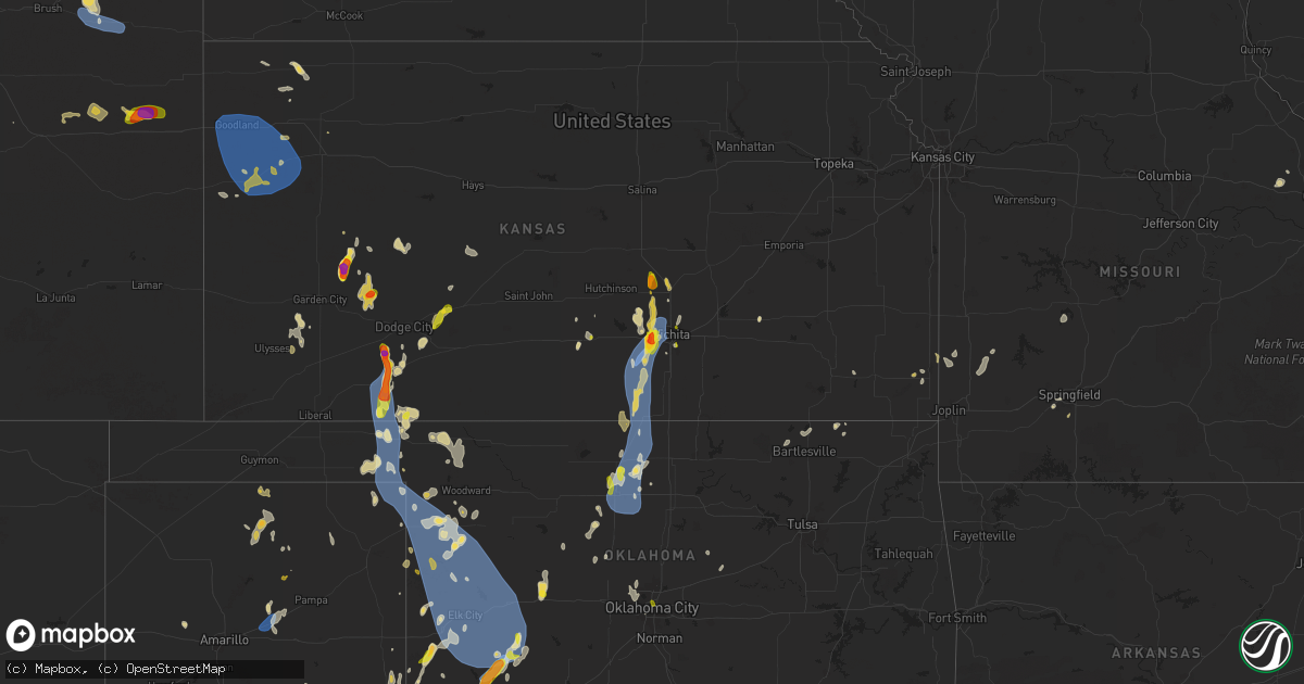
Hail Map on July 8, 2025
Get this storm
July 8 map
$229
one time, instant access
Download today. No call, no setup
Keep the $229
Bought the map and want the full workflow? Apply the entire $229 to a subscription within 7 days. None of it is wasted.
Every map, not just this one
This buys you this map. Subscription and you get every map we run, in the markets you choose from a few cities to whole states to nationwide. Plus real-time alerts the moment a storm fires.
Contact data
Name, contact info, occupancy, even credit band for addresses in the footprint. You go from where it hit to who to call.
Become the source they trust
Unlimited branding weather history reports on demand. You already have the documented answer ready for the property owner, and you are the one who showed up with it.
Property data and RoofTrace estimates
Pull up any address you have got, its value and the exact code rules for that jurisdiction, straight from One Click Code. Then RoofTrace estimates the squares, pitch, and roof value, priced the way you price.
States Impacted by Hail Map on July 8, 2025
Storm reports
Idaho
| Date | Description |
|---|---|
| 07/08/20255:50 PM CDT | Mesonet station pc371 medicine lodge. |
Virginia
| Date | Description |
|---|---|
| 07/08/20256:55 PM CDT | A tree was knocked down along settlers landing rd. |
| 07/08/20256:45 PM CDT | Tree down on rt. 669 in the county of goochland... In the vicinity of hickory hill rd; rt. 609e/w |
| 07/08/20256:43 PM CDT | A tree fell down along jerusalem plank rd. |
| 07/08/20256:36 PM CDT | Trees and powerlines down along the richmond beach rd and east circle dr. |
| 07/08/20256:06 PM CDT | A wind gust of 60 mph was measured by a personal weather station on brittany road. |
| 07/08/20255:28 PM CDT | Thunderstorm winds blew down one tree along the 600 block of beckham road. |
| 07/08/20255:26 PM CDT | Thunderstorm winds blew down one tree near the intersection of stonewall road and vineyard road. |
| 07/08/20255:05 PM CDT | Corrects previous tstm wnd dmg report from 2 se sussex. Tree was knocked down on a house along hines ln. |
| 07/08/20255:03 PM CDT | Tree down at the intersection of dixie airport road and amelon expressway in amherst county virginia. |
| 07/08/20254:57 PM CDT | Tree down at the intersection of winridge drive and wine sap road in amherst county virginia. |
| 07/08/20254:55 PM CDT | A tree fell down along comans well rd. |
| 07/08/20254:52 PM CDT | Tree down at the intersection of ferry road and holcomb rock road in bedford county virginia. |
| 07/08/20253:11 PM CDT | Trees down on wolftown hood road south of hood. |
| 07/08/20253:01 PM CDT | Trees down on hume road. |
| 07/08/20252:14 PM CDT | Tree down on berlin turnpike near lovettsville. |
| 07/08/20252:01 PM CDT | Multiple trees reported down in the town of mount jackson. |
| 07/07/20258:12 PM CDT | Tree was knocked down on a house along hines ln. |
| 07/07/20257:46 PM CDT | Thunderstorm winds blew down a power line near the intersection of glebe road and orchard lake drive. |
| 07/07/20257:43 PM CDT | Thunderstorm winds blew down a power line near the intersection of catawba road and glebe road. |
| 07/07/20257:42 PM CDT | Thunderstorm winds blew down a power line near the intersection of catawba road and etzler road. |
| 07/07/20257:13 PM CDT | Down tree on rt. 637 in the county of goochland... In the vicinity of rt. 698n/s |
| 07/07/20257:06 PM CDT | A tree was knocked down along rock castle rd. |
| 07/07/20257:05 PM CDT | A tree was down along oakland rd. |
| 07/07/20257:05 PM CDT | A tree fell along broad street rd. |
Illinois
| Date | Description |
|---|---|
| 07/08/20254:15 PM CDT | Delayed report. Tree down on a power line. Estimated thunderstorm wind gusts 50 to 60 mph. |
Alabama
| Date | Description |
|---|---|
| 07/08/20252:20 PM CDT | Limestone ema reported several trees down and uprooted along poplar point road. |
Connecticut
| Date | Description |
|---|---|
| 07/08/20251:40 PM CDT | Strong wind gusts associated with thunderstorms resulted in a few downed trees as well as large branches too. |
| 07/08/202512:59 PM CDT | Social media report of multiple downed trees... Including one that damaged an outhouse... Near the white memorial conservation center. Time estimated from radar. |
| 07/08/202512:40 PM CDT | Tree down on wires on cornwall road. |
| 07/08/202512:38 PM CDT | Multiple trees and wires downed on route 7. The roadway was closed to traffic. |
| 07/07/202510:50 PM CDT | Northbound side of i-395 between mile markers 37-38 near killingly had a large tree blocking the right lane. Relayed by amateur radio. |
| 07/07/202510:45 PM CDT | Tree down blocking part of riverside drive in thompson. Relayed by amateur radio. |
Maine
| Date | Description |
|---|---|
| 07/08/202511:08 AM CDT | 12-18 inch diameter tree down on a driveway in biddeford. Time estimated by radar. |
Kentucky
| Date | Description |
|---|---|
| 07/08/20251:20 PM CDT | A few trees down in the city. |
Missouri
| Date | Description |
|---|---|
| 07/08/20252:43 PM CDT | Several trees down across mo 94 between hwy b and u. |
Wisconsin
| Date | Description |
|---|---|
| 07/08/20256:49 PM CDT | Several tree branches down. Report via calumet county sheriff office. |
| 07/08/20255:16 PM CDT | Medium-sized tree splintered at the base and blocking a road. Photo received via social media. Time estimated from radar. |
| 07/08/20254:53 PM CDT | 1 inch hail reported by local business. Time estimated from radar. |
| 07/08/20254:44 PM CDT | Delayed report. Average of largest hail stones from storms late tuesday afternoon. Cocorahs location is suring 2.0 wnw. |
| 07/08/20254:05 PM CDT | Report from mping: quarter |
| 07/08/20253:55 PM CDT | Delayed report. Multiple trees downed in pembine from storms on tuesday afternoon. Via social media. |
| 07/08/20253:41 PM CDT | Trees and power lines down in aurora. |
| 07/08/20253:36 PM CDT | Delayed report. Trees down at aurora cemetery due with storms on tuesday afternoon. Power out in the area. |
| 07/07/20257:47 PM CDT | Dodge county dispatch reports of a fallen tree on horicon st in mayville. Time estimated based on radar. |
Massachusetts
| Date | Description |
|---|---|
| 07/07/202511:25 PM CDT | Tree down on wires in the area of the 200th block of purgatory road in the town of northbridge. |
| 07/07/202511:10 PM CDT | Large tree downed on perry st in douglas. Relayed by amateur radio. |
| 07/07/202511:05 PM CDT | Tree down blocking most of ardlock place near intersection with west main st in dudley. Relayed by amateur radio. |
Rhode Island
| Date | Description |
|---|---|
| 07/07/202511:10 PM CDT | Tree down blocking the roadway in the westbound lane of east avenue in burrillville. Relayed by amateur radio. |
Mississippi
| Date | Description |
|---|---|
| 07/08/20253:38 PM CDT | A tree was reported down off of highway 46. |
Pennsylvania
| Date | Description |
|---|---|
| 07/08/20255:28 PM CDT | Water rescues and roads closed around the lower and upper southampton area. Time estimated. |
| 07/08/20255:10 PM CDT | Trees and wires down. Time estimated from radar. |
| 07/08/20255:07 PM CDT | Trees and wires down in trevose. Time estimated from radar. |
| 07/08/20255:05 PM CDT | Trees and wires down in lower and upper southampton township. Time estimated from radar. |
| 07/08/20254:42 PM CDT | *delayed report* multiple trees snapped and one uprooted with a shed destroyed. Time estimated from radar. |
| 07/08/20254:42 PM CDT | Trees and wires down around whitpain township. Time estimated from radar. |
| 07/08/20254:40 PM CDT | Tree down on i-76 near gulph mills. |
| 07/08/20254:27 PM CDT | Large tree down blocking roadway at the corner of hillcrest ave and evergreen rd. Time estimated from radar. |
| 07/08/20254:27 PM CDT | Trees and wires down near upper merion township... Pa. Time estimated from radar. |
| 07/08/20254:24 PM CDT | Wires down on egypt rd and school ln. Time estimated from radar. |
| 07/08/20254:24 PM CDT | Corrects previous tstm wnd dmg report from west norriton. Trees and wires down throughout west norriton. Time estimated from radar. |
| 07/08/20254:22 PM CDT | Cluster of trees and wires down around lower frederick township... Pa. Time estimated from radar. |
| 07/08/20254:19 PM CDT | Trees and wires down. Time estimated from radar. |
| 07/08/20254:19 PM CDT | Trees down in tredyffrin twp. Time estimated from radar. |
| 07/08/20254:19 PM CDT | Trees and wired down. Time estimated from radar. |
| 07/08/20254:15 PM CDT | Several trees and wires down around pottstown and pottsgrove. Time estimated from radar. |
| 07/08/20254:15 PM CDT | Numerous trees down. Time estimated from radar. |
| 07/08/20254:13 PM CDT | Tree fell on occupied vehicle. No injuries. |
| 07/08/20254:13 PM CDT | Large tree down. Time estimated from radar. |
| 07/08/20254:10 PM CDT | Trees and wires down. Time estimated from radar. |
| 07/08/20254:10 PM CDT | Damage to house shutters... Trees down in pottstown. Time estimated from radar. |
| 07/08/20254:05 PM CDT | Pictures of widespread tree damage in upper uwchlan township sent in by an em. Time estimated from radar. |
| 07/08/20254:05 PM CDT | Numerous trees down. Time estimated from radar. |
| 07/08/20254:03 PM CDT | Trees and wires down. Time estimated from radar. |
| 07/08/20254:02 PM CDT | Measured 68 mph gust in pottstown. Time included in report. |
| 07/08/20254:02 PM CDT | Quarter-size hail in pottstown. Video sent via social media. Time included with report. |
| 07/08/20254:01 PM CDT | Report and photos showing a large tree snapped and a shed completed destroyed by wind at a residence on carriage lane in west vincent twp. Time estimated from radar. |
| 07/08/20253:59 PM CDT | Relayed via social media. Time included with report. |
| 07/08/20253:45 PM CDT | Wires and poles down. Time est. |
| 07/08/20253:43 PM CDT | Picture of large trees down on wires on seyfert drive in birdsboro... Pa. Time estimated from radar. |
| 07/08/20253:38 PM CDT | Tree down on a residence. Time estimated from radar. |
| 07/08/20253:31 PM CDT | Trees down on powerlines causing a fire on bailey crossroads rd. Time estimated from radar. |
| 07/08/20253:26 PM CDT | Picture of large trees down in kenhorst. Time estimated from radar. |
| 07/08/20253:26 PM CDT | Picture of large trees down in shartlesville... Pa. Time estimated from radar. |
| 07/08/20253:21 PM CDT | Reports of storm damage on the 200 block of hopeland road. |
| 07/08/20253:03 PM CDT | Thunderstorm damage reported in west cocalico township. |
| 07/08/20253:00 PM CDT | Tree down on a house on the 300 block of greenville road. No injuries reported. |
| 07/08/20252:56 PM CDT | Tree onto wires. |
| 07/08/20252:52 PM CDT | Tree and wires down on west market street near the intersection of south royal street. |
| 07/08/20252:51 PM CDT | Tree down on the 400 block of south race street. |
| 07/08/20252:49 PM CDT | Thunderstorm damage reported in clay township. |
| 07/08/20251:49 PM CDT | Tree down blocking one lane of creek road near the intersection of lehman road. |
| 07/08/20251:47 PM CDT | Tree down blocking the roadway on clarks valley road. |
| 07/08/202512:58 PM CDT | Tree on wires on 200 block hower rd. |
Arizona
| Date | Description |
|---|---|
| 07/07/20257:54 PM CDT | Report of damage to roofing. Nearby wind gust of 51 mph. |
New Jersey
| Date | Description |
|---|---|
| 07/08/20256:36 PM CDT | Nos site at sandy hook. |
| 07/08/20256:36 PM CDT | Sandy hook nos gauge gusted to 63 mph |
| 07/08/20256:25 PM CDT | Tree into a home. Time estimated from radar. |
| 07/08/20256:25 PM CDT | Trees and wires down. Time estimated from radar. |
| 07/08/20256:16 PM CDT | Trees down on kent road near ford road. Road closed. Time estimated from radar. |
| 07/08/20256:04 PM CDT | Large tree down blocking big oak road. Time estimated from radar. |
| 07/08/20255:43 PM CDT | Multiple large branches downed. |
| 07/08/20255:40 PM CDT | Wires downed. |
| 07/08/20255:38 PM CDT | Numerous trees and wires down. Time estimated from radar. |
| 07/08/20255:30 PM CDT | As of 6:48pm... Theres a downed tree on us 1 southbound north of franklin corner rd/bakers basin rd in lawrence twp. All lanes closed. Time estimated from radar. |
| 07/08/20255:28 PM CDT | As of 7:00pm... Theres a downed tree on i-295 southbound south of exit 52 - columbus rd in florence twp. 1 left lane of 3 lanes closed. Time estimated from radar. |
| 07/08/20255:21 PM CDT | Several tree limbs down. Estimated 60 mph gust. |
| 07/08/20255:20 PM CDT | Trees and powerlines down across rt 1. |
| 07/08/20255:19 PM CDT | 58 mph wind gust occurred at trenton mercer airport. |
| 07/08/20255:17 PM CDT | Trees and lines down throughout ewing. Time estimated from radar. |
| 07/08/20255:15 PM CDT | Wires down. |
| 07/08/20255:15 PM CDT | Wires down. |
| 07/08/20255:15 PM CDT | Numerous trees and wires down... With some roadways blocked. Time estimated from radar. |
| 07/08/20251:26 PM CDT | Trees and wires down at lake shore drive/warwick tpk. |
| 07/08/20251:15 PM CDT | Trees on wires. |
| 07/08/20251:11 PM CDT | Trees on wires across rocky point road. |
| 07/08/20251:07 PM CDT | Tree and wires down. |
| 07/08/202512:42 PM CDT | Tree and wire downed from oem. Time est. |
New York
| Date | Description |
|---|---|
| 07/08/20251:30 PM CDT | Tree down on route 202 near mayer drive. Right lane is closed. Time estimated by radar. |
| 07/08/20251:30 PM CDT | Corrects previous tstm wnd dmg report from 1 nne montebello. Large tree fell onto a truck on kevin drive. The tree also blocked the road and took down power lines. Time |
| 07/08/20251:08 PM CDT | Tree down causing the closure of jersey avenue. |
| 07/08/20251:07 PM CDT | Dot tree down across rte 129. All lanes blocked. |
| 07/08/202512:55 PM CDT | Large tree down on power lines. |
| 07/08/202512:35 PM CDT | Tree down on the exit 16 ramp of the palisades interstate parkway. |
| 07/07/20257:56 PM CDT | Mesonet station xbay bayville. |
Maryland
| Date | Description |
|---|---|
| 07/08/20256:34 PM CDT | 2 trees down near intersection of chingville rd and medleys neck rd |
| 07/08/20255:54 PM CDT | Report of a roof collapse of a building near ridgley. Time estimated from radar. |
| 07/08/20255:48 PM CDT | Several trees and power lines down around the royal oak area. Time estimated by radar. |
| 07/08/20255:45 PM CDT | Several trees and wires down around saint michaels. Time estimated by radar. |
| 07/08/20255:30 PM CDT | Trees and wires down across the roadway at price station rd and cox sawmill rd. Time estimated from radar. |
| 07/08/20255:30 PM CDT | Downed tree on prospect bay dr. W and gold cart dr. Time estimated from radar. |
| 07/08/20255:30 PM CDT | Trees and wires down across the roadway at price station rd and cox sawmill rd. Time estimated from radar. |
| 07/08/20255:30 PM CDT | Trees down around grasonville. Time estimated by radar. |
| 07/08/20255:30 PM CDT | Downed tree on prospect bay dr. W and gold cart dr. Time estimated from radar. |
| 07/08/20255:30 PM CDT | Trees down around grasonville. Time estimated by radar. |
| 07/08/20255:26 PM CDT | Multiple trees reported down in and around cecilton. |
| 07/08/20255:17 PM CDT | Personal weather station kmdchest61 gusted to 70.2 mph. |
| 07/08/20255:17 PM CDT | Personal weather station kmdchest61 gusted to 70.2 mph. |
| 07/08/20255:12 PM CDT | Two trees down on sudley road just west of galesville. |
| 07/08/20255:00 PM CDT | Numerous trees and wires down in the worton area. Time estimated by radar. |
| 07/08/20255:00 PM CDT | Several reports of trees and powerlines down near fairlee. Time estimated. |
| 07/08/20254:58 PM CDT | Two trees reported down on the north side of elkton. |
| 07/08/20254:54 PM CDT | Widespread downed trees and wires around rock hall... Md. Time estimated by radar. |
| 07/08/20254:36 PM CDT | Multiple calls for trees down between aberdeen and havre de grace. |
| 07/08/20254:35 PM CDT | Harford county airport awos gusted to 50 kt / 58 mph. |
| 07/08/20254:31 PM CDT | Multiple calls for trees down in and around churchville. |
| 07/08/20254:18 PM CDT | Multiple calls for trees down in and around bel air. |
| 07/08/20254:18 PM CDT | Several trees snapped on walter's mill road in forest hill. |
| 07/08/20254:13 PM CDT | Two trees on a house in white marsh. |
| 07/08/20254:02 PM CDT | Wind gust to 77 mph measured at patuxent naval air station asos. |
| 07/08/20253:56 PM CDT | Multiple reports of trees down in columbia. |
| 07/08/20253:56 PM CDT | Multiple reports of trees down in lexington park. |
| 07/08/20253:56 PM CDT | Multiple reports of trees down in laurel. |
| 07/08/20253:47 PM CDT | Multiple reports of trees down in callaway. |
| 07/08/20252:26 PM CDT | Two trees reported down near point of rocks off ballenger creek pike. |
| 07/07/20258:26 PM CDT | *** 1 inj *** severe winds damaged crops and downed trees near pocomoke city. An ems vehicle was almost overturned in high wind and a motorcyclist was blown off the hig |
| 07/07/20258:18 PM CDT | *** 1 inj *** corrects previous tstm wnd dmg report from 2 wnw pocomoke city. Corrects previous tstm wnd dmg report from 2 wnw pocomoke city. Severe winds damaged crops |
| 07/07/20258:18 PM CDT | *** 1 inj *** corrects previous tstm wnd dmg report from 2 wnw pocomoke city. Severe winds damaged crops and downed trees near pocomoke city. An ems vehicle was almost |
| 07/07/20257:45 PM CDT | A tree fell down along maiden forest rd. |
Oklahoma
| Date | Description |
|---|---|
| 07/08/20254:33 PM CDT | Report from mping: quarter |
| 07/07/202511:48 PM CDT | Kcsm. |
| 07/07/202511:33 PM CDT | A local report indicates 58 MPH wind near 3 NE Clinton |
| 07/07/202511:19 PM CDT | A local report indicates 58 MPH wind near 1 NE Elk City |
| 07/07/202511:17 PM CDT | A local report indicates 68 MPH wind near 3 S Sayre |
| 07/07/202511:05 PM CDT | A local report indicates 58 MPH wind near 8 WSW Arnett |
| 07/07/202510:35 PM CDT | A local report indicates 59 MPH wind near 4 WNW Camargo |
| 07/07/202510:30 PM CDT | A crane was blown over onto a truck. |
| 07/07/202510:19 PM CDT | A local report indicates 71 MPH wind near 3 SE Frederick |
| 07/07/202510:00 PM CDT | Arnett mesonet. |
| 07/07/202510:00 PM CDT | Arnett mesone |
| 07/07/20259:00 PM CDT | 58 mph at 9pm. 59 is the peak so far and still another 59 mph gust at 915. |
| 07/07/20258:48 PM CDT | Report from mping: ping pong ball |
| 07/07/20258:44 PM CDT | A local report indicates 1.00 inch wind near 2 S Hobart |
| 07/07/20258:40 PM CDT | Hobart mesonet. |
| 07/07/20258:38 PM CDT | Em relayed 2nd hand information on 4-5 inch tree limbs down as well as corn stalks blown completely over. They estimated up to 60 mph winds with this damage. |
| 07/07/20258:38 PM CDT | Farmer reported hail on both sides of knowles. West side had pea sized up to nickel. East side had hail up to quarters. And it hailed about 5 minutes. |
| 07/07/20258:34 PM CDT | A local report indicates 69 MPH wind near 3 SE Hobart |
| 07/07/20258:14 PM CDT | A local report indicates 1.00 inch wind near 1 W Enid |
| 07/07/20257:55 PM CDT | Light roof damage to a manufactured home along with a power pole blown down. Handheld anemometer recorded a 71-mph wind gust. Time estimated from radar. |
| 07/07/20257:54 PM CDT | A local report indicates 1.25 inch wind near Kremlin |
| 07/07/20257:46 PM CDT | A local report indicates 70 MPH wind near Kremlin |
| 07/07/20257:30 PM CDT | A local report indicates 61 MPH wind near 1 SW Medford |
| 07/07/20257:18 PM CDT | A local report indicates 63 MPH wind near 3 W Deer Creek |
Texas
| Date | Description |
|---|---|
| 07/08/20255:30 PM CDT | Social media post of downed powerlines at ft. Bliss. Time approximated based on top gust at kbif. |
| 07/08/20252:07 AM CDT | Trees... Power lines down i |
| 07/08/20252:07 AM CDT | Per west texas mesonet 3 miles southwest of snyder. |
| 07/08/20252:07 AM CDT | Trees... Power lines down in snyder. A few roofs blown off. |
| 07/08/20252:07 AM CDT | Per west texas mesonet 3 miles east of snyder. |
| 07/08/20252:07 AM CDT | Trees... P |
| 07/08/20252:07 AM CDT | Trees... Power li |
| 07/08/202512:54 AM CDT | A local report indicates 60 MPH wind near 1 SSW Panhandle |
| 07/07/202511:51 PM CDT | A local report indicates 59 MPH wind near 3 N Avoca |
| 07/07/202511:45 PM CDT | A local report indicates 71 MPH wind near 3 NW Seymour |
| 07/07/202511:40 PM CDT | A local report indicates 71 MPH wind near 3 NW Seymour |
| 07/07/202511:35 PM CDT | A local report indicates 71 MPH wind near 3 NW Seymour |
| 07/07/202511:30 PM CDT | Corrects previous tstm wnd gst report from 3 nw seymour. |
| 07/07/202511:30 PM CDT | A local report indicates 71 MPH wind near 3 NW Seymour |
| 07/07/202511:24 PM CDT | A local report indicates 64 MPH wind near 3 NW Seymour |
| 07/07/202511:23 PM CDT | A local report indicates 67 MPH wind near 1 NW Haskell |
| 07/07/202511:10 PM CDT | A local report indicates 59 MPH wind near 1 E Crowell |
| 07/07/202511:03 PM CDT | A local report indicates 62 MPH wind near 2 NNE Weinert |
| 07/07/202511:00 PM CDT | A local report indicates 59 MPH wind near 1 E Crowell |
| 07/07/202510:40 PM CDT | A local report indicates 60 MPH wind near 3 NW Knox City |
| 07/07/202510:35 PM CDT | A local report indicates 60 MPH wind near 3 NW Knox City |
| 07/07/202510:32 PM CDT | Corrects previous tstm wnd gst report from 3 nw knox city. |
| 07/07/202510:15 PM CDT | Kmkn awos. |
| 07/07/202510:00 PM CDT | A local report indicates 81 MPH wind near 1 E Crowell |
| 07/07/20259:57 PM CDT | Half of roof removed at crowell high school. Time estimated by wind gusts at nearby wtm site. |
| 07/07/20259:55 PM CDT | A local report indicates 81 MPH wind near 1 E Crowell |
| 07/07/20259:35 PM CDT | A local report indicates 68 MPH wind near Comanche Springs |
| 07/07/20259:32 PM CDT | Corrects previous tstm wnd gst report from comanche springs. |
| 07/07/20259:31 PM CDT | A local report indicates 59 MPH wind near 8 WSW Lipscomb |
| 07/07/20258:55 PM CDT | Goodlett awos. |
| 07/07/20258:50 PM CDT | Goodlett awos. |
| 07/07/20258:44 PM CDT | Corrects previous tstm wnd gst report from 3 w goodlett. |
| 07/07/20258:15 PM CDT | Social media photo of tree damage near mayfield and collins street in arlington. Several branches of 4 inch diameter snapped. Time estimated. |
| 07/07/20258:03 PM CDT | Tree blown over onto a home. Time estimated. |
| 07/07/20257:53 PM CDT | Ground reported to be covered with hail. |
| 07/07/20257:53 PM CDT | Ground reporte |
| 07/07/20257:31 PM CDT | A local report indicates 61 MPH wind near 6 SE Wellington |
| 07/07/20257:20 PM CDT | Hail estimated to be half dollar. Numerous tree limbs down due to wind. Hail was more destructive about a mile to his southeast where a cotton field was completely dest |
Kansas
| Date | Description |
|---|---|
| 07/08/20256:46 PM CDT | Estimated 60-70 mph. |
| 07/08/20256:44 PM CDT | A local report indicates 1.00 inch wind near 1 NW Kingman |
| 07/08/20256:15 PM CDT | Pictures of 1 inch hail via social media. |
| 07/08/20256:10 PM CDT | Pictures of 1 inch hail via social media. |
| 07/08/20256:05 PM CDT | Reported from ksu mesonet site. |
| 07/08/20255:55 PM CDT | 4 diameter limb down. |
| 07/08/20255:55 PM CDT | 4 inch diameter limb down. |
| 07/08/20255:54 PM CDT | Kansas mesonet sens |
| 07/08/20255:54 PM CDT | Kansas mesonet sensor measured a peak of 64 mph. |
| 07/08/20255:54 PM CDT | Reported wind along with half inch sized hail. |
| 07/08/20255:53 PM CDT | A local report indicates 1.00 inch wind near 1 WSW Offerle |
| 07/08/20255:50 PM CDT | A local report indicates 2.00 inch wind near 2 SW Kalvesta |
| 07/08/20255:48 PM CDT | Several limbs down... Estimated 65-70 mph. |
| 07/08/20255:42 PM CDT | A local report indicates 1.00 inch wind near 5 WSW Kalvesta |
| 07/08/20255:35 PM CDT | Report received via social media. |
| 07/08/20255:34 PM CDT | Report from mping. |
| 07/08/20255:33 PM CDT | Report from mping. |
| 07/08/20255:32 PM CDT | Public report via social media with photo. |
| 07/08/20255:30 PM CDT | Picture received via social media of 1-foot diameter cottonwood tree blown over. |
| 07/08/20255:30 PM CDT | Report received via |
| 07/08/20255:30 PM CDT | Report received via social media. |
| 07/08/20255:29 PM CDT | A local report indicates 1.00 inch wind near 1 SSE Bel Aire |
| 07/08/20254:20 PM CDT | A local report indicates 1.50 inch wind near 5 S Moundridge |
| 07/07/202510:31 PM CDT | Mesonet station up840 |
| 07/07/202510:31 PM CDT | Mesonet station up840 9.0 w winona |
| 07/07/20258:40 PM CDT | Multiple 2 inch stones i |
| 07/07/20258:40 PM CDT | Multiple 2 inch stones in a picture via social media. |
| 07/07/20258:15 PM CDT | A local report indicates 1.00 inch wind near 1 E Englewood |
| 07/07/20257:36 PM CDT | Picture via social media of 1 inch hail. |
| 07/07/20257:34 PM CDT | Upr meade recorded a 60 mph wind gust at 7:34 cdt. |
| 07/07/20257:05 PM CDT | Follow-up on a previous report with more details. Most hail was golf ball to 2-inch diameter... But largest tennis ball size. Two vehicles suffered windshield damage... |
| 07/07/20257:04 PM CDT | A local report indicates 2.00 inch wind near 7 SSE Ensign |
| 07/07/20257:00 PM CDT | A local report indicates 1.75 inch wind near 7 S Ensign |
New Mexico
| Date | Description |
|---|---|
| 07/08/20256:55 PM CDT | Mesonet station wsm28 wsmr tula. |
| 07/08/20256:55 PM CDT | Awos station k4mr tolar 12 se. |
| 07/08/20256:39 PM CDT | Mesonet station bchn5 carrizozo 15 nw |
| 07/08/20256:30 PM CDT | Mesonet station wsm25 wsmr rita. |
| 07/08/20256:15 PM CDT | Mesonet station wsm06 pole 616 |
| 07/08/20256:15 PM CDT | Mesonet station wsm30 phillips hill |
| 07/08/20256:05 PM CDT | Mesonet station wsm43 little burro |
| 07/08/20256:00 PM CDT | Mesonet station wsm44 tower 6 |
Colorado
| Date | Description |
|---|---|
| 07/08/20256:00 PM CDT | Truck overturned along i-70 |
| 07/08/20256:00 PM CDT | Truck overturned along i-70 possibly due to strong wind gusts from a nearby thunderstorm. |
| 07/08/20256:00 PM CDT | Truck overturned along i-70 possibly due to strong wind gusts from a nearby thunder |
| 07/08/20254:35 PM CDT | Social media report of multiple tree branches down in globeville. Time estimated. |
| 07/08/20254:28 PM CDT | Report via social media. Measured a 50 mph gust using a handheld anemometer. A few trees down along with numerous 1-3 inch diameter branches. |
| 07/07/20259:45 PM CDT | Mesonet station tt563 south republican. |
| 07/07/20259:35 PM CDT | Corrects previous tstm wnd dmg report from 7 ene heartstrong. Relayed report. Report of a damaged outbuilding with pictures that may be related to storm winds. Time was |
| 07/07/20258:18 PM CDT | Relayed report. Report of a damaged outbuilding with pictures that may be related to storm winds. Time estimated from radar. Damage found at 840pm mt. |
| 07/07/20257:10 PM CDT | Awos station kako akron. |
| 07/07/20257:07 PM CDT | Mesonet station ew7755 akron. |
Delaware
| Date | Description |
|---|---|
| 07/08/20256:25 PM CDT | One or two trees downed. Time est by radar. |
| 07/08/20255:44 PM CDT | Tree damage reported on beaver dam rd. Near laurel. Time estimated from radar. |
North Carolina
| Date | Description |
|---|---|
| 07/08/20255:50 PM CDT | Trees down on power equipment. |
| 07/08/20255:50 PM CDT | Trees down on power equipment. |
| 07/08/20255:21 PM CDT | Trees down on power equipment. |
| 07/08/20255:21 PM CDT | Trees down on power equipment. |
| 07/08/20255:05 PM CDT | Tree reported down on powerlines at 1733 sapona rd. At 609 pm... Estimated by radar to have occurred at 605 pm. |
| 07/08/20255:05 PM CDT | Tree reported down at 1733 sapona rd. At 609 pm... Estimated by radar to have occurred at 605 pm. |
| 07/08/20255:05 PM CDT | Corrects previous tstm wnd dmg report from 3 w vander. Tree reported down on powerlines at 1733 sapona rd. At 609 pm... Estimated by radar to have occurred at 605 pm. |
| 07/08/20255:00 PM CDT | Corrects previous tstm wnd dmg report from 3 n hope mills. Trees reported down on pala verde dr. At 608 pm... Estimated from radar to have occurred at 600 pm. |
| 07/08/20255:00 PM CDT | Trees reported down on pala verde dr. At 608 pm... Estimated from radar to have occurred at 600 pm. |
| 07/08/20255:00 PM CDT | Tree reported down on pala verde dr. At 608 pm... Estimated from radar to have occurred at 600 pm. |
| 07/08/20254:45 PM CDT | Tree fell on a house at 7146 us 401 s. |
| 07/08/20254:35 PM CDT | Tree reported down on mt. Olive church rd. At 539 pm... Estimated from radar to have occurred at 535 pm. |
| 07/08/20254:32 PM CDT | Tree reported down at 3117 norrington rd at 538 pm... Estimated from radar to have occurred at 532 pm. |
| 07/07/20257:39 PM CDT | Thunderstorm winds blew down one tree that fell on to a power pole along the 300 block of manley farm road. |
| 07/07/20257:29 PM CDT | Thunderstorm winds blew down one tree on kenwick court. |
| 07/07/20257:21 PM CDT | Thunderstorm winds blew down one tree that fell on to a power line along the 2200 block of south scales street. |
Michigan
| Date | Description |
|---|---|
| 07/08/20255:10 PM CDT | A local business reports hail the size of quarters in wallace... Mi. |
| 07/08/20255:00 PM CDT | Menominee county 911 reports multiple trees down in the area of g-08 and county roads 577 and 581. |
| 07/08/20252:41 PM CDT | Social media report of trees uprooted due to thunderstorm winds in alpha. Time estimated using radar. |
| 07/08/20252:41 PM CDT | Social media report of quarter size hail in alpha. Time estimated from radar. |
Cities Impacted by Hail Map on July 8, 2025
- Montreal, MO
- Stoutland, MO
- Warwick, NY
- Millbrook, NY
- Moncks Corner, SC
- Ridgeville, SC
- Summerville, SC
- Cottage Grove, TN
- Palmersville, TN
- Monroe, NY
- Tuxedo Park, NY
- Puryear, TN
- Wassaic, NY
- Sharon, CT
- Amenia, NY
- Southfields, NY
- Sussex, NJ
- Cadiz, KY
- Kent, CT
- Stony Point, NY
- Dover Plains, NY
- Branchville, NJ
- Cornwall Bridge, CT
- Bonneau, SC
- Saint Stephen, SC
- Hamburg, NJ
- Vernon, NJ
- Thiells, NY
- Garnerville, NY
- West Haverstraw, NY
- Tomkins Cove, NY
- Pomona, NY
- Pangburn, AR
- Litchfield, CT
- Harwinton, CT
- Northfield, CT
- Iron River, MI
- Cushing, OK
- Croton On Hudson, NY
- Bantam, CT
- Montrose, NY
- Haverstraw, NY
- Ossining, NY
- Keysville, GA
- Hopkinsville, KY
- Warrenton, MO
- Trout Creek, MI
- Sterling Forest, NY
- Ladson, SC
- Chandler, OK
- Stroud, OK
- Crescent, OK
- Harrisburg, PA
- Annville, PA
- Grantville, PA
- Arkadelphia, AR
- Dauphin, PA
- Hartsville, SC
- Lynchburg, SC
- Orangeburg, SC
- Saint Matthews, SC
- Waynesboro, GA
- Perkins, OK
- Tryon, OK
- California, MO
- Jamestown, MO
- Tower City, PA
- Stockton, MO
- Crystal Falls, MI
- Eastover, SC
- Timmonsville, SC
- Twin City, GA
- Swainsboro, GA
- Blenheim, SC
- Cameron, SC
- Troy, MO
- Hawk Point, MO
- Williamsville, IL
- Riverton, IL
- Broken Bow, OK
- Wright City, OK
- Pittsburg, MO
- Wheatland, MO
- Flemington, MO
- Gurdon, AR
- Lititz, PA
- Manheim, PA
- Paducah, TX
- Marthasville, MO
- Corona, NM
- Alpha, MI
- Bolivar, MO
- Polk, MO
- Mechanicsburg, PA
- Lewisberry, PA
- Vaughn, NM
- Old Monroe, MO
- Moscow Mills, MO
- Sparkman, AR
- Ephrata, PA
- Stevens, PA
- Rhine, GA
- Milan, GA
- Darlington, SC
- O'Fallon, MO
- Carthage, AR
- Myerstown, PA
- Richland, PA
- Florence, SC
- Newmanstown, PA
- Lebanon, PA
- Bethel, PA
- Rehrersburg, PA
- Womelsdorf, PA
- Society Hill, SC
- Miami, FL
- Akron, PA
- Leola, PA
- New Holland, PA
- East Earl, PA
- Terre Hill, PA
- Denver, PA
- Gordonville, PA
- Narvon, PA
- Honey Brook, PA
- Morgantown, PA
- Niagara, WI
- Dunbar, WI
- Glenmoore, PA
- Elverson, PA
- Pembine, WI
- The Plains, VA
- Middleburg, VA
- Dillon, SC
- Hamer, SC
- Marion, SC
- Latta, SC
- Sherman, IL
- Mohnton, PA
- Downingtown, PA
- Birdsboro, PA
- Chester Springs, PA
- Stanardsville, VA
- Snow, OK
- Golden Eagle, IL
- Brussels, IL
- White Sands Missile Range, NM
- Westmoreland, TN
- Lake View, SC
- Florence, WI
- Bernville, PA
- Dickens, TX
- Buffalo, IL
- Encino, NM
- Sykesville, MD
- Las Cruces, NM
- Exton, PA
- Pottstown, PA
- Malvern, PA
- Phoenixville, PA
- Amberg, WI
- Daggett, MI
- Wayne, PA
- King Of Prussia, PA
- Oaks, PA
- Norristown, PA
- Douglassville, PA
- Upperville, VA
- Marshall, VA
- Rattan, OK
- Lumber City, GA
- Decatur, AL
- Conshohocken, PA
- Berwyn, PA
- Devon, PA
- Villanova, PA
- Newtown Square, PA
- Bridgeport, PA
- Plymouth Meeting, PA
- Moundridge, KS
- Hesston, KS
- Halstead, KS
- Burrton, KS
- Newton, KS
- Kirkwood, PA
- Fargo, OK
- Genoa, CO
- Franklin, KY
- Milford, CT
- Organ, NM
- Spur, TX
- Bryn Mawr, PA
- Gladwyne, PA
- Lafayette Hill, PA
- Philadelphia, PA
- Haverford, PA
- Ardmore, PA
- Narberth, PA
- Wynnewood, PA
- Merion Station, PA
- Bala Cynwyd, PA
- Oklahoma City, OK
- Lexington Park, MD
- Patuxent River, MD
- Havertown, PA
- Glenside, PA
- Elkins Park, PA
- Wyncote, PA
- Portland, TN
- Quarryville, PA
- Christiana, PA
- Atglen, PA
- Cochranville, PA
- Boyertown, PA
- Reading, PA
- Jenkintown, PA
- Cheltenham, PA
- Huntingdon Valley, PA
- Pawnee, IL
- Glenwood, GA
- Cameron, NC
- Broadway, NC
- Sanford, NC
- Lillington, NC
- Spring Lake, NC
- Bunnlevel, NC
- Red Springs, NC
- Pembroke, NC
- Arriba, CO
- Mount Vernon, GA
- Spring City, PA
- Cloudcroft, NM
- Bensalem, PA
- Hill City, SD
- Hartsburg, IL
- Flagler, CO
- Caspian, MI
- Gaastra, MI
- Linden, NC
- Gilbertsville, PA
- Royersford, PA
- Schwenksville, PA
- Coatesville, PA
- Parkesburg, PA
- Vona, CO
- Seibert, CO
- Stratton, CO
- Uvalda, GA
- Ailey, GA
- Burdett, KS
- North Newton, KS
- Las Vegas, NM
- Limon, CO
- Pecos, NM
- Goddard, KS
- Wichita, KS
- Drummond, OK
- Rush Center, KS
- Rozel, KS
- Nekoma, KS
- Lamar, MO
- Golden City, MO
- Brookline, MO
- Springfield, MO
- Republic, MO
- Nixa, MO
- Clarksdale, MS
- Coalgate, OK
- Kingfisher, OK
- Lane, OK
- Stringtown, OK
- Atoka, OK
- Clearwater, KS
- Duncan, MS
- Alligator, MS
- Okeechobee, FL
- Wausaukee, WI
- Wallace, MI
- Cimarron, KS
- Pylesville, MD
- Street, MD
- Offerle, KS
- Plains, TX
- Whiteford, MD
- Sedgwick, KS
- Larned, KS
- Pittsburg, OK
- Olar, SC
- Fallston, MD
- Baldwin, MD
- Forest Hill, MD
- Jarrettsville, MD
- Thorndale, PA
- Viola, KS
- Mcconnell Afb, KS
- Laverne, OK
- Darlington, MD
- Post, TX
- Ashdown, AR
- Mount Hope, KS
- New Berlin, IL
- Pleasant Plains, IL
- Colwich, KS
- Maize, KS
- Valley Center, KS
- Eureka, KS
- Andale, KS
- Garden Plain, KS
- Phoenix, MD
- Monkton, MD
- Spearville, KS
- Bentley, KS
- Derby, KS
- Hanover, NM
- Bamberg, SC
- Denmark, SC
- Ingalls, KS
- Shattuck, OK
- Fayetteville, NC
- Denver City, TX
- Kechi, KS
- Mayfield, KS
- Conway Springs, KS
- Argonia, KS
- Milton, KS
- Cheney, KS
- Wellington, KS
- Milan, KS
- Caldwell, KS
- Joppa, MD
- Mulberry, KS
- Gage, OK
- Erwin, NC
- Enid, OK
- Rosedale, MD
- Middle River, MD
- Parkville, MD
- Perry Hall, MD
- Nottingham, MD
- Kingsville, MD
- White Marsh, MD
- Clever, MO
- Weatherford, OK
- Geary, OK
- Bethune, CO
- Mindenmines, MO
- Liberal, MO
- Bel Air, MD
- Churchville, MD
- Abingdon, MD
- Essex, MD
- Upper Falls, MD
- Pittsburg, KS
- Frontenac, KS
- Ensign, KS
- Fowler, KS
- Dodge City, KS
- Minneola, KS
- Waukomis, OK
- Jasper, MO
- Bonham, TX
- Telephone, TX
- Dodd City, TX
- Aberdeen, MD
- Glen Arm, MD
- Lockesburg, AR
- Ford, KS
- Murdock, KS
- Cope, SC
- Ivanhoe, TX
- Dunn, NC
- Dundalk, MD
- Pope, MS
- Oakland, MS
- Medford, OK
- Deer Creek, OK
- Hunter, OK
- Lamont, OK
- Pond Creek, OK
- Haven, KS
- Hennessey, OK
- Stephenson, MI
- Honey Grove, TX
- Suring, WI
- Keshena, WI
- Ames, OK
- Sardis, MS
- Cisco, TX
- Gunpowder, MD
- Sparrows Point, MD
- Akron, CO
- Otis, CO
- Yuma, CO
- Gillett, WI
- Odonnell, TX
- Tahoka, TX
- Havre De Grace, MD
- Baltimore, MD
- Edgewood, MD
- Perkiomenville, PA
- Kremlin, OK
- Fairmont, OK
- Garber, OK
- Douglas, OK
- Bison, OK
- McCune, KS
- Cherokee, KS
- Plymouth, MA
- Jetmore, KS
- Kingman, KS
- Brooklet, GA
- Rock Hall, MD
- Meade, KS
- Englewood, KS
- Gate, OK
- Pound, WI
- Mountain, WI
- Brownfield, TX
- Chestertown, MD
- Yale, VA
- Forgan, OK
- Follett, TX
- Chester, MD
- Warwick, RI
- Lamesa, TX
- Barrington, RI
- Warren, RI
- Bristol, RI
- Stevensville, MD
- Cordell, OK
- Gotebo, OK
- Oronogo, MO
- Porterfield, WI
- Sumner, TX
- Grasonville, MD
- Annapolis, MD
- Hobart, OK
- Lone Wolf, OK
- Roosevelt, OK
- Bluff City, KS
- Watonga, OK
- Girard, KS
- Ingalls, MI
- Weir, KS
- Petty, TX
- Saint Michaels, MD
- Bozman, MD
- Mcdaniel, MD
- Wittman, MD
- Claiborne, MD
- Blair, OK
- Altus, OK
- Booker, TX
- Roanoke, VA
- Dighton, KS
- Pattonville, TX
- Magnolia, AR
- Rosston, OK
- Paris, TX
- Prince Frederick, MD
- Asbury, MO
- Menominee, MI
- Easton, MD
- Royal Oak, MD
- Sherwood, MD
- Childress, TX
- Quanah, TX
- Chillicothe, TX
- Crowell, TX
- Salem, VA
- Macon, GA
- Cotulla, TX
- Neavitt, MD
- Courtland, MS
- Centreville, MD
- Seymour, TX
- Cream Ridge, NJ
- Joint Base Mdl, NJ
- Wrightstown, NJ
- Cookstown, NJ
- Salem, NJ
- Roswell, NM
- Ness City, KS
- Clyo, GA
- Jerico Springs, MO
- Tilghman, MD
- Shamrock, TX
- Estill, SC
- Garnett, SC
- Pineland, SC
- Healy, KS
- Allentown, NJ
- New Egypt, NJ
- Chesapeake Beach, MD
- Huntingtown, MD
- Luray, SC
- Queen Anne, MD
- Thomas, OK
- Frederick, OK
- Hollister, OK
- Harrold, TX
- Oklaunion, TX
- Davidson, OK
- Tatum, NM
- Garden City, KS
- Peck, KS
- Cunningham, KS
- Haysville, KS
- Wellington, TX
- Fall River, MA
- Tappahannock, VA
- Vernon, TX
- Benjamin, TX
- Willow, OK
- Turon, KS
- Pembroke, GA
- Gail, TX
- Waverly, VA
- Stony Creek, VA
- Oxford, MD
- Cambridge, MD
- Idalia, CO
- Burlington, CO
- Goodland, KS
- Wray, CO
- Saint Francis, KS
- Kanorado, KS
- Sharon Springs, KS
- Wallace, KS
- Levant, KS
- Edson, KS
- Winona, KS
- Colby, KS
- Brewster, KS
- Monument, KS
- Brunson, SC
- Abrams, WI
- Brillion, WI
- Frankford, DE
- Sussex, VA
- S Coffeyville, OK
- San Jose, NM
- Brussels, WI
- Casco, WI
- Luxemburg, WI
- Beeler, KS
- Varnville, SC
- Dagsboro, DE
- Millsboro, DE
- Hydro, OK
- Queenstown, MD
- Dunnsville, VA
- Munday, TX
- Knox City, TX
- Corn, OK
- Colony, OK
- Ashland, KS
- Lenapah, OK
- Electra, TX
- O'Brien, TX
- Rochester, TX
- Haskell, TX
- Weinert, TX
- Sayre, OK
- Elk City, OK
- Canute, OK
- Sterling, CO
- Church Creek, MD
- Hollis, OK
- Delaware, OK
- South Kent, CT
- Buffalo, OK
- Kaukauna, WI
- Greenleaf, WI
- Forest Junction, WI
- Swansea, MA
- Copan, OK
- Butler, OK
- Clinton, OK
- Foss, OK
- Leedey, OK
- Custer City, OK
- Taloga, OK
- Arapaho, OK
- Camargo, OK
- Sharon, OK
- Arnett, OK
- Vici, OK
- Higgins, TX
- Durham, OK
- Reydon, OK
- Hammon, OK
- Cheyenne, OK
- Crawford, OK
- Carter, OK
- Naples, FL
- Tallulah, LA
- Booneville, MS
- Levelland, TX
- Mayville, WI
- Skellytown, TX
- Dodson, TX
- Beaver, OK
- Stamford, TX
- Rule, TX
- Lueders, TX
- Abilene, TX
- Avoca, TX
- Albany, TX
- Throckmorton, TX
- Goree, TX
- Newcastle, TX
- Olney, TX
- Woodson, TX
- Dill City, OK
- Sentinel, OK
- Bessie, OK
- Granite, OK
- Rocky, OK
- Mountain View, OK
- Florence, AL
- Iron City, TN
- Spearman, TX
- Borger, TX
- Liberal, KS
- Balko, OK
- Courtland, VA
- Jetersville, VA
- Morse, TX
- Windom, TX
- Ellabell, GA
- McKenney, VA
- Crosbyton, TX
- Atwood, KS
- Thayer, KS
- Cashion, OK
- Coila, MS
- Panhandle, TX
- White Deer, TX
- Selbyville, DE
- Bishopville, MD
- Corsicana, TX
- Edmond, OK
- Weskan, KS
- Piedmont, OK
- Gruver, TX
- Bartlesville, OK
- Canadian, TX
- Nicholls, GA
- Fishing Creek, MD
- Yukon, OK
- Fort Stewart, GA
- Oakley, KS
- Desdemona, TX
- Dublin, TX
- Stephenville, TX
- Breckenridge, TX
- Comanche, TX
- Snyder, TX
- Hermleigh, TX
- Ira, TX
- Big Spring, TX
- Colorado City, TX
- Coahoma, TX
- Westbrook, TX
- Stinnett, TX
- Rexford, KS
- Hoxie, KS
- De Leon, TX
- Gorman, TX
- Erick, OK
- Sweetwater, OK
- McDonald, KS
- Miami, TX
- Grand Prairie, TX
- Groom, TX
- Mangum, OK
- Dallas, TX
- Arlington, TX
- Burlington, ND
- Gould, OK
- Eldorado, OK
- Nenzel, NE
- Kilgore, NE
- Satanta, KS
- Ulysses, KS
- Elmer, OK
- Glen Rose, TX
- Sawyer, ND
- Irving, TX
- Vinson, OK
- Tulia, TX
- Bluff Dale, TX
- Velva, ND
- Minot, ND
- Kress, TX
- New Canton, VA
- Norwich, ND
- Millen, GA
- Allen, TX
- Caddo Mills, TX
- Cedar Hill, TX
- Kyle, SD
- Voltaire, ND
- Fort Worth, TX
- Hurst, TX
- Haltom City, TX
- Mountain Park, OK
- Granville, ND
- Quitaque, TX
- Turkey, TX
- Rotan, TX
- Snyder, OK
- Richmond, VA
- Deering, ND
- Bantry, ND
- Glenburn, ND
- Upham, ND
- Martin, SD
- Tuthill, SD
- Newburg, ND
- Lancaster, TX
- Maxbass, ND
- Saint Francis, SD
- Desoto, TX
- Balfour, ND
- Cody, NE
- Bedford, TX
- Tolar, TX
- North Richland Hills, TX
- Crookston, NE
- Valentine, NE