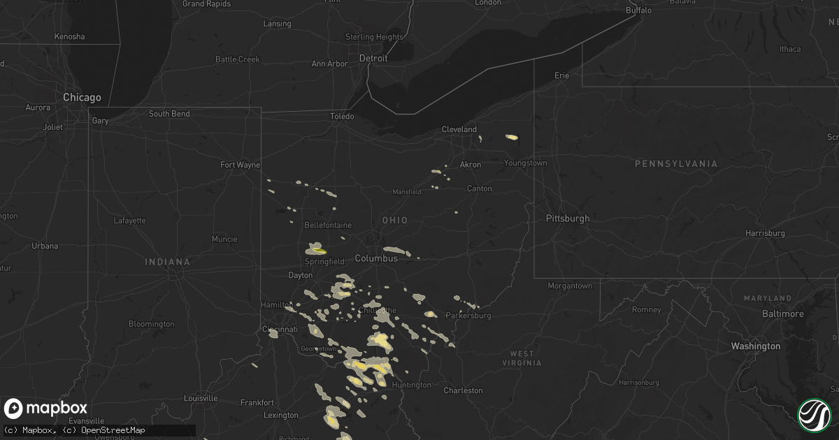
Hail Map in Ohio on July 14, 2015
Get this storm
July 14 map
$229
one time, instant access
Download today. No call, no setup
Keep the $229
Bought the map and want the full workflow? Apply the entire $229 to a subscription within 7 days. None of it is wasted.
Every map, not just this one
This buys you this map. Subscription and you get every map we run, in the markets you choose from a few cities to whole states to nationwide. Plus real-time alerts the moment a storm fires.
Contact data
Name, contact info, occupancy, even credit band for addresses in the footprint. You go from where it hit to who to call.
Become the source they trust
Unlimited branding weather history reports on demand. You already have the documented answer ready for the property owner, and you are the one who showed up with it.
Property data and RoofTrace estimates
Pull up any address you have got, its value and the exact code rules for that jurisdiction, straight from One Click Code. Then RoofTrace estimates the squares, pitch, and roof value, priced the way you price.
Storm reports in Ohio
Ohio
| Date | Description |
|---|---|
| 07/14/20154:50 PM CDT | Numerous branches down... Some larger then 2 dia. And minor damage reported |
| 07/14/20154:09 PM CDT | Numerous trees and tree limbs down across manchester. Power poles snapped. Time estimated by radar. |
| 07/14/20154:08 PM CDT | Tree downed on state route 125. |
| 07/14/20154:06 PM CDT | Tree downed on state route 139 near rubyville. |
| 07/14/20154:06 PM CDT | Trees down along township rd. 150 |
| 07/14/20154:05 PM CDT | Tree downed on state route 73 in rush township. |
| 07/14/20154:04 PM CDT | Tree down on a houe on careys run road. |
| 07/14/20153:55 PM CDT | Tree down on myrtle ave |
| 07/14/20153:55 PM CDT | Large tree down across robinette rd. Time estimated by radar. |
| 07/14/20153:54 PM CDT | Trees down across mitchell rd. |
| 07/14/20153:50 PM CDT | Power lines and poles down |
| 07/14/20153:48 PM CDT | Tree down on house |
| 07/14/20153:42 PM CDT | Trees down |
| 07/14/20153:40 PM CDT | Trees down |
| 07/14/20153:35 PM CDT | Tree downed on state route 335 near stockdale. |
| 07/14/20153:34 PM CDT | Structural damage to garage. |
| 07/14/20153:32 PM CDT | Numerous trees down across pike county... Including several on red hollow rd. Time estimated by radar. |
| 07/14/20153:32 PM CDT | Multiple trees snapped and uprooted...minor siding damage and slate roof shingles blown off a house. |
| 07/14/20153:32 PM CDT | Trees downed on piketon road near fallen timber road. |
| 07/14/20153:30 PM CDT | Porch blown off structure. |
| 07/14/20153:30 PM CDT | Nws storm survey confirms straight line wind damage estimated 75-85 mph. Numerous trees...a few over 8 inches in diameter...were snapped from timberline drive to sherry |
| 07/14/20153:30 PM CDT | Tree down on barn. |
| 07/14/20153:28 PM CDT | Roof damage to house on lynch church rd. Trees down. |
| 07/14/20153:25 PM CDT | Time estimated from radar |
| 07/14/20153:24 PM CDT | Trees down |
| 07/14/20153:20 PM CDT | Trees down |
| 07/14/20153:18 PM CDT | Trees down on state route 145 |
| 07/14/20153:12 PM CDT | Numerous trees down across pike county... Including near turkey run rd and johnson hill rd. Time estimated by radar. |
| 07/14/20153:00 PM CDT | 18 inch tree uprooted time estimated from radar |
| 07/14/20152:57 PM CDT | Trees down on lake street and apple street |
| 07/14/20152:52 PM CDT | Numerous trees and tree limbs down across highland county... Including near state routes 138 and 771. |
| 07/14/20152:51 PM CDT | 1 tree down across the road at state route 138 near the intersection of route 771 |
| 07/14/20152:47 PM CDT | Tree down across lower twin rd with several other trees down across central and southern portions of the county. Time estimated by radar. |
| 07/14/20152:40 PM CDT | 1 foot diameter tree down on highway 28 with another snapped across highway 28 not far apart. |
| 07/14/20152:38 PM CDT | Outdoor shed structure blown over near leesburg. Time estimated by radar. |
| 07/14/20152:38 PM CDT | Numerous trees and tree limbs down across highland county... Including on us 62 near the northern county line. Time estimated by radar. |
| 07/14/20152:35 PM CDT | Large tree down in maineville area near majestic court. |
| 07/14/20152:33 PM CDT | Numerous large limbs down on side of us 22 just northeast of roachester. Time estimated by radar. |
| 07/14/20152:32 PM CDT | Multiple trees knocked down. Time estimated from radar. |
| 07/14/20152:26 PM CDT | Hail to 0.5 inches in diameter also reported. |
| 07/14/20152:23 PM CDT | Tree limbs down near mitchell rd and wayne rd. Time estimated by radar. |
| 07/14/20152:23 PM CDT | Measured at nws iln office. |
| 07/14/20152:23 PM CDT | Trees down at mitchell road and center road |
| 07/14/20152:23 PM CDT | Half of large tree snapped on blackthorne ct. Time estimated by radar. |
| 07/14/20152:21 PM CDT | Large tree uprooted near gurneyville road. Time estimated by radar. |
| 07/14/20152:18 PM CDT | Large tree limb down. Time estimated by radar. |
| 07/14/20152:13 PM CDT | A local report indicates 1.00 inch wind near W WASHINGTON COURT HOUS |
| 07/14/20152:10 PM CDT | Tree uprooted on lebanon st in monroe. Time estimated by radar. |
| 07/14/20152:10 PM CDT | Large tree limb down next to us-68. Time estimated from radar. |
| 07/14/20152:05 PM CDT | Tree down across route 751 |
| 07/14/20152:04 PM CDT | A local report indicates 62 MPH wind near 2 W WASHINGTON COURT HO |
| 07/14/20152:03 PM CDT | Numerous large trees downed on structures and across roads near middletown. |
| 07/14/20152:03 PM CDT | Large tree down near burbank ave in middletown area. Time estimated by radar. |
| 07/14/20152:01 PM CDT | Numerous trees and tree limbs down across pickaway county... Including on stout rd near circleville. Time estimated by radar. |
| 07/14/20151:55 PM CDT | Tree down and power out on township rd 19. |
| 07/14/20151:55 PM CDT | Tree down blocking the road at mad river rd and rahn rd. Time estimated by radar. |
| 07/14/20151:55 PM CDT | Several large tree limbs down near rambler dr and cloverbrook park dr. Time estimated by radar. |
| 07/14/20151:53 PM CDT | 1 tree down at ledbetter road and route 380 |
| 07/14/20151:53 PM CDT | Several trees down on country club drive |
| 07/14/20151:53 PM CDT | Several large trees down across ashville area. Time estimated by radar. |
| 07/14/20151:53 PM CDT | Several trees and large tree limbs down on shannon ln near xenia. Time estimated by radar. |
| 07/14/20151:53 PM CDT | Numerous large trees down across colorado and carolina avenues... Including tree on roof of home. Time estimated by radar. |
| 07/14/20151:53 PM CDT | Tree reported down on house. Time estimated by radar. |
| 07/14/20151:51 PM CDT | Large tree limb down in driveway on ludlow rd. Time estimated by radar. |
| 07/14/20151:48 PM CDT | Several trees down and tops of trees cut off. Limbs down across area. Time estimated by radar. |
| 07/14/20151:46 PM CDT | Large tree split in half. Time estimated by radar. |
| 07/14/20151:36 PM CDT | Several trees and limbs down in fairborn area. Time estimated by radar. |
| 07/14/20151:35 PM CDT | A couple trees were downed in mantua twp...north of oh-82. Report relayed by aurora police. |
| 07/14/20151:33 PM CDT | One tree down and several large limbs down. Time estimated from radar. |
| 07/14/20151:32 PM CDT | Numerous trees snapped along with siding and roof damage at a nearby apartment complex. Time estimated from radar. |
| 07/14/20151:30 PM CDT | Member of public reported several trees down across bainbridge twp...downed trees were noted off of oh-306...us-422...and snyder road. All trees were off of roadways. |
| 07/14/20151:23 PM CDT | Several large tree limbs down across area. Time estimated by radar. |
| 07/14/20151:21 PM CDT | Several trees down in clinton off van buren road. |
| 07/14/20151:18 PM CDT | Large pine trees uprooted near blendon park condominiums. Time estimated by radar. |
| 07/14/20151:16 PM CDT | Tree reported down on a home on new gambier rd. Numerous trees and powerlines down across southern portion of county. |
| 07/14/20151:14 PM CDT | Several reports of wind damage in chippewa township...relayed by rittman police. Fallen trees and damage to six trailers at a mobile home park. Wooden shed damaged. Som |
| 07/14/20151:10 PM CDT | Large tree down on road in wadsworth...report via social media...time is radar estimated. |
| 07/14/201512:51 PM CDT | A local report indicates 1.00 inch wind near 2 ENE TREMONT CITY |
| 07/14/201512:48 PM CDT | Summit county skywarn member reported 1 inch hail in lodi. Winds picking up at location. |
| 07/14/201512:42 PM CDT | 1 tree reported down at hanover road and horseshoe road |
| 07/14/201512:30 PM CDT | Several trees down in southern marion county off of state route 4 and prospect-upper sandusky road south. |
| 07/14/201512:20 PM CDT | Several trees down on sr 87- road is closed in russell twp. |
| 07/14/201511:57 AM CDT | Two foot diameter limb downed into a house. Power lines also brought down in the area. |
| 07/14/201511:25 AM CDT | One tree down on spencer circle and another on brown rd in cridersville area. Time estimated by radar. |
All States Impacted by Hail Map on July 14, 2015
Cities Impacted by Hail Map on July 14, 2015
- Morland, KS
- Clayton, KS
- Selden, KS
- Rapid City, SD
- Only, TN
- Hurricane Mills, TN
- Nunnelly, TN
- Waverly, TN
- McEwen, TN
- Centerville, TN
- Crossville, TN
- Crab Orchard, TN
- Oakdale, TN
- Rockwood, TN
- Harriman, TN
- Ruidoso Downs, NM
- Arcadia, NE
- Lebanon, TN
- Winner, SD
- Gamaliel, KY
- Tompkinsville, KY
- Hestand, KY
- Oconto, NE
- Valentine, NE
- Parshall, ND
- New Town, ND
- Sardis, TN
- Adamsville, TN
- Morris Chapel, TN
- Saltillo, TN
- Crump, TN
- Savannah, TN
- Stapleton, NE
- Bowersville, GA
- Canon, GA
- Eureka, KS
- Paragould, AR
- Velva, ND
- Minot, ND
- Surrey, ND
- Grafton, ND
- Hoople, ND
- Park River, ND
- Pleasanton, NE
- Beaver, OH
- Waverly, OH
- Sundance, WY
- Elkhart, KS
- Walsh, CO
- Campo, CO
- Nevada, MO
- Stockton, MO
- Jerico Springs, MO
- El Dorado Springs, MO
- Moundville, MO
- Deerfield, MO
- Sheldon, MO
- Fort Scott, KS
- Milo, MO
- Voltaire, ND
- Bryson City, NC
- Almond, NC
- Jackson, TN
- Quincy, KY
- Ord, NE
- Burwell, NE
- Lead, SD
- Teasdale, UT
- Arnold, NE
- Callaway, NE
- Yates Center, KS
- Elsmore, KS
- Virgil, KS
- Savonburg, KS
- Piqua, KS
- Humboldt, KS
- La Harpe, KS
- Iola, KS
- Toronto, KS
- Neosho Falls, KS
- Iron City, TN
- Florence, AL
- Holly, CO
- Bazine, KS
- Alexander, KS
- Hoxie, KS
- Stratton, CO
- Bethune, CO
- Lancaster, MN
- Morrisville, MO
- Marshfield, MO
- Half Way, MO
- Brighton, MO
- Bolivar, MO
- Pleasant Hope, MO
- Elkland, MO
- Fair Grove, MO
- Buffalo, MO
- Martin, GA
- Lavonia, GA
- Burlington, CO
- Huntsville, AL
- Huntland, TN
- Belvidere, TN
- Bel Air, MD
- Minneapolis, KS
- Bennington, KS
- Andrews, NC
- Marble, NC
- Briceville, TN
- Caryville, TN
- Johnson, KS
- Nolensville, TN
- Brentwood, TN
- Nashville, TN
- Franklin, TN
- Osceola, AR
- Park, KS
- Tallahassee, FL
- Crawfordville, FL
- Natoma, KS
- Ada, OH
- Lima, OH
- Fort Jennings, OH
- Columbus Grove, OH
- Hazelton, ND
- Gilbert, AZ
- Chandler, AZ
- Robbinsville, NC
- Chattanooga, TN
- Strafford, MO
- Chippewa Lake, OH
- Seville, OH
- Medina, OH
- Kennesaw, GA
- Garryowen, MT
- Page, NE
- Winnetoon, NE
- Orchard, NE
- Ezel, KY
- Vona, CO
- Petersburg, TN
- Pulaski, TN
- Frankewing, TN
- Dyersburg, TN
- Friendship, TN
- Glasco, KS
- Tullahoma, TN
- Clearville, PA
- Quinter, KS
- Woodston, KS
- Plainville, KS
- Alton, KS
- Cookeville, TN
- Williston, ND
- Bogue, KS
- Damar, KS
- Donalsonville, GA
- Dresden, KS
- Sparks, GA
- Summerville, GA
- Mentone, AL
- Lyerly, GA
- Menlo, GA
- Gaylesville, AL
- White Bluff, TN
- Hazlehurst, GA
- Palco, KS
- Hill City, KS
- Pall Mall, TN
- Jamestown, TN
- Byrdstown, TN
- Monroe, TN
- Albany, KY
- Monette, AR
- Black Oak, AR
- Idalia, CO
- Garden City, KS
- Madison, AL
- Lucasville, OH
- Argillite, KY
- West Portsmouth, OH
- West Union, OH
- Portsmouth, OH
- Lynx, OH
- Stout, OH
- South Portsmouth, KY
- Vanceburg, KY
- Olive Hill, KY
- Otway, OH
- Wheelersburg, OH
- Ironton, OH
- Friendship, OH
- Greenup, KY
- Worthington, KY
- Blue Creek, OH
- Franklin Furnace, OH
- Manchester, OH
- Grayson, KY
- Peebles, OH
- Garrison, KY
- South Shore, KY
- Maxwell, NE
- Anselmo, NE
- Cheyenne Wells, CO
- Pottersville, MO
- Drury, MO
- Dora, MO
- Vanzant, MO
- West Plains, MO
- Elyria, NE
- Murphy, NC
- Ness City, KS
- Burkesville, KY
- Duff, TN
- La Follette, TN
- Pioneer, TN
- Newcomb, TN
- Hoskins, NE
- Lobelville, TN
- Holladay, TN
- Ripley, WV
- Trenton, TN
- Litchfield, NE
- Loup City, NE
- Ardmore, TN
- Dellrose, TN
- Seymour, MO
- Dahlonega, GA
- Suches, GA
- Campton, KY
- Rockbridge, OH
- Topton, NC
- Walnut Ridge, AR
- Pocahontas, AR
- Sparta, TN
- Jefferson City, TN
- New Market, TN
- Dandridge, TN
- Burbank, OH
- Lodi, OH
- West Salem, OH
- Homerville, OH
- Jackson, OH
- Bunker Hill, KS
- Dorrance, KS
- Springfield, CO
- Rogersville, TN
- Whitesburg, TN
- Waynesboro, TN
- Dadeville, MO
- Dickson, TN
- Hartsville, TN
- Gallatin, TN
- Castalian Springs, TN
- Bethpage, TN
- Harvest, AL
- Jonesboro, AR
- Beech Grove, AR
- Brookland, AR
- Bono, AR
- Register, GA
- Le Roy, WV
- Baxter, TN
- Monterey, TN
- Bloomington Springs, TN
- Pompano Beach, FL
- Deerfield Beach, FL
- Holcomb, KS
- Dola, OH
- Kenton, OH
- Epping, ND
- Emporia, KS
- Farner, TN
- Madisonville, TN
- Sweetwater, TN
- Englewood, TN
- Tellico Plains, TN
- Reliance, TN
- Turtletown, TN
- Vonore, TN
- Woodbine, KY
- Riddleton, TN
- Dixon Springs, TN
- Letart, WV
- Leon, WV
- Glasgow, KY
- Gainesboro, TN
- Dalhart, TX
- Piketon, OH
- Manila, AR
- Tescott, KS
- Clarkrange, TN
- Ethridge, TN
- Rogersville, AL
- Page, ND
- Hope, ND
- Monticello, KY
- Carlisle, KY
- Owingsville, KY
- Flemingsburg, KY
- Sharpsburg, KY
- Hillsboro, KY
- Moorefield, KY
- Ewing, KY
- Keyes, OK
- Boise City, OK
- Humboldt, TN
- Evensville, TN
- Gridley, KS
- Madison, KS
- Livingston, TN
- Fairburn, SD
- Falkville, AL
- Adairsville, GA
- Stanton, NE
- Athens, AL
- Front Royal, VA
- Imboden, AR
- Ravenden, AR
- Hazard, NE
- Pierce, NE
- Norfolk, NE
- Chickamauga, GA
- Trenton, GA
- La Fayette, GA
- Rising Fawn, GA
- Lookout Mountain, GA
- Wildwood, GA
- Wakeeney, KS
- Collyer, KS
- Comstock, NE
- Keystone, SD
- Deadwood, SD
- Ellis, KS
- Lakeland, GA
- Ray City, GA
- Leitchfield, KY
- Grenora, ND
- Sugar Tree, TN
- Camden, TN
- Lamar, CO
- Hammonton, NJ
- Grimsley, TN
- Deer Lodge, TN
- Willow Springs, MO
- Pomona, MO
- McRae Helena, GA
- Mammoth Spring, AR
- Minto, ND
- Forest River, ND
- Gove, KS
- Minford, OH
- Leachville, AR
- Trion, GA
- Maynard, AR
- Couch, MO
- Gatewood, MO
- Warm Springs, AR
- Hill City, SD
- Columbia, TN
- Athens, OH
- Clayton, NM
- Quincy, FL
- Mount Juliet, TN
- Center, ND
- Williamstown, WV
- Fleming, OH
- Marietta, OH
- New Holland, OH
- Chillicothe, OH
- Frankfort, OH
- Ransom, KS
- Utica, KS
- Philadelphia, TN
- Cairo, OH
- Rush Center, KS
- Walnut, MS
- Black Rock, AR
- Saint Xavier, MT
- Foxhome, MN
- Henderson, TN
- Bethel Springs, TN
- Finger, TN
- Willard, MO
- Franklin, NC
- Gassaway, WV
- Exchange, WV
- Helenwood, TN
- Balfour, ND
- Newcastle, WY
- Leoti, KS
- Deerfield, KS
- Marienthal, KS
- Scott City, KS
- Boynton Beach, FL
- Hamilton, KS
- Vincent, OH
- Harrison, TN
- Hixson, TN
- Manchester, TN
- Alma, NE
- Republican City, NE
- Hohenwald, TN
- Lawrenceburg, TN
- Gallina, NM
- Rocky Top, TN
- Nelsonville, OH
- Logan, OH
- Haydenville, OH
- Union Furnace, OH
- Miracle, KY
- Pineville, KY
- Middlesboro, KY
- Beloit, KS
- Tipton, KS
- Hunter, KS
- Tyrone, PA
- Warriors Mark, PA
- Rome, GA
- Kingston, GA
- Blytheville, AR
- Manhattan, KS
- Swainsboro, GA
- Soperton, GA
- Lyons, GA
- Blackshear, GA
- Linden, TN
- Collinwood, TN
- Westpoint, TN
- Lenora, KS
- Norton, KS
- Dublin, GA
- Mays Landing, NJ
- Egg Harbor Township, NJ
- Holland, KY
- Scottsville, KY
- Lafayette, TN
- Lodge Grass, MT
- Hasty, CO
- Rickman, TN
- Allred, TN
- Crawford, TN
- Alpine, TN
- Dayton, TN
- Rienzi, MS
- Ruckersville, VA
- Stanardsville, VA
- Madison, VA
- Hood, VA
- Upton, WY
- Abiquiu, NM
- Bulls Gap, TN
- Mosheim, TN
- Greeneville, TN
- Osborne, KS
- Bidwell, OH
- Gallipolis, OH
- Gallipolis Ferry, WV
- Bald Knob, AR
- Clifton, TN
- Kingston, TN
- Hays, KS
- Somerset, KY
- Sabina, OH
- Washington Court House, OH
- Morrison, TN
- Bradyville, TN
- Newport, AR
- McCrory, AR
- Millville, NJ
- Cedar Grove, TN
- Huntingdon, TN
- Wilder, TN
- Mountain View, AR
- Wilson, KS
- Ellsworth, KS
- Broken Bow, NE
- Ball Ground, GA
- Jasper, GA
- Gillette, WY
- Creston, OH
- Laceys Spring, AL
- Sylvania, GA
- Millen, GA
- Rocky Ford, GA
- Clay Center, KS
- Heaters, WV
- Napier, WV
- Pennsylvania Furnace, PA
- Moss, TN
- Eubank, KY
- Mount Vernon, KY
- London, KY
- Wilmington, OH
- Leesburg, OH
- New Vienna, OH
- Cincinnati, OH
- Ft Mitchell, KY
- Covington, KY
- Erlanger, KY
- Florence, KY
- Hebron, KY
- Pegram, TN
- Thorn Hill, TN
- Mooresburg, TN
- Sneedville, TN
- Almond, NY
- Arkport, NY
- Hayesville, NC
- Brasstown, NC
- Milan, TN
- Medina, TN
- Perham, MN
- Blanchester, OH
- Fayetteville, OH
- Benton, TN
- Delano, TN
- Cullman, AL
- Bascom, FL
- Martinsville, OH
- Bells, TN
- Creighton, NE
- Blairsville, GA
- Mason City, NE
- Emerson, KY
- Young, AZ
- Stockport, OH
- Waterford, OH
- Lakeside, NE
- Vina, AL
- Oak Hill, OH
- South Webster, OH
- Alexander, ND
- Watford City, ND
- Tishomingo, MS
- Bristolville, OH
- North Bloomfield, OH
- Cortland, OH
- Fairmount, ND
- Campbell, MN
- Tintah, MN
- Bolivar, TN
- Hickory Valley, TN
- Catharine, KS
- Lascassas, TN
- Murfreesboro, TN
- La Vergne, TN
- Smyrna, TN
- Westport, TN
- Trezevant, TN
- Yuma, TN
- McKenzie, TN
- Buena Vista, TN
- Hanceville, AL
- Crane Hill, AL
- Bremen, AL
- South Solon, OH
- Bloomingburg, OH
- Mount Sterling, OH
- London, OH
- Broxton, GA
- Beersheba Springs, TN
- Altamont, TN
- Harrod, OH
- Tanner, AL
- Mansfield, MO
- Hitchins, KY
- Denton, KY
- Tremont, MS
- Hamilton, AL
- Anderson, AL
- Lexington, AL
- Rector, AR
- Marmaduke, AR
- Delray Beach, FL
- Transfer, PA
- Greenville, PA
- Fredonia, PA
- McClave, CO
- Townsend, TN
- Cord, AR
- Newark, AR
- Antioch, TN
- New Haven, KY
- Raywick, KY
- New Hope, KY
- Campbellsville, KY
- Charleston, WV
- Georgetown, OH
- Hamersville, OH
- Prospect, TN
- Ardmore, AL
- Taft, TN
- Fayetteville, TN
- Pritchett, CO
- Luttrell, TN
- Maynardville, TN
- Powder Springs, TN
- Hillsboro, OH
- Sunbright, TN
- Robbins, TN
- Frederick, MD
- Middletown, MD
- Delphos, KS
- Huron, TN
- Scotts Hill, TN
- Lexington, TN
- Reagan, TN
- Lula, GA
- Murrayville, GA
- Cleveland, GA
- Mountain View, MO
- Milford Center, OH
- North Lewisburg, OH
- Pangburn, AR
- Lake City, FL
- Hermosa, SD
- Tohatchi, NM
- Eustis, FL
- Spencer, TN
- Lake City, AR
- Young Harris, GA
- Warne, NC
- Fair Play, MO
- Aldrich, MO
- Rutland, OH
- Mason, WV
- West Columbia, WV
- Pomeroy, OH
- Racine, OH
- Hartford, WV
- Syracuse, OH
- Elkton, VA
- Dunlap, TN
- Strandquist, MN
- Red Boiling Springs, TN
- Mount Hermon, KY
- Celina, TN
- Fountain Run, KY
- Paradise, KS
- Waldo, KS
- Ten Mile, TN
- Augusta, AR
- Chelsea, AL
- Brush Creek, TN
- Liberty, TN
- Alexandria, TN
- Watertown, TN
- Luray, TN
- Beech Bluff, TN
- Mesa, AZ
- Wellington, FL
- West Palm Beach, FL
- Blaine, TN
- Strawberry Plains, TN
- Newport, TN
- Rutledge, TN
- Ravenswood, WV
- Millwood, WV
- Mountain Grove, MO
- Norwood, MO
- Jacksonville, GA
- New Marshfield, OH
- Albany, OH
- Norwich, ND
- Granville, ND
- Karlsruhe, ND
- Whitwell, TN
- Weskan, KS
- Culleoka, TN
- Starkweather, ND
- Nancy, KY
- Stearns, KY
- Jamestown, KY
- Hackleburg, AL
- Alpha, KY
- Ansley, NE
- Mcminnville, TN
- Woodbury, TN
- Nahunta, GA
- Spring City, TN
- Decatur, TN
- Calvin, KY
- New Knoxville, OH
- Wapakoneta, OH
- Toney, AL
- Westminster, SC
- Toccoa, GA
- Sharps Chapel, TN
- Hornell, NY
- Moshannon, PA
- Thornville, OH
- Heath, OH
- Simpson, KS
- Means, KY
- Frenchburg, KY
- Salt Lick, KY
- Olympia, KY
- Langsville, OH
- Ty Ty, GA
- Sumner, GA
- Jennings, KS
- Guin, AL
- Alamo, GA
- Claflin, KS
- Hoisington, KS
- Phelps, KY
- Thayer, MO
- Koshkonong, MO
- Russell Springs, KY
- Newfolden, MN
- Cotton Plant, AR
- McCracken, KS
- Clinton, TN
- Andersonville, TN
- Norris, TN
- Ray, OH
- Sequatchie, TN
- Jasper, TN
- Guild, TN
- Signal Mountain, TN
- Owyhee, NV
- Mountain City, NV
- Kingston Springs, TN
- Charlotte, TN
- Woodstock, GA
- Acworth, GA
- New York Mills, MN
- Frazee, MN
- Athens, TN
- Riceville, TN
- Calhoun, GA
- Armuchee, GA
- Finley, TN
- White, GA
- Portland, TN
- Goodlettsville, TN
- Carthage, TN
- Westmoreland, TN
- Hendersonville, TN
- Gordonsville, TN
- Fortuna, ND
- Douglas, GA
- Concord, VA
- Lynchburg, VA
- Middletown, VA
- Capon Bridge, WV
- Augusta, WV
- Stephens City, VA
- High View, WV
- Delray, WV
- Wardensville, WV
- Strasburg, VA
- Star Tannery, VA
- Rio, WV
- Yellow Spring, WV
- Winchester, VA
- Middleton, TN
- Saulsbury, TN
- Lincoln, KS
- Nemo, SD
- Rushsylvania, OH
- Ridgeway, OH
- Uniontown, KS
- Redfield, KS
- Plainville, GA
- Mount Berry, GA
- Tazewell, TN
- Rose Hill, VA
- Ewing, VA
- Beeler, KS
- Syracuse, KS
- Cartersville, GA
- Sewell, NJ
- Blackwood, NJ
- Sicklerville, NJ
- Valhermoso Springs, AL
- Somerville, AL
- Smithville, TN
- Penokee, KS
- Merna, NE
- Arrington, VA
- Shipman, VA
- Brodhead, KY
- Berea, KY
- Woodburn, KY
- Artemas, PA
- Halls, TN
- Ava, MO
- Russellville, AL
- Phil Campbell, AL
- Riley, KS
- Osmond, NE
- Plainview, NE
- Denhoff, ND
- Lafe, AR
- Bronson, KS
- Flintstone, MD
- Conway, MO
- Niangua, MO
- Iuka, MS
- Burnsville, MS
- Dyer, TN
- Stoutsville, OH
- Walnut Grove, MO
- Carbon Hill, AL
- Eldridge, AL
- Berry, AL
- Bankston, AL
- Hermitage, TN
- Milton, TN
- Auburntown, TN
- Hurdsfield, ND
- Austin, IN
- Crothersville, IN
- Moran, KS
- Hazel Green, KY
- Vancleve, KY
- Fayette, AL
- Glennville, GA
- Walker, KS
- Lucas, KS
- Russell, KS
- Luray, KS
- Victoria, KS
- Gorham, KS
- Etoile, KY
- Hilham, TN
- Minster, OH
- Michie, TN
- Winchester, TN
- Decherd, TN
- Estill Springs, TN
- Lynchburg, TN
- Romney, WV
- Purgitsville, WV
- Willow Wood, OH
- Kitts Hill, OH
- Gates, TN
- Flatwoods, KY
- Russell, KY
- Kenton, TN
- Rutherford, TN
- Birch Tree, MO
- Biggers, AR
- Town Creek, AL
- Karthaus, PA
- Kit Carson, CO
- Pikeville, TN
- Woodville, AL
- Downs, KS
- Ooltewah, TN
- Parsons, TN
- Pedro, OH
- Chagrin Falls, OH
- Jeffersonville, OH
- Jamestown, OH
- Springfield, MO
- Burlington, KS
- Le Roy, KS
- Lenoir City, TN
- Loudon, TN
- Trumann, AR
- Harrisburg, AR
- Clifton, KS
- Morganville, KS
- Primm Springs, TN
- Bon Aqua, TN
- Fairview, TN
- Palmer, TN
- Buchanan, GA
- Wallace, NE
- Kanorado, KS
- Smithville, WV
- Barnard, KS
- Given, WV
- Evans, WV
- Greenfield, OH
- Tryon, NE
- Sterling, OH
- Smithville, OH
- Bradford, AR
- Strunk, KY
- Paw Paw, WV
- Great Cacapon, WV
- Otto, NC
- Sautee Nacoochee, GA
- Helen, GA
- Hope, KY
- Williamsport, OH
- Clarksburg, OH
- Danville, AL
- Petroleum, WV
- Waverly, WV
- Saint Marys, WV
- Walker, WV
- Gordon, AL
- Malone, FL
- Hartselle, AL
- Decatur, AL
- Ewing, NE
- Hillsboro, TN
- Boyce, VA
- Morehead, KY
- Jeffersonville, KY
- Mount Sterling, KY
- Clewiston, FL
- Bowling Green, KY
- Green River, UT
- Winfield, TN
- Elfrida, AZ
- Moorcroft, WY
- Bear Creek, AL
- Haleyville, AL
- Lancing, TN
- Birmingham, AL
- Gruetli Laager, TN
- Coalmont, TN
- Delaplane, VA
- Markham, VA
- Ohio City, OH
- Wakefield, KS
- Clyde, KS
- Concordia, KS
- Arrington, TN
- Ideal, SD
- Cleveland, TN
- Lynchburg, OH
- Midland, OH
- Mullica Hill, NJ
- Monroeville, NJ
- Hornsby, TN
- Olivehill, TN
- Selmer, TN
- Enville, TN
- Bath Springs, TN
- Lutts, TN
- Milledgeville, TN
- Sonoita, AZ
- Jackson, KY
- South Salem, OH
- Clarksville, OH
- Harveysburg, OH
- Waynesville, OH
- Thedford, NE
- Reno, OH
- Glen Elder, KS
- Datto, AR
- Corning, AR
- Roseglen, ND
- Flatwoods, WV
- Union Grove, AL
- Kingston, OH
- Circleville, OH
- Cheshire, OH
- Point Pleasant, WV
- Hartville, MO
- Grovespring, MO
- Denmark, TN
- Orlando, KY
- Summerton, SC
- Williamstown, NJ
- Newfield, NJ
- Guys, TN
- Crab Orchard, KY
- Waynesburg, KY
- Alvaton, KY
- Lake Worth, FL
- Bainbridge, OH
- Williamsport, TN
- Santa Fe, TN
- Bryant, AL
- Sparta, KY
- Sanders, KY
- New Liberty, KY
- Flat Lick, KY
- Walker, KY
- Sandy Hook, KY
- Wartburg, TN
- Brilliant, AL
- Williamsburg, OH
- Mount Orab, OH
- Goshen, OH
- Sardinia, OH
- Otis, KS
- Paint Lick, KY
- Sylvan Grove, KS
- Pataskala, OH
- Granville, OH
- Blacklick, OH
- Johnstown, OH
- Alexandria, OH
- New Albany, OH
- Columbus, OH
- Westerville, OH
- Stockton, KS
- Denton, GA
- Erie, KS
- Claxton, GA
- Oil Trough, AR
- Rocklake, ND
- Clearfield, KY
- Whitleyville, TN
- Summer Shade, KY
- Austin, KY
- Walling, TN
- Hebron, OH
- Soddy Daisy, TN
- Sale Creek, TN
- Graysville, TN
- Loxahatchee, FL
- Huntsville, TN
- East Bernstadt, KY
- Menoken, ND
- Pinson, TN
- Oakfield, TN
- Slanesville, WV
- Bloomery, WV
- Eskridge, KS
- Beaumont, KY
- Edmonton, KY
- Greenback, TN
- Woodstown, NJ
- Breckenridge, MN
- Old Fort, TN
- Maineville, OH
- West Chester, OH
- Mason, OH
- Middletown, OH
- Dawsonville, GA
- Floral, AR
- Saint Francis, KS
- Hiawassee, GA
- New Carlisle, OH
- Tremont City, OH
- Springfield, OH
- Casstown, OH
- Saint Paris, OH
- Christiansburg, OH
- Urbana, OH
- Conover, OH
- Troy, OH
- La Crosse, KS
- Alma, KS
- Tallassee, TN
- Maryville, TN
- Walland, TN
- Fulton, MS
- Springfield, TN
- Orlinda, TN
- Adairville, KY
- Wahpeton, ND
- Brady, NE
- Van Wert, OH
- Convoy, OH
- Henagar, AL
- Lebanon, OH
- Monroe, OH
- Alamo, TN
- Fisher, AR
- Tracy City, TN
- Chambers, NE
- Powhatan, AR
- McDonald, TN
- Apison, TN
- Yulee, FL
- Cypress Inn, TN
- Knoxville, TN
- Corryton, TN
- Boston, KY
- Millersburg, OH
- Sugarcreek, OH
- Decaturville, TN
- Winchester, OH
- Adel, GA
- Humansville, MO
- West Farmington, OH
- Solomon, KS
- Chatsworth, GA
- Matfield Green, KS
- Arapahoe, CO
- Goodrich, ND
- Rydal, GA
- Fairmount, GA
- Morrow, OH
- South Lebanon, OH
- Middletown, DE
- Elkton, MD
- Chesapeake City, MD
- Newark, DE
- Bear, DE
- Peace Valley, MO
- Muscle Shoals, AL
- Killen, AL
- Chanute, KS
- Wellston, OH
- Hamden, OH
- Vinton, OH
- Kim, CO
- La Junta, CO
- Lynnville, TN
- Wooster, OH
- Niota, TN
- Newbern, TN
- Buffalo Valley, TN
- Lancaster, TN
- Alton, MO
- Ripley, OH
- Corbin, KY
- Gray, KY
- Steele, MO
- Burnside, KY
- Bronston, KY
- Whitley City, KY
- Nashville, GA
- Abilene, KS
- Sheridan, WY
- Appomattox, VA
- Spout Spring, VA
- Canton, GA
- Valley Head, AL
- Guysville, OH
- Pleasant Hill, TN
- Allons, TN
- Granville, TN
- Mountain Rest, SC
- Long Creek, SC
- Rochelle, VA
- Aroda, VA
- Radiant, VA
- Orange, VA
- Kenna, WV
- Egg Harbor City, NJ
- Darden, TN
- Wildersville, TN
- Smiths Grove, KY
- Oakland, KY
- Loretto, KY
- Saint Francis, KY
- Birchwood, TN
- West Liberty, KY
- Belpre, OH
- Stuart, FL
- Hobe Sound, FL
- Junction City, KS
- Chapman, KS
- Resaca, GA
- Barbourville, KY
- Gregory, SD
- Dallas, SD
- Pilger, NE
- Hunter, AR
- Burns, TN
- New Johnsonville, TN
- Lyles, TN
- Winfield, AL
- Neligh, NE
- Manter, KS
- Glen, MS
- Beechgrove, TN
- Loveland, OH
- Pleasant Plain, OH
- Mount Vernon, GA
- Silver Point, TN
- Londonderry, OH
- Richmond Dale, OH
- Leonardville, KS
- Green, KS
- Dunnegan, MO
- Fordland, MO
- Rogersville, MO
- Columbia, KY
- South Pittsburg, TN
- Elkmont, AL
- Etowah, TN
- Saint Marys, OH
- Martin, KY
- Drasco, AR
- Concord, AR
- Egeland, ND
- Morganton, GA
- Blue Ridge, GA
- Portis, KS
- Ogallah, KS
- Pfeifer, KS
- Cedar Point, KS
- Sandy Ridge, PA
- Philipsburg, PA
- Ranger, GA
- Baileyton, AL
- Eva, AL
- Joppa, AL
- Aniwa, WI
- Antigo, WI


