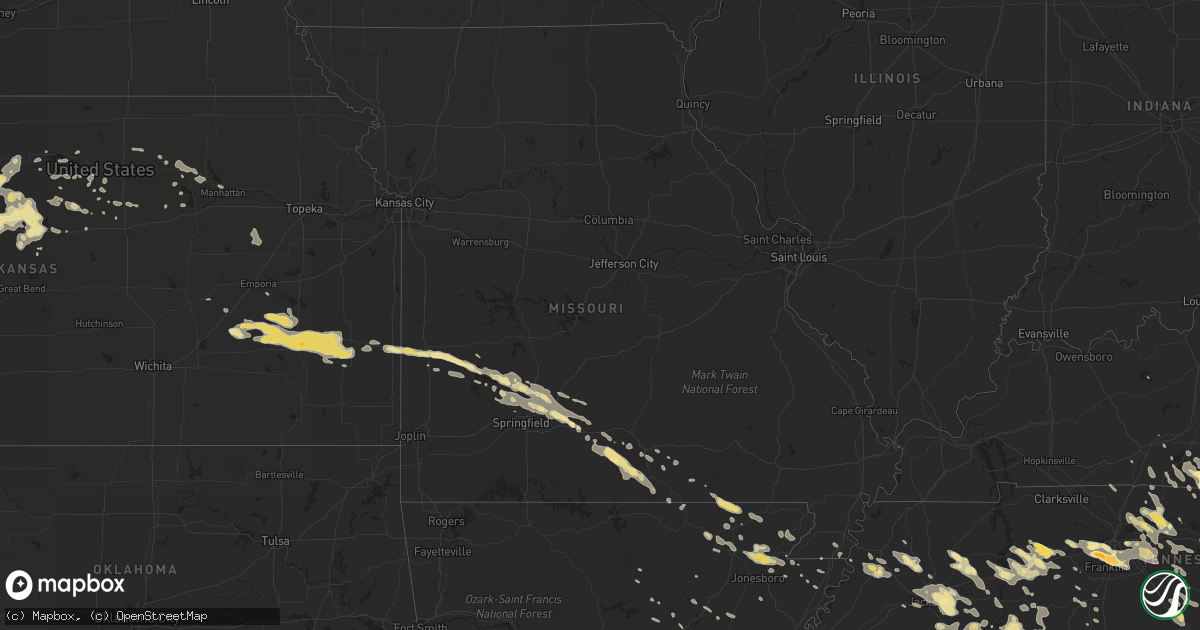
Hail Map in Missouri on July 14, 2015
Get this storm
July 14 map
$229
one time, instant access
Download today. No call, no setup
Keep the $229
Bought the map and want the full workflow? Apply the entire $229 to a subscription within 7 days. None of it is wasted.
Every map, not just this one
This buys you this map. Subscription and you get every map we run, in the markets you choose from a few cities to whole states to nationwide. Plus real-time alerts the moment a storm fires.
Contact data
Name, contact info, occupancy, even credit band for addresses in the footprint. You go from where it hit to who to call.
Become the source they trust
Unlimited branding weather history reports on demand. You already have the documented answer ready for the property owner, and you are the one who showed up with it.
Property data and RoofTrace estimates
Pull up any address you have got, its value and the exact code rules for that jurisdiction, straight from One Click Code. Then RoofTrace estimates the squares, pitch, and roof value, priced the way you price.
Storm reports in Missouri
Missouri
| Date | Description |
|---|---|
| 07/14/20153:28 PM CDT | Trees down in cardwell. |
| 07/14/20151:40 PM CDT | Report of powerlines and trees down. Most main roads are blocked by trees or powerlines. Also received twitter public report of an estimated 60-70 mph wind. |
| 07/14/20151:08 PM CDT | Trees and limbs down up to eight inches in diameter. |
| 07/14/201512:58 PM CDT | Trees down across road on old rolla road. |
| 07/14/201512:42 PM CDT | A local report indicates 58 MPH wind near CABOOL |
| 07/14/201512:15 PM CDT | Damage to a barn. Large limbs down. |
| 07/14/201512:15 PM CDT | Mshp reports part of a roof blown into traffic near the 107 mile marker on i-44. Traffic blocked. |
| 07/14/201512:00 PM CDT | Large 8 inch diameterr limb down on highway 125. |
| 07/14/201511:58 AM CDT | Small 1 inch limbs down from hwy 123 to fr 42 and from fr 91 to fr 79 in northern greene county. Time estimated based on radar. |
| 07/14/201511:51 AM CDT | Trailer park on plank school road had some mobile homes that slid off of their piers. |
| 07/14/201511:51 AM CDT | Numerous large trees down. Time based on radar estimate. |
| 07/14/201511:45 AM CDT | Limbs to 6 inches in diameter down on banning street in town. |
| 07/14/201511:43 AM CDT | Road signs and trees down. |
| 07/14/201511:41 AM CDT | North pitts st had tree uprooted. Electric out along with stop lights. Also trees down on washington street. |
| 07/14/201511:41 AM CDT | Over 100 trees uprooted or snapped off. Power poles snapped halfway up. Extensive power lines down. Dozens of trees on homes. Some shingle damage and roof peelings. Sev |
| 07/14/201511:41 AM CDT | Tree limbs down and a large metal swing set blown over. |
| 07/14/201511:31 AM CDT | A few trees reported down near farm road 34 and highway 13. |
| 07/14/201511:31 AM CDT | A local report indicates 1.00 inch wind near 4 ENE MORRISVILLE |
| 07/14/201511:25 AM CDT | 10 inch diameter tree branch snapped 1 mile south of fair grove along highway 125. Time estimated based on radar. |
| 07/14/201511:10 AM CDT | Nickle hail also reported with the wind gust. |
| 07/14/201511:10 AM CDT | Tree down at teh intersection of farmer and cherry streets in town. Time estimated from radar. |
| 07/14/201511:05 AM CDT | Power lines and 5 inch diameter limb down along buffalo road in town. |
| 07/14/201511:03 AM CDT | Tree damage reported near the intersections of county roads s170 and e530. |
| 07/14/201510:50 AM CDT | Two inch diameter limbs down. |
| 07/14/201510:49 AM CDT | Roof damage to a barn. Picture relayed on social media from local tv station. |
All States Impacted by Hail Map on July 14, 2015
Cities Impacted by Hail Map on July 14, 2015
- Morland, KS
- Clayton, KS
- Selden, KS
- Rapid City, SD
- Only, TN
- Hurricane Mills, TN
- Nunnelly, TN
- Waverly, TN
- McEwen, TN
- Centerville, TN
- Crossville, TN
- Crab Orchard, TN
- Oakdale, TN
- Rockwood, TN
- Harriman, TN
- Ruidoso Downs, NM
- Arcadia, NE
- Lebanon, TN
- Winner, SD
- Gamaliel, KY
- Tompkinsville, KY
- Hestand, KY
- Oconto, NE
- Valentine, NE
- Parshall, ND
- New Town, ND
- Sardis, TN
- Adamsville, TN
- Morris Chapel, TN
- Saltillo, TN
- Crump, TN
- Savannah, TN
- Stapleton, NE
- Bowersville, GA
- Canon, GA
- Eureka, KS
- Paragould, AR
- Velva, ND
- Minot, ND
- Surrey, ND
- Grafton, ND
- Hoople, ND
- Park River, ND
- Pleasanton, NE
- Beaver, OH
- Waverly, OH
- Sundance, WY
- Elkhart, KS
- Walsh, CO
- Campo, CO
- Nevada, MO
- Stockton, MO
- Jerico Springs, MO
- El Dorado Springs, MO
- Moundville, MO
- Deerfield, MO
- Sheldon, MO
- Fort Scott, KS
- Milo, MO
- Voltaire, ND
- Bryson City, NC
- Almond, NC
- Jackson, TN
- Quincy, KY
- Ord, NE
- Burwell, NE
- Lead, SD
- Teasdale, UT
- Arnold, NE
- Callaway, NE
- Yates Center, KS
- Elsmore, KS
- Virgil, KS
- Savonburg, KS
- Piqua, KS
- Humboldt, KS
- La Harpe, KS
- Iola, KS
- Toronto, KS
- Neosho Falls, KS
- Iron City, TN
- Florence, AL
- Holly, CO
- Bazine, KS
- Alexander, KS
- Hoxie, KS
- Stratton, CO
- Bethune, CO
- Lancaster, MN
- Morrisville, MO
- Marshfield, MO
- Half Way, MO
- Brighton, MO
- Bolivar, MO
- Pleasant Hope, MO
- Elkland, MO
- Fair Grove, MO
- Buffalo, MO
- Martin, GA
- Lavonia, GA
- Burlington, CO
- Huntsville, AL
- Huntland, TN
- Belvidere, TN
- Bel Air, MD
- Minneapolis, KS
- Bennington, KS
- Andrews, NC
- Marble, NC
- Briceville, TN
- Caryville, TN
- Johnson, KS
- Nolensville, TN
- Brentwood, TN
- Nashville, TN
- Franklin, TN
- Osceola, AR
- Park, KS
- Tallahassee, FL
- Crawfordville, FL
- Natoma, KS
- Ada, OH
- Lima, OH
- Fort Jennings, OH
- Columbus Grove, OH
- Hazelton, ND
- Gilbert, AZ
- Chandler, AZ
- Robbinsville, NC
- Chattanooga, TN
- Strafford, MO
- Chippewa Lake, OH
- Seville, OH
- Medina, OH
- Kennesaw, GA
- Garryowen, MT
- Page, NE
- Winnetoon, NE
- Orchard, NE
- Ezel, KY
- Vona, CO
- Petersburg, TN
- Pulaski, TN
- Frankewing, TN
- Dyersburg, TN
- Friendship, TN
- Glasco, KS
- Tullahoma, TN
- Clearville, PA
- Quinter, KS
- Woodston, KS
- Plainville, KS
- Alton, KS
- Cookeville, TN
- Williston, ND
- Bogue, KS
- Damar, KS
- Donalsonville, GA
- Dresden, KS
- Sparks, GA
- Summerville, GA
- Mentone, AL
- Lyerly, GA
- Menlo, GA
- Gaylesville, AL
- White Bluff, TN
- Hazlehurst, GA
- Palco, KS
- Hill City, KS
- Pall Mall, TN
- Jamestown, TN
- Byrdstown, TN
- Monroe, TN
- Albany, KY
- Monette, AR
- Black Oak, AR
- Idalia, CO
- Garden City, KS
- Madison, AL
- Lucasville, OH
- Argillite, KY
- West Portsmouth, OH
- West Union, OH
- Portsmouth, OH
- Lynx, OH
- Stout, OH
- South Portsmouth, KY
- Vanceburg, KY
- Olive Hill, KY
- Otway, OH
- Wheelersburg, OH
- Ironton, OH
- Friendship, OH
- Greenup, KY
- Worthington, KY
- Blue Creek, OH
- Franklin Furnace, OH
- Manchester, OH
- Grayson, KY
- Peebles, OH
- Garrison, KY
- South Shore, KY
- Maxwell, NE
- Anselmo, NE
- Cheyenne Wells, CO
- Pottersville, MO
- Drury, MO
- Dora, MO
- Vanzant, MO
- West Plains, MO
- Elyria, NE
- Murphy, NC
- Ness City, KS
- Burkesville, KY
- Duff, TN
- La Follette, TN
- Pioneer, TN
- Newcomb, TN
- Hoskins, NE
- Lobelville, TN
- Holladay, TN
- Ripley, WV
- Trenton, TN
- Litchfield, NE
- Loup City, NE
- Ardmore, TN
- Dellrose, TN
- Seymour, MO
- Dahlonega, GA
- Suches, GA
- Campton, KY
- Rockbridge, OH
- Topton, NC
- Walnut Ridge, AR
- Pocahontas, AR
- Sparta, TN
- Jefferson City, TN
- New Market, TN
- Dandridge, TN
- Burbank, OH
- Lodi, OH
- West Salem, OH
- Homerville, OH
- Jackson, OH
- Bunker Hill, KS
- Dorrance, KS
- Springfield, CO
- Rogersville, TN
- Whitesburg, TN
- Waynesboro, TN
- Dadeville, MO
- Dickson, TN
- Hartsville, TN
- Gallatin, TN
- Castalian Springs, TN
- Bethpage, TN
- Harvest, AL
- Jonesboro, AR
- Beech Grove, AR
- Brookland, AR
- Bono, AR
- Register, GA
- Le Roy, WV
- Baxter, TN
- Monterey, TN
- Bloomington Springs, TN
- Pompano Beach, FL
- Deerfield Beach, FL
- Holcomb, KS
- Dola, OH
- Kenton, OH
- Epping, ND
- Emporia, KS
- Farner, TN
- Madisonville, TN
- Sweetwater, TN
- Englewood, TN
- Tellico Plains, TN
- Reliance, TN
- Turtletown, TN
- Vonore, TN
- Woodbine, KY
- Riddleton, TN
- Dixon Springs, TN
- Letart, WV
- Leon, WV
- Glasgow, KY
- Gainesboro, TN
- Dalhart, TX
- Piketon, OH
- Manila, AR
- Tescott, KS
- Clarkrange, TN
- Ethridge, TN
- Rogersville, AL
- Page, ND
- Hope, ND
- Monticello, KY
- Carlisle, KY
- Owingsville, KY
- Flemingsburg, KY
- Sharpsburg, KY
- Hillsboro, KY
- Moorefield, KY
- Ewing, KY
- Keyes, OK
- Boise City, OK
- Humboldt, TN
- Evensville, TN
- Gridley, KS
- Madison, KS
- Livingston, TN
- Fairburn, SD
- Falkville, AL
- Adairsville, GA
- Stanton, NE
- Athens, AL
- Front Royal, VA
- Imboden, AR
- Ravenden, AR
- Hazard, NE
- Pierce, NE
- Norfolk, NE
- Chickamauga, GA
- Trenton, GA
- La Fayette, GA
- Rising Fawn, GA
- Lookout Mountain, GA
- Wildwood, GA
- Wakeeney, KS
- Collyer, KS
- Comstock, NE
- Keystone, SD
- Deadwood, SD
- Ellis, KS
- Lakeland, GA
- Ray City, GA
- Leitchfield, KY
- Grenora, ND
- Sugar Tree, TN
- Camden, TN
- Lamar, CO
- Hammonton, NJ
- Grimsley, TN
- Deer Lodge, TN
- Willow Springs, MO
- Pomona, MO
- McRae Helena, GA
- Mammoth Spring, AR
- Minto, ND
- Forest River, ND
- Gove, KS
- Minford, OH
- Leachville, AR
- Trion, GA
- Maynard, AR
- Couch, MO
- Gatewood, MO
- Warm Springs, AR
- Hill City, SD
- Columbia, TN
- Athens, OH
- Clayton, NM
- Quincy, FL
- Mount Juliet, TN
- Center, ND
- Williamstown, WV
- Fleming, OH
- Marietta, OH
- New Holland, OH
- Chillicothe, OH
- Frankfort, OH
- Ransom, KS
- Utica, KS
- Philadelphia, TN
- Cairo, OH
- Rush Center, KS
- Walnut, MS
- Black Rock, AR
- Saint Xavier, MT
- Foxhome, MN
- Henderson, TN
- Bethel Springs, TN
- Finger, TN
- Willard, MO
- Franklin, NC
- Gassaway, WV
- Exchange, WV
- Helenwood, TN
- Balfour, ND
- Newcastle, WY
- Leoti, KS
- Deerfield, KS
- Marienthal, KS
- Scott City, KS
- Boynton Beach, FL
- Hamilton, KS
- Vincent, OH
- Harrison, TN
- Hixson, TN
- Manchester, TN
- Alma, NE
- Republican City, NE
- Hohenwald, TN
- Lawrenceburg, TN
- Gallina, NM
- Rocky Top, TN
- Nelsonville, OH
- Logan, OH
- Haydenville, OH
- Union Furnace, OH
- Miracle, KY
- Pineville, KY
- Middlesboro, KY
- Beloit, KS
- Tipton, KS
- Hunter, KS
- Tyrone, PA
- Warriors Mark, PA
- Rome, GA
- Kingston, GA
- Blytheville, AR
- Manhattan, KS
- Swainsboro, GA
- Soperton, GA
- Lyons, GA
- Blackshear, GA
- Linden, TN
- Collinwood, TN
- Westpoint, TN
- Lenora, KS
- Norton, KS
- Dublin, GA
- Mays Landing, NJ
- Egg Harbor Township, NJ
- Holland, KY
- Scottsville, KY
- Lafayette, TN
- Lodge Grass, MT
- Hasty, CO
- Rickman, TN
- Allred, TN
- Crawford, TN
- Alpine, TN
- Dayton, TN
- Rienzi, MS
- Ruckersville, VA
- Stanardsville, VA
- Madison, VA
- Hood, VA
- Upton, WY
- Abiquiu, NM
- Bulls Gap, TN
- Mosheim, TN
- Greeneville, TN
- Osborne, KS
- Bidwell, OH
- Gallipolis, OH
- Gallipolis Ferry, WV
- Bald Knob, AR
- Clifton, TN
- Kingston, TN
- Hays, KS
- Somerset, KY
- Sabina, OH
- Washington Court House, OH
- Morrison, TN
- Bradyville, TN
- Newport, AR
- McCrory, AR
- Millville, NJ
- Cedar Grove, TN
- Huntingdon, TN
- Wilder, TN
- Mountain View, AR
- Wilson, KS
- Ellsworth, KS
- Broken Bow, NE
- Ball Ground, GA
- Jasper, GA
- Gillette, WY
- Creston, OH
- Laceys Spring, AL
- Sylvania, GA
- Millen, GA
- Rocky Ford, GA
- Clay Center, KS
- Heaters, WV
- Napier, WV
- Pennsylvania Furnace, PA
- Moss, TN
- Eubank, KY
- Mount Vernon, KY
- London, KY
- Wilmington, OH
- Leesburg, OH
- New Vienna, OH
- Cincinnati, OH
- Ft Mitchell, KY
- Covington, KY
- Erlanger, KY
- Florence, KY
- Hebron, KY
- Pegram, TN
- Thorn Hill, TN
- Mooresburg, TN
- Sneedville, TN
- Almond, NY
- Arkport, NY
- Hayesville, NC
- Brasstown, NC
- Milan, TN
- Medina, TN
- Perham, MN
- Blanchester, OH
- Fayetteville, OH
- Benton, TN
- Delano, TN
- Cullman, AL
- Bascom, FL
- Martinsville, OH
- Bells, TN
- Creighton, NE
- Blairsville, GA
- Mason City, NE
- Emerson, KY
- Young, AZ
- Stockport, OH
- Waterford, OH
- Lakeside, NE
- Vina, AL
- Oak Hill, OH
- South Webster, OH
- Alexander, ND
- Watford City, ND
- Tishomingo, MS
- Bristolville, OH
- North Bloomfield, OH
- Cortland, OH
- Fairmount, ND
- Campbell, MN
- Tintah, MN
- Bolivar, TN
- Hickory Valley, TN
- Catharine, KS
- Lascassas, TN
- Murfreesboro, TN
- La Vergne, TN
- Smyrna, TN
- Westport, TN
- Trezevant, TN
- Yuma, TN
- McKenzie, TN
- Buena Vista, TN
- Hanceville, AL
- Crane Hill, AL
- Bremen, AL
- South Solon, OH
- Bloomingburg, OH
- Mount Sterling, OH
- London, OH
- Broxton, GA
- Beersheba Springs, TN
- Altamont, TN
- Harrod, OH
- Tanner, AL
- Mansfield, MO
- Hitchins, KY
- Denton, KY
- Tremont, MS
- Hamilton, AL
- Anderson, AL
- Lexington, AL
- Rector, AR
- Marmaduke, AR
- Delray Beach, FL
- Transfer, PA
- Greenville, PA
- Fredonia, PA
- McClave, CO
- Townsend, TN
- Cord, AR
- Newark, AR
- Antioch, TN
- New Haven, KY
- Raywick, KY
- New Hope, KY
- Campbellsville, KY
- Charleston, WV
- Georgetown, OH
- Hamersville, OH
- Prospect, TN
- Ardmore, AL
- Taft, TN
- Fayetteville, TN
- Pritchett, CO
- Luttrell, TN
- Maynardville, TN
- Powder Springs, TN
- Hillsboro, OH
- Sunbright, TN
- Robbins, TN
- Frederick, MD
- Middletown, MD
- Delphos, KS
- Huron, TN
- Scotts Hill, TN
- Lexington, TN
- Reagan, TN
- Lula, GA
- Murrayville, GA
- Cleveland, GA
- Mountain View, MO
- Milford Center, OH
- North Lewisburg, OH
- Pangburn, AR
- Lake City, FL
- Hermosa, SD
- Tohatchi, NM
- Eustis, FL
- Spencer, TN
- Lake City, AR
- Young Harris, GA
- Warne, NC
- Fair Play, MO
- Aldrich, MO
- Rutland, OH
- Mason, WV
- West Columbia, WV
- Pomeroy, OH
- Racine, OH
- Hartford, WV
- Syracuse, OH
- Elkton, VA
- Dunlap, TN
- Strandquist, MN
- Red Boiling Springs, TN
- Mount Hermon, KY
- Celina, TN
- Fountain Run, KY
- Paradise, KS
- Waldo, KS
- Ten Mile, TN
- Augusta, AR
- Chelsea, AL
- Brush Creek, TN
- Liberty, TN
- Alexandria, TN
- Watertown, TN
- Luray, TN
- Beech Bluff, TN
- Mesa, AZ
- Wellington, FL
- West Palm Beach, FL
- Blaine, TN
- Strawberry Plains, TN
- Newport, TN
- Rutledge, TN
- Ravenswood, WV
- Millwood, WV
- Mountain Grove, MO
- Norwood, MO
- Jacksonville, GA
- New Marshfield, OH
- Albany, OH
- Norwich, ND
- Granville, ND
- Karlsruhe, ND
- Whitwell, TN
- Weskan, KS
- Culleoka, TN
- Starkweather, ND
- Nancy, KY
- Stearns, KY
- Jamestown, KY
- Hackleburg, AL
- Alpha, KY
- Ansley, NE
- Mcminnville, TN
- Woodbury, TN
- Nahunta, GA
- Spring City, TN
- Decatur, TN
- Calvin, KY
- New Knoxville, OH
- Wapakoneta, OH
- Toney, AL
- Westminster, SC
- Toccoa, GA
- Sharps Chapel, TN
- Hornell, NY
- Moshannon, PA
- Thornville, OH
- Heath, OH
- Simpson, KS
- Means, KY
- Frenchburg, KY
- Salt Lick, KY
- Olympia, KY
- Langsville, OH
- Ty Ty, GA
- Sumner, GA
- Jennings, KS
- Guin, AL
- Alamo, GA
- Claflin, KS
- Hoisington, KS
- Phelps, KY
- Thayer, MO
- Koshkonong, MO
- Russell Springs, KY
- Newfolden, MN
- Cotton Plant, AR
- McCracken, KS
- Clinton, TN
- Andersonville, TN
- Norris, TN
- Ray, OH
- Sequatchie, TN
- Jasper, TN
- Guild, TN
- Signal Mountain, TN
- Owyhee, NV
- Mountain City, NV
- Kingston Springs, TN
- Charlotte, TN
- Woodstock, GA
- Acworth, GA
- New York Mills, MN
- Frazee, MN
- Athens, TN
- Riceville, TN
- Calhoun, GA
- Armuchee, GA
- Finley, TN
- White, GA
- Portland, TN
- Goodlettsville, TN
- Carthage, TN
- Westmoreland, TN
- Hendersonville, TN
- Gordonsville, TN
- Fortuna, ND
- Douglas, GA
- Concord, VA
- Lynchburg, VA
- Middletown, VA
- Capon Bridge, WV
- Augusta, WV
- Stephens City, VA
- High View, WV
- Delray, WV
- Wardensville, WV
- Strasburg, VA
- Star Tannery, VA
- Rio, WV
- Yellow Spring, WV
- Winchester, VA
- Middleton, TN
- Saulsbury, TN
- Lincoln, KS
- Nemo, SD
- Rushsylvania, OH
- Ridgeway, OH
- Uniontown, KS
- Redfield, KS
- Plainville, GA
- Mount Berry, GA
- Tazewell, TN
- Rose Hill, VA
- Ewing, VA
- Beeler, KS
- Syracuse, KS
- Cartersville, GA
- Sewell, NJ
- Blackwood, NJ
- Sicklerville, NJ
- Valhermoso Springs, AL
- Somerville, AL
- Smithville, TN
- Penokee, KS
- Merna, NE
- Arrington, VA
- Shipman, VA
- Brodhead, KY
- Berea, KY
- Woodburn, KY
- Artemas, PA
- Halls, TN
- Ava, MO
- Russellville, AL
- Phil Campbell, AL
- Riley, KS
- Osmond, NE
- Plainview, NE
- Denhoff, ND
- Lafe, AR
- Bronson, KS
- Flintstone, MD
- Conway, MO
- Niangua, MO
- Iuka, MS
- Burnsville, MS
- Dyer, TN
- Stoutsville, OH
- Walnut Grove, MO
- Carbon Hill, AL
- Eldridge, AL
- Berry, AL
- Bankston, AL
- Hermitage, TN
- Milton, TN
- Auburntown, TN
- Hurdsfield, ND
- Austin, IN
- Crothersville, IN
- Moran, KS
- Hazel Green, KY
- Vancleve, KY
- Fayette, AL
- Glennville, GA
- Walker, KS
- Lucas, KS
- Russell, KS
- Luray, KS
- Victoria, KS
- Gorham, KS
- Etoile, KY
- Hilham, TN
- Minster, OH
- Michie, TN
- Winchester, TN
- Decherd, TN
- Estill Springs, TN
- Lynchburg, TN
- Romney, WV
- Purgitsville, WV
- Willow Wood, OH
- Kitts Hill, OH
- Gates, TN
- Flatwoods, KY
- Russell, KY
- Kenton, TN
- Rutherford, TN
- Birch Tree, MO
- Biggers, AR
- Town Creek, AL
- Karthaus, PA
- Kit Carson, CO
- Pikeville, TN
- Woodville, AL
- Downs, KS
- Ooltewah, TN
- Parsons, TN
- Pedro, OH
- Chagrin Falls, OH
- Jeffersonville, OH
- Jamestown, OH
- Springfield, MO
- Burlington, KS
- Le Roy, KS
- Lenoir City, TN
- Loudon, TN
- Trumann, AR
- Harrisburg, AR
- Clifton, KS
- Morganville, KS
- Primm Springs, TN
- Bon Aqua, TN
- Fairview, TN
- Palmer, TN
- Buchanan, GA
- Wallace, NE
- Kanorado, KS
- Smithville, WV
- Barnard, KS
- Given, WV
- Evans, WV
- Greenfield, OH
- Tryon, NE
- Sterling, OH
- Smithville, OH
- Bradford, AR
- Strunk, KY
- Paw Paw, WV
- Great Cacapon, WV
- Otto, NC
- Sautee Nacoochee, GA
- Helen, GA
- Hope, KY
- Williamsport, OH
- Clarksburg, OH
- Danville, AL
- Petroleum, WV
- Waverly, WV
- Saint Marys, WV
- Walker, WV
- Gordon, AL
- Malone, FL
- Hartselle, AL
- Decatur, AL
- Ewing, NE
- Hillsboro, TN
- Boyce, VA
- Morehead, KY
- Jeffersonville, KY
- Mount Sterling, KY
- Clewiston, FL
- Bowling Green, KY
- Green River, UT
- Winfield, TN
- Elfrida, AZ
- Moorcroft, WY
- Bear Creek, AL
- Haleyville, AL
- Lancing, TN
- Birmingham, AL
- Gruetli Laager, TN
- Coalmont, TN
- Delaplane, VA
- Markham, VA
- Ohio City, OH
- Wakefield, KS
- Clyde, KS
- Concordia, KS
- Arrington, TN
- Ideal, SD
- Cleveland, TN
- Lynchburg, OH
- Midland, OH
- Mullica Hill, NJ
- Monroeville, NJ
- Hornsby, TN
- Olivehill, TN
- Selmer, TN
- Enville, TN
- Bath Springs, TN
- Lutts, TN
- Milledgeville, TN
- Sonoita, AZ
- Jackson, KY
- South Salem, OH
- Clarksville, OH
- Harveysburg, OH
- Waynesville, OH
- Thedford, NE
- Reno, OH
- Glen Elder, KS
- Datto, AR
- Corning, AR
- Roseglen, ND
- Flatwoods, WV
- Union Grove, AL
- Kingston, OH
- Circleville, OH
- Cheshire, OH
- Point Pleasant, WV
- Hartville, MO
- Grovespring, MO
- Denmark, TN
- Orlando, KY
- Summerton, SC
- Williamstown, NJ
- Newfield, NJ
- Guys, TN
- Crab Orchard, KY
- Waynesburg, KY
- Alvaton, KY
- Lake Worth, FL
- Bainbridge, OH
- Williamsport, TN
- Santa Fe, TN
- Bryant, AL
- Sparta, KY
- Sanders, KY
- New Liberty, KY
- Flat Lick, KY
- Walker, KY
- Sandy Hook, KY
- Wartburg, TN
- Brilliant, AL
- Williamsburg, OH
- Mount Orab, OH
- Goshen, OH
- Sardinia, OH
- Otis, KS
- Paint Lick, KY
- Sylvan Grove, KS
- Pataskala, OH
- Granville, OH
- Blacklick, OH
- Johnstown, OH
- Alexandria, OH
- New Albany, OH
- Columbus, OH
- Westerville, OH
- Stockton, KS
- Denton, GA
- Erie, KS
- Claxton, GA
- Oil Trough, AR
- Rocklake, ND
- Clearfield, KY
- Whitleyville, TN
- Summer Shade, KY
- Austin, KY
- Walling, TN
- Hebron, OH
- Soddy Daisy, TN
- Sale Creek, TN
- Graysville, TN
- Loxahatchee, FL
- Huntsville, TN
- East Bernstadt, KY
- Menoken, ND
- Pinson, TN
- Oakfield, TN
- Slanesville, WV
- Bloomery, WV
- Eskridge, KS
- Beaumont, KY
- Edmonton, KY
- Greenback, TN
- Woodstown, NJ
- Breckenridge, MN
- Old Fort, TN
- Maineville, OH
- West Chester, OH
- Mason, OH
- Middletown, OH
- Dawsonville, GA
- Floral, AR
- Saint Francis, KS
- Hiawassee, GA
- New Carlisle, OH
- Tremont City, OH
- Springfield, OH
- Casstown, OH
- Saint Paris, OH
- Christiansburg, OH
- Urbana, OH
- Conover, OH
- Troy, OH
- La Crosse, KS
- Alma, KS
- Tallassee, TN
- Maryville, TN
- Walland, TN
- Fulton, MS
- Springfield, TN
- Orlinda, TN
- Adairville, KY
- Wahpeton, ND
- Brady, NE
- Van Wert, OH
- Convoy, OH
- Henagar, AL
- Lebanon, OH
- Monroe, OH
- Alamo, TN
- Fisher, AR
- Tracy City, TN
- Chambers, NE
- Powhatan, AR
- McDonald, TN
- Apison, TN
- Yulee, FL
- Cypress Inn, TN
- Knoxville, TN
- Corryton, TN
- Boston, KY
- Millersburg, OH
- Sugarcreek, OH
- Decaturville, TN
- Winchester, OH
- Adel, GA
- Humansville, MO
- West Farmington, OH
- Solomon, KS
- Chatsworth, GA
- Matfield Green, KS
- Arapahoe, CO
- Goodrich, ND
- Rydal, GA
- Fairmount, GA
- Morrow, OH
- South Lebanon, OH
- Middletown, DE
- Elkton, MD
- Chesapeake City, MD
- Newark, DE
- Bear, DE
- Peace Valley, MO
- Muscle Shoals, AL
- Killen, AL
- Chanute, KS
- Wellston, OH
- Hamden, OH
- Vinton, OH
- Kim, CO
- La Junta, CO
- Lynnville, TN
- Wooster, OH
- Niota, TN
- Newbern, TN
- Buffalo Valley, TN
- Lancaster, TN
- Alton, MO
- Ripley, OH
- Corbin, KY
- Gray, KY
- Steele, MO
- Burnside, KY
- Bronston, KY
- Whitley City, KY
- Nashville, GA
- Abilene, KS
- Sheridan, WY
- Appomattox, VA
- Spout Spring, VA
- Canton, GA
- Valley Head, AL
- Guysville, OH
- Pleasant Hill, TN
- Allons, TN
- Granville, TN
- Mountain Rest, SC
- Long Creek, SC
- Rochelle, VA
- Aroda, VA
- Radiant, VA
- Orange, VA
- Kenna, WV
- Egg Harbor City, NJ
- Darden, TN
- Wildersville, TN
- Smiths Grove, KY
- Oakland, KY
- Loretto, KY
- Saint Francis, KY
- Birchwood, TN
- West Liberty, KY
- Belpre, OH
- Stuart, FL
- Hobe Sound, FL
- Junction City, KS
- Chapman, KS
- Resaca, GA
- Barbourville, KY
- Gregory, SD
- Dallas, SD
- Pilger, NE
- Hunter, AR
- Burns, TN
- New Johnsonville, TN
- Lyles, TN
- Winfield, AL
- Neligh, NE
- Manter, KS
- Glen, MS
- Beechgrove, TN
- Loveland, OH
- Pleasant Plain, OH
- Mount Vernon, GA
- Silver Point, TN
- Londonderry, OH
- Richmond Dale, OH
- Leonardville, KS
- Green, KS
- Dunnegan, MO
- Fordland, MO
- Rogersville, MO
- Columbia, KY
- South Pittsburg, TN
- Elkmont, AL
- Etowah, TN
- Saint Marys, OH
- Martin, KY
- Drasco, AR
- Concord, AR
- Egeland, ND
- Morganton, GA
- Blue Ridge, GA
- Portis, KS
- Ogallah, KS
- Pfeifer, KS
- Cedar Point, KS
- Sandy Ridge, PA
- Philipsburg, PA
- Ranger, GA
- Baileyton, AL
- Eva, AL
- Joppa, AL
- Aniwa, WI
- Antigo, WI


