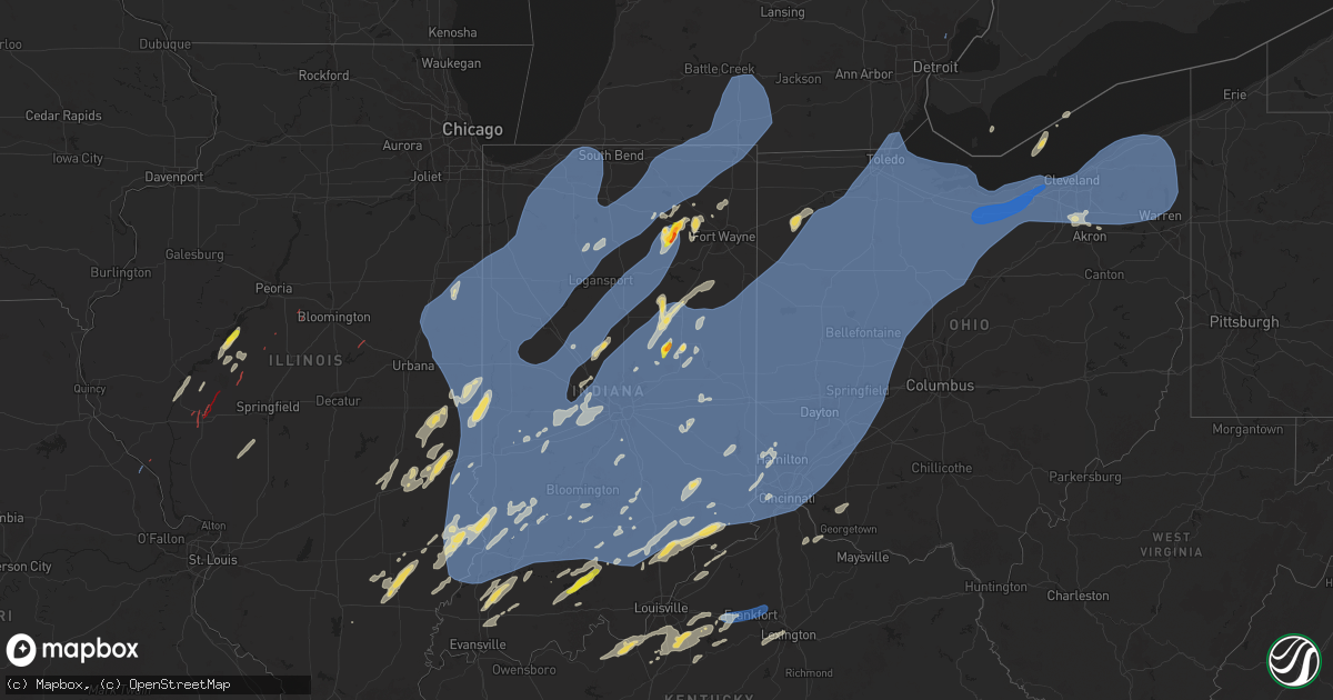
Hail Map on June 18, 2025
Get this storm
June 18 map
$229
one time, instant access
Download today. No call, no setup
Keep the $229
Bought the map and want the full workflow? Apply the entire $229 to a subscription within 7 days. None of it is wasted.
Every map, not just this one
This buys you this map. Subscription and you get every map we run, in the markets you choose from a few cities to whole states to nationwide. Plus real-time alerts the moment a storm fires.
Contact data
Name, contact info, occupancy, even credit band for addresses in the footprint. You go from where it hit to who to call.
Become the source they trust
Unlimited branding weather history reports on demand. You already have the documented answer ready for the property owner, and you are the one who showed up with it.
Property data and RoofTrace estimates
Pull up any address you have got, its value and the exact code rules for that jurisdiction, straight from One Click Code. Then RoofTrace estimates the squares, pitch, and roof value, priced the way you price.
States Impacted by Hail Map on June 18, 2025
Storm reports
Maryland
| Date | Description |
|---|---|
| 06/18/20253:10 PM CDT | Multiple trees down. Time estimated from radar. |
| 06/18/20253:09 PM CDT | Multiple trees down. Time estimated from radar. |
| 06/18/20253:04 PM CDT | Multiple trees down. Time estimated from radar. |
| 06/18/20253:04 PM CDT | Tree into a house. Time estimated from radar. |
| 06/18/20253:00 PM CDT | Multiple trees and limbs down along crouse mill road. Some trees uprooted or snapped. Time estimated from radar. |
| 06/18/20252:58 PM CDT | Multiple trees down on rt 404 in queen anne. Time estimated from radar. |
| 06/18/20252:53 PM CDT | Tree down on chapel road. Time estimated from radar. |
| 06/18/20251:57 PM CDT | Trees down near the 5700 block of trotter rd. |
| 06/18/20251:31 PM CDT | Quarter size hail |
| 06/18/20251:24 PM CDT | A tree was down along severn chapel road in crownsville. |
| 06/18/20251:22 PM CDT | Quarter sized hail estimated near odenton. |
| 06/18/20251:17 PM CDT | A local report indicates 1.25 inch wind near Fort Meade |
| 06/18/20251:15 PM CDT | A local report indicates 1.25 inch wind near 1 ENE Severn |
| 06/18/20251:14 PM CDT | Multiple trees and large branches were snapped |
| 06/18/202512:21 PM CDT | Trees down near the intersection of brinks rd and woodfield rd. |
Iowa
| Date | Description |
|---|---|
| 06/18/20252:59 PM CDT | [landspout] brief landspout tornado persisted for one minute between park view and eldridge. |
Delaware
| Date | Description |
|---|---|
| 06/18/20253:50 PM CDT | Tree down. Time estimated from radar. |
| 06/18/20253:28 PM CDT | Wires down on church street. Time from report. |
Ohio
| Date | Description |
|---|---|
| 06/18/20256:59 PM CDT | Six inch limb blown down. |
| 06/18/20256:59 PM CDT | 1 foot diameter healthy tree uprooted. Relayed by ham radio group. |
| 06/18/20256:58 PM CDT | Measured wind gust at river valley high school. Several medium-sized tree branches were also downed. |
| 06/18/20256:56 PM CDT | One foot diameter tree blown down. |
| 06/18/20256:55 PM CDT | Tree limbs down. Time estimated from radar. |
| 06/18/20256:52 PM CDT | Damage to roof and windows of a house. |
| 06/18/20256:51 PM CDT | Photo of several large limbs snapped off of a tree in bloomville. |
| 06/18/20256:50 PM CDT | Large tree down as well as power lines. Time estimated by radar. |
| 06/18/20256:50 PM CDT | Measured 59 mph gust in martin relayed by ham radio. |
| 06/18/20256:50 PM CDT | An nws cleveland storm survey determined that an ef-0 tornado occurred northeast of rocky ridge on june 18... 2025. The tornado touched down on the west side of toussai |
| 06/18/20256:47 PM CDT | Large trees down. |
| 06/18/20256:47 PM CDT | Multiple large trees downed just south of tiffin. |
| 06/18/20256:46 PM CDT | Eighteen inch diameter tree blown onto power lines. |
| 06/18/20256:45 PM CDT | Large tree limbs downed in marion. Video received on social media. |
| 06/18/20256:44 PM CDT | Tree blown onto power lines. |
| 06/18/20256:43 PM CDT | An nws cleveland storm survey determined that an ef-0 tornado occurred north of elmore on june 18... 2025. The tornado was brief... Touching down on the northwest corne |
| 06/18/20256:43 PM CDT | Grain silo destroyed... Minor damage to other structures... And tree limbs downed. Report noted seeing rotating winds and power flashes. |
| 06/18/20256:41 PM CDT | Large tree downed onto a power-line over the intersection of 163 and superior street. |
| 06/18/20256:39 PM CDT | One large tree snapped off and fell on a house on bent tree drive. |
| 06/18/20256:35 PM CDT | Asos station kluk cincinnati lunken field. |
| 06/18/20256:34 PM CDT | Commercial awning collapsed. Report relayed by ham radio group. |
| 06/18/20256:34 PM CDT | Utility pole snapped in the police dept. South lot and the city building. |
| 06/18/20256:31 PM CDT | Several downed trees and power-lines in carey... Including one tree blocking a road. |
| 06/18/20256:30 PM CDT | Large tree down on a house. |
| 06/18/20256:27 PM CDT | 2 foot diameter rotted tree down at the 1600 block of park street in findlay. Relayed by ham radio group. |
| 06/18/20256:27 PM CDT | Tree downed along dorr road near the 13abc studios. |
| 06/18/20256:27 PM CDT | Several 1 to 2 foot diameter trees snapped at their bases. |
| 06/18/20256:26 PM CDT | Two foot diameter tree blown down. |
| 06/18/20256:24 PM CDT | Large branches blown down. |
| 06/18/20256:23 PM CDT | Mesonet station gw2591 arcadia. |
| 06/18/20256:21 PM CDT | 10 inch diameter branch caused damage to house roof and porch. Time estimated from radar data. |
| 06/18/20256:19 PM CDT | Picture received via social media of a tree split and partially snapped off. |
| 06/18/20256:18 PM CDT | A dozen trees downed... Including on some fencing... In the 7000 block of old stage road. Time estimated by radar. |
| 06/18/20256:15 PM CDT | Large tree limb downed onto a car in findlay. |
| 06/18/20256:15 PM CDT | Branches down. |
| 06/18/20256:13 PM CDT | A local report indicates 68 MPH wind near 2 SW Findlay |
| 06/18/20256:13 PM CDT | Shingles blown off house... Large tree split. |
| 06/18/20256:13 PM CDT | Large limbs were downed from a healthy tree. |
| 06/18/20256:13 PM CDT | Tree downed on road... Partially blocking dayton yellowsprings road. Time estimated by radar. |
| 06/18/20256:10 PM CDT | Several large tree limbs down. Time estimated from radar. |
| 06/18/20256:06 PM CDT | Report on facebook of lots tree damage in and around deshler. |
| 06/18/20256:04 PM CDT | Photos of various large branches down. Appears to be some siding damage to a home. |
| 06/18/20256:04 PM CDT | Numerous trees downed throughout the county... Particularly near ada. Time estimated by radar. |
| 06/18/20256:01 PM CDT | 1ft diameter tree down. |
| 06/18/20256:00 PM CDT | Six trees down. Time estimated from radar. |
| 06/18/20256:00 PM CDT | Large tree limbs down. Time estimated by radar. |
| 06/18/20256:00 PM CDT | Large tree down. Time estimated. |
| 06/18/20256:00 PM CDT | Several large tree limbs downed on panjab court. |
| 06/18/20255:58 PM CDT | A large tree limb was downed. |
| 06/18/20255:58 PM CDT | Large tree limbs down. Time estimated from radar. |
| 06/18/20255:57 PM CDT | Large tree fell on a house. |
| 06/18/20255:55 PM CDT | Corrects time of previous tstm wnd dmg report from lakeview. Tree limbs down. Time estimated from radar. |
| 06/18/20255:55 PM CDT | Awos station kowx ottawa. |
| 06/18/20255:54 PM CDT | Two foot diameter tree and power lines blown down. |
| 06/18/20255:54 PM CDT | Kday. |
| 06/18/20255:53 PM CDT | Three 8 inch diameter trees down. |
| 06/18/20255:51 PM CDT | Large tree blown down across worley rd. |
| 06/18/20255:48 PM CDT | One foot diameter tree blown down. |
| 06/18/20255:48 PM CDT | Large branches down. |
| 06/18/20255:47 PM CDT | Corrects report source of previous tstm wnd dmg report from 1 sw lima. Trained spotter reports large tree branches and a few trees down near faurot park in lima. Time e |
| 06/18/20255:46 PM CDT | Very large branch snapped off of tree. |
| 06/18/20255:46 PM CDT | Reports of trees on houses. |
| 06/18/20255:45 PM CDT | Large tree down on woodlawn st. In lima. Time estimated via radar. |
| 06/18/20255:45 PM CDT | Trained spotter estimates gusts up to 60 mph in lima. |
| 06/18/20255:44 PM CDT | Ten to fifteen large trees downed or split at the property. Additionally... The corn crop was damaged by winds. |
| 06/18/20255:44 PM CDT | Large tree down onto car at the intersection of north woodlawn avenue and latham avenue. No known injuries at this time. Time estimated via radar. |
| 06/18/20255:41 PM CDT | Trees and power lines down over the roads in ottoville and kalida areas. |
| 06/18/20255:41 PM CDT | Tree down on west elm street at the roundabout with south fraunfeiter rd. Time estimated via radar. |
| 06/18/20255:40 PM CDT | 6 inch tree limbs downed along stonyridge ave. Time estimated by radar. |
| 06/18/20255:40 PM CDT | Powerlines down on sr 117 between spencerville and lima. |
| 06/18/20255:40 PM CDT | A large tree |
| 06/18/20255:40 PM CDT | Several large tree limbs down. Time estimated from radar. |
| 06/18/20255:38 PM CDT | Tree on a house and large branches blown down. Time estimated from radar. |
| 06/18/20255:25 PM CDT | Mesonet station as860 van wert. |
| 06/18/20255:22 PM CDT | Bell tower collapsed at st marys church in van wert. Time estimated via radar. |
| 06/18/20255:20 PM CDT | 12 power poles down between stripe rd and mendon rd near the vantage career center. Time estimated via radar. |
| 06/18/20255:20 PM CDT | Several trees and power lines down including a tree on a house. |
| 06/18/20255:20 PM CDT | Structural damage to building. Part of roof removed. |
| 06/18/20255:15 PM CDT | A local report indicates 60 MPH wind near 3 WSW Versailles |
| 06/18/20255:08 PM CDT | Tree down on house. |
| 06/18/20255:05 PM CDT | Numerous trees down in tallmadge. |
| 06/18/20255:02 PM CDT | Trees reported oh 4013 8433 ten to fifteen large trees downed or split at the property. Additionally... The corn crop was damaged by winds. |
| 06/18/20255:02 PM CDT | Trees reported down in stow. |
| 06/18/20255:00 PM CDT | A local report indicates 58 MPH wind near Fort Recovery |
| 06/18/20254:53 PM CDT | Numerous trees down in cuyahoga falls. |
| 06/18/20254:07 PM CDT | Numerous trees and large limbs downed in springfield township near intersection of king and nebraska. |
| 06/18/20254:05 PM CDT | Estimated 60 to 70 mph winds from spotter with trees down in the park. |
| 06/18/20253:17 PM CDT | Asos station kyng youngstown. |
| 06/18/20252:46 PM CDT | Trees downed and possibly snapped. |
| 06/18/20257:27 AM CDT | Trees downed along us 20 near hartland center road. |
| 06/17/202510:01 PM CDT | Tree down on sinclair avenue and coal hill road. |
| 06/17/20259:36 PM CDT | Power lines down in the winona... Oh area. |
| 06/17/20259:36 PM CDT | Power lines down in the winona... Oh are |
| 06/17/20259:30 PM CDT | A number of power lines down in hanoverton... Oh region. |
| 06/17/20259:25 PM CDT | A number of trees down in the town of carrolton... Oh. |
| 06/17/20259:16 PM CDT | Tree branch down on state route 327 at clark hollow road. Time estimated by radar. |
| 06/17/20259:16 PM CDT | Tree damage resulted in 169 customers without power. |
| 06/17/20259:13 PM CDT | A few reports of trees down in the cambridge area. |
| 06/17/20258:59 PM CDT | A local report indicates 0 MPH wind near Uhrichsville |
| 06/17/20258:59 PM CDT | Trees and power lines down in uhrichsville... Oh. |
| 06/17/20258:55 PM CDT | Trees and power lines down in newcomertown... Oh. |
| 06/17/20258:55 PM CDT | Tree down. |
| 06/17/20258:53 PM CDT | Tree downed across hobart road. |
| 06/17/20258:52 PM CDT | Trees and power lines down in dover... Oh. |
| 06/17/20258:51 PM CDT | Large tree snapped in middlefield. |
| 06/17/20258:50 PM CDT | A local report indicates 72 MPH wind near 1 E Mentor-on-the-Lake |
| 06/17/20258:50 PM CDT | Large tree down across road. Time estimated via radar. |
| 06/17/20258:47 PM CDT | Photo received on social media of multiple trees downed off of oh 44 in randolph twp. |
| 06/17/20258:45 PM CDT | Trees reported down in strasburg. |
| 06/17/20258:33 PM CDT | Several trees down across road. |
| 06/17/20258:26 PM CDT | Perry county 911 center reported a tree down blocking the road on township road 45 outside of somerset. Time estimated via radar. |
| 06/17/20258:26 PM CDT | Perry county 911 center reported a tree down blocking the road on township road 45 outside of somerset. Time estimated via rad |
| 06/17/20258:25 PM CDT | Trees down and power outages reported in dresden. |
| 06/17/20258:25 PM CDT | Coleman road near laddie drive is closed due to large trees downed onto the road. |
| 06/17/20258:25 PM CDT | Trees were blown down... Scattered across the county. |
| 06/17/20258:23 PM CDT | Perry county 911 center received reports of a tree down on st |
| 06/17/20258:23 PM CDT | Perry county 911 center received reports of a tree down on state route 757 in the town of somerset. Time estimated via radar. |
| 06/17/20258:22 PM CDT | Large limbs downed in the goodyear heights neighborhood of akron. |
| 06/17/20258:22 PM CDT | Report received via social media of multiple large limbs downed near woodridge high school. |
| 06/17/20258:19 PM CDT | 4 healthy trees snapped along alexander road near hub park. |
| 06/17/20258:18 PM CDT | Tree down on county road 402. |
| 06/17/20258:13 PM CDT | Trees downed in parma heights. |
| 06/17/20258:12 PM CDT | 8 inch diameter tree downed on two houses in parma heights. |
| 06/17/20258:12 PM CDT | Power poles down- time estimated from radar. |
| 06/17/20258:11 PM CDT | Oh 303 was closed due to downed trees and power-lines near the medina and summit co line. |
| 06/17/20258:06 PM CDT | Tree blown down across riber rd. Other trees blown down scattered about the county. |
| 06/17/20258:05 PM CDT | Several limbs down. |
| 06/17/20257:59 PM CDT | Mesonet station gw5974 north ridgeville. |
| 06/17/20257:56 PM CDT | Delayed report - large tree limbs down. |
| 06/17/20257:56 PM CDT | Delayed report - swath of tree damage through apartment complex. |
| 06/17/20257:55 PM CDT | 61.5 mph measured gust. |
| 06/17/20257:54 PM CDT | Large tree blown down across pinewood trails rd. |
| 06/17/20257:52 PM CDT | Trees blown down... Scattered across the county. |
| 06/17/20257:52 PM CDT | Delayed report of several trees down. |
| 06/17/20257:51 PM CDT | Extensive tree and power-line damage reported across elyria. |
| 06/17/20257:49 PM CDT | Several trees down. Time estimated via radar. |
| 06/17/20257:47 PM CDT | Measured gust at the lorain county airport. |
| 06/17/20257:45 PM CDT | Estimated 4 foot diameter tree down. |
| 06/17/20257:43 PM CDT | Delayed report - trees and telephone pole down near carlisle reservation. |
| 06/17/20257:41 PM CDT | A few trees downed on a property in rowsburg. Photo submitted via social media. |
| 06/17/20257:35 PM CDT | Delayed report - trees down along bates road. Damage to roof of a barn. |
| 06/17/20257:32 PM CDT | Large tree snapped and fell across repp road in west salem. |
| 06/17/20257:30 PM CDT | Numerous trees downed near the intersection of 303 and butler road. |
| 06/17/20257:29 PM CDT | Trees blown down... Scattered across the county. |
| 06/17/20257:25 PM CDT | Tree down across route 3. |
| 06/17/20257:24 PM CDT | Updated report for multiple trees and limbs down. |
| 06/17/20257:24 PM CDT | Large limb down. |
| 06/17/20257:22 PM CDT | Numerous trees downed along zenobia road. |
| 06/17/20257:20 PM CDT | Photo received via social media of a tree downed onto power lines along us 42 near lexington. |
| 06/17/20257:18 PM CDT | Delayed report - damage to roof of commercial building. |
| 06/17/20257:17 PM CDT | Trees downed near the intersection of oh 61 and hasbrock road. |
| 06/17/20257:17 PM CDT | Delayed report - numerous trees down. |
| 06/17/20257:12 PM CDT | Tree down on power lines. |
| 06/17/20257:11 PM CDT | One healthy 18-inch diameter tree downed on scarlet court. |
| 06/17/20257:11 PM CDT | *** 1 inj *** a tree fell on someone... Requiring ems. |
| 06/17/20257:10 PM CDT | 3.5 inch diameter tree limb downed near the intersection of us 20 and cr 42 in williamsport. |
| 06/17/20257:10 PM CDT | 12 to 15 inch trees downed in holiday lakes. Relayed by ham radio group. |
| 06/17/20257:10 PM CDT | Tree downed across northwest road. |
| 06/17/20257:08 PM CDT | Two trees uprooted. Picture received via social media. |
| 06/17/20257:06 PM CDT | Large tree limbs snapped. |
| 06/17/20257:06 PM CDT | Asos station kiln wilmington air park. |
| 06/17/20257:06 PM CDT | Large tree limbed was downed... Damaging a fence just east of sr 61. |
| 06/17/20257:04 PM CDT | Some trees were blown down in willard. |
| 06/17/20257:00 PM CDT | Several trees downed in delaware as well as concord township. Time estimated by radar. |
Illinois
| Date | Description |
|---|---|
| 06/18/20252:50 PM CDT | Medium size branches down... Thrown across yard and jabbed into ground. Shingles blown off shed roof. |
| 06/18/20252:20 PM CDT | Asos station klwv lawrenceville ap. |
| 06/18/20252:19 PM CDT | Reported between lawrenceville & westport on il-33. |
| 06/18/20252:15 PM CDT | Awos station kajg mt carmel arpt. |
| 06/18/20252:13 PM CDT | [delayed report] - video relayed by broadcast media shows a tornado touchdown in a field to the east of route 54. Time estimated by radar. |
| 06/18/20252:10 PM CDT | Doors on airport hangers blown in by thunderstorm winds. Time estimated from radar. |
| 06/18/20252:06 PM CDT | Metal shed destroyed and trees down west of allendale. |
| 06/18/20252:05 PM CDT | Power lines down and tree limbs on a residence in northern wabash county. |
| 06/18/20252:04 PM CDT | Awos station krsv robinson arpt. |
| 06/18/20252:01 PM CDT | Ra |
| 06/18/20252:01 PM CDT | Rain-wrapped tornado with tree debris in the air. No structural damage. |
| 06/18/20252:00 PM CDT | Trees and limbs down across lawrence county. Time approximated from radar. |
| 06/18/20252:00 PM CDT | Damage to a corner of a roof at nyle chapel church. |
| 06/18/20252:00 PM CDT | Tree fell on a home. |
| 06/18/20251:59 PM CDT | Tree/line damage occurred on county rd 1000e... And on wabash 17 avenue east of lick prairie church. |
| 06/18/20251:56 PM CDT | Tornado reported on ground. |
| 06/18/20251:55 PM CDT | Large tree branches down. |
| 06/18/20251:53 PM CDT | Tornado reported on the ground between mackinaw and minier...relayed by emergency management. |
| 06/18/20251:49 PM CDT | Report of a tornado on the ground near delevan...relayed by news media. |
| 06/18/20251:42 PM CDT | Chauncey fire department antenna tower blown down by thunderstorm winds. Time estimated from radar. |
| 06/18/20251:32 PM CDT | Two cattle structures collapsed on a farm near shelton... Il. Time estimated by radar. |
| 06/18/20251:31 PM CDT | Corn flattened. Social media report. |
| 06/18/20251:30 PM CDT | Multiple tree branches down. |
| 06/18/20251:30 PM CDT | Relayed by emergency management. |
| 06/18/20251:27 PM CDT | Estimated 12 inch or greater diameter tree blown down. Photo shared via social media. Time estimated from radar. |
| 06/18/20251:26 PM CDT | Grain bins crumpled at the intersection of antioch rd. And attica rd. |
| 06/18/20251:25 PM CDT | Numerous large tree branches broken near lake paradise. |
| 06/18/20251:24 PM CDT | A local report indicates 64 MPH wind near 2 SW Milford |
| 06/18/20251:23 PM CDT | Tree down across county highway 25 |
| 06/18/20251:19 PM CDT | Rain-wrapped tornado on ground headed toward san jose. |
| 06/18/20251:19 PM CDT | Trained spotter estimated winds to 70 mph. Reported 7-8 power poles snapped along il-16 1 mile wsw kansas. |
| 06/18/20251:19 PM CDT | Trained spotter estimated winds to 70 mph. Reported 7-8 power poles snapped along il-16 1 mile wsw kansas. |
| 06/18/20251:15 PM CDT | Large tree branch fell through a roof. |
| 06/18/20251:10 PM CDT | Old township building blown off its foundation. Time estimated from radar. |
| 06/18/20251:01 PM CDT | Corrects previous tstm wnd dmg report from 1 wnw loda. A 50 foot tree fell and impacted a house along bayles lake. The window to the living room was shattered due to th |
| 06/18/20251:00 PM CDT | Large tree limb down in fox ridge state park. Time estimated from radar. |
| 06/18/202512:59 PM CDT | A local report indicates 59 MPH wind near Paxton |
| 06/18/202512:53 PM CDT | Large tree uprooted and blown onto a house causing structural damage. Photo shared via social media. Time estimated from radar. |
| 06/18/202512:50 PM CDT | Snapped power poles near the sports complex... Plus several trees damaged in town. |
| 06/18/202512:50 PM CDT | Power lines down in rantoul...near the family sports complex. |
| 06/18/202512:47 PM CDT | Large tree blown down onto a chain link fence... Causing damage to the fence. Photo shared via social media. Time estimated from radar. |
| 06/18/202512:45 PM CDT | Trees and limbs snapped... Corn flattened... And part of a silo or shed blown across roadway into a field. Time estimated from radar. |
| 06/18/202512:44 PM CDT | Peak wind at kcmi asos. |
| 06/18/202512:35 PM CDT | 3-6 inch diameter tree limbs blown down. Photo shared via social media. Time estimated from radar. |
| 06/18/202512:35 PM CDT | Gravity wagons flipped and tree limbs downed by thunderstorm winds. Time estimated from radar. |
| 06/18/202512:34 PM CDT | Corned flattened from tolono south to nearly tuscola. Time estimated from radar. |
| 06/18/202512:33 PM CDT | Social media photo of 3-6 inch diameter tree limb blown onto a vehicle causing damage. |
| 06/18/202512:30 PM CDT | Report of trees snapped on pleasant plains rd. |
| 06/18/202512:30 PM CDT | Tree branches down. |
| 06/18/202512:30 PM CDT | Grain bin blown over at pleasant plains rd and watts rd. |
| 06/18/202512:30 PM CDT | Large tree uprooted. Photo shared via social media. |
| 06/18/202512:21 PM CDT | Tornado reported on the ground...crossing 125 between philadelphia and ashland. |
| 06/18/202512:21 PM CDT | Tornado reported on the ground. |
| 06/18/202512:15 PM CDT | Corn nearly flattened between auburn and i-55. Social media report. |
| 06/18/202512:04 PM CDT | Half of a large tree blown down onto a home. |
| 06/18/202512:04 PM CDT | Corrects location of previous tstm wnd dmg report from effingham. Half of a large tree blown down onto a home in sullivan. |
| 06/18/202512:03 PM CDT | Tornado reported on northwest side of jacksonville. |
| 06/18/202512:02 PM CDT | Photo of pieces of sheet metal and insulation debris in a lawn. Tree limbs downed as well. Time estimated from radar. |
| 06/18/202512:01 PM CDT | Approximately 12 inch diameter tree snapped in altamont. Photo shared via social media. Time estimated from radar. |
| 06/18/202512:00 PM CDT | Large branches down. |
| 06/18/202512:00 PM CDT | Report of trees and power lines down in town. |
| 06/18/202512:00 PM CDT | A local report indicates a tornado near 1 S Jacksonville |
| 06/18/202511:58 AM CDT | Corn flattened in a narrow path near the water tower on massey view rd. |
| 06/18/202511:45 AM CDT | Approximately 6 inch diameter tree blown down. Photo shared via social media. Time estimated from radar. |
Arkansas
| Date | Description |
|---|---|
| 06/18/20252:42 AM CDT | A few trees down over the road. |
| 06/18/20252:05 AM CDT | A couple of large trees were knocked down. |
| 06/17/202511:56 PM CDT | 2 trees down at intersection of highway 49 and raybourn road. Time is radar estimated. |
| 06/17/20258:31 PM CDT | A local report indicates 1.25 inch wind near 5 W Hughes |
Pennsylvania
| Date | Description |
|---|---|
| 06/18/20256:50 PM CDT | Trees and wires down. |
| 06/18/20256:33 PM CDT | Trees down on wires in plymptonville. |
| 06/18/20256:20 PM CDT | Trees down across main street in newburg. |
| 06/18/20256:20 PM CDT | Trees down across main stre |
| 06/18/20256:10 PM CDT | Corrects previous non-tstm wnd dmg report from mahaffey. Tree down on main st in mahaffey. |
| 06/18/20256:00 PM CDT | Trees on wires on walking horse lane. |
| 06/18/20255:57 PM CDT | Trees down on wires along calabash court. |
| 06/18/20255:10 PM CDT | Trees down on wires. |
| 06/18/20254:59 PM CDT | Wires reported down in north buffalo. |
| 06/18/20254:48 PM CDT | Tree down at sovereign street and ivory avenue. |
| 06/18/20254:33 PM CDT | Tree down on west market street. |
| 06/18/20254:24 PM CDT | Trees down on wires along river road. |
| 06/18/20254:02 PM CDT | Tree down at village park drive. |
| 06/18/20254:00 PM CDT | Tree down on creek road. |
| 06/18/20253:58 PM CDT | Trees down on wires. |
| 06/18/20253:58 PM CDT | Trees down on wires. |
| 06/18/20253:49 PM CDT | Tree down on old mercer road. |
| 06/18/20253:39 PM CDT | Tree down across state street that knocked power lines down. |
| 06/18/20253:35 PM CDT | Tree down at fourth avenue and reed street. |
| 06/18/20253:31 PM CDT | Power pole down on stanton street. |
| 06/17/202510:58 PM CDT | Power line down on otto road. |
| 06/17/202510:49 PM CDT | A few trees down in butler. |
| 06/17/202510:44 PM CDT | Tree down on laurel ave. |
| 06/17/202510:39 PM CDT | Trees down in adams township. |
| 06/17/202510:22 PM CDT | Route 62... Tree down. |
| 06/17/20259:54 PM CDT | Tree down. |
| 06/17/20259:50 PM CDT | Tree down on north good hope road. |
| 06/17/20259:49 PM CDT | Tree on house. |
| 06/17/20259:47 PM CDT | Tree and wires down. |
| 06/17/20259:36 PM CDT | Trees down on wires on kramer hill road. |
| 06/17/20259:33 PM CDT | Tree down on utility wires. Time estimated via radar. |
| 06/17/20258:26 PM CDT | Trees down on wires on anderson road. |
| 06/17/20258:00 PM CDT | Trees and wires down along dutch hollow road. |
| 06/17/20257:54 PM CDT | Trees and wires down. |
| 06/17/20257:47 PM CDT | Trees and wires down across big plum run road. |
| 06/17/20257:27 PM CDT | Trees across egypt hollow road. |
Indiana
| Date | Description |
|---|---|
| 06/18/20256:07 PM CDT | Several trees blown down on the north side of rising sun. A power pole supporting tornado sirens was also blown over. |
| 06/18/20255:29 PM CDT | Multiple power lines down- time est from radar. |
| 06/18/20255:20 PM CDT | Several healthy trees were downed either by being split or being uprooted. |
| 06/18/20255:20 PM CDT | A local report indicates 68 MPH wind near Brookville |
| 06/18/20255:17 PM CDT | Tree down across state route 1. |
| 06/18/20255:15 PM CDT | Several trees and tree limbs down. Time estimated by radar. |
| 06/18/20255:15 PM CDT | Several trees down near i-74 between mile markers 149 and 153. Time estimated by radar. |
| 06/18/20255:15 PM CDT | Several trees down near i-74 between mile |
| 06/18/20255:14 PM CDT | Downed power poles and lines. |
| 06/18/20254:56 PM CDT | Large tree uprooted. |
| 06/18/20254:55 PM CDT | Awos station kpld 1 n portland. |
| 06/18/20254:55 PM CDT | Corrects event type of previous non-tstm wnd gst report from 1 n portland. Awos station kpld 1 n portland. |
| 06/18/20254:52 PM CDT | Twelve-inch diameter pine tree split in half. |
| 06/18/20254:50 PM CDT | Tree down on utility lines and hanging into road. |
| 06/18/20254:47 PM CDT | Large pine tree down. |
| 06/18/20254:47 PM CDT | Four-inch live tree limbs were blown down into the street by thunderstorm winds at 8th street just east of port street. |
| 06/18/20254:46 PM CDT | Twenty-inch diameter live tree was blown down by thunderstorm winds. |
| 06/18/20254:44 PM CDT | A local report indicates 60 MPH wind near 4 N Glenwood |
| 06/18/20254:43 PM CDT | Part of a roof blown off of a commercial building and many power lines down. |
| 06/18/20254:42 PM CDT | Time estimated from radar. Wind damage occurred to a front yard tree and a garage. |
| 06/18/20254:36 PM CDT | Time estimated from radar. A tree was split about 10 feet up that may have been previously compromised. |
| 06/18/20254:31 PM CDT | Rat least 1 tree uprooted onto a power line on s dill st near washington st at least 3 trees had limbs broken off across from white river blvd between w jackson st and |
| 06/18/20254:30 PM CDT | Large tree down in jonesboro. |
| 06/18/20254:30 PM CDT | Time estimated from radar. Large tree branch was blown down by thunderstorm winds. |
| 06/18/20254:30 PM CDT | Time estimated from radar. Live 14-inch diameter tree was blown down by thunderstorm winds onto a house that did not sustain damage. |
| 06/18/20254:30 PM CDT | Time is estimated from radar. Winds hit a mobile home park in muncie... Uprooting a tree halfway up that fell on a mobile home. No injuries. |
| 06/18/20254:30 PM CDT | Tree into a house at market and ivy in rushville. No injuries. Multiple trees and power lines down across the county. |
| 06/18/20254:30 PM CDT | Time is estimated from radar. A tree or large tree branch was blown down on 6th street near emerson elementary school. Relayed by wymt-tv. |
| 06/18/20254:29 PM CDT | Downed power lines and tree branches 3 to 3.5 inches in diameter along with various debris was caused by thunderstorm winds. |
| 06/18/20254:29 PM CDT | Two 18-inch diameter live trees sheared off approximately 50 feet up and fell on a house. |
| 06/18/20254:29 PM CDT | A local report indicates 73 MPH wind near 2 SW Royerton |
| 06/18/20254:28 PM CDT | Tree and utility lines were blown down by thunderstorm winds. Relayed by ema. |
| 06/18/20254:27 PM CDT | Large billboard blow over. Measured gust to just over 60 mph. |
| 06/18/20254:25 PM CDT | Report from mping: half dollar |
| 06/18/20254:24 PM CDT | Report from mping: ping pong ball |
| 06/18/20254:24 PM CDT | Time estimated from radar. Multiple trees and wires down across the county with a few roads blocked. Report of one tree on the roof of a house in columbus with no injur |
| 06/18/20254:21 PM CDT | Large tree down... Fence blown over. Time estimated by radar. Report via twitter. |
| 06/18/20254:20 PM CDT | Report from mping: ping pong ball |
| 06/18/20254:19 PM CDT | Near cr 50 w and cr 800 n...6 live trees were blown down. |
| 06/18/20254:18 PM CDT | Time estimated from radar. Tree into a residence 200 blk w broadway... No injuries. Multiple small limbs down and a few larger limbs... Traffic is not affected. |
| 06/18/20254:18 PM CDT | Large tree branches down blocking roadway. |
| 06/18/20254:18 PM CDT | Time estimated from radar. Tree into a residen down in stow. |
| 06/18/20254:17 PM CDT | Multiple tree branches down. |
| 06/18/20254:16 PM CDT | Near abe martin road in brown county state park...tree blown down on car with people trapped. |
| 06/18/20254:16 PM CDT | Report from mping: quarter |
| 06/18/20254:15 PM CDT | 3 to 5 inch diamater tree branches down. |
| 06/18/20254:15 PM CDT | Tree down on power lines. |
| 06/18/20254:14 PM CDT | Tree down across state rd 3. |
| 06/18/20254:12 PM CDT | A local report indicates 62 MPH wind near 1 NW Spurgeons Corner |
| 06/18/20254:12 PM CDT | Time estimated from radar. Several trees and branches down in town. Two streets blocked. |
| 06/18/20254:12 PM CDT | Large limbs snapped. |
| 06/18/20254:10 PM CDT | Six-inch tree limb blocking sr 234 at 400 west. Time approximated from radar. |
| 06/18/20254:08 PM CDT | Large tree down at the intersection of s 300 w and w 400 s. Time estimated via radar. |
| 06/18/20254:06 PM CDT | Four inches of water across road. |
| 06/18/20254:06 PM CDT | Multiple tree limbs down of one to two inches thick. Pea to dime size hail. |
| 06/18/20254:06 PM CDT | Sixteen-inch diameter healthy live tree limbs broken and partially blocking roadway. |
| 06/18/20254:06 PM CDT | Multiple trees down on sr 135 from thunderstorm winds. |
| 06/18/20254:05 PM CDT | Trees and power lines down across area with power outages. |
| 06/18/20254:02 PM CDT | Numerous large oak trees down. |
| 06/18/20254:02 PM CDT | Power lines down. |
| 06/18/20254:01 PM CDT | A local report indicates 60 MPH wind near Marion |
| 06/18/20254:00 PM CDT | Time estimated from radar. Considerable tree limbs and tree debris in camp kikthawenund. No damage or injuries. |
| 06/18/20254:00 PM CDT | Delayed report...time unknown...6-8-inch diameter live tree down across the road from thunderstorm winds. |
| 06/18/20254:00 PM CDT | Twelve 12 tree down blocking southbound sr67. Time is approximate. |
| 06/18/20253:55 PM CDT | Large tree branch down. Report via twitter. |
| 06/18/20253:55 PM CDT | Several 2-3 live tree limbs across power lines. |
| 06/18/20253:55 PM CDT | Several 2-3 live tree limbs across power lines from thunderstorm winds. |
| 06/18/20253:55 PM CDT | 2 trees down in the roadway. |
| 06/18/20253:55 PM CDT | Seven-inch tree limb was blown down by thunderstorm winds at 25th street and post road. |
| 06/18/20253:54 PM CDT | Time estimated from radar. A tree was down onto utility lines with 3 to 5-inch diameter branches broken off across state road 135 due to thunderstorm winds. |
| 06/18/20253:54 PM CDT | Accompanied by 0.70-inch of rain in 10 minutes. |
| 06/18/20253:54 PM CDT | Tree down on twin oaks drive in middlebury. Time estimated via radar. |
| 06/18/20253:54 PM CDT | Power lines down. |
| 06/18/20253:53 PM CDT | Tree fallen onto two vehicles in cumberland. Ce 200 blk w broadway... No injuries. Multiple small limbs down and a few larger limbs... Traffi |
| 06/18/20253:53 PM CDT | Tree fallen onto two vehicles in cumberland. |
| 06/18/20253:53 PM CDT | A local report indicates 67 MPH wind near Warren Park |
| 06/18/20253:52 PM CDT | Quarter size hail near west county road 525 south and county road 550 south. |
| 06/18/20253:51 PM CDT | Six-inch diameter tree limb down was blown down at arlington avenue and thompson road in marion county. |
| 06/18/20253:50 PM CDT | Several 3 to 5 inch diameter limbs from healthy catalpa tree down. Report via twitter. Time estimated from radar. |
| 06/18/20253:50 PM CDT | Tree and power line down on whiteland rd at 75w. Relayed via twitter. Time estimated from radar. |
| 06/18/20253:50 PM CDT | Photos of quarter size hail in south whitley. Tim estimated via radar. |
| 06/18/20253:50 PM CDT | Barn roof damaged. Pieces of sheet metal torn off. |
| 06/18/20253:49 PM CDT | Near browns crossing. |
| 06/18/20253:49 PM CDT | Near mooresville. |
| 06/18/20253:49 PM CDT | Ping pong to golf ball size hail in south whitley. Time estimated via radar. |
| 06/18/20253:48 PM CDT | Time estimated from radar. A large tree limb split off about about 2 feet up from the tree base on a tree with a health issue but otherwise full of foliage. It caused m |
| 06/18/20253:45 PM CDT | Large tree and power lines down across ritter at pleasant run... Estunated 65 to 70 mph gusts. |
| 06/18/20253:45 PM CDT | Large tree uprooted on house near fall creek and castleton. Reported via twitter. Time estimated via radar. |
| 06/18/20253:43 PM CDT | Eight-inch diameter live tree down near carr road and us 40 from thunderstorm winds. |
| 06/18/20253:43 PM CDT | Public report - quarter |
| 06/18/20253:42 PM CDT | Large tree down on cr 113 near cr 26 and cr 28 in dunlap. Time estimated via radar. |
| 06/18/20253:42 PM CDT | Time has been estimated from radar. Trees and tree limbs were blown down by thunderstorm winds on alabama street near 14 street. |
| 06/18/20253:42 PM CDT | Trained spotter estimates 2 minutes of 60 mph gusts in goshen. |
| 06/18/20253:42 PM CDT | Large tree down on sr 15 near the goshen public library. Time estimated via radar. |
| 06/18/20253:42 PM CDT | Time is estimated from radar. A large tree limb was blown down by thunderstorm winds onto southbound lanes of keystone avenue between 106th street and 116th street. |
| 06/18/20253:40 PM CDT | Two tree tops broken off. Report via twitter. Time estimated from radar. |
| 06/18/20253:40 PM CDT | Trees and utility lines were blown down by thunderstorm winds. Time estimated from radar. |
| 06/18/20253:40 PM CDT | Multiple trees damaged. |
| 06/18/20253:37 PM CDT | Tree blown down by thunderstorm winds. |
| 06/18/20253:32 PM CDT | Estimating 70 mph winds. |
| 06/18/20253:32 PM CDT | A local report indicates 71 MPH wind near 1 SSW Indianapolis Int' |
| 06/18/20253:32 PM CDT | Tree blocking 1 ln of travel. |
| 06/18/20253:31 PM CDT | Powerlines down on cr50 between cr 13 and cr 15. |
| 06/18/20253:30 PM CDT | Tree down blocking road in front of brooklyn elementary school. Time is approximate. |
| 06/18/20253:30 PM CDT | Off duty nws employee reports trees down on levi lee rd near leesburg. Time estimated via radar. |
| 06/18/20253:30 PM CDT | 1.5 foot diameter limb down from live walnut tree. Time estimated. |
| 06/18/20253:30 PM CDT | A local report indicates 63 MPH wind near 6 ENE Whitestown |
| 06/18/20253:30 PM CDT | Multiple reports of trees down across town. Time estimated. |
| 06/18/20253:30 PM CDT | Time estimated from radar. A large maple tree was blown down by thunderstorm winds with an estimated 4.5-foot diameter base. The tree had health issues in the base but |
| 06/18/20253:29 PM CDT | Large tree down at hums elementary school. Time estimated via radar. |
| 06/18/20253:28 PM CDT | A local report indicates 62 MPH wind near 1 S Tippecanoe |
| 06/18/20253:28 PM CDT | 60 to 70 mph gusts estimated. 8.5 inch limbs down. |
| 06/18/20253:26 PM CDT | Video shows a large tree limb fell onto powerlines outside of a home on n 175 e. No injuries reported. |
| 06/18/20253:26 PM CDT | Video shows a large tree limb fell onto powerlines outside of a home on n 175 e. No injuries reported. |
| 06/18/20253:25 PM CDT | Trees and power lines down. |
| 06/18/20253:25 PM CDT | Power poles down at intersection of omega drive and west division road. |
| 06/18/20253:25 PM CDT | Large tree down on east center street in warsaw. Time estimated via radar. |
| 06/18/20253:25 PM CDT | Multiple trees and limbs down on stafford rd. Time estimated. |
| 06/18/20253:25 PM CDT | Tree down onto power lines which resulted in a fire. |
| 06/18/20253:25 PM CDT | Minor roof damage to a home on the north side of warsaw. Shingles removed. Time estimated via radar. |
| 06/18/20253:24 PM CDT | Time estimated from radar. Lots of large limbs down at this point. All pointed in east direction. |
| 06/18/20253:23 PM CDT | Tree down. |
| 06/18/20253:20 PM CDT | Tree down blocking both lanes. |
| 06/18/20253:20 PM CDT | Estimated 60 mph winds and pea size hail. |
| 06/18/20253:20 PM CDT | Large tree down across road. |
| 06/18/20253:20 PM CDT | *** 1 inj *** many trees down along williams road ne of shoals. One tree fell on a house injuring 1 person. |
| 06/18/20253:20 PM CDT | Tree down across road. |
| 06/18/20253:18 PM CDT | Minor damage to siding to a home on the south side of south bend. Time estimated via radar. |
| 06/18/20253:17 PM CDT | Tree down blocking road. |
| 06/18/20253:16 PM CDT | Corrects time for previous tstm wnd dmg report from 1 se kyana. Tree down blocking both lanes. |
| 06/18/20253:15 PM CDT | Large tree limbs down onto sheds on the south side of south bend. Time estimated via radar. |
| 06/18/20253:15 PM CDT | Asos station ksbn south bend international ap. |
| 06/18/20253:14 PM CDT | Trees and power lines down as well. |
| 06/18/20253:11 PM CDT | Measured at wtwo. |
| 06/18/20253:10 PM CDT | Corrects previous tstm wnd gst report from 1 s tippecanoe. Time estimated via radar. |
| 06/18/20253:10 PM CDT | Downed powerlines between tippecanoe and mentone. Time estimated via radar. |
| 06/18/20253:10 PM CDT | Large limb down. |
| 06/18/20253:08 PM CDT | 2 large trees down at broadway st and 1st st in argos. Time estimated via radar. |
| 06/18/20253:06 PM CDT | Tree limb snapped on a maple tree. |
| 06/18/20253:01 PM CDT | A local report indicates 63 MPH wind near 2 S Cloverdale |
| 06/18/20253:01 PM CDT | Trees down on roads and houses. |
| 06/18/20252:58 PM CDT | Corrects previous tstm wnd dmg report from 2 wsw jasper. Power poles down at intersection of omega drive and west division road. |
| 06/18/20252:58 PM CDT | Thunderstorm winds blew down a 12-inch tree limb on 9th street between indiana and delaware streets in terre haute. |
| 06/18/20252:58 PM CDT | Several large trees downed. |
| 06/18/20252:56 PM CDT | Tree or tree limb blown down by thunderstorm winds. |
| 06/18/20252:54 PM CDT | 10 to 15-inch diameter tree limb blown down onto house. |
| 06/18/20252:54 PM CDT | 10 to 15-inch diameter tree limb blown down onto house. |
| 06/18/20252:50 PM CDT | Big tree down. A couple inches of water on the road... Not flowing. |
| 06/18/20252:50 PM CDT | Tree blown down from thunderstorm winds. Report originated from ema per caller. |
| 06/18/20252:50 PM CDT | Multiple trees down. |
| 06/18/20252:49 PM CDT | Numerous trees down northern vigo county...no specific locations mentioned. |
| 06/18/20252:49 PM CDT | Awos station kppo la porte. |
| 06/18/20252:47 PM CDT | Large tree down with lines across roadway. |
| 06/18/20252:46 PM CDT | Tree down across roadway. |
| 06/18/20252:45 PM CDT | Multiple trees down. |
| 06/18/20252:43 PM CDT | Tree damage near i-70 north of center point. Report via twitter. |
| 06/18/20252:42 PM CDT | Indot shared video of a brief possible spin up tornado in a field north of us 30 and sr 39. No damage seen in video. Time estimated via radar. |
| 06/18/20252:40 PM CDT | Several trees down. Large tree fell on garage. |
| 06/18/20252:40 PM CDT | Trees and power lines down. |
| 06/18/20252:40 PM CDT | Large branches down. |
| 06/18/20252:38 PM CDT | Us 421 is closed between us 30 and cr 1350 south due to numerous downed powerlines and damaged utility poles in the roadway. Time estimated via radar. |
| 06/18/20252:38 PM CDT | Powerlines down near the intersection of us 30 and us 421 near wanatah. Time estimated by radar. |
| 06/18/20252:35 PM CDT | Power lines down. Power out in la crosse... Wanatah and union mills. |
| 06/18/20252:35 PM CDT | Small branches broken. Heavy rain and near zero visibility. |
| 06/18/20252:32 PM CDT | Trees and limbs down in the area. Time estimated from radar. |
| 06/18/20252:31 PM CDT | Trees blocking roads across town... Trees on powerlines and report of a tree on a home. Time estimated from radar. |
| 06/18/20252:30 PM CDT | Multiple trees reported down. With trees blocking roadways near alice/jefferson/s kouts. |
| 06/18/20252:30 PM CDT | Corrects previous tstm wnd dmg report from 1 s kouts. Trees down on roads and houses. |
| 06/18/20252:29 PM CDT | A local report indicates 63 MPH wind near 2 N Kouts |
| 06/18/20252:28 PM CDT | Reports of tree damage nearby. |
| 06/18/20252:26 PM CDT | Tree blown down by thunderstorm winds. |
| 06/18/20252:24 PM CDT | Numerous power outages reported. |
| 06/18/20252:24 PM CDT | Tree down at indiana beach campground. Time estimated via radar. |
| 06/18/20252:23 PM CDT | Tree limb down and numerous other downed trees across the area. Time estimated from radar. |
| 06/18/20252:21 PM CDT | Numerous reports of trees down across vincennes. Time estimated. |
| 06/18/20252:20 PM CDT | Large tree branches fell onto car and townhomes. Very large tree uprooted. Power lines down. |
| 06/18/20252:19 PM CDT | 12-14 inch diameter tree down. |
| 06/18/20252:18 PM CDT | Report shared via social media of large tree branch or tree downed along 500w road near 1050 road southeast of de motte. Time estimated by radar. |
| 06/18/20252:18 PM CDT | A local report indicates 60 MPH wind near 3 N Indiana State Unive |
| 06/18/20252:17 PM CDT | 50mph wind gust with several tree limbs down. Sizes around 3 inches in diameter. |
| 06/18/20252:17 PM CDT | Numerous trees and power lines reported down across a large corridor. Ranging from 1300n and 100e to 1300n and 400e... Then south to county road 1200/sr-10. |
| 06/18/20252:15 PM CDT | Downed power lines on 26 west of lafayette. Report on twitter. Time estimated. |
| 06/18/20252:11 PM CDT | Large tree limbs snapped and power poles leaning. Time estimated. |
| 06/18/20252:10 PM CDT | A brief tornado caused damage west and northwest of lafayette. It showed signs of skipping along its path...which was accompanied by significant straight line wind dama |
| 06/18/20252:10 PM CDT | A brief tornado caused damage west and northwest of lafay |
| 06/18/20252:06 PM CDT | Public report shared via social media of downed tree branch on grace street near the iroquois river in rensselaer. Time estimated by radar. |
| 06/18/20252:05 PM CDT | Live branch down over 2 inch diameter. Time estimated from radar. |
| 06/18/20252:02 PM CDT | A brief tornado caused damage west and northwest of lafayette. It showed signs of skipping along its path...which was accompanied by significant straight line wind dama |
| 06/18/20251:55 PM CDT | Tree damage over a few blocks and stop signs blow over on the southern portion of pine village. Twitter report. Time estimated from radar. |
| 06/18/20251:50 PM CDT | Multiple large tree branches and trunks snapped. Times estimated from radar. |
| 06/18/20251:45 PM CDT | Public report received of tree and crop damage near earl park. Time estimated by radar. |
| 06/18/20251:33 PM CDT | A local report indicates 60 MPH wind near 2 E Gessie |
| 06/18/202512:56 PM CDT | Tree down. |
| 06/17/20259:46 PM CDT | Treen in roadway along tunnel mill road. |
| 06/17/20259:42 PM CDT | Tree onto powerlines and a shed. |
| 06/17/20259:38 PM CDT | Tree damage caused a fire. |
| 06/17/20259:36 PM CDT | Trees in roadway and power lines down. |
North Dakota
| Date | Description |
|---|---|
| 06/18/20256:00 PM CDT | Public photo of quarter siize hail stones from northeast williston... Relayed via broadcast media. |
| 06/18/20255:25 PM CDT | Delayed report from june 18. Report and pictures relayed through social media. Time estimated from radar. |
Kentucky
| Date | Description |
|---|---|
| 06/18/20256:58 PM CDT | Power/phone lines downed along rivercliff dr. |
| 06/18/20256:52 PM CDT | Large tree on a house. Trees and power lines blown down across the county. |
| 06/18/20256:36 PM CDT | Picture of quarter size hail in mayfield relayed through nws chat. |
| 06/18/20256:34 PM CDT | Large tree blown down across little sugar creek rd. |
| 06/18/20256:33 PM CDT | Comp adv there is a tree down near long run park blocking the roadway. |
| 06/18/20256:30 PM CDT | Tree down across 3/4 of roadway between long run rd and sycamore ridge dr. |
| 06/18/20256:29 PM CDT | Multiple trees down- time estimated by radar. |
| 06/18/20256:25 PM CDT | Trees down- time estimated by radar. |
| 06/18/20256:23 PM CDT | Arcing and sparking along brush run... Near sharp curve bet routt rd and echo trail. |
| 06/18/20256:13 PM CDT | Trees down- time estimated from radar. |
| 06/18/20256:10 PM CDT | Two large tree limbs down. Time estimated by radar. |
| 06/18/20256:09 PM CDT | Tree down near holsclaw hill rd. |
| 06/18/20256:08 PM CDT | Called in by water co. Large tree across the road between rayhill rd and tom wallace rd. |
| 06/18/20256:07 PM CDT | Tree down at approximately 7:07pm across roadway near the 1000 block of garrow avenue and south acres drive. |
| 06/18/20255:52 PM CDT | Corrects time of previous tstm wnd dmg report from carrollton. Large tree on a house. Trees and power lines blown down across the county. |
| 06/18/20255:47 PM CDT | Large tree fell onto and damage the roof of a house and a car. |
| 06/18/20254:42 PM CDT | Tree fell blocking freys hill rd near tom sawyer state parkstation notified. |
| 06/18/202512:51 AM CDT | Hematite trail blocked by downed trees near woodlands nature station. Tree limb down on mulberry flats road. |
| 06/18/202512:51 AM CDT | Numerous trees down blocking roads and trails. Energy lake campground is bl |
| 06/18/202512:51 AM CDT | Numerous trees down blocking roads and trails. Energy lake campground is blocked off. |
| 06/18/202512:07 AM CDT | Quarter size hail with estimated wind gusts up to 50 mph in wingo. |
| 06/17/202510:53 PM CDT | Tree down across road on dunigan branch rd near coal branch rd. Exact location estimated. Time estimated from radar. |
| 06/17/20258:21 PM CDT | Broadcast media reported trees down near georgetown road. |
| 06/17/20258:08 PM CDT | Trees and power lines are blocking soards road and ironworks road. |
| 06/17/20257:57 PM CDT | 4 powerpoles snapped on 181 north. |
| 06/17/20257:54 PM CDT | Broadcast media reports several trees down in bowling green. |
| 06/17/20257:51 PM CDT | Large conveyor belt toppled at the db wilson power station. Time estimated from radar. |
| 06/17/20257:48 PM CDT | Multiple trees downed near island and towards the muhlenberg county line. |
| 06/17/20257:42 PM CDT | Multiple chicken houses were destroyed near sacramento. Several large trees were also downed by thunderstorm winds. A grain bin in the area was shifted and dented. |
| 06/17/20257:31 PM CDT | Tree down on wilkinson blvd near the capitol plaza hotel. |
| 06/17/20257:30 PM CDT | Trees down along with powerline near ky 85. Time estimated. |
| 06/17/20257:30 PM CDT | Asos station kfft frankfort. |
| 06/17/20257:28 PM CDT | Large tree on house. Trees downed on powerlines and across roadways throughout the county. |
| 06/17/20257:20 PM CDT | Tree is down between mud branch rd and priceville rd blocking one lane of traffic. |
| 06/17/20257:19 PM CDT | Picture on social media of downed trees along highway 44 west of taylorsville. |
| 06/17/20257:18 PM CDT | Tree down on bob rogers road. |
| 06/17/20257:18 PM CDT | Tree down on bob rogers road. |
| 06/17/20257:03 PM CDT | Power/phone lines down between lawson lane and stringer lane. |
Alabama
| Date | Description |
|---|---|
| 06/18/20255:37 PM CDT | 911 call center reported a tree down at miller cemetery blocking the roadway. |
| 06/18/20255:33 PM CDT | Tree down at hwy 72 and dement rd. |
| 06/18/20255:33 PM CDT | 911 call center reported a tree down blocking both lanes at 421 lakeview dr. |
| 06/18/20255:28 PM CDT | Lauderdale 911 center reported a tree down blocking a lane at the intersection of cr 95 and cr 26. |
| 06/18/20255:28 PM CDT | 911 call center reported a tree down blocking both lanes at 4259 cr 52. |
| 06/18/20255:23 PM CDT | Tree down on roadway near cr 70 and cr 165. |
| 06/18/20255:23 PM CDT | 911 call center reported a tree down at the corner of cr 547 and cr 76. |
| 06/18/20255:19 PM CDT | Trees down and damage to the siding of a home. Time estimated from radar. |
| 06/18/20255:14 PM CDT | 911 call center reported a tree down across the road at 12311 hwy 72. |
| 06/18/20255:09 PM CDT | Large tree branches down and power outages in the center star community. |
Oklahoma
| Date | Description |
|---|---|
| 06/18/20256:14 PM CDT | A local report indicates 2.00 inch wind near 6 W Central High |
| 06/18/20256:01 PM CDT | Report from mping: half dollar |
| 06/18/20255:40 PM CDT | A local report indicates 1.25 inch wind near 6 NW Central High |
| 06/18/20255:26 PM CDT | A local report indicates 1.00 inch wind near 6 S Sterling |
| 06/18/20257:00 AM CDT | Large tree limb broken. |
West Virginia
| Date | Description |
|---|---|
| 06/17/20259:55 PM CDT | Large tree down on veterans blvd. |
Missouri
| Date | Description |
|---|---|
| 06/18/202510:57 AM CDT | Received video of tornado crossing the mississippi river south of the clarksville boat club. Timing and location are based on radar data and the video. |
| 06/18/202510:55 AM CDT | An ef-1 tornado moved through parts of eastern pike county... Mo south of clarksville... Damaged a few homes and trees... And crossed the mississippi river before dissi |
| 06/18/202510:55 AM CDT | Report of structural damage with no known injuries on pike 220 south of clarksville. Powerlines and trees also reported down. |
| 06/18/202510:50 AM CDT | Lincoln county emergency manager reports power lines and trees down at highway w south of clarksville. Time estimated by radar. |
Michigan
| Date | Description |
|---|---|
| 06/18/20256:54 PM CDT | A few trees reported down. |
| 06/18/20256:15 PM CDT | Trees reported down on e schafer rd between pinckney and farley rds. |
| 06/18/20256:07 PM CDT | Large limbs down over a few area roads especially in the north central part of the county. |
| 06/18/20256:00 PM CDT | Partly rotted tree down in the road. Trunk is 18 inch diameter and approx 30 feet tall. A few other locations 2.5 miles southwest and 2.5 miles northeast with some 3 in |
| 06/18/20255:58 PM CDT | Section of wood truss and sheet metal roof lifted off a horse barn. |
| 06/18/20255:03 PM CDT | Powerlines down on mosherville rd. |
| 06/18/20254:45 PM CDT | Large tree uprooted |
| 06/18/20254:27 PM CDT | Large tree limbs snapped in bronson. Time estimated via radar. |
| 06/18/20254:22 PM CDT | Several trees down in burr oak. Time estimated via radar. |
| 06/18/20254:02 PM CDT | Large tree uprooted |
| 06/18/20253:30 PM CDT | Large tree down on madeline rd in niles. Times estimated via radar. |
| 06/18/20253:27 PM CDT | Large tree uprooted |
| 06/18/202512:05 PM CDT | Probable tornado with downed large limbs near kelly rd between 14 and 15 mile rd. |
| 06/17/20257:28 PM CDT | Large tree down in dearborn. Photo via social media. |
| 06/17/20257:09 PM CDT | Trees down near ozga st and menton st in romulus. Videos via social media. |
| 06/17/20257:04 PM CDT | Large tree uprooted on riggs rd in belleville. Photo via social media. |
Mississippi
| Date | Description |
|---|---|
| 06/18/20256:49 AM CDT | Multiple trees and powerlines down around the getwell road and byhalia intersection. Time is radar estimated. |
| 06/18/20256:49 AM CDT | M |
| 06/18/20256:49 AM CDT | Multiple |
| 06/18/20256:49 AM CDT | Multiple trees and power |
Tennessee
| Date | Description |
|---|---|
| 06/18/20255:45 AM CDT | Trees were knocked down blocking several ro |
| 06/18/20255:45 AM CDT | Trees were knocked down b |
| 06/18/20255:45 AM CDT | Trees were knocked down blocking several roads across hardeman county including clifft road at sugarhill loop... Near 1620 mt. Comfort drive... Naylor road near highway |
| 06/18/20255:45 AM CDT | Trees were knocked down blocking several roads across hardeman county including clifft road at sugarhill loo |
| 06/18/20255:45 AM CDT | Trees were knocked down blocking several roads across hardeman county including clifft road at sugarhil |
| 06/18/20255:45 AM CDT | Trees were knocked down blocking several |
| 06/18/20253:37 AM CDT | Several trees down at fort pillow state park. |
| 06/18/20252:23 AM CDT | Access tn radio reports tree blocking highway 13 s near bethel road in perry county... Via 911. |
| 06/18/20251:35 AM CDT | Trees down near westover road and crucifer road. |
| 06/18/20251:11 AM CDT | Trees down across southern haywood county. |
| 06/18/20251:08 AM CDT | Measured on davis weather station. |
| 06/18/202512:40 AM CDT | Several trees were knocked down at the highway 51 rest area south of henning. |
| 06/18/202512:25 AM CDT | Trees down across northern haywood county. |
| 06/17/20258:42 PM CDT | Several trees snapped and uprooted on falls branch rd. Roof damage to a home. |
| 06/17/20258:06 PM CDT | Trees down near hwy 52e & n leath rd and also on gibson st in portland. |
| 06/17/20258:05 PM CDT | Several trees reported down on new hope rd... Mud hollow rd... Weeping willow rd and brinkley branch rd in sumner county - between white house and hendersonville. |
| 06/17/20258:00 PM CDT | Trees down blocking louisville highway and mcmurtry rd in millersville. |
| 06/17/20257:52 PM CDT | Several trees reported down in ridgetop near us 41 and woodruff ave. |
| 06/17/20257:42 PM CDT | Several down trees across robertson county mainly in the adams and springfield area. |
| 06/17/20257:40 PM CDT | Trees down on jones hollow road and burns ridge. |
| 06/17/20257:30 PM CDT | Small tree over roadway. |
| 06/17/20257:26 PM CDT | Large tree down near nels adams rd between maple grove rd and union rd. |
| 06/17/20257:20 PM CDT | Large tree down on a property near hwy 70 w between mcelhiney road and lane road. |
Kansas
| Date | Description |
|---|---|
| 06/18/20254:20 PM CDT | A local report indicates 1.00 inch wind near 3 SSW Alta Vista |
Cities Impacted by Hail Map on June 18, 2025
- Seminole, OK
- Washington, OK
- Purcell, OK
- Noble, OK
- Lexington, OK
- Wewoka, OK
- Norman, OK
- Wanette, OK
- Meredosia, IL
- Chambersburg, IL
- Arenzville, IL
- Beardstown, IL
- Virginia, IL
- Kilbourne, IL
- Bath, IL
- Havana, IL
- Topeka, IL
- Easton, IL
- Oakford, IL
- Chandlerville, IL
- Petersburg, IL
- Nebo, IL
- Clarksville, MO
- Greenleaf, KS
- Jacksonville, IL
- Winchester, IL
- Chapin, IL
- Barnes, KS
- Palmyra, IL
- Girard, IL
- Modesto, IL
- Virden, IL
- Ashland, IL
- Frankfort, KS
- Sigel, IL
- Auburn, IL
- Neoga, IL
- Tallula, IL
- Montrose, IL
- Charleston, IL
- Westmoreland, KS
- Thomasville, AL
- Trilla, IL
- Mattoon, IL
- Newman, IL
- Jewett, IL
- Hindsboro, IL
- Oakland, IL
- Ashmore, IL
- Toledo, IL
- Fairfield, IL
- Burtonsville, MD
- Silver Spring, MD
- Laurel, MD
- Effingham, IL
- Royal, IL
- Saint Joseph, IL
- Ogden, IL
- Armstrong, IL
- Fithian, IL
- Penfield, IL
- Collison, IL
- Potomac, IL
- Danville, IL
- Cisne, IL
- Annapolis Junction, MD
- Fort George G Meade, MD
- Geff, IL
- Milford, IL
- Cissna Park, IL
- Brocton, IL
- Jessup, MD
- Hanover, MD
- Savage, MD
- Hidalgo, IL
- Greenup, IL
- Hume, IL
- Severn, MD
- Beltsville, MD
- Johnsonville, IL
- Keenes, IL
- Rossville, IL
- Alvin, IL
- Henning, IL
- Hoopeston, IL
- Casey, IL
- Sims, IL
- Tyler, AL
- Paris, IL
- Watseka, IL
- Mount Erie, IL
- Clay City, IL
- Ridge Farm, IL
- Indianola, IL
- Chrisman, IL
- Georgetown, IL
- Westfield, IL
- Sidell, IL
- Metcalf, IL
- Martinsville, IL
- Kansas, IL
- Odenton, MD
- Gambrills, MD
- Glen Burnie, MD
- Gifford, IL
- Rantoul, IL
- Ludlow, IL
- Paxton, IL
- Rankin, IL
- Buckley, IL
- Loda, IL
- Wellington, IL
- Onarga, IL
- Fowler, IN
- Ambia, IN
- Crescent City, IL
- Sheldon, IL
- Homer, IL
- Fairmount, IL
- Catlin, IL
- Muncie, IL
- Oakwood, IL
- Westville, IL
- Tilton, IL
- State Line, IN
- Covington, IN
- West Lebanon, IN
- Williamsport, IN
- Bismarck, IL
- Boswell, IN
- Perrysville, IN
- Cayuga, IN
- Dana, IN
- Hillsdale, IN
- Veedersburg, IN
- Bloomingdale, IN
- Kingman, IN
- Montezuma, IN
- Iroquois, IL
- Stockland, IL
- Kentland, IN
- Earl Park, IN
- Donovan, IL
- Morocco, IN
- Brook, IN
- Oxford, IN
- Pine Village, IN
- Hillsboro, IN
- Marshall, IN
- Attica, IN
- Fair Oaks, IN
- Rensselaer, IN
- Goodland, IN
- Severna Park, MD
- Millersville, MD
- Crownsville, MD
- Clanton, AL
- Graysville, AL
- Stanberry, MO
- Clyde, MO
- Marshall, IL
- Glenn Dale, MD
- Greenbelt, MD
- Lanham, MD
- Autaugaville, AL
- Selma, AL
- Noble, IL
- Sumner, IL
- Parkersburg, IL
- Calhoun, IL
- Claremont, IL
- Mount Ayr, IN
- Wolcott, IN
- Remington, IN
- Templeton, IN
- West Lafayette, IN
- Chalmers, IN
- Otterbein, IN
- Brookston, IN
- New Richmond, IN
- Waveland, IN
- Lafayette, IN
- Westpoint, IN
- Mellott, IN
- Wingate, IN
- Romney, IN
- Newtown, IN
- Rockville, IN
- Linden, IN
- Crawfordsville, IN
- Waynetown, IN
- Alamo, IN
- Russellville, IN
- New Market, IN
- Ladoga, IN
- Farmer City, IL
- Davidsonville, MD
- Gilbertown, AL
- Bridgeport, IL
- Browns, IL
- Mount Carmel, IL
- Clinton, IN
- Olney, IL
- Lawrenceville, IL
- Flat Rock, IL
- Robinson, IL
- West Salem, IL
- Oblong, IL
- Annapolis, MD
- Pasadena, MD
- Arnold, MD
- Le Roy, IL
- Clinton, LA
- Toxey, AL
- Butler, AL
- Fort Branch, IN
- Carlisle, IN
- Palestine, IL
- Mccomb, MS
- Oaktown, IN
- Dennison, IL
- West Union, IL
- West Terre Haute, IN
- Universal, IN
- West York, IL
- Annapolis, IL
- Vermilion, IL
- Fairbanks, IN
- Mecca, IN
- Stoy, IL
- Hutsonville, IL
- Merom, IN
- Terre Haute, IN
- New Goshen, IN
- Saint Francisville, IL
- Sullivan, IN
- Shelburn, IN
- Farmersburg, IN
- Rosedale, IN
- Bridgeton, IN
- Clay City, IN
- Monroe City, IN
- Hazleton, IN
- Pimento, IN
- Westphalia, IN
- Sandborn, IN
- Washington, IN
- Knightsville, IN
- Wheatland, IN
- Roachdale, IN
- Petersburg, IN
- Coalmont, IN
- Ragsdale, IN
- Cory, IN
- Harmony, IN
- Patoka, IN
- Edwardsport, IN
- Bowling Green, IN
- Vincennes, IN
- Dugger, IN
- Lewis, IN
- Brazil, IN
- Allendale, IL
- Jasonville, IN
- Riley, IN
- Hymera, IN
- Worthington, IN
- Freelandville, IN
- Greencastle, IN
- Linton, IN
- Decker, IN
- Bruceville, IN
- Bicknell, IN
- Staunton, IN
- Carbon, IN
- Coal City, IN
- Reelsville, IN
- Centerpoint, IN
- Plainville, IN
- Bainbridge, IN
- Lyons, IN
- Freedom, IN
- Poland, IN
- Elnora, IN
- Switz City, IN
- Wheatfield, IN
- Monon, IN
- Kouts, IN
- La Crosse, IN
- San Pierre, IN
- Francesville, IN
- Wanatah, IN
- Hanna, IN
- Medaryville, IN
- Reynolds, IN
- North Judson, IN
- Demotte, IN
- Valparaiso, IN
- Union Mills, IN
- Battle Ground, IN
- Winamac, IN
- Monticello, IN
- Darlington, IN
- Clarks Hill, IN
- Colfax, IN
- Newberry, IN
- Patricksburg, IN
- Spencer, IN
- Odon, IN
- Frankfort, IN
- Putnamville, IN
- New Ross, IN
- Thorntown, IN
- Montgomery, IN
- Cloverdale, IN
- Fillmore, IN
- Bloomfield, IN
- Delphi, IN
- Yeoman, IN
- Star City, IN
- Idaville, IN
- Royal Center, IN
- Burnettsville, IN
- Buffalo, IN
- Logansport, IN
- Knox, IN
- Monterey, IN
- Kewanna, IN
- Lucerne, IN
- Ora, IN
- La Porte, IN
- Westville, IN
- Hamlet, IN
- Kingsford Heights, IN
- Culver, IN
- Rochester, IN
- Grovertown, IN
- Plymouth, IN
- Argos, IN
- Jamestown, IN
- Francisco, IN
- Princeton, IN
- Oakland City, IN
- La Fayette, GA
- Rock Spring, GA
- North Liberty, IN
- Walkerton, IN
- New Carlisle, IN
- Rolling Prairie, IN
- Mill Creek, IN
- Rossville, IN
- Mulberry, IN
- Advance, IN
- Lizton, IN
- Coatesville, IN
- Lebanon, IN
- North Salem, IN
- Danville, IN
- Loogootee, IN
- Cannelburg, IN
- Quincy, IN
- Gosport, IN
- Scotland, IN
- Manhattan, KS
- Winslow, IN
- Cohutta, GA
- Solsberry, IN
- Kirklin, IN
- Crane, IN
- Martinsville, IN
- Amo, IN
- Pittsboro, IN
- Stilesville, IN
- Wakarusa, IN
- Elkhart, IN
- Notre Dame, IN
- Nappanee, IN
- Tippecanoe, IN
- Lakeville, IN
- South Bend, IN
- Osceola, IN
- Mishawaka, IN
- Bremen, IN
- Bourbon, IN
- Akron, IN
- Mentone, IN
- Claypool, IN
- Burket, IN
- Warsaw, IN
- Etna Green, IN
- Michigantown, IN
- Forest, IN
- Russiaville, IN
- Cutler, IN
- Burlington, IN
- Camden, IN
- Bringhurst, IN
- Kokomo, IN
- Flora, IN
- Walton, IN
- Sharpsville, IN
- Young America, IN
- Bunker Hill, IN
- Galveston, IN
- Evansville, IN
- Elberfeld, IN
- Alma, KS
- Otwell, IN
- Jackson, AL
- Springville, AL
- Odenville, AL
- Clarksville, MD
- Columbia, MD
- Ellicott City, MD
- Grove Hill, AL
- Trussville, AL
- Moody, AL
- Hyattsville, MD
- College Park, MD
- Gibson Island, MD
- Paragon, IN
- Clayton, IN
- Monrovia, IN
- Ellettsville, IN
- Stinesville, IN
- Williams, IN
- Bloomington, IN
- Springville, IN
- Owensburg, IN
- Shoals, IN
- Mitchell, IN
- Mooresville, IN
- Bargersville, IN
- Unionville, IN
- Brooklyn, IN
- Morgantown, IN
- Plainfield, IN
- Trafalgar, IN
- Avon, IN
- Indianapolis, IN
- Brownsburg, IN
- Camby, IN
- West Newton, IN
- Franklin, IN
- Greenwood, IN
- Bedford, IN
- Nashville, IN
- Avoca, IN
- Oolitic, IN
- Heltonville, IN
- Norman, IN
- Silver Lake, IN
- Atwood, IN
- Winona Lake, IN
- Pierceton, IN
- Leesburg, IN
- Ashville, AL
- Birdseye, IN
- Saint Anthony, IN
- Schnellville, IN
- Lynnville, IN
- Rising Fawn, GA
- Frankfort, SD
- Flat Rock, AL
- Trenton, GA
- Ider, AL
- North Little Rock, AR
- Sherwood, AR
- Carmel, IN
- Zionsville, IN
- Whitestown, IN
- Westfield, IN
- Arcadia, IN
- Sheridan, IN
- Beech Grove, IN
- Whiteland, IN
- Cicero, IN
- Fishers, IN
- Noblesville, IN
- Atlanta, IN
- Tipton, IN
- Kempton, IN
- Windfall, IN
- Milford, IN
- Syracuse, IN
- North Webster, IN
- New Paris, IN
- Greentown, IN
- Converse, IN
- Miami, IN
- Amboy, IN
- Peru, IN
- Grissom Arb, IN
- Onward, IN
- Denver, IN
- Wabash, IN
- Roann, IN
- Nineveh, IN
- Columbus, IN
- Orleans, IN
- West Baden Springs, IN
- Seymour, IN
- Brownstown, IN
- Freetown, IN
- Medora, IN
- Cromwell, IN
- Albion, IN
- Ligonier, IN
- Millersburg, IN
- Goshen, IN
- Larwill, IN
- Kimmell, IN
- La Fontaine, IN
- Paoli, IN
- Tunnelton, IN
- Eckerty, IN
- French Lick, IN
- Celestine, IN
- Elwood, IN
- North Manchester, IN
- Odessa, MO
- South Whitley, IN
- Stendal, IN
- Outlook, MT
- Taswell, IN
- English, IN
- Hardinsburg, IN
- Campbellsburg, IN
- Vallonia, IN
- Salem, IN
- Paris Crossing, IN
- Scottsburg, IN
- Austin, IN
- Crothersville, IN
- Commiskey, IN
- Shelbyville, IN
- Needham, IN
- Fairland, IN
- Edinburgh, IN
- Hope, IN
- North Vernon, IN
- Elizabethtown, IN
- Clifford, IN
- Taylorsville, IN
- Jonesville, IN
- Scipio, IN
- Boggstown, IN
- New Palestine, IN
- Greenfield, IN
- Lapel, IN
- Fortville, IN
- Anderson, IN
- Mccordsville, IN
- Flat Rock, IN
- Fountaintown, IN
- Pendleton, IN
- Middlebury, IN
- Howe, IN
- Wawaka, IN
- Topeka, IN
- Shipshewana, IN
- Lagrange, IN
- Summitville, IN
- Fairmount, IN
- Rome City, IN
- Wolcottville, IN
- Kendallville, IN
- Marion, IN
- Dwight, KS
- Junction City, KS
- Newberry, FL
- Urbana, IN
- Laketon, IN
- Liberty Mills, IN
- Servia, IN
- Lagro, IN
- High Springs, FL
- Alachua, FL
- Gordo, AL
- Elrod, AL
- Echola, AL
- Huntington, IN
- Andrews, IN
- Columbia City, IN
- Fort Payne, AL
- Collinsville, AL
- Deputy, IN
- Milroy, IN
- Grammer, IN
- Ingalls, IN
- Wilkinson, IN
- Vernon, IN
- Greensburg, IN
- Waldron, IN
- Maxwell, IN
- Hartsville, IN
- Arlington, IN
- Morristown, IN
- Westport, IN
- Manilla, IN
- Frankton, IN
- Gwynneville, IN
- Saint Paul, IN
- Charlottesville, IN
- Carthage, IN
- South Milford, IN
- Alexandria, IN
- Swayzee, IN
- Jonesboro, IN
- Daleville, IN
- Gaston, IN
- Muncie, IN
- Homer, IN
- Upland, IN
- New Castle, IN
- Yorktown, IN
- Fowlerton, IN
- Shirley, IN
- Matthews, IN
- Rushville, IN
- Middletown, IN
- Knightstown, IN
- Gas City, IN
- Markleville, IN
- Sturgis, MI
- Northport, AL
- Sweetser, IN
- Dubois, IN
- Alta Vista, KS
- Churubusco, IN
- Burr Oak, MI
- Bronson, MI
- Pleasant Lake, IN
- Hudson, IN
- Orland, IN
- Angola, IN
- Westby, MT
- Hartford City, IN
- Berry, AL
- Fayette, AL
- Ferdinand, IN
- Fremont, IN
- Coldwater, MI
- Sherwood, MI
- Union City, MI
- Montgomery, MI
- Lewisville, IN
- Kennard, IN
- Springport, IN
- Spiceland, IN
- Mays, IN
- Glenwood, IN
- Falmouth, IN
- Osgood, IN
- Dupont, IN
- Butlerville, IN
- Holton, IN
- Huntertown, IN
- Laotto, IN
- Decatur, MS
- Hickory, MS
- Russellville, AL
- Council Grove, KS
- Straughn, IN
- Hinckley, OH
- Richfield, OH
- Poneto, IN
- Liberty Center, IN
- Montpelier, IN
- Van Buren, IN
- Warren, IN
- Medina, OH
- Akron, OH
- Eaton, IN
- Athens, MI
- Marshall, MI
- Homer, MI
- Quincy, MI
- Ceresco, MI
- Tekonsha, MI
- Burlington, MI
- Reading, MI
- Mooreland, IN
- Dunkirk, IN
- Losantville, IN
- Albany, IN
- Portland, IN
- Modoc, IN
- Selma, IN
- Winchester, IN
- Hagerstown, IN
- Parker City, IN
- Farmland, IN
- Redkey, IN
- Williamsburg, IN
- Lynn, IN
- Ridgeville, IN
- Connersville, IN
- Sunman, IN
- Fountain City, IN
- Richmond, IN
- Liberty, IN
- Brownsville, IN
- Laurel, IN
- Centerville, IN
- Greens Fork, IN
- West College Corner, IN
- Brookville, IN
- Cambridge City, IN
- Cedar Grove, IN
- Boston, IN
- Economy, IN
- Batesville, IN
- Milton, IN
- Oldenburg, IN
- Metamora, IN
- Bath, IN
- Webster, IN
- Moores Hill, IN
- New Trenton, IN
- Madison, IN
- Aurora, IN
- Guilford, IN
- Dillsboro, IN
- Lexington, IN
- West Harrison, IN
- Versailles, IN
- Milan, IN
- Napoleon, IN
- Pekin, IN
- Garrett, IN
- Allen, KS
- Hitchcock, SD
- Hartselle, AL
- Peninsula, OH
- Grassy Butte, ND
- Bluffton, IN
- Markle, IN
- Bryant, IN
- Berne, IN
- Willshire, OH
- Salamonia, IN
- Monroe, IN
- Fort Recovery, OH
- Rockford, OH
- Van Wert, OH
- Celina, OH
- Geneva, IN
- Ohio City, OH
- Union City, IN
- Coldwater, OH
- Saratoga, IN
- Keystone, IN
- Decatur, IN
- Pennville, IN
- Palestine, OH
- Hollansburg, OH
- Burkettsville, OH
- Greenville, OH
- Maria Stein, OH
- Ansonia, OH
- Versailles, OH
- New Madison, OH
- Eaton, OH
- New Paris, OH
- Rossburg, OH
- Union City, OH
- New Weston, OH
- Saint Henry, OH
- Mendon, OH
- Bismarck, ND
- Menoken, ND
- Orient, SD
- Grenora, ND
- Underwood, IN
- Muscle Shoals, AL
- Town Creek, AL
- Leighton, AL
- Munroe Falls, OH
- Tallmadge, OH
- Stow, OH
- Cuyahoga Falls, OH
- Americus, KS
- Watford City, ND
- Harrison, OH
- Lawrenceburg, IN
- Decatur, AL
- Hazelton, ND
- Courtland, AL
- Killdeer, ND
- Harned, KY
- Irvington, KY
- Webster, KY
- Rogersville, AL
- Lawton, OK
- Elgin, OK
- Marlow, OK
- Montezuma, OH
- Continental, OH
- Fort Jennings, OH
- Grover Hill, OH
- Saint Marys, OH
- Oakwood, OH
- Delphos, OH
- Scott, OH
- Middle Point, OH
- Spencerville, OH
- Venedocia, OH
- Defiance, OH
- Cloverdale, OH
- New Knoxville, OH
- Ottoville, OH
- Chickasaw, OH
- Buckland, OH
- Covington, OH
- Osgood, OH
- Fort Loramie, OH
- Lima, OH
- New Bavaria, OH
- New Bremen, OH
- Piqua, OH
- Wapakoneta, OH
- Anna, OH
- Minster, OH
- Yorkshire, OH
- Houston, OH
- Arcanum, OH
- Botkins, OH
- Bradford, OH
- Gettysburg, OH
- Russia, OH
- Sidney, OH
- Clayton, OH
- Okeana, OH
- Dayton, OH
- Camden, OH
- Pleasant Hill, OH
- Eldorado, OH
- Englewood, OH
- Pitsburg, OH
- Somerville, OH
- Cross Plains, IN
- West Alexandria, OH
- New Lebanon, OH
- Lewisburg, OH
- Laura, OH
- West Milton, OH
- College Corner, OH
- Brookville, OH
- Hamilton, OH
- West Manchester, OH
- Oxford, OH
- Farmersville, OH
- Germantown, OH
- Troy, OH
- Ludlow Falls, OH
- Verona, OH
- Phillipsburg, OH
- Middletown, OH
- Cleves, OH
- Rising Sun, IN
- North Bend, OH
- Petersburg, KY
- Canaan, IN
- Bennington, IN
- Vevay, IN
- Anderson, AL
- Paulding, OH
- Jakin, GA
- Athens, AL
- Hanover, IN
- Guston, KY
- Ekron, KY
- Brandenburg, KY
- Dunn Center, ND
- Williston, ND
- Zahl, ND
- Cecil, OH
- Tanner, AL
- Emporia, KS
- Haleyville, AL
- Bedford, KY
- La Grange, KY
- Westport, KY
- Pendleton, KY
- Laconia, IN
- Carrollton, KY
- Hamler, OH
- Pandora, OH
- Malinta, OH
- Vaughnsville, OH
- Holgate, OH
- Napoleon, OH
- Deshler, OH
- Gomer, OH
- Miller City, OH
- Leipsic, OH
- Ottawa, OH
- McClure, OH
- Uniopolis, OH
- Kalida, OH
- Columbus Grove, OH
- Weston, OH
- Cairo, OH
- Custar, OH
- Forest, OH
- Lakeview, OH
- Lewistown, OH
- Beaverdam, OH
- Alger, OH
- Lafayette, OH
- Waynesfield, OH
- Ada, OH
- Bluffton, OH
- McComb, OH
- Findlay, OH
- New Hampshire, OH
- Arlington, OH
- Dunkirk, OH
- Rawson, OH
- Jenera, OH
- Hoytville, OH
- Benton Ridge, OH
- Jackson Center, OH
- Mount Cory, OH
- North Baltimore, OH
- Harrod, OH
- Maplewood, OH
- Pemberton, OH
- Enon, OH
- New Carlisle, OH
- Springfield, OH
- Fairborn, OH
- Conover, OH
- North Hampton, OH
- Seven Mile, OH
- Belle Center, OH
- West Liberty, OH
- Williamstown, OH
- Kenton, OH
- Rosewood, OH
- Cincinnati, OH
- Fletcher, OH
- Bellefontaine, OH
- Roundhead, OH
- McGuffey, OH
- Dola, OH
- Huntsville, OH
- Hooven, OH
- Fairfield, OH
- Tipp City, OH
- De Graff, OH
- Quincy, OH
- Trenton, OH
- Russells Point, OH
- Urbana, OH
- Vandalia, OH
- Donnelsville, OH
- Port Jefferson, OH
- Miamisburg, OH
- Miamitown, OH
- Saint Paris, OH
- Christiansburg, OH
- Franklin, OH
- Casstown, OH
- Rushsylvania, OH
- Medway, OH
- Burlington, KY
- Hebron, KY
- Monroe, OH
- Springboro, OH
- West Chester, OH
- Addyston, OH
- Neosho Rapids, KS
- Morgantown, KY
- Campbellsburg, KY
- Moffit, ND
- Linton, ND
- Redfield, SD
- Big Sandy, TN
- Huron, TN
- Bruceton, TN
- Hollow Rock, TN
- Huntingdon, TN
- West Point, KY
- Shepherdsville, KY
- Elizabeth, IN
- Muldraugh, KY
- Louisville, KY
- Cygnet, OH
- Bowling Green, OH
- Portage, OH
- Milton Center, OH
- Rudolph, OH
- Van Buren, OH
- Wayne, OH
- Wharton, OH
- Kirby, OH
- Fostoria, OH
- Upper Sandusky, OH
- Jerry City, OH
- Alvada, OH
- Vanlue, OH
- Arcadia, OH
- Carey, OH
- Mount Victory, OH
- Mount Blanchard, OH
- Bloomdale, OH
- Ridgeway, OH
- Harpster, OH
- Raymond, OH
- Marysville, OH
- Mingo, OH
- La Rue, OH
- Richwood, OH
- North Lewisburg, OH
- West Mansfield, OH
- East Liberty, OH
- Zanesfield, OH
- Cable, OH
- Tremont City, OH
- Morral, OH
- Loveland, OH
- Woodstock, OH
- Dayton, KY
- Alpha, OH
- Fort Thomas, KY
- Kings Mills, OH
- Mason, OH
- Morrow, OH
- Yellow Springs, OH
- Maineville, OH
- Erlanger, KY
- Xenia, OH
- Lebanon, OH
- Mechanicsburg, OH
- Covington, KY
- Ft Mitchell, KY
- Florence, KY
- Newport, KY
- Bellevue, KY
- Cedarville, OH
- South Lebanon, OH
- Wilberforce, OH
- Oregonia, OH
- Bellbrook, OH
- Waynesville, OH
- Spring Valley, OH
- Brecksville, OH
- Camden, TN
- Eva, TN
- Epping, ND
- Stewart, TN
- Waverly, TN
- Duncan, OK
- Buena Vista, TN
- Mayfield, KY
- Fisherville, KY
- Westport, TN
- Eldorado, OK
- Frederick, OK
- Jetson, KY
- West Millgrove, OH
- Genoa, OH
- Millbury, OH
- Perrysburg, OH
- Clay Center, OH
- Martin, OH
- Pemberville, OH
- Curtice, OH
- New Riegel, OH
- Bradner, OH
- Woodville, OH
- Risingsun, OH
- Helena, OH
- McCutchenville, OH
- Luckey, OH
- Elmore, OH
- Kansas, OH
- Gibsonburg, OH
- Williston, OH
- Walbridge, OH
- Rossford, OH
- Temperance, MI
- Northwood, OH
- Stony Ridge, OH
- Toledo, OH
- Erie, MI
- Oregon, OH
- Maumee, OH
- Holland, OH
- Monclova, OH
- Waterville, OH
- Haskins, OH
- Grand Rapids, OH
- Dunbridge, OH
- Whitehouse, OH
- Tontogany, OH
- Grelton, OH
- Liberty Center, OH
- La Salle, MI
- Luna Pier, MI
- Harbor View, OH
- Fremont, OH
- Bascom, OH
- Graytown, OH
- Burgoon, OH
- Oak Harbor, OH
- Tiffin, OH
- Lindsey, OH
- Sycamore, OH
- Rocky Ridge, OH
- Bettsville, OH
- Bluffton, GA
- Coleman, GA
- Faxon, OK
- Berthold, ND
- Morris, GA
- Caneyville, KY
- Brownsville, KY
- Leitchfield, KY
- Roundhill, KY
- Hudson, OH
- Elkton, KY
- Trenton, KY
- Shelbyville, KY
- Finchville, KY
- Simpsonville, KY
- Flaxton, ND
- Clarksville, TN
- Guthrie, KY
- Brooks, KY
- Fairdale, KY
- Lewisburg, KY
- Wingo, KY
- Bucyrus, OH
- Old Fort, OH
- New Bloomington, OH
- Bloomville, OH
- Green Springs, OH
- Marion, OH
- Nevada, OH
- South Solon, OH
- Jeffersonville, OH
- Clarksville, OH
- Blanchester, OH
- Martinsville, OH
- South Vienna, OH
- New Vienna, OH
- Goshen, OH
- Camp Dennison, OH
- Port William, OH
- Harveysburg, OH
- Milford Center, OH
- Catawba, OH
- Pleasant Plain, OH
- Midland, OH
- Terrace Park, OH
- Washington Court House, OH
- Milford, OH
- Wilmington, OH
- Sabina, OH
- Miamiville, OH
- South Charleston, OH
- Jamestown, OH
- London, OH
- Galloway, OH
- Delaware, OH
- Radnor, OH
- Hilliard, OH
- Broadway, OH
- Magnetic Springs, OH
- Mount Sterling, OH
- Green Camp, OH
- Irwin, OH
- Ostrander, OH
- Caledonia, OH
- Bloomingburg, OH
- Prospect, OH
- Dublin, OH
- Plain City, OH
- West Jefferson, OH
- Strasburg, ND
- New Town, ND
- Bowbells, ND
- Saint Lawrence, SD
- Tipton, OK
- Geronimo, OK
- Miller, SD
- Cuthbert, GA
- Coxs Creek, KY
- Bee Spring, KY
- Taylorsville, KY
- Waddy, KY
- Bowling Green, KY
- Allensville, KY
- Russellville, KY
- Mount Washington, KY
- Stanley, ND
- Clermont, KY
- Lebanon Junction, KY
- Lacarne, OH
- Port Clinton, OH
- Bellevue, OH
- Vickery, OH
- Republic, OH
- Clyde, OH
- Attica, OH
- Mount Gilead, OH
- Chatfield, OH
- Edison, OH
- Willard, OH
- Shelby, OH
- Galion, OH
- Monroeville, OH
- Castalia, OH
- Powell, OH
- Ashley, OH
- Amlin, OH
- Plymouth, OH
- New Washington, OH
- Cardington, OH
- Sandusky, OH
- Crestline, OH
- Lakeside Marblehead, OH
- Waldo, OH
- Tiro, OH
- Albion, MI
- Litchfield, MI
- Allen, MI
- Camden, MI
- Hanover, MI
- Jonesville, MI
- Hillsdale, MI
- Union, KY
- Melbourne, KY
- Silver Grove, KY
- Latonia, KY
- Batavia, OH
- Independence, KY
- Hickory, KY
- Parsons, TN
- Cumberland Furnace, TN
- Cunningham, TN
- Clarkson, KY
- Dawson, GA
- Donnybrook, ND
- Sweeden, KY
- Lexington, TN
- Elmer, OK
- Olmstead, KY
- Leesburg, GA
- Smithville, GA
- Fredonia, KY
- Altus, OK
- Cumberland City, TN
- Linden, TN
- Quanah, TX
- Auburn, KY
- De Mossville, KY
- Butler, KY
- Williamstown, KY
- Dickson, TN
- McEwen, TN
- Southside, TN
- Princeton, KY
- Leslie, GA
- Eufaula, AL
- Erin, TN
- Hodgen, OK
- Gilmer, TX
- Big Sandy, TX
- De Soto, GA
- Norwich, ND
- Surrey, ND
- Oakfield, GA
- Rockfield, KY
- Mammoth Cave, KY
- Kenmare, ND
- Warwick, GA
- Sylvester, GA
- Frankfort, KY
- Adairville, KY
- Glen Ullin, ND
- Almont, ND
- Midway, KY
- Stamping Ground, KY
- Bagdad, KY
- Heavener, OK
- Granville, ND
- Tolley, ND
- Snyder, OK
- Williamsburg, OH
- Mount Orab, OH
- Sugar Tree, TN
- Cerulean, KY
- Versailles, KY
- Mount Eden, KY
- Cobb, GA
- Norwalk, OH
- Wellington, OH
- North Fairfield, OH
- Wakeman, OH
- Sullivan, OH
- Milan, OH
- Vermilion, OH
- Greenwich, OH
- New London, OH
- Berlin Heights, OH
- Oberlin, OH
- Shiloh, OH
- Kipton, OH
- Nova, OH
- Collins, OH
- Amherst, OH
- Huron, OH
- Mansfield, OH
- Ashland, OH
- Westlake, OH
- North Ridgeville, OH
- Avon, OH
- Elyria, OH
- Lorain, OH
- Sheffield Lake, OH
- Avon Lake, OH
- Lagrange, OH
- Grafton, OH
- Bay Village, OH
- Olmsted Falls, OH
- Brookpark, OH
- Columbia Station, OH
- Rocky River, OH
- Cleveland, OH
- Lakewood, OH
- North Olmsted, OH
- Valley City, OH
- Litchfield, OH
- Berea, OH
- North Royalton, OH
- Broadview Heights, OH
- Brunswick, OH
- Independence, OH
- Strongsville, OH
- Hopkinsville, KY
- Crofton, KY
- Dagmar, MT
- Mountain Park, OK
- Lansford, ND
- Lexington, KY
- Headrick, OK
- Marianna, AR
- Mohall, ND
- Bethel, OH
- Duke, OK
- Goodlettsville, TN
- Greenbrier, TN
- Joelton, TN
- Mena, AR
- Bardstown, KY
- Foster, KY
- Carson, ND
- Bedford, OH
- Northfield, OH
- Twinsburg, OH
- Euclid, OH
- Macedonia, OH
- Beachwood, OH
- Solon, OH
- Maple Heights, OH
- Chagrin Falls, OH
- Eastlake, OH
- Wickliffe, OH
- Newburg, ND
- Bloomfield, KY
- Felicity, OH
- Falmouth, KY
- Hartsville, TN
- Roosevelt, OK
- Forrest City, AR
- Hughes, AR
- Hartford, KY
- Beaver Dam, KY
- Upham, ND
- Flasher, ND
- Gates Mills, OH
- Willoughby, OH
- Chesterland, OH
- Novelty, OH
- Mentor, OH
- Aurora, OH
- Grand River, OH
- Painesville, OH
- Streetsboro, OH
- Newbury, OH
- Ravenna, OH
- Chardon, OH
- Mantua, OH
- Burton, OH
- Kent, OH
- Childress, TX
- Gotebo, OK
- Centerville, TN
- Vine Grove, KY
- Fairdale, ND
- Adams, ND
- Lawton, ND
- Fountain Run, KY
- Mountain View, OK
- Dickinson, ND
- Duck River, TN
- Mott, ND
- McKenzie, TN
- Maxbass, ND
- Perry, OH
- Bristolville, OH
- Windsor, OH
- West Farmington, OH
- Middlefield, OH
- Huntsburg, OH
- Newton Falls, OH
- Windham, OH
- Montville, OH
- Fowler, OH
- Cortland, OH
- Kinsman, OH
- Warren, OH
- North Bloomfield, OH
- Orwell, OH
- Hiram, OH
- Garrettsville, OH
- Rome, OH
- Thompson, OH
- Southington, OH
- Farmdale, OH
- Leavittsburg, OH
- Burghill, OH
- Geneva, OH
- Ashtabula, OH
- Madison, OH
- Austinburg, OH
- Andover, OH
- Rock Creek, OH
- Dorset, OH
- Jefferson, OH
- Williamsfield, OH
- Lankin, ND
- Cordell, OK
- Milton, KY
- Solen, ND
- Dunmor, KY
- Belton, KY
- Pembroke, KY
- Towner, ND
- Petersburg, ND
- Salem, OH
- New Leipzig, ND
- Dahlen, ND
- Heth, AR
- Elgin, ND
- Charlotte, TN
- Proctor, AR
- Rochester, KY
- Shields, ND
- McCrory, AR
- Drayton, ND
- Pembina, ND
- Brickeys, AR
- Warrensburg, MO
- Belcourt, ND
- Lyles, TN
- Primm Springs, TN
- Centerview, MO
- Moro, AR
- Aubrey, AR
- Marvell, AR
- Holly Grove, AR
- Caraway, AR
- Schell City, MO
- Lexa, AR
- Kennedy, MN
- Newport, AR
- Osceola, AR
- Etowah, AR
- Lake City, AR
- Keiser, AR
- Jonesboro, AR
- Black Oak, AR
- Lebanon, TN
- Palermo, ND
- Monette, AR
- Manila, AR
- Bantry, ND
- Chandler, IN
- Hebron, ND
- Fulton, KY
- Scottsville, KY
- Clinton, KY
- Cash, AR
- Weiner, AR
- Water Valley, KY
- Covington, TN
- Henning, TN
- Harrisburg, AR
- Ripley, TN
- Lakota, ND
- Trumann, AR
- Bay, AR
- Boaz, KY
- Brownsville, TN
- Bells, TN
- Smithville, AR
- Dyess, AR
- Strawberry, AR
- Lepanto, AR
- Jackson, TN
- Denmark, TN
- Beech Bluff, TN
- Oakfield, TN
- Luray, TN
- Wilson, AR
- Wildersville, TN
- Darden, TN
- Bono, AR
- Paragould, AR
- Pinson, TN
- Brookland, AR
- Beech Grove, AR
- Brighton, TN
- Walnut Ridge, AR
- Mason, TN
- Stanton, TN
- Burlison, TN
- Humboldt, TN
- Reading, KS
- Joiner, AR
- Tyronza, AR
- Marked Tree, AR
- State University, AR
- Fisher, AR
- Drummonds, TN
- Munford, TN
- Turrell, AR
- Gilmore, AR
- Earle, AR
- Atoka, TN
- Millington, TN
- Marion, AR
- Crawfordsville, AR
- Bassett, AR
- Frenchmans Bayou, AR
- Memphis, TN
- Arlington, TN
- Collierville, TN
- Eads, TN
- West Memphis, AR
- Griffithville, AR
- Des Arc, AR
- Cordova, TN
- Cotton Plant, AR
- Tunica, MS
- Robinsonville, MS
- Walls, MS
- Nesbit, MS
- Hernando, MS
- Southaven, MS
- Olive Branch, MS
- Fraser, MI
- Clinton Township, MI
- Alexander, IL
- Pleasant Plains, IL
- Lafayette, TN
- Hebron, IN
- Pesotum, IL
- Broadlands, IL
- Atwood, IL
- Philo, IL
- Tuscola, IL
- Allerton, IL
- Camargo, IL
- Murdock, IL
- Villa Grove, IL
- Tolono, IL
- Sidney, IL
- Longview, IL
- Ivesdale, IL
- Sadorus, IL
- Bondville, IL
- Savoy, IL
- Urbana, IL
- Champaign, IL
- Thomasboro, IL
- Dewey, IL
- Gilman, IL
- Altamont, IL
- Arcola, IL
- Stewardson, IL
- Humboldt, IL
- Teutopolis, IL
- Shumway, IL
- Arthur, IL
- Redmon, IL
- Watson, IL
- Lerna, IL
- Gays, IL
- Sullivan, IL
- Windsor, IL
- Bethany, IL
- Findlay, IL
- Bement, IL
- Seymour, IL
- Lovington, IL
- Hammond, IL
- Tower Hill, IL
- Strasburg, IL
- Mode, IL
- Beecher City, IL
- Cowden, IL
- Lakewood, IL
- Shelbyville, IL
- Wheeler, IL
- Newton, IL
- Yale, IL
- Dieterich, IL
- Willow Hill, IL
- Fredericktown, OH
- West Salem, OH
- Jeromesville, OH
- Homerville, OH
- Spencer, OH
- Wooster, OH
- Burbank, OH
- Polk, OH
- Loudonville, OH
- Bellville, OH
- Lucas, OH
- Hayesville, OH
- Perrysville, OH
- Butler, OH
- Lakeville, OH
- Shreve, OH
- Orrville, OH
- Chippewa Lake, OH
- Rittman, OH
- Smithville, OH
- Westfield Center, OH
- Creston, OH
- Barberton, OH
- Seville, OH
- Wadsworth, OH
- Lodi, OH
- Marshallville, OH
- Sterling, OH
- Doylestown, OH
- Uniontown, OH
- North Lawrence, OH
- Apple Creek, OH
- Lakemore, OH
- Mogadore, OH
- Rootstown, OH
- Clinton, OH
- Canal Fulton, OH
- Lambertville, MI
- Swanton, OH
- Sylvania, OH
- Ottawa Lake, MI
- Neapolis, OH
- Berkey, OH
- Stockbridge, MI
- Dansville, MI
- Leslie, MI
- Blissfield, MI
- Hudson, MI
- Osseo, MI
- Jasper, MI
- Pittsford, MI
- Clayton, MI
- Adrian, MI
- Sand Creek, MI
- Concord, MI
- Webberville, MI
- Howell, MI
- Fowlerville, MI
- Gregory, MI
- White Pigeon, MI
- Goldsmith, IN
- Convoy, OH
- Wren, OH
- Craigville, IN
- Ossian, IN
- Haviland, OH
- Petroleum, IN
- Monroeville, IN
- Melrose, OH
- Twelve Mile, IN
- Macy, IN
- Divernon, IL
- Glenarm, IL
- Pawnee, IL
- Madisonville, KY
- Centertown, KY
- Central City, KY
- Sacramento, KY
- Bremen, KY
- Island, KY
- Denton, MD
- Ridgely, MD
- Queen Anne, MD
- Centreville, MD