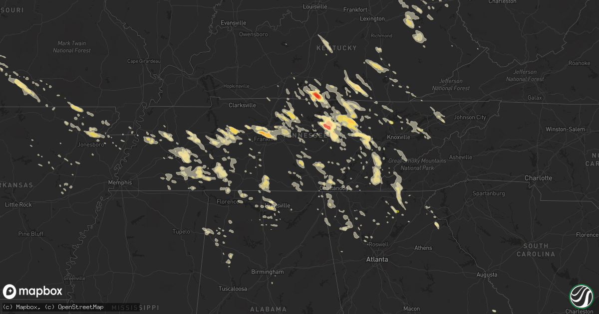
Hail Map in Tennessee on July 14, 2015
Get this storm
July 14 map
$229
one time, instant access
Download today. No call, no setup
Keep the $229
Bought the map and want the full workflow? Apply the entire $229 to a subscription within 7 days. None of it is wasted.
Every map, not just this one
This buys you this map. Subscription and you get every map we run, in the markets you choose from a few cities to whole states to nationwide. Plus real-time alerts the moment a storm fires.
Contact data
Name, contact info, occupancy, even credit band for addresses in the footprint. You go from where it hit to who to call.
Become the source they trust
Unlimited branding weather history reports on demand. You already have the documented answer ready for the property owner, and you are the one who showed up with it.
Property data and RoofTrace estimates
Pull up any address you have got, its value and the exact code rules for that jurisdiction, straight from One Click Code. Then RoofTrace estimates the squares, pitch, and roof value, priced the way you price.
Storm reports in Tennessee
Tennessee
| Date | Description |
|---|---|
| 07/14/20155:45 PM CDT | Spotter estimated 60 mph wind gust in southern wayne county. Report relayed by emergency manager. |
| 07/14/20155:45 PM CDT | Few trees down. |
| 07/14/20155:41 PM CDT | Several trees blown down near theta |
| 07/14/20155:33 PM CDT | Trees down on bealer road and dugout road. Large tree limb down on winfall road. |
| 07/14/20155:20 PM CDT | Trees down countywide. |
| 07/14/20155:15 PM CDT | Numerous trees down on houses in the limbo road area of hillsboro |
| 07/14/20155:15 PM CDT | Several trees down across hardin county with scattered power outages. |
| 07/14/20155:15 PM CDT | Trees snapped and uprooted on love lane road in hillsboro |
| 07/14/20155:15 PM CDT | Several trees down across the county with power outages. |
| 07/14/20155:05 PM CDT | Several trees down across hardeman county. |
| 07/14/20155:05 PM CDT | North wood drive memphis blocked by a tree which fell onto an suv. |
| 07/14/20155:05 PM CDT | Trees and power lines down. |
| 07/14/20155:00 PM CDT | Several trees down. |
| 07/14/20155:00 PM CDT | A few trees downed by thunderstorm winds. |
| 07/14/20155:00 PM CDT | Trees down. |
| 07/14/20155:00 PM CDT | Large tree down at riddle road and highway 55 intersection |
| 07/14/20154:58 PM CDT | Tree across hwy 18 and lowery road. |
| 07/14/20154:55 PM CDT | Trees and powerlines down on hwy 223 and womack lane. |
| 07/14/20154:55 PM CDT | Trees down. |
| 07/14/20154:55 PM CDT | Several trees down across chester county. |
| 07/14/20154:50 PM CDT | Fence along outdoor pool damaged by gusty wind estimated to be 65 mph. |
| 07/14/20154:50 PM CDT | Several trees down on automobiles. |
| 07/14/20154:45 PM CDT | Some trees down with scattered power outages. |
| 07/14/20154:40 PM CDT | Power lines down in whiteville. |
| 07/14/20154:30 PM CDT | Tree down on highland. |
| 07/14/20154:30 PM CDT | Tree down on a house on springdale street. |
| 07/14/20154:30 PM CDT | Tree blown down near lewisburg |
| 07/14/20154:25 PM CDT | Spotter measured 65 mph wind gust near collierville elementary. |
| 07/14/20154:25 PM CDT | Large tree uprooted...several other large limbs off of large trees near broadway n of bartlett. |
| 07/14/20154:21 PM CDT | Reports of trees down along old nashville hwy shelbyville road and short mountain at west green hill road |
| 07/14/20154:20 PM CDT | Several trees down around the county...large tree down on a house |
| 07/14/20154:15 PM CDT | Tree down on dogwood. |
| 07/14/20154:15 PM CDT | Trees down countywide. |
| 07/14/20154:15 PM CDT | Numerous trees down. |
| 07/14/20154:11 PM CDT | A local report indicates 60 MPH wind near SPRING CREEK |
| 07/14/20154:07 PM CDT | Numerous reports of multiple trees down in the west end of white county |
| 07/14/20154:05 PM CDT | Large tree blown down and blocked crisp springs road near crisp springs market |
| 07/14/20154:05 PM CDT | Tree on powerline at echols. |
| 07/14/20154:01 PM CDT | Trees down on power lines blocking road on will thompson road |
| 07/14/20154:00 PM CDT | Tree down on memphis/arlington road. |
| 07/14/20154:00 PM CDT | Trees down countywide. |
| 07/14/20154:00 PM CDT | Several trees down in haywood county. |
| 07/14/20154:00 PM CDT | Roof collapse at armory of tn national guard. |
| 07/14/20154:00 PM CDT | Several trees down across decatur county. |
| 07/14/20154:00 PM CDT | Some trees down across the county with power outages. |
| 07/14/20154:00 PM CDT | Roof blown off barn at west green hill road and campbell road |
| 07/14/20154:00 PM CDT | Reports of trees down along old nashville hwy shelbyville road and short mountain at west green hill road |
| 07/14/20154:00 PM CDT | Several trees across roadways in lauderdale county. |
| 07/14/20154:00 PM CDT | Roof blown off barn and numerous tree limbs down on pigeon hill road |
| 07/14/20154:00 PM CDT | Several trees down across dyer county with power outages. |
| 07/14/20154:00 PM CDT | Tree down on car on mynders ave. |
| 07/14/20153:55 PM CDT | Traffic signal down across the road at hwys 51 and 385. |
| 07/14/20153:54 PM CDT | Tree down on residence along lavergne lane |
| 07/14/20153:50 PM CDT | Trees down in the northern meigs county. |
| 07/14/20153:50 PM CDT | Tree down in covington. |
| 07/14/20153:50 PM CDT | 1 tree down. |
| 07/14/20153:50 PM CDT | Power lines down on highway 59. |
| 07/14/20153:50 PM CDT | Several trees down across tipton county. Hardest hit areas are in gilt edge...mumford and atoka. |
| 07/14/20153:45 PM CDT | A local report indicates 87 MPH wind near ATOKA |
| 07/14/20153:45 PM CDT | Widespread damage across tipton county with a few buildings in atoka receiving roof and structural damage. |
| 07/14/20153:45 PM CDT | Trees down along wears valley rd. |
| 07/14/20153:35 PM CDT | Golf ball size hail reported in derossett and bondecroft communities |
| 07/14/20153:34 PM CDT | Tree down in lake forrest estates area |
| 07/14/20153:30 PM CDT | Numerous trees down in the jefferson road area |
| 07/14/20153:30 PM CDT | 2 trees down in oakdale around 430 to 445 pm edt. |
| 07/14/20153:30 PM CDT | Large garage door blown off luna motorsports on highway 70 |
| 07/14/20153:25 PM CDT | Trees down on adcock cemetery road |
| 07/14/20153:25 PM CDT | Trees down countywide. |
| 07/14/20153:25 PM CDT | Tree blown down in home backyard in smyrna |
| 07/14/20153:25 PM CDT | Measured on home weather station |
| 07/14/20153:21 PM CDT | Three trees and two powerlines down among several streets. |
| 07/14/20153:18 PM CDT | Trees and power lines down at the woodmont blvd and valley brook road and along alabama ave in west nashville |
| 07/14/20153:15 PM CDT | Golf ball size hail reported on phifer mountain |
| 07/14/20153:10 PM CDT | Tree down on a church on 9th avenue south |
| 07/14/20153:08 PM CDT | Large tree down blocking robin road |
| 07/14/20153:07 PM CDT | Three to four homes damaged by uprooted large trees in the belle meade and forest hills areas. |
| 07/14/20153:07 PM CDT | Numerous trees and power lines down along the west end corridor in midtown nashville...including one tree on vanderbilt campus. |
| 07/14/20153:05 PM CDT | 3 trees blown down with one on a house at stones river road at lavergne lane |
| 07/14/20153:05 PM CDT | Power lines and trees down along double log cabin road |
| 07/14/20153:05 PM CDT | Power lines down with power outages near watertown |
| 07/14/20153:04 PM CDT | Tree down in the 300 block of bell meade blvd |
| 07/14/20153:04 PM CDT | Three homes and one business with damage. Numerous trees and power lines down around double springs road and hwy 70 |
| 07/14/20153:03 PM CDT | Widespread wind damage occurred across southwest nashville. Trees were blown down and blocked all westbound lanes of west end avenue near i-440. A tree was blown down a |
| 07/14/20153:00 PM CDT | Large tree blown down in buffalo |
| 07/14/20153:00 PM CDT | Power outages with dime size hail |
| 07/14/20153:00 PM CDT | Trees down in grant community |
| 07/14/20153:00 PM CDT | Multiple large trees down with shed and barn damaged around the hawkins crawford road and structural damage to home near prosperity drive |
| 07/14/20152:57 PM CDT | Trees and power lines down around the rocky valley road area |
| 07/14/20152:56 PM CDT | One inch plus hail reported in riverwalk subdivision in bellevue |
| 07/14/20152:55 PM CDT | Numerous trees and power lines down across the city including on heathrow blvd...stewart lane...and meadowlark lane. |
| 07/14/20152:53 PM CDT | Several large trees uprooted at turner farm |
| 07/14/20152:52 PM CDT | Tornado reported on the ground near north drive in double springs west of cookeville |
| 07/14/20152:51 PM CDT | Trees uprooted and power lines down near lebanon near coles ferry road and berea church road and academy road |
| 07/14/20152:50 PM CDT | Tree down on babelay rd. |
| 07/14/20152:50 PM CDT | Wkrn-tv photos show hail ranging from golf ball to large apple size fell in cookeville |
| 07/14/20152:50 PM CDT | A local report indicates 1.75 inch wind near HARRIMAN |
| 07/14/20152:49 PM CDT | Ef1 tornado touched down near double springs road and nashville highway then moved southeast. 12 to 15 homes and 1 business were damaged and numerous trees and power li |
| 07/14/20152:48 PM CDT | Large trees down on rawls creek road with roadway blocked |
| 07/14/20152:45 PM CDT | Quarter size hail reported in monterey |
| 07/14/20152:45 PM CDT | Photos from facebook show golf ball size hail in algood |
| 07/14/20152:43 PM CDT | Reported by cocorahs station cookeville 5.4 wnw |
| 07/14/20152:40 PM CDT | Photos show hail up to ping pong ball size fell in northeast wilson county |
| 07/14/20152:37 PM CDT | Trees reports down around the town of dickson |
| 07/14/20152:35 PM CDT | Tree blown down onto house in dickson |
| 07/14/20152:31 PM CDT | Golf ball sized hail reported by a tv met near grassland |
| 07/14/20152:30 PM CDT | Quarter sized hail reported near cookeville. |
| 07/14/20152:28 PM CDT | Quarter plus sized hail reported at percy warner park |
| 07/14/20152:25 PM CDT | Golf ball size hail reported near tennessee city |
| 07/14/20152:21 PM CDT | Golf ball sized hail reported at old natchez trace country club |
| 07/14/20152:21 PM CDT | Golf ball sized hail reported at old natchez trace country club |
| 07/14/20152:20 PM CDT | A local report indicates 1.00 inch wind near NORRIS |
| 07/14/20152:20 PM CDT | A local report indicates 1.00 inch wind near 5 N ROCKWOOD |
| 07/14/20152:18 PM CDT | Multiple power lines down along with power outages and trees down across overton county. |
| 07/14/20152:10 PM CDT | A local report indicates 1.00 inch wind near 5 SE JEFFERSON CITY |
| 07/14/20152:08 PM CDT | Photos show half dollar size fell in the dodson branch community |
| 07/14/20152:06 PM CDT | Quarter size hail reported downtown jamestown. |
| 07/14/20152:05 PM CDT | Trees down on highway 31e between gallatin and bethpage |
| 07/14/20152:00 PM CDT | Tree down in 2000 block of highway 52 |
| 07/14/20152:00 PM CDT | Deer lodge |
| 07/14/20151:57 PM CDT | Half dollar size hail reported in clarkrange and covering the ground |
| 07/14/20151:55 PM CDT | Reported by cocorahs station clarkrange 6.0 ne. Several dents to vehicles. |
| 07/14/20151:52 PM CDT | Golfball sized hail reported in grimsley |
| 07/14/20151:50 PM CDT | Several trees fell onto a cabin near east port marina with one falling through and destroying much of the building. Minor damage also occurred to the marina. |
| 07/14/20151:46 PM CDT | Ef1 tornado touched down on dale hollow lake south of byrdstown then moved se across far southern pickett county into western fentress county before lifting near boatla |
| 07/14/20151:40 PM CDT | Tree fell and blocked oak grove road near the cemetary |
| 07/14/20151:20 PM CDT | Several trees down in the flag pond area. |
| 07/14/20151:00 PM CDT | Couple trees down. |
| 07/14/201512:50 PM CDT | Tree down on baileyton rd. |
| 07/14/201510:05 AM CDT | Couple trees down. |
| 07/14/20159:30 AM CDT | 2 trees down in townsend. 1 large limb in the road. |
All States Impacted by Hail Map on July 14, 2015
Cities Impacted by Hail Map on July 14, 2015
- Morland, KS
- Clayton, KS
- Selden, KS
- Rapid City, SD
- Only, TN
- Hurricane Mills, TN
- Nunnelly, TN
- Waverly, TN
- McEwen, TN
- Centerville, TN
- Crossville, TN
- Crab Orchard, TN
- Oakdale, TN
- Rockwood, TN
- Harriman, TN
- Ruidoso Downs, NM
- Arcadia, NE
- Lebanon, TN
- Winner, SD
- Gamaliel, KY
- Tompkinsville, KY
- Hestand, KY
- Oconto, NE
- Valentine, NE
- Parshall, ND
- New Town, ND
- Sardis, TN
- Adamsville, TN
- Morris Chapel, TN
- Saltillo, TN
- Crump, TN
- Savannah, TN
- Stapleton, NE
- Bowersville, GA
- Canon, GA
- Eureka, KS
- Paragould, AR
- Velva, ND
- Minot, ND
- Surrey, ND
- Grafton, ND
- Hoople, ND
- Park River, ND
- Pleasanton, NE
- Beaver, OH
- Waverly, OH
- Sundance, WY
- Elkhart, KS
- Walsh, CO
- Campo, CO
- Nevada, MO
- Stockton, MO
- Jerico Springs, MO
- El Dorado Springs, MO
- Moundville, MO
- Deerfield, MO
- Sheldon, MO
- Fort Scott, KS
- Milo, MO
- Voltaire, ND
- Bryson City, NC
- Almond, NC
- Jackson, TN
- Quincy, KY
- Ord, NE
- Burwell, NE
- Lead, SD
- Teasdale, UT
- Arnold, NE
- Callaway, NE
- Yates Center, KS
- Elsmore, KS
- Virgil, KS
- Savonburg, KS
- Piqua, KS
- Humboldt, KS
- La Harpe, KS
- Iola, KS
- Toronto, KS
- Neosho Falls, KS
- Iron City, TN
- Florence, AL
- Holly, CO
- Bazine, KS
- Alexander, KS
- Hoxie, KS
- Stratton, CO
- Bethune, CO
- Lancaster, MN
- Morrisville, MO
- Marshfield, MO
- Half Way, MO
- Brighton, MO
- Bolivar, MO
- Pleasant Hope, MO
- Elkland, MO
- Fair Grove, MO
- Buffalo, MO
- Martin, GA
- Lavonia, GA
- Burlington, CO
- Huntsville, AL
- Huntland, TN
- Belvidere, TN
- Bel Air, MD
- Minneapolis, KS
- Bennington, KS
- Andrews, NC
- Marble, NC
- Briceville, TN
- Caryville, TN
- Johnson, KS
- Nolensville, TN
- Brentwood, TN
- Nashville, TN
- Franklin, TN
- Osceola, AR
- Park, KS
- Tallahassee, FL
- Crawfordville, FL
- Natoma, KS
- Ada, OH
- Lima, OH
- Fort Jennings, OH
- Columbus Grove, OH
- Hazelton, ND
- Gilbert, AZ
- Chandler, AZ
- Robbinsville, NC
- Chattanooga, TN
- Strafford, MO
- Chippewa Lake, OH
- Seville, OH
- Medina, OH
- Kennesaw, GA
- Garryowen, MT
- Page, NE
- Winnetoon, NE
- Orchard, NE
- Ezel, KY
- Vona, CO
- Petersburg, TN
- Pulaski, TN
- Frankewing, TN
- Dyersburg, TN
- Friendship, TN
- Glasco, KS
- Tullahoma, TN
- Clearville, PA
- Quinter, KS
- Woodston, KS
- Plainville, KS
- Alton, KS
- Cookeville, TN
- Williston, ND
- Bogue, KS
- Damar, KS
- Donalsonville, GA
- Dresden, KS
- Sparks, GA
- Summerville, GA
- Mentone, AL
- Lyerly, GA
- Menlo, GA
- Gaylesville, AL
- White Bluff, TN
- Hazlehurst, GA
- Palco, KS
- Hill City, KS
- Pall Mall, TN
- Jamestown, TN
- Byrdstown, TN
- Monroe, TN
- Albany, KY
- Monette, AR
- Black Oak, AR
- Idalia, CO
- Garden City, KS
- Madison, AL
- Lucasville, OH
- Argillite, KY
- West Portsmouth, OH
- West Union, OH
- Portsmouth, OH
- Lynx, OH
- Stout, OH
- South Portsmouth, KY
- Vanceburg, KY
- Olive Hill, KY
- Otway, OH
- Wheelersburg, OH
- Ironton, OH
- Friendship, OH
- Greenup, KY
- Worthington, KY
- Blue Creek, OH
- Franklin Furnace, OH
- Manchester, OH
- Grayson, KY
- Peebles, OH
- Garrison, KY
- South Shore, KY
- Maxwell, NE
- Anselmo, NE
- Cheyenne Wells, CO
- Pottersville, MO
- Drury, MO
- Dora, MO
- Vanzant, MO
- West Plains, MO
- Elyria, NE
- Murphy, NC
- Ness City, KS
- Burkesville, KY
- Duff, TN
- La Follette, TN
- Pioneer, TN
- Newcomb, TN
- Hoskins, NE
- Lobelville, TN
- Holladay, TN
- Ripley, WV
- Trenton, TN
- Litchfield, NE
- Loup City, NE
- Ardmore, TN
- Dellrose, TN
- Seymour, MO
- Dahlonega, GA
- Suches, GA
- Campton, KY
- Rockbridge, OH
- Topton, NC
- Walnut Ridge, AR
- Pocahontas, AR
- Sparta, TN
- Jefferson City, TN
- New Market, TN
- Dandridge, TN
- Burbank, OH
- Lodi, OH
- West Salem, OH
- Homerville, OH
- Jackson, OH
- Bunker Hill, KS
- Dorrance, KS
- Springfield, CO
- Rogersville, TN
- Whitesburg, TN
- Waynesboro, TN
- Dadeville, MO
- Dickson, TN
- Hartsville, TN
- Gallatin, TN
- Castalian Springs, TN
- Bethpage, TN
- Harvest, AL
- Jonesboro, AR
- Beech Grove, AR
- Brookland, AR
- Bono, AR
- Register, GA
- Le Roy, WV
- Baxter, TN
- Monterey, TN
- Bloomington Springs, TN
- Pompano Beach, FL
- Deerfield Beach, FL
- Holcomb, KS
- Dola, OH
- Kenton, OH
- Epping, ND
- Emporia, KS
- Farner, TN
- Madisonville, TN
- Sweetwater, TN
- Englewood, TN
- Tellico Plains, TN
- Reliance, TN
- Turtletown, TN
- Vonore, TN
- Woodbine, KY
- Riddleton, TN
- Dixon Springs, TN
- Letart, WV
- Leon, WV
- Glasgow, KY
- Gainesboro, TN
- Dalhart, TX
- Piketon, OH
- Manila, AR
- Tescott, KS
- Clarkrange, TN
- Ethridge, TN
- Rogersville, AL
- Page, ND
- Hope, ND
- Monticello, KY
- Carlisle, KY
- Owingsville, KY
- Flemingsburg, KY
- Sharpsburg, KY
- Hillsboro, KY
- Moorefield, KY
- Ewing, KY
- Keyes, OK
- Boise City, OK
- Humboldt, TN
- Evensville, TN
- Gridley, KS
- Madison, KS
- Livingston, TN
- Fairburn, SD
- Falkville, AL
- Adairsville, GA
- Stanton, NE
- Athens, AL
- Front Royal, VA
- Imboden, AR
- Ravenden, AR
- Hazard, NE
- Pierce, NE
- Norfolk, NE
- Chickamauga, GA
- Trenton, GA
- La Fayette, GA
- Rising Fawn, GA
- Lookout Mountain, GA
- Wildwood, GA
- Wakeeney, KS
- Collyer, KS
- Comstock, NE
- Keystone, SD
- Deadwood, SD
- Ellis, KS
- Lakeland, GA
- Ray City, GA
- Leitchfield, KY
- Grenora, ND
- Sugar Tree, TN
- Camden, TN
- Lamar, CO
- Hammonton, NJ
- Grimsley, TN
- Deer Lodge, TN
- Willow Springs, MO
- Pomona, MO
- McRae Helena, GA
- Mammoth Spring, AR
- Minto, ND
- Forest River, ND
- Gove, KS
- Minford, OH
- Leachville, AR
- Trion, GA
- Maynard, AR
- Couch, MO
- Gatewood, MO
- Warm Springs, AR
- Hill City, SD
- Columbia, TN
- Athens, OH
- Clayton, NM
- Quincy, FL
- Mount Juliet, TN
- Center, ND
- Williamstown, WV
- Fleming, OH
- Marietta, OH
- New Holland, OH
- Chillicothe, OH
- Frankfort, OH
- Ransom, KS
- Utica, KS
- Philadelphia, TN
- Cairo, OH
- Rush Center, KS
- Walnut, MS
- Black Rock, AR
- Saint Xavier, MT
- Foxhome, MN
- Henderson, TN
- Bethel Springs, TN
- Finger, TN
- Willard, MO
- Franklin, NC
- Gassaway, WV
- Exchange, WV
- Helenwood, TN
- Balfour, ND
- Newcastle, WY
- Leoti, KS
- Deerfield, KS
- Marienthal, KS
- Scott City, KS
- Boynton Beach, FL
- Hamilton, KS
- Vincent, OH
- Harrison, TN
- Hixson, TN
- Manchester, TN
- Alma, NE
- Republican City, NE
- Hohenwald, TN
- Lawrenceburg, TN
- Gallina, NM
- Rocky Top, TN
- Nelsonville, OH
- Logan, OH
- Haydenville, OH
- Union Furnace, OH
- Miracle, KY
- Pineville, KY
- Middlesboro, KY
- Beloit, KS
- Tipton, KS
- Hunter, KS
- Tyrone, PA
- Warriors Mark, PA
- Rome, GA
- Kingston, GA
- Blytheville, AR
- Manhattan, KS
- Swainsboro, GA
- Soperton, GA
- Lyons, GA
- Blackshear, GA
- Linden, TN
- Collinwood, TN
- Westpoint, TN
- Lenora, KS
- Norton, KS
- Dublin, GA
- Mays Landing, NJ
- Egg Harbor Township, NJ
- Holland, KY
- Scottsville, KY
- Lafayette, TN
- Lodge Grass, MT
- Hasty, CO
- Rickman, TN
- Allred, TN
- Crawford, TN
- Alpine, TN
- Dayton, TN
- Rienzi, MS
- Ruckersville, VA
- Stanardsville, VA
- Madison, VA
- Hood, VA
- Upton, WY
- Abiquiu, NM
- Bulls Gap, TN
- Mosheim, TN
- Greeneville, TN
- Osborne, KS
- Bidwell, OH
- Gallipolis, OH
- Gallipolis Ferry, WV
- Bald Knob, AR
- Clifton, TN
- Kingston, TN
- Hays, KS
- Somerset, KY
- Sabina, OH
- Washington Court House, OH
- Morrison, TN
- Bradyville, TN
- Newport, AR
- McCrory, AR
- Millville, NJ
- Cedar Grove, TN
- Huntingdon, TN
- Wilder, TN
- Mountain View, AR
- Wilson, KS
- Ellsworth, KS
- Broken Bow, NE
- Ball Ground, GA
- Jasper, GA
- Gillette, WY
- Creston, OH
- Laceys Spring, AL
- Sylvania, GA
- Millen, GA
- Rocky Ford, GA
- Clay Center, KS
- Heaters, WV
- Napier, WV
- Pennsylvania Furnace, PA
- Moss, TN
- Eubank, KY
- Mount Vernon, KY
- London, KY
- Wilmington, OH
- Leesburg, OH
- New Vienna, OH
- Cincinnati, OH
- Ft Mitchell, KY
- Covington, KY
- Erlanger, KY
- Florence, KY
- Hebron, KY
- Pegram, TN
- Thorn Hill, TN
- Mooresburg, TN
- Sneedville, TN
- Almond, NY
- Arkport, NY
- Hayesville, NC
- Brasstown, NC
- Milan, TN
- Medina, TN
- Perham, MN
- Blanchester, OH
- Fayetteville, OH
- Benton, TN
- Delano, TN
- Cullman, AL
- Bascom, FL
- Martinsville, OH
- Bells, TN
- Creighton, NE
- Blairsville, GA
- Mason City, NE
- Emerson, KY
- Young, AZ
- Stockport, OH
- Waterford, OH
- Lakeside, NE
- Vina, AL
- Oak Hill, OH
- South Webster, OH
- Alexander, ND
- Watford City, ND
- Tishomingo, MS
- Bristolville, OH
- North Bloomfield, OH
- Cortland, OH
- Fairmount, ND
- Campbell, MN
- Tintah, MN
- Bolivar, TN
- Hickory Valley, TN
- Catharine, KS
- Lascassas, TN
- Murfreesboro, TN
- La Vergne, TN
- Smyrna, TN
- Westport, TN
- Trezevant, TN
- Yuma, TN
- McKenzie, TN
- Buena Vista, TN
- Hanceville, AL
- Crane Hill, AL
- Bremen, AL
- South Solon, OH
- Bloomingburg, OH
- Mount Sterling, OH
- London, OH
- Broxton, GA
- Beersheba Springs, TN
- Altamont, TN
- Harrod, OH
- Tanner, AL
- Mansfield, MO
- Hitchins, KY
- Denton, KY
- Tremont, MS
- Hamilton, AL
- Anderson, AL
- Lexington, AL
- Rector, AR
- Marmaduke, AR
- Delray Beach, FL
- Transfer, PA
- Greenville, PA
- Fredonia, PA
- McClave, CO
- Townsend, TN
- Cord, AR
- Newark, AR
- Antioch, TN
- New Haven, KY
- Raywick, KY
- New Hope, KY
- Campbellsville, KY
- Charleston, WV
- Georgetown, OH
- Hamersville, OH
- Prospect, TN
- Ardmore, AL
- Taft, TN
- Fayetteville, TN
- Pritchett, CO
- Luttrell, TN
- Maynardville, TN
- Powder Springs, TN
- Hillsboro, OH
- Sunbright, TN
- Robbins, TN
- Frederick, MD
- Middletown, MD
- Delphos, KS
- Huron, TN
- Scotts Hill, TN
- Lexington, TN
- Reagan, TN
- Lula, GA
- Murrayville, GA
- Cleveland, GA
- Mountain View, MO
- Milford Center, OH
- North Lewisburg, OH
- Pangburn, AR
- Lake City, FL
- Hermosa, SD
- Tohatchi, NM
- Eustis, FL
- Spencer, TN
- Lake City, AR
- Young Harris, GA
- Warne, NC
- Fair Play, MO
- Aldrich, MO
- Rutland, OH
- Mason, WV
- West Columbia, WV
- Pomeroy, OH
- Racine, OH
- Hartford, WV
- Syracuse, OH
- Elkton, VA
- Dunlap, TN
- Strandquist, MN
- Red Boiling Springs, TN
- Mount Hermon, KY
- Celina, TN
- Fountain Run, KY
- Paradise, KS
- Waldo, KS
- Ten Mile, TN
- Augusta, AR
- Chelsea, AL
- Brush Creek, TN
- Liberty, TN
- Alexandria, TN
- Watertown, TN
- Luray, TN
- Beech Bluff, TN
- Mesa, AZ
- Wellington, FL
- West Palm Beach, FL
- Blaine, TN
- Strawberry Plains, TN
- Newport, TN
- Rutledge, TN
- Ravenswood, WV
- Millwood, WV
- Mountain Grove, MO
- Norwood, MO
- Jacksonville, GA
- New Marshfield, OH
- Albany, OH
- Norwich, ND
- Granville, ND
- Karlsruhe, ND
- Whitwell, TN
- Weskan, KS
- Culleoka, TN
- Starkweather, ND
- Nancy, KY
- Stearns, KY
- Jamestown, KY
- Hackleburg, AL
- Alpha, KY
- Ansley, NE
- Mcminnville, TN
- Woodbury, TN
- Nahunta, GA
- Spring City, TN
- Decatur, TN
- Calvin, KY
- New Knoxville, OH
- Wapakoneta, OH
- Toney, AL
- Westminster, SC
- Toccoa, GA
- Sharps Chapel, TN
- Hornell, NY
- Moshannon, PA
- Thornville, OH
- Heath, OH
- Simpson, KS
- Means, KY
- Frenchburg, KY
- Salt Lick, KY
- Olympia, KY
- Langsville, OH
- Ty Ty, GA
- Sumner, GA
- Jennings, KS
- Guin, AL
- Alamo, GA
- Claflin, KS
- Hoisington, KS
- Phelps, KY
- Thayer, MO
- Koshkonong, MO
- Russell Springs, KY
- Newfolden, MN
- Cotton Plant, AR
- McCracken, KS
- Clinton, TN
- Andersonville, TN
- Norris, TN
- Ray, OH
- Sequatchie, TN
- Jasper, TN
- Guild, TN
- Signal Mountain, TN
- Owyhee, NV
- Mountain City, NV
- Kingston Springs, TN
- Charlotte, TN
- Woodstock, GA
- Acworth, GA
- New York Mills, MN
- Frazee, MN
- Athens, TN
- Riceville, TN
- Calhoun, GA
- Armuchee, GA
- Finley, TN
- White, GA
- Portland, TN
- Goodlettsville, TN
- Carthage, TN
- Westmoreland, TN
- Hendersonville, TN
- Gordonsville, TN
- Fortuna, ND
- Douglas, GA
- Concord, VA
- Lynchburg, VA
- Middletown, VA
- Capon Bridge, WV
- Augusta, WV
- Stephens City, VA
- High View, WV
- Delray, WV
- Wardensville, WV
- Strasburg, VA
- Star Tannery, VA
- Rio, WV
- Yellow Spring, WV
- Winchester, VA
- Middleton, TN
- Saulsbury, TN
- Lincoln, KS
- Nemo, SD
- Rushsylvania, OH
- Ridgeway, OH
- Uniontown, KS
- Redfield, KS
- Plainville, GA
- Mount Berry, GA
- Tazewell, TN
- Rose Hill, VA
- Ewing, VA
- Beeler, KS
- Syracuse, KS
- Cartersville, GA
- Sewell, NJ
- Blackwood, NJ
- Sicklerville, NJ
- Valhermoso Springs, AL
- Somerville, AL
- Smithville, TN
- Penokee, KS
- Merna, NE
- Arrington, VA
- Shipman, VA
- Brodhead, KY
- Berea, KY
- Woodburn, KY
- Artemas, PA
- Halls, TN
- Ava, MO
- Russellville, AL
- Phil Campbell, AL
- Riley, KS
- Osmond, NE
- Plainview, NE
- Denhoff, ND
- Lafe, AR
- Bronson, KS
- Flintstone, MD
- Conway, MO
- Niangua, MO
- Iuka, MS
- Burnsville, MS
- Dyer, TN
- Stoutsville, OH
- Walnut Grove, MO
- Carbon Hill, AL
- Eldridge, AL
- Berry, AL
- Bankston, AL
- Hermitage, TN
- Milton, TN
- Auburntown, TN
- Hurdsfield, ND
- Austin, IN
- Crothersville, IN
- Moran, KS
- Hazel Green, KY
- Vancleve, KY
- Fayette, AL
- Glennville, GA
- Walker, KS
- Lucas, KS
- Russell, KS
- Luray, KS
- Victoria, KS
- Gorham, KS
- Etoile, KY
- Hilham, TN
- Minster, OH
- Michie, TN
- Winchester, TN
- Decherd, TN
- Estill Springs, TN
- Lynchburg, TN
- Romney, WV
- Purgitsville, WV
- Willow Wood, OH
- Kitts Hill, OH
- Gates, TN
- Flatwoods, KY
- Russell, KY
- Kenton, TN
- Rutherford, TN
- Birch Tree, MO
- Biggers, AR
- Town Creek, AL
- Karthaus, PA
- Kit Carson, CO
- Pikeville, TN
- Woodville, AL
- Downs, KS
- Ooltewah, TN
- Parsons, TN
- Pedro, OH
- Chagrin Falls, OH
- Jeffersonville, OH
- Jamestown, OH
- Springfield, MO
- Burlington, KS
- Le Roy, KS
- Lenoir City, TN
- Loudon, TN
- Trumann, AR
- Harrisburg, AR
- Clifton, KS
- Morganville, KS
- Primm Springs, TN
- Bon Aqua, TN
- Fairview, TN
- Palmer, TN
- Buchanan, GA
- Wallace, NE
- Kanorado, KS
- Smithville, WV
- Barnard, KS
- Given, WV
- Evans, WV
- Greenfield, OH
- Tryon, NE
- Sterling, OH
- Smithville, OH
- Bradford, AR
- Strunk, KY
- Paw Paw, WV
- Great Cacapon, WV
- Otto, NC
- Sautee Nacoochee, GA
- Helen, GA
- Hope, KY
- Williamsport, OH
- Clarksburg, OH
- Danville, AL
- Petroleum, WV
- Waverly, WV
- Saint Marys, WV
- Walker, WV
- Gordon, AL
- Malone, FL
- Hartselle, AL
- Decatur, AL
- Ewing, NE
- Hillsboro, TN
- Boyce, VA
- Morehead, KY
- Jeffersonville, KY
- Mount Sterling, KY
- Clewiston, FL
- Bowling Green, KY
- Green River, UT
- Winfield, TN
- Elfrida, AZ
- Moorcroft, WY
- Bear Creek, AL
- Haleyville, AL
- Lancing, TN
- Birmingham, AL
- Gruetli Laager, TN
- Coalmont, TN
- Delaplane, VA
- Markham, VA
- Ohio City, OH
- Wakefield, KS
- Clyde, KS
- Concordia, KS
- Arrington, TN
- Ideal, SD
- Cleveland, TN
- Lynchburg, OH
- Midland, OH
- Mullica Hill, NJ
- Monroeville, NJ
- Hornsby, TN
- Olivehill, TN
- Selmer, TN
- Enville, TN
- Bath Springs, TN
- Lutts, TN
- Milledgeville, TN
- Sonoita, AZ
- Jackson, KY
- South Salem, OH
- Clarksville, OH
- Harveysburg, OH
- Waynesville, OH
- Thedford, NE
- Reno, OH
- Glen Elder, KS
- Datto, AR
- Corning, AR
- Roseglen, ND
- Flatwoods, WV
- Union Grove, AL
- Kingston, OH
- Circleville, OH
- Cheshire, OH
- Point Pleasant, WV
- Hartville, MO
- Grovespring, MO
- Denmark, TN
- Orlando, KY
- Summerton, SC
- Williamstown, NJ
- Newfield, NJ
- Guys, TN
- Crab Orchard, KY
- Waynesburg, KY
- Alvaton, KY
- Lake Worth, FL
- Bainbridge, OH
- Williamsport, TN
- Santa Fe, TN
- Bryant, AL
- Sparta, KY
- Sanders, KY
- New Liberty, KY
- Flat Lick, KY
- Walker, KY
- Sandy Hook, KY
- Wartburg, TN
- Brilliant, AL
- Williamsburg, OH
- Mount Orab, OH
- Goshen, OH
- Sardinia, OH
- Otis, KS
- Paint Lick, KY
- Sylvan Grove, KS
- Pataskala, OH
- Granville, OH
- Blacklick, OH
- Johnstown, OH
- Alexandria, OH
- New Albany, OH
- Columbus, OH
- Westerville, OH
- Stockton, KS
- Denton, GA
- Erie, KS
- Claxton, GA
- Oil Trough, AR
- Rocklake, ND
- Clearfield, KY
- Whitleyville, TN
- Summer Shade, KY
- Austin, KY
- Walling, TN
- Hebron, OH
- Soddy Daisy, TN
- Sale Creek, TN
- Graysville, TN
- Loxahatchee, FL
- Huntsville, TN
- East Bernstadt, KY
- Menoken, ND
- Pinson, TN
- Oakfield, TN
- Slanesville, WV
- Bloomery, WV
- Eskridge, KS
- Beaumont, KY
- Edmonton, KY
- Greenback, TN
- Woodstown, NJ
- Breckenridge, MN
- Old Fort, TN
- Maineville, OH
- West Chester, OH
- Mason, OH
- Middletown, OH
- Dawsonville, GA
- Floral, AR
- Saint Francis, KS
- Hiawassee, GA
- New Carlisle, OH
- Tremont City, OH
- Springfield, OH
- Casstown, OH
- Saint Paris, OH
- Christiansburg, OH
- Urbana, OH
- Conover, OH
- Troy, OH
- La Crosse, KS
- Alma, KS
- Tallassee, TN
- Maryville, TN
- Walland, TN
- Fulton, MS
- Springfield, TN
- Orlinda, TN
- Adairville, KY
- Wahpeton, ND
- Brady, NE
- Van Wert, OH
- Convoy, OH
- Henagar, AL
- Lebanon, OH
- Monroe, OH
- Alamo, TN
- Fisher, AR
- Tracy City, TN
- Chambers, NE
- Powhatan, AR
- McDonald, TN
- Apison, TN
- Yulee, FL
- Cypress Inn, TN
- Knoxville, TN
- Corryton, TN
- Boston, KY
- Millersburg, OH
- Sugarcreek, OH
- Decaturville, TN
- Winchester, OH
- Adel, GA
- Humansville, MO
- West Farmington, OH
- Solomon, KS
- Chatsworth, GA
- Matfield Green, KS
- Arapahoe, CO
- Goodrich, ND
- Rydal, GA
- Fairmount, GA
- Morrow, OH
- South Lebanon, OH
- Middletown, DE
- Elkton, MD
- Chesapeake City, MD
- Newark, DE
- Bear, DE
- Peace Valley, MO
- Muscle Shoals, AL
- Killen, AL
- Chanute, KS
- Wellston, OH
- Hamden, OH
- Vinton, OH
- Kim, CO
- La Junta, CO
- Lynnville, TN
- Wooster, OH
- Niota, TN
- Newbern, TN
- Buffalo Valley, TN
- Lancaster, TN
- Alton, MO
- Ripley, OH
- Corbin, KY
- Gray, KY
- Steele, MO
- Burnside, KY
- Bronston, KY
- Whitley City, KY
- Nashville, GA
- Abilene, KS
- Sheridan, WY
- Appomattox, VA
- Spout Spring, VA
- Canton, GA
- Valley Head, AL
- Guysville, OH
- Pleasant Hill, TN
- Allons, TN
- Granville, TN
- Mountain Rest, SC
- Long Creek, SC
- Rochelle, VA
- Aroda, VA
- Radiant, VA
- Orange, VA
- Kenna, WV
- Egg Harbor City, NJ
- Darden, TN
- Wildersville, TN
- Smiths Grove, KY
- Oakland, KY
- Loretto, KY
- Saint Francis, KY
- Birchwood, TN
- West Liberty, KY
- Belpre, OH
- Stuart, FL
- Hobe Sound, FL
- Junction City, KS
- Chapman, KS
- Resaca, GA
- Barbourville, KY
- Gregory, SD
- Dallas, SD
- Pilger, NE
- Hunter, AR
- Burns, TN
- New Johnsonville, TN
- Lyles, TN
- Winfield, AL
- Neligh, NE
- Manter, KS
- Glen, MS
- Beechgrove, TN
- Loveland, OH
- Pleasant Plain, OH
- Mount Vernon, GA
- Silver Point, TN
- Londonderry, OH
- Richmond Dale, OH
- Leonardville, KS
- Green, KS
- Dunnegan, MO
- Fordland, MO
- Rogersville, MO
- Columbia, KY
- South Pittsburg, TN
- Elkmont, AL
- Etowah, TN
- Saint Marys, OH
- Martin, KY
- Drasco, AR
- Concord, AR
- Egeland, ND
- Morganton, GA
- Blue Ridge, GA
- Portis, KS
- Ogallah, KS
- Pfeifer, KS
- Cedar Point, KS
- Sandy Ridge, PA
- Philipsburg, PA
- Ranger, GA
- Baileyton, AL
- Eva, AL
- Joppa, AL
- Aniwa, WI
- Antigo, WI


