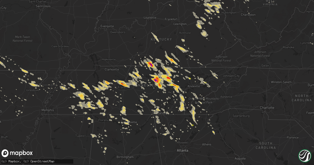
Hail Map on July 14, 2015
Get this storm
July 14 map
$229
one time, instant access
Download today. No call, no setup
Keep the $229
Bought the map and want the full workflow? Apply the entire $229 to a subscription within 7 days. None of it is wasted.
Every map, not just this one
This buys you this map. Subscription and you get every map we run, in the markets you choose from a few cities to whole states to nationwide. Plus real-time alerts the moment a storm fires.
Contact data
Name, contact info, occupancy, even credit band for addresses in the footprint. You go from where it hit to who to call.
Become the source they trust
Unlimited branding weather history reports on demand. You already have the documented answer ready for the property owner, and you are the one who showed up with it.
Property data and RoofTrace estimates
Pull up any address you have got, its value and the exact code rules for that jurisdiction, straight from One Click Code. Then RoofTrace estimates the squares, pitch, and roof value, priced the way you price.
States Impacted by Hail Map on July 14, 2015
Storm reports
Minnesota
| Date | Description |
|---|---|
| 07/14/20156:45 PM CDT | Time estimated from radar. Shingle damage and trees snapped in perham. Relayed via social media. |
| 07/14/20155:25 PM CDT | Large hail...strong winds and very heavy rain. |
Montana
| Date | Description |
|---|---|
| 07/14/20156:07 PM CDT | A local report indicates 70 MPH wind near ST XAVIER |
| 07/13/20157:36 PM CDT | Strong winds and heavy rain for 30 minutes. |
| 07/13/20157:13 PM CDT | A local report indicates 70 MPH wind near 5 SSW BUSBY |
Pennsylvania
| Date | Description |
|---|---|
| 07/14/20153:56 PM CDT | 1 inch hail mm 54 on i99 |
| 07/14/20152:36 PM CDT | Tree down on power lines on folk road near fredonia |
| 07/14/20152:30 PM CDT | Trees down near kane |
| 07/14/20151:50 PM CDT | Multiple trees down sr 321 south of bliss hill |
New York
| Date | Description |
|---|---|
| 07/14/20155:12 PM CDT | Trees down. |
| 07/14/20155:08 PM CDT | Trees down. |
| 07/14/20155:04 PM CDT | 10 inch dia. Tree across road. |
| 07/14/20154:40 PM CDT | Tree down at otsego lake. Radar estimated time. |
| 07/14/20154:40 PM CDT | Tree down. |
| 07/14/20154:39 PM CDT | Trees down. |
| 07/14/20154:25 PM CDT | Tree down. Radar estimated time. |
| 07/14/20154:20 PM CDT | Trees down. |
| 07/14/20154:04 PM CDT | Trees blocking both lanes of i-86 at mile post 132. |
| 07/14/20154:01 PM CDT | Trees down. |
| 07/14/20154:00 PM CDT | Trees down. |
| 07/14/20153:55 PM CDT | Trees down. One blocking the road. |
| 07/14/20153:31 PM CDT | Trees and wires down |
| 07/14/20153:21 PM CDT | Trees and wires down |
| 07/14/20153:20 PM CDT | Storm survey found dozens of downed trees oriented in the same direction from the eastern end of perch road east-northeast to near the intersection of county road 2a an |
| 07/14/20153:17 PM CDT | Damage along i-86 and surrounding area with many trees down. Trained spotter reported funnel cloud. |
| 07/14/20153:15 PM CDT | Storm survey found wooden truss frame of barn under construction flattened by straight line winds along county road 2a. |
| 07/14/20152:50 PM CDT | Trees and wires down |
| 07/14/20152:26 PM CDT | Trees and wires down |
Arkansas
| Date | Description |
|---|---|
| 07/14/20153:37 PM CDT | Spotter estimates wind between 60 and 70 mph in wilson. |
| 07/14/20153:30 PM CDT | Overturned 18 wheeler on i55 at mile marker 62. |
| 07/14/20153:30 PM CDT | Tree on a house in monette via photo submitted to social media. |
| 07/14/20153:23 PM CDT | Power lines down on west state street. |
| 07/14/20153:14 PM CDT | Est winds near 68 mph with power outage in trumann. |
| 07/14/20153:11 PM CDT | Power lines down across hwy 63 west of jonesboro. |
| 07/14/20153:06 PM CDT | Significant wind damage in brookland. Numerous trees down and a shed destroyed. |
| 07/14/20153:05 PM CDT | Tree blocking a street in paragould. |
| 07/14/20153:02 PM CDT | 18 wheeler blown over at exxon truck stop 3109 commerce. |
| 07/14/20153:01 PM CDT | Ham operator measured 81 mph wind gust. |
| 07/14/20153:00 PM CDT | Roof blown off local grocery store. |
| 07/14/20153:00 PM CDT | Canopy blown off paragould high school. |
| 07/14/20152:55 PM CDT | Tree on a house. |
| 07/14/20152:55 PM CDT | Tree crushed a shed on chadwick drive. |
| 07/14/20152:53 PM CDT | Winds estimated to be greater than 60 mph. |
| 07/14/20152:50 PM CDT | A local report indicates 59 MPH wind near JONESBORO |
| 07/14/20152:41 PM CDT | 57 knot wind reported at walnut ridge airport. |
| 07/14/20152:35 PM CDT | Several trees down across randolph county. Winds estimated to be between 60 and 70 mph. |
| 07/14/20152:23 PM CDT | Tree across the road. |
| 07/14/20152:23 PM CDT | Tree fell on a house. |
| 07/14/20151:48 PM CDT | A tree fell across three cars in the mammoth spring state park area. No injuries were reported |
Michigan
| Date | Description |
|---|---|
| 07/14/201511:50 AM CDT | Spotter reported that a large tree limb about 6 inches in diameter had been snapped and landed on the roof of a house. Time estimated by radar. |
Missouri
| Date | Description |
|---|---|
| 07/14/20153:28 PM CDT | Trees down in cardwell. |
| 07/14/20151:40 PM CDT | Report of powerlines and trees down. Most main roads are blocked by trees or powerlines. Also received twitter public report of an estimated 60-70 mph wind. |
| 07/14/20151:08 PM CDT | Trees and limbs down up to eight inches in diameter. |
| 07/14/201512:58 PM CDT | Trees down across road on old rolla road. |
| 07/14/201512:42 PM CDT | A local report indicates 58 MPH wind near CABOOL |
| 07/14/201512:15 PM CDT | Mshp reports part of a roof blown into traffic near the 107 mile marker on i-44. Traffic blocked. |
| 07/14/201512:15 PM CDT | Damage to a barn. Large limbs down. |
| 07/14/201512:00 PM CDT | Large 8 inch diameterr limb down on highway 125. |
| 07/14/201511:58 AM CDT | Small 1 inch limbs down from hwy 123 to fr 42 and from fr 91 to fr 79 in northern greene county. Time estimated based on radar. |
| 07/14/201511:51 AM CDT | Numerous large trees down. Time based on radar estimate. |
| 07/14/201511:51 AM CDT | Trailer park on plank school road had some mobile homes that slid off of their piers. |
| 07/14/201511:45 AM CDT | Limbs to 6 inches in diameter down on banning street in town. |
| 07/14/201511:43 AM CDT | Road signs and trees down. |
| 07/14/201511:41 AM CDT | North pitts st had tree uprooted. Electric out along with stop lights. Also trees down on washington street. |
| 07/14/201511:41 AM CDT | Over 100 trees uprooted or snapped off. Power poles snapped halfway up. Extensive power lines down. Dozens of trees on homes. Some shingle damage and roof peelings. Sev |
| 07/14/201511:41 AM CDT | Tree limbs down and a large metal swing set blown over. |
| 07/14/201511:31 AM CDT | A local report indicates 1.00 inch wind near 4 ENE MORRISVILLE |
| 07/14/201511:31 AM CDT | A few trees reported down near farm road 34 and highway 13. |
| 07/14/201511:25 AM CDT | 10 inch diameter tree branch snapped 1 mile south of fair grove along highway 125. Time estimated based on radar. |
| 07/14/201511:10 AM CDT | Tree down at teh intersection of farmer and cherry streets in town. Time estimated from radar. |
| 07/14/201511:10 AM CDT | Nickle hail also reported with the wind gust. |
| 07/14/201511:05 AM CDT | Power lines and 5 inch diameter limb down along buffalo road in town. |
| 07/14/201511:03 AM CDT | Tree damage reported near the intersections of county roads s170 and e530. |
| 07/14/201510:50 AM CDT | Two inch diameter limbs down. |
| 07/14/201510:49 AM CDT | Roof damage to a barn. Picture relayed on social media from local tv station. |
Florida
| Date | Description |
|---|---|
| 07/14/20152:57 PM CDT | Large tree limb down. Report received via social media. |
| 07/14/20152:53 PM CDT | Quater hail reported and tree limbs down via palm beach county sheriffs office |
| 07/14/20152:51 PM CDT | Quater size hail reported on boynton beach blvd between military trail and jog rd. Relayed by local media. |
| 07/14/20152:40 PM CDT | Large palm tree down in deerfield. Time estimated from radar. Viewer by way of social media. |
| 07/14/20152:40 PM CDT | Large palm tree down in deerfield near south military trail. Time estimated from radar. Viewer by way of social media. |
| 07/14/20152:25 PM CDT | Four large branches from tree damaged trunk of a car. Other tree damage also in the area. Pea sized hail too. |
Kentucky
| Date | Description |
|---|---|
| 07/14/20156:55 PM CDT | A tree was blown down. |
| 07/14/20156:55 PM CDT | A tree was blown down onto the roadway. |
| 07/14/20156:53 PM CDT | A tree was blown down onto riley br rd. |
| 07/14/20156:50 PM CDT | Trees were blown down. |
| 07/14/20156:50 PM CDT | A tree was blown down on houston road. |
| 07/14/20156:50 PM CDT | A tree was blown down onto ky highway 899 |
| 07/14/20156:48 PM CDT | Some power lines down. |
| 07/14/20156:47 PM CDT | Trees and power lines down. |
| 07/14/20156:45 PM CDT | Trees down across prestonsburg and floyd county...including mays branch...corn fork...and a tree which fell on and damaged a fire truck on jenny wiley road. |
| 07/14/20156:42 PM CDT | Four trees down. |
| 07/14/20156:40 PM CDT | Large tree limbs down. |
| 07/14/20156:40 PM CDT | Trees were blown down along marrowbone ck rd. |
| 07/14/20156:40 PM CDT | A tree was blown down. |
| 07/14/20156:35 PM CDT | A tree was blown down on curt road. |
| 07/14/20156:34 PM CDT | Trees and power lines down. |
| 07/14/20156:33 PM CDT | Trees were blown down. |
| 07/14/20156:30 PM CDT | A tree was blown down. |
| 07/14/20156:30 PM CDT | Trees were blown down. |
| 07/14/20156:28 PM CDT | Trees were blown down. |
| 07/14/20156:28 PM CDT | Trees and power pole down. |
| 07/14/20156:25 PM CDT | Trees were blown down on ky highway 476. |
| 07/14/20156:25 PM CDT | Tree down. |
| 07/14/20156:22 PM CDT | 10 inch diameter tree across roadway. |
| 07/14/20156:21 PM CDT | Hwy 89 road closed due to tree blocking both lanes. |
| 07/14/20156:20 PM CDT | Trees were blown down. |
| 07/14/20156:20 PM CDT | Trees were blown down. |
| 07/14/20156:10 PM CDT | Trees were blown down. |
| 07/14/20156:10 PM CDT | Numerous trees and powerlines down. |
| 07/14/20156:10 PM CDT | Trees were blown down. |
| 07/14/20156:05 PM CDT | Tree fell on house. |
| 07/14/20156:00 PM CDT | A large tree was blown down. |
| 07/14/20156:00 PM CDT | Trees and large limbs were blown down near hendricks. |
| 07/14/20155:53 PM CDT | Video of tree falling onto 8th street in paintsville |
| 07/14/20155:50 PM CDT | Multiple trees down with tops broken out along the dawkins trail. |
| 07/14/20155:49 PM CDT | Large limbs and parts of trees on hwy 1010. |
| 07/14/20155:40 PM CDT | A tree was blown down onto a home. |
| 07/14/20155:37 PM CDT | Wind damage to mobile home on 2512 cherry grove road near mount carmel...mobile home was moved 60 feet by wind...hitting a garage/barn. 4 people were inside and injured |
| 07/14/20155:35 PM CDT | A tree was blown down. |
| 07/14/20155:35 PM CDT | Trees down. |
| 07/14/20155:25 PM CDT | Trees and power lines are down near the state police post... Causing some power outages nearby. |
| 07/14/20155:20 PM CDT | Trees were blown down. |
| 07/14/20155:20 PM CDT | Trees were blown down. |
| 07/14/20155:20 PM CDT | Several trees and power lines down. |
| 07/14/20155:05 PM CDT | Trees were reported to have been blown down. |
| 07/14/20155:05 PM CDT | Trees and power lines are down near the state police post... Causing some power outages nearby. |
| 07/14/20155:02 PM CDT | Straight-line winds of 80 to 90 mph caused damage along us 60e. Multiple trees down...underpinning blown out from multiple trailers...damage to cars...and tops of trees |
| 07/14/20155:02 PM CDT | Multiple areas of wind damage on 60 e in morehead. Multiple trees down...underpinning blown out from multiple trailers...damage to cars...tops of trees blown off at lea |
| 07/14/20154:51 PM CDT | Several trees and tree limbs down across southern lewis county... Including near camp dix. Time estimated by radar. |
| 07/14/20154:48 PM CDT | Several trees and power lines down. |
| 07/14/20154:38 PM CDT | Ef1 tornado with winds up to 100 mph touched down on a farm off harn road severely damaging or destroying four barns and shoving a mobile home several feet off the foun |
| 07/14/20154:37 PM CDT | *** 4 inj *** wind damage to mobile home on 2512 cherry grove road near mount carmel...mobile home was moved 60 feet by wind...hitting a garage/barn. 4 people were insi |
| 07/14/20154:35 PM CDT | Several trees and power lines down. |
| 07/14/20154:32 PM CDT | Large tree limbs were blown down. |
| 07/14/20154:20 PM CDT | Several trees down. |
| 07/14/20153:58 PM CDT | Multiple trees downed on jonesville road. Time of event estimated from radar. |
| 07/14/20152:50 PM CDT | Large tree on a car on 4th street in newport. Time of event estimated from radar. |
| 07/14/20151:51 PM CDT | Power lines down. |
| 07/14/20151:38 PM CDT | A local report indicates 2.75 inch wind near TOMPKINSVILLE |
| 07/14/20151:37 PM CDT | Also reported high winds and heavy rain. |
| 07/14/20151:34 PM CDT | Actual photo measurement 3.5 inch gargantuan hail |
| 07/14/20151:16 PM CDT | Tree down in the town of albany. Also some small hail at the height of the storm. Time estimated from radar. |
| 07/14/201512:56 PM CDT | Trees down... And pea size hail |
| 07/14/201511:01 AM CDT | Hail falling at dispatch center. |
| 07/14/201511:00 AM CDT | A local report indicates 1.75 inch wind near MONTICELLO |
| 07/13/201510:40 PM CDT | Two trees down. |
| 07/13/20158:15 PM CDT | A tree was blown down. |
| 07/13/20158:00 PM CDT | A tree was blown down. |
| 07/13/20157:55 PM CDT | A tree was blown down. |
| 07/13/20157:55 PM CDT | Trees were reported to have been blown down in barbourville and throughout the county. |
| 07/13/20157:50 PM CDT | Trees were reported to have been blown down throughout the county. |
| 07/13/20157:50 PM CDT | A tree was blown down. |
| 07/13/20157:39 PM CDT | Several large trees down. |
| 07/13/20157:38 PM CDT | Trees were blown down. |
| 07/13/20157:38 PM CDT | Powerlines were blown down. |
| 07/13/20157:35 PM CDT | Trees were blown down. |
| 07/13/20157:21 PM CDT | Trees were blown down near east bernstadt. |
| 07/13/20157:20 PM CDT | Two trees down. |
| 07/13/20157:15 PM CDT | Powerlines were blown down. |
| 07/13/20157:15 PM CDT | Trees were blown down onto hampton br rd. |
| 07/13/20157:15 PM CDT | Trees were blown down onto pert ck rd. |
| 07/13/20157:12 PM CDT | A tree was blown down. |
| 07/13/20157:10 PM CDT | Two trees reported down. |
| 07/13/20157:10 PM CDT | A tree was blown down. |
| 07/13/20157:10 PM CDT | A tree was blown down onto a house. |
| 07/13/20157:08 PM CDT | A tree was blown down. |
| 07/13/20157:00 PM CDT | A tree was blown down onto yellow ck rd. |
| 07/13/20157:00 PM CDT | A tree was blown down. |
| 07/13/20157:00 PM CDT | A tree was blown down. |
Virginia
| Date | Description |
|---|---|
| 07/14/20156:56 PM CDT | 911 call center reports tree down along uplands road south of covington... Va. |
| 07/14/20156:56 PM CDT | 911 call center reports tree down along dunlap creek road within alleghany county... Va. |
| 07/14/20156:47 PM CDT | One tree down near intersection of routes 15 and 230 |
| 07/14/20156:17 PM CDT | One tree down on ruth rd. |
| 07/14/20155:54 PM CDT | A local report indicates 1.00 inch wind near SWIFT RUN |
| 07/14/20155:48 PM CDT | Quarter size hail |
| 07/14/20155:40 PM CDT | Quarter size hail |
| 07/14/20155:39 PM CDT | Quarter size hail |
| 07/14/20155:37 PM CDT | Quarter size hail |
| 07/14/20155:37 PM CDT | A local report indicates 1.00 inch wind near 1 SE NINEVEH |
| 07/14/20154:59 PM CDT | Tree down 5000 blk wardensville grade |
| 07/14/20157:14 AM CDT | Several trees down county wide over the past hour |
| 07/13/20158:25 PM CDT | 1 tree down. |
| 07/13/20158:25 PM CDT | 1 tree down. |
| 07/13/20158:15 PM CDT | A few trees were blown down around the community of rugby. |
| 07/13/20158:15 PM CDT | 911 reports tree down... Broken bow rd |
| 07/13/20158:15 PM CDT | One tree down on hwy 65 north of the manville community. |
| 07/13/20158:10 PM CDT | 911 reports tree down... Moneta rd |
| 07/13/20158:10 PM CDT | 911 reports tree down... Joppa mill rd |
| 07/13/20158:10 PM CDT | 911 reports tree down... Casey lake view |
| 07/13/20157:50 PM CDT | A tree was blown down across grapefield road. |
| 07/13/20157:50 PM CDT | Multiple trees were blown down in the saltville area. |
| 07/13/20157:45 PM CDT | Trees and powerlines down in norton and county wide. |
| 07/13/20157:22 PM CDT | Large tree limbs down |
| 07/13/20157:21 PM CDT | Tree down and wires down |
| 07/13/20157:20 PM CDT | One tree was blown down along holly brook drive. |
Colorado
| Date | Description |
|---|---|
| 07/13/20158:43 PM CDT | A local report indicates 60 MPH wind near BURLINGTON |
| 07/13/20158:15 PM CDT | At least 1 power pole down in lamar. Event time estimated |
| 07/13/20158:13 PM CDT | A local report indicates 77 MPH wind near 4 W LAMAR |
North Carolina
| Date | Description |
|---|---|
| 07/14/20155:20 PM CDT | Several trees snapped and uprooted. |
| 07/14/20155:05 PM CDT | County comms reported multiple trees blown down across macon county. |
| 07/14/20154:45 PM CDT | Trees down. |
| 07/14/20154:36 PM CDT | Numerous trees reported blown down throughouot the county |
| 07/14/20154:33 PM CDT | Several trees blown down on fontanna road |
| 07/14/201511:00 AM CDT | Trees down. |
| 07/14/201511:00 AM CDT | Trees down. |
| 07/14/20159:52 AM CDT | A local report indicates 1.00 inch wind near ALMOND |
| 07/14/20157:05 AM CDT | At least one tree blown down this morning in the bat cave and gerton area when the line of storms moved through. This line of storms weakened as it went farther south. |
| 07/14/20157:05 AM CDT | A few trees blown down this morning in the mills river area. |
Tennessee
| Date | Description |
|---|---|
| 07/14/20155:45 PM CDT | Spotter estimated 60 mph wind gust in southern wayne county. Report relayed by emergency manager. |
| 07/14/20155:45 PM CDT | Few trees down. |
| 07/14/20155:41 PM CDT | Several trees blown down near theta |
| 07/14/20155:33 PM CDT | Trees down on bealer road and dugout road. Large tree limb down on winfall road. |
| 07/14/20155:20 PM CDT | Trees down countywide. |
| 07/14/20155:15 PM CDT | Several trees down across the county with power outages. |
| 07/14/20155:15 PM CDT | Several trees down across hardin county with scattered power outages. |
| 07/14/20155:15 PM CDT | Numerous trees down on houses in the limbo road area of hillsboro |
| 07/14/20155:15 PM CDT | Trees snapped and uprooted on love lane road in hillsboro |
| 07/14/20155:05 PM CDT | Several trees down across hardeman county. |
| 07/14/20155:05 PM CDT | North wood drive memphis blocked by a tree which fell onto an suv. |
| 07/14/20155:05 PM CDT | Trees and power lines down. |
| 07/14/20155:00 PM CDT | Large tree down at riddle road and highway 55 intersection |
| 07/14/20155:00 PM CDT | Trees down. |
| 07/14/20155:00 PM CDT | A few trees downed by thunderstorm winds. |
| 07/14/20155:00 PM CDT | Several trees down. |
| 07/14/20154:58 PM CDT | Tree across hwy 18 and lowery road. |
| 07/14/20154:55 PM CDT | Trees and powerlines down on hwy 223 and womack lane. |
| 07/14/20154:55 PM CDT | Trees down. |
| 07/14/20154:55 PM CDT | Several trees down across chester county. |
| 07/14/20154:50 PM CDT | Several trees down on automobiles. |
| 07/14/20154:50 PM CDT | Fence along outdoor pool damaged by gusty wind estimated to be 65 mph. |
| 07/14/20154:45 PM CDT | Some trees down with scattered power outages. |
| 07/14/20154:40 PM CDT | Power lines down in whiteville. |
| 07/14/20154:30 PM CDT | Tree down on a house on springdale street. |
| 07/14/20154:30 PM CDT | Tree blown down near lewisburg |
| 07/14/20154:30 PM CDT | Tree down on highland. |
| 07/14/20154:25 PM CDT | Spotter measured 65 mph wind gust near collierville elementary. |
| 07/14/20154:25 PM CDT | Large tree uprooted...several other large limbs off of large trees near broadway n of bartlett. |
| 07/14/20154:21 PM CDT | Reports of trees down along old nashville hwy shelbyville road and short mountain at west green hill road |
| 07/14/20154:20 PM CDT | Several trees down around the county...large tree down on a house |
| 07/14/20154:15 PM CDT | Tree down on dogwood. |
| 07/14/20154:15 PM CDT | Numerous trees down. |
| 07/14/20154:15 PM CDT | Trees down countywide. |
| 07/14/20154:11 PM CDT | A local report indicates 60 MPH wind near SPRING CREEK |
| 07/14/20154:07 PM CDT | Numerous reports of multiple trees down in the west end of white county |
| 07/14/20154:05 PM CDT | Large tree blown down and blocked crisp springs road near crisp springs market |
| 07/14/20154:05 PM CDT | Tree on powerline at echols. |
| 07/14/20154:01 PM CDT | Trees down on power lines blocking road on will thompson road |
| 07/14/20154:00 PM CDT | Tree down on memphis/arlington road. |
| 07/14/20154:00 PM CDT | Some trees down across the county with power outages. |
| 07/14/20154:00 PM CDT | Roof blown off barn at west green hill road and campbell road |
| 07/14/20154:00 PM CDT | Several trees down across decatur county. |
| 07/14/20154:00 PM CDT | Trees down countywide. |
| 07/14/20154:00 PM CDT | Several trees down in haywood county. |
| 07/14/20154:00 PM CDT | Roof collapse at armory of tn national guard. |
| 07/14/20154:00 PM CDT | Several trees down across dyer county with power outages. |
| 07/14/20154:00 PM CDT | Reports of trees down along old nashville hwy shelbyville road and short mountain at west green hill road |
| 07/14/20154:00 PM CDT | Several trees across roadways in lauderdale county. |
| 07/14/20154:00 PM CDT | Roof blown off barn and numerous tree limbs down on pigeon hill road |
| 07/14/20154:00 PM CDT | Tree down on car on mynders ave. |
| 07/14/20153:55 PM CDT | Traffic signal down across the road at hwys 51 and 385. |
| 07/14/20153:54 PM CDT | Tree down on residence along lavergne lane |
| 07/14/20153:50 PM CDT | Trees down in the northern meigs county. |
| 07/14/20153:50 PM CDT | Tree down in covington. |
| 07/14/20153:50 PM CDT | 1 tree down. |
| 07/14/20153:50 PM CDT | Power lines down on highway 59. |
| 07/14/20153:50 PM CDT | Several trees down across tipton county. Hardest hit areas are in gilt edge...mumford and atoka. |
| 07/14/20153:45 PM CDT | Trees down along wears valley rd. |
| 07/14/20153:45 PM CDT | Widespread damage across tipton county with a few buildings in atoka receiving roof and structural damage. |
| 07/14/20153:45 PM CDT | A local report indicates 87 MPH wind near ATOKA |
| 07/14/20153:35 PM CDT | Golf ball size hail reported in derossett and bondecroft communities |
| 07/14/20153:34 PM CDT | Tree down in lake forrest estates area |
| 07/14/20153:30 PM CDT | Numerous trees down in the jefferson road area |
| 07/14/20153:30 PM CDT | Large garage door blown off luna motorsports on highway 70 |
| 07/14/20153:30 PM CDT | 2 trees down in oakdale around 430 to 445 pm edt. |
| 07/14/20153:25 PM CDT | Trees down on adcock cemetery road |
| 07/14/20153:25 PM CDT | Measured on home weather station |
| 07/14/20153:25 PM CDT | Tree blown down in home backyard in smyrna |
| 07/14/20153:25 PM CDT | Trees down countywide. |
| 07/14/20153:21 PM CDT | Three trees and two powerlines down among several streets. |
| 07/14/20153:18 PM CDT | Trees and power lines down at the woodmont blvd and valley brook road and along alabama ave in west nashville |
| 07/14/20153:15 PM CDT | Golf ball size hail reported on phifer mountain |
| 07/14/20153:10 PM CDT | Tree down on a church on 9th avenue south |
| 07/14/20153:08 PM CDT | Large tree down blocking robin road |
| 07/14/20153:07 PM CDT | Three to four homes damaged by uprooted large trees in the belle meade and forest hills areas. |
| 07/14/20153:07 PM CDT | Numerous trees and power lines down along the west end corridor in midtown nashville...including one tree on vanderbilt campus. |
| 07/14/20153:05 PM CDT | Power lines down with power outages near watertown |
| 07/14/20153:05 PM CDT | 3 trees blown down with one on a house at stones river road at lavergne lane |
| 07/14/20153:05 PM CDT | Power lines and trees down along double log cabin road |
| 07/14/20153:04 PM CDT | Three homes and one business with damage. Numerous trees and power lines down around double springs road and hwy 70 |
| 07/14/20153:04 PM CDT | Tree down in the 300 block of bell meade blvd |
| 07/14/20153:03 PM CDT | Widespread wind damage occurred across southwest nashville. Trees were blown down and blocked all westbound lanes of west end avenue near i-440. A tree was blown down a |
| 07/14/20153:00 PM CDT | Large tree blown down in buffalo |
| 07/14/20153:00 PM CDT | Multiple large trees down with shed and barn damaged around the hawkins crawford road and structural damage to home near prosperity drive |
| 07/14/20153:00 PM CDT | Trees down in grant community |
| 07/14/20153:00 PM CDT | Power outages with dime size hail |
| 07/14/20152:57 PM CDT | Trees and power lines down around the rocky valley road area |
| 07/14/20152:56 PM CDT | One inch plus hail reported in riverwalk subdivision in bellevue |
| 07/14/20152:55 PM CDT | Numerous trees and power lines down across the city including on heathrow blvd...stewart lane...and meadowlark lane. |
| 07/14/20152:53 PM CDT | Several large trees uprooted at turner farm |
| 07/14/20152:52 PM CDT | Tornado reported on the ground near north drive in double springs west of cookeville |
| 07/14/20152:51 PM CDT | Trees uprooted and power lines down near lebanon near coles ferry road and berea church road and academy road |
| 07/14/20152:50 PM CDT | Wkrn-tv photos show hail ranging from golf ball to large apple size fell in cookeville |
| 07/14/20152:50 PM CDT | A local report indicates 1.75 inch wind near HARRIMAN |
| 07/14/20152:50 PM CDT | Tree down on babelay rd. |
| 07/14/20152:49 PM CDT | Ef1 tornado touched down near double springs road and nashville highway then moved southeast. 12 to 15 homes and 1 business were damaged and numerous trees and power li |
| 07/14/20152:48 PM CDT | Large trees down on rawls creek road with roadway blocked |
| 07/14/20152:45 PM CDT | Quarter size hail reported in monterey |
| 07/14/20152:45 PM CDT | Photos from facebook show golf ball size hail in algood |
| 07/14/20152:43 PM CDT | Reported by cocorahs station cookeville 5.4 wnw |
| 07/14/20152:40 PM CDT | Photos show hail up to ping pong ball size fell in northeast wilson county |
| 07/14/20152:37 PM CDT | Trees reports down around the town of dickson |
| 07/14/20152:35 PM CDT | Tree blown down onto house in dickson |
| 07/14/20152:31 PM CDT | Golf ball sized hail reported by a tv met near grassland |
| 07/14/20152:30 PM CDT | Quarter sized hail reported near cookeville. |
| 07/14/20152:28 PM CDT | Quarter plus sized hail reported at percy warner park |
| 07/14/20152:25 PM CDT | Golf ball size hail reported near tennessee city |
| 07/14/20152:21 PM CDT | Golf ball sized hail reported at old natchez trace country club |
| 07/14/20152:21 PM CDT | Golf ball sized hail reported at old natchez trace country club |
| 07/14/20152:20 PM CDT | A local report indicates 1.00 inch wind near NORRIS |
| 07/14/20152:20 PM CDT | A local report indicates 1.00 inch wind near 5 N ROCKWOOD |
| 07/14/20152:18 PM CDT | Multiple power lines down along with power outages and trees down across overton county. |
| 07/14/20152:10 PM CDT | A local report indicates 1.00 inch wind near 5 SE JEFFERSON CITY |
| 07/14/20152:08 PM CDT | Photos show half dollar size fell in the dodson branch community |
| 07/14/20152:06 PM CDT | Quarter size hail reported downtown jamestown. |
| 07/14/20152:05 PM CDT | Trees down on highway 31e between gallatin and bethpage |
| 07/14/20152:00 PM CDT | Tree down in 2000 block of highway 52 |
| 07/14/20152:00 PM CDT | Deer lodge |
| 07/14/20151:57 PM CDT | Half dollar size hail reported in clarkrange and covering the ground |
| 07/14/20151:55 PM CDT | Reported by cocorahs station clarkrange 6.0 ne. Several dents to vehicles. |
| 07/14/20151:52 PM CDT | Golfball sized hail reported in grimsley |
| 07/14/20151:50 PM CDT | Several trees fell onto a cabin near east port marina with one falling through and destroying much of the building. Minor damage also occurred to the marina. |
| 07/14/20151:46 PM CDT | Ef1 tornado touched down on dale hollow lake south of byrdstown then moved se across far southern pickett county into western fentress county before lifting near boatla |
| 07/14/20151:40 PM CDT | Tree fell and blocked oak grove road near the cemetary |
| 07/14/20151:20 PM CDT | Several trees down in the flag pond area. |
| 07/14/20151:00 PM CDT | Couple trees down. |
| 07/14/201512:50 PM CDT | Tree down on baileyton rd. |
| 07/14/201510:05 AM CDT | Couple trees down. |
| 07/14/20159:30 AM CDT | 2 trees down in townsend. 1 large limb in the road. |
Wyoming
| Date | Description |
|---|---|
| 07/13/201511:33 PM CDT | A local report indicates 70 MPH wind near 7 W MOSKEE |
| 07/13/20159:07 PM CDT | A local report indicates 69 MPH wind near 2 NE ECHETA |
Maryland
| Date | Description |
|---|---|
| 07/14/20151:11 AM CDT | Tree down on shore drive at towne center drive |
| 07/14/20151:07 AM CDT | Wires down on oakmont road |
North Dakota
| Date | Description |
|---|---|
| 07/14/20156:05 PM CDT | A local report indicates 1.75 inch wind near BALFOUR |
| 07/14/20155:45 PM CDT | Time estimated from radar. Trees snapped in minto park. Relayed via social media. |
| 07/14/20155:45 PM CDT | Broadcast media reported hail the size of half dollars still in ditches approx 90 mins after the storm passed. Hail was likely much larger before melting. Time estimate |
| 07/14/20154:30 PM CDT | Quarter size hail in north minot damaged at least 3 cars in a cenex parking lot. Time estimate based on radar. |
| 07/13/201510:00 PM CDT | Time approximate. County official reported the top of the water tower taken off in the city of fairmount. |
West Virginia
| Date | Description |
|---|---|
| 07/14/20156:46 PM CDT | Multiple trees and power lines down throughout the county |
| 07/14/20156:45 PM CDT | Trees down |
| 07/14/20156:39 PM CDT | Emergency manager reports a powerpole snapped in half by wind in the fairlea community. |
| 07/14/20156:35 PM CDT | Tree down across route 971 |
| 07/14/20156:30 PM CDT | Trees down |
| 07/14/20156:15 PM CDT | Tree down across six mile road |
| 07/14/20156:15 PM CDT | Several trees down. Power out. |
| 07/14/20156:09 PM CDT | Emergency manager reports several trees down within the community of quinwood in greenbrier county... Wv. |
| 07/14/20156:09 PM CDT | Emergency manager reports several trees down within the community of quinwood in greenbrier county... Wv. |
| 07/14/20156:09 PM CDT | Emergency manager reports several trees down within the community of quinwood in greenbrier county... Wv. |
| 07/14/20156:07 PM CDT | Fire department reports two trees down within the community of crichton in greenbrier county... Wv. |
| 07/14/20156:00 PM CDT | Several limbs and a tree down |
| 07/14/20156:00 PM CDT | Several trees down. |
| 07/14/20155:56 PM CDT | Tree across low gap rd. |
| 07/14/20155:50 PM CDT | Trees down. |
| 07/14/20155:50 PM CDT | Several trees and power lines down. |
| 07/14/20155:30 PM CDT | Trees down |
| 07/14/20155:30 PM CDT | Trees uprooted. |
| 07/14/20155:28 PM CDT | Tree down |
| 07/14/20155:25 PM CDT | Several trees and powerlines down along centralia rd. Time estimated from radar. |
| 07/14/20155:22 PM CDT | Trees down along polemick rd. Time estimated by radar. |
| 07/14/20155:20 PM CDT | Trees down along state route 4. Time estimated from radar. |
| 07/14/20155:15 PM CDT | Trees down |
| 07/14/20155:15 PM CDT | A local report indicates 60 MPH wind near GASSAWAY |
| 07/14/20155:12 PM CDT | Several trees down. |
| 07/14/20155:06 PM CDT | Several trees down. |
| 07/14/20155:06 PM CDT | Roof blown off of car wash at virginia st. And penna ave. |
| 07/14/20154:54 PM CDT | Trees down |
| 07/14/20154:48 PM CDT | Trees and power lines down. |
| 07/14/20154:30 PM CDT | Several trees down |
| 07/14/20154:15 PM CDT | Reports of trees down near the town of elizabeth |
| 07/14/20154:12 PM CDT | Tree down across rte 18 |
| 07/14/20154:10 PM CDT | Trees down on power lines. |
| 07/14/20154:02 PM CDT | Tree down across rte 74 |
| 07/14/20154:00 PM CDT | Several trees down |
| 07/14/20153:45 PM CDT | Trees down |
| 07/14/20153:40 PM CDT | Multiple trees down and some roof damage to the south of willow island on oak grove road |
| 07/14/20153:36 PM CDT | Trees and power lines down |
| 07/14/20153:22 PM CDT | Power lines down. Power out |
| 07/14/20151:40 PM CDT | Multiple trees down and some roof damage to the south of willow island on oak grove road |
| 07/13/20157:12 PM CDT | Multiple trees were blown down along route 10 in the matoaka area. |
| 07/13/20157:12 PM CDT | Multiple trees were blown down along route 19 in the spanishburg area. |
| 07/13/20157:00 PM CDT | Several trees and power lines down. |
South Carolina
| Date | Description |
|---|---|
| 07/14/20156:12 PM CDT | Trees down all over oconee county. No part of the county seen as worse than other...termed as they got it full blast. |
| 07/14/20151:10 PM CDT | Jasper county dispatch reports a tree down with power lines on sand hills road west of hw-321. |
| 07/14/201511:50 AM CDT | Public reported tree limbs down and penny sized hail 2 miles southwest of summerton. Time estimated from radar. |
| 07/13/20157:20 PM CDT | At least one tree blown down in the calhoun falls area. |
Mississippi
| Date | Description |
|---|---|
| 07/14/20156:30 PM CDT | Winds estimated between 60 and 70 mph. |
| 07/14/20156:00 PM CDT | Numerous trees blocking several roads across the county. |
| 07/14/20155:05 PM CDT | Powerline down on the road east of senatobia. |
| 07/14/20154:55 PM CDT | Tree on a car on rising star road. |
| 07/14/20154:30 PM CDT | Tree down on polk lane. |
Georgia
| Date | Description |
|---|---|
| 07/14/20156:59 PM CDT | Emergency manager reported 30-40 trees down county-wide. Based on radar velocity data...estimated hardest hit area between trion and subligna shortly before 8pm. One of |
| 07/14/20156:50 PM CDT | Several trees down. Power outages reported |
| 07/14/20156:46 PM CDT | Report of tree down across roadway at little refuge road and hwy 140. |
| 07/14/20156:40 PM CDT | Numerous trees reported down...especially in the southern end of the county. |
| 07/14/20156:40 PM CDT | Several trees blown down including on meyer farm rd...onnie colquitt rd...and lexington-carlton rd |
| 07/14/20156:38 PM CDT | A few trees down in far eastern franklin county in vicinity of franklin springs. |
| 07/14/20156:35 PM CDT | 911 call center has received reports of numerous trees down county-wide. |
| 07/14/20156:32 PM CDT | Many trees down all across hart county and at least one power line down in hartwell. |
| 07/14/20156:29 PM CDT | Tree down at intersection of airport road and lothridge road. |
| 07/14/20156:28 PM CDT | A few trees down mainly along poplar springs road. |
| 07/14/20156:20 PM CDT | Emergency manager reported multiple trees down just to the west of homer along carson segars road near highway 323. |
| 07/14/20156:15 PM CDT | 1 power line down in worth county |
| 07/14/20156:00 PM CDT | A tree was downed onto power lines on riverbend road in dalton. |
| 07/14/20156:00 PM CDT | Trees down all over stephens county. |
| 07/14/20155:55 PM CDT | Trees were downed on seep springs rd. |
| 07/14/20155:50 PM CDT | Trees and power lines down all over habersham county. |
| 07/14/20155:40 PM CDT | Multiple reports of trees and powerlines down along boardtown road near whitepath road. |
| 07/14/20155:35 PM CDT | Trees down all over rabun county with a few down in the city of clayton. |
| 07/14/20155:32 PM CDT | Numerous trees down between tiger and lake burton. |
| 07/14/20155:30 PM CDT | 911 call center has received multiple reports of trees down county-wide. |
| 07/14/20155:17 PM CDT | Multiple large trees down. Time estimated from radar. |
| 07/14/20154:30 PM CDT | The law enforcement received reports of trees down in the nahunta area. |
| 07/14/20154:15 PM CDT | Tree down on teeterville highway |
| 07/14/20153:35 PM CDT | A local report indicates 60 MPH wind near WOODBINE |
| 07/14/20153:35 PM CDT | Large trees down and power lines down along hwy 341 |
| 07/14/20153:14 PM CDT | Power line down near toombs and west hill street |
| 07/14/20152:55 PM CDT | The law enforcement reported trees down in the alma area. The time given was based on radar. |
| 07/14/20152:43 PM CDT | Large trees down and power lines down along hwy 341 |
| 07/14/20152:42 PM CDT | Large tree down at us 1 north and east river rd |
| 07/14/201512:50 PM CDT | A local report indicates 1.00 inch wind near 6 N DAHLONEGA |
| 07/14/201512:44 PM CDT | Trees down along hwy 17...one on a transformer. |
| 07/14/201511:20 AM CDT | Few trees down |
| 07/13/20158:25 PM CDT | Around 20 instances of trees and power lines down throughout dekalb county. |
| 07/13/20158:24 PM CDT | A tree was blown onto a house on argonne avenue. |
| 07/13/20158:20 PM CDT | Tree down on car with person trapped...montgomery ferry and monroe dr. |
| 07/13/20158:18 PM CDT | Trees and powerlines down on west conway drive northwest |
| 07/13/20158:15 PM CDT | Several trees down in roswell. Tree on a house on highland colony drive |
| 07/13/20157:50 PM CDT | Tree on a house off wiley bridge road. |
| 07/13/20157:50 PM CDT | Mutliple media/public reports of large trees down on a couple homes between burnt hickory and caisson road west of marietta. No injuries. |
| 07/13/20157:48 PM CDT | Updated report - approximately 60 trees were either downed or snapped just southwest of kennesaw at residence off stilesboro road. Estimated winds 75-85 mph very locali |
| 07/13/20157:48 PM CDT | *** 1 inj *** multiple trees down around the gordon combs road and fallwood drive area... Including one tree down on a house off fallwood court. Additional trees report |
| 07/13/20157:46 PM CDT | Emergency manager reported 1 large tree down on merchants drive near dallas that is blocking the road. Numerous powerlines have also been downed. |
| 07/13/20157:45 PM CDT | Emergency manager reported 20 trees either downed or snapped just southwest of kennesaw. Damage to one home was also reported on stilesboro road. |
| 07/13/20157:40 PM CDT | Several trees blown down including on meyer farm rd...onnie colquitt rd...and lexington-carlton rd |
| 07/13/20157:37 PM CDT | A tree was downed onto a power line on epps bridge parkway. |
| 07/13/20157:37 PM CDT | Tree reported down on a house on telfair court in suwanee. No injuries. Time estimated from radar. |
| 07/13/20157:35 PM CDT | 911 call center has received numerous reports of trees down county-wide. Based on radar velocity data...estimated area with greatest impact looks to be around cartersvi |
| 07/13/20157:30 PM CDT | 911 call center received numerous reports of downed trees and powerlines across a majority of the county but particularly across powder springs and kennesaw. |
| 07/13/20157:30 PM CDT | A powerline was downed at a shopping center on atlanta highway. |
| 07/13/20157:30 PM CDT | Trees reported down along kilgore road near buford. Time estimated from radar. |
| 07/13/20157:29 PM CDT | 911 call center rceived report of a tree down on jackson trail road just east of braselton. |
| 07/13/20157:29 PM CDT | Powerlines down on fields landing drive |
| 07/13/20157:18 PM CDT | Large tree on a house off trail side way. Significant damage to the home. |
| 07/13/20157:15 PM CDT | Numerous trees down throughout cherokee county. Tree on house off wilkie road. Trees down on union hill road...land rd...and birmingham hwy |
| 07/13/20157:15 PM CDT | Several trees were downed across the county...including in calhoun. |
| 07/13/20157:15 PM CDT | Emergency manager reported numerous trees down in the vicinity of martha berry highway near rome. |
| 07/13/20157:10 PM CDT | Trees and powerlines down at intersection of post road and drew road. Additional reports of trees down along post road near bentley road. |
| 07/13/20157:01 PM CDT | Quarter sized hail in summerville. |
| 07/13/20157:01 PM CDT | Quarter sized hail in summerville. |
| 07/13/20157:00 PM CDT | Trees down in elbert county. |
Ohio
| Date | Description |
|---|---|
| 07/14/20154:50 PM CDT | Numerous branches down... Some larger then 2 dia. And minor damage reported |
| 07/14/20154:09 PM CDT | Numerous trees and tree limbs down across manchester. Power poles snapped. Time estimated by radar. |
| 07/14/20154:08 PM CDT | Tree downed on state route 125. |
| 07/14/20154:06 PM CDT | Trees down along township rd. 150 |
| 07/14/20154:06 PM CDT | Tree downed on state route 139 near rubyville. |
| 07/14/20154:05 PM CDT | Tree downed on state route 73 in rush township. |
| 07/14/20154:04 PM CDT | Tree down on a houe on careys run road. |
| 07/14/20153:55 PM CDT | Large tree down across robinette rd. Time estimated by radar. |
| 07/14/20153:55 PM CDT | Tree down on myrtle ave |
| 07/14/20153:54 PM CDT | Trees down across mitchell rd. |
| 07/14/20153:50 PM CDT | Power lines and poles down |
| 07/14/20153:48 PM CDT | Tree down on house |
| 07/14/20153:42 PM CDT | Trees down |
| 07/14/20153:40 PM CDT | Trees down |
| 07/14/20153:35 PM CDT | Tree downed on state route 335 near stockdale. |
| 07/14/20153:34 PM CDT | Structural damage to garage. |
| 07/14/20153:32 PM CDT | Trees downed on piketon road near fallen timber road. |
| 07/14/20153:32 PM CDT | Multiple trees snapped and uprooted...minor siding damage and slate roof shingles blown off a house. |
| 07/14/20153:32 PM CDT | Numerous trees down across pike county... Including several on red hollow rd. Time estimated by radar. |
| 07/14/20153:30 PM CDT | Tree down on barn. |
| 07/14/20153:30 PM CDT | Nws storm survey confirms straight line wind damage estimated 75-85 mph. Numerous trees...a few over 8 inches in diameter...were snapped from timberline drive to sherry |
| 07/14/20153:30 PM CDT | Porch blown off structure. |
| 07/14/20153:28 PM CDT | Roof damage to house on lynch church rd. Trees down. |
| 07/14/20153:25 PM CDT | Time estimated from radar |
| 07/14/20153:24 PM CDT | Trees down |
| 07/14/20153:20 PM CDT | Trees down |
| 07/14/20153:18 PM CDT | Trees down on state route 145 |
| 07/14/20153:12 PM CDT | Numerous trees down across pike county... Including near turkey run rd and johnson hill rd. Time estimated by radar. |
| 07/14/20153:00 PM CDT | 18 inch tree uprooted time estimated from radar |
| 07/14/20152:57 PM CDT | Trees down on lake street and apple street |
| 07/14/20152:52 PM CDT | Numerous trees and tree limbs down across highland county... Including near state routes 138 and 771. |
| 07/14/20152:51 PM CDT | 1 tree down across the road at state route 138 near the intersection of route 771 |
| 07/14/20152:47 PM CDT | Tree down across lower twin rd with several other trees down across central and southern portions of the county. Time estimated by radar. |
| 07/14/20152:40 PM CDT | 1 foot diameter tree down on highway 28 with another snapped across highway 28 not far apart. |
| 07/14/20152:38 PM CDT | Outdoor shed structure blown over near leesburg. Time estimated by radar. |
| 07/14/20152:38 PM CDT | Numerous trees and tree limbs down across highland county... Including on us 62 near the northern county line. Time estimated by radar. |
| 07/14/20152:35 PM CDT | Large tree down in maineville area near majestic court. |
| 07/14/20152:33 PM CDT | Numerous large limbs down on side of us 22 just northeast of roachester. Time estimated by radar. |
| 07/14/20152:32 PM CDT | Multiple trees knocked down. Time estimated from radar. |
| 07/14/20152:26 PM CDT | Hail to 0.5 inches in diameter also reported. |
| 07/14/20152:23 PM CDT | Measured at nws iln office. |
| 07/14/20152:23 PM CDT | Trees down at mitchell road and center road |
| 07/14/20152:23 PM CDT | Half of large tree snapped on blackthorne ct. Time estimated by radar. |
| 07/14/20152:23 PM CDT | Tree limbs down near mitchell rd and wayne rd. Time estimated by radar. |
| 07/14/20152:21 PM CDT | Large tree uprooted near gurneyville road. Time estimated by radar. |
| 07/14/20152:18 PM CDT | Large tree limb down. Time estimated by radar. |
| 07/14/20152:13 PM CDT | A local report indicates 1.00 inch wind near W WASHINGTON COURT HOUS |
| 07/14/20152:10 PM CDT | Large tree limb down next to us-68. Time estimated from radar. |
| 07/14/20152:10 PM CDT | Tree uprooted on lebanon st in monroe. Time estimated by radar. |
| 07/14/20152:05 PM CDT | Tree down across route 751 |
| 07/14/20152:04 PM CDT | A local report indicates 62 MPH wind near 2 W WASHINGTON COURT HO |
| 07/14/20152:03 PM CDT | Large tree down near burbank ave in middletown area. Time estimated by radar. |
| 07/14/20152:03 PM CDT | Numerous large trees downed on structures and across roads near middletown. |
| 07/14/20152:01 PM CDT | Numerous trees and tree limbs down across pickaway county... Including on stout rd near circleville. Time estimated by radar. |
| 07/14/20151:55 PM CDT | Several large tree limbs down near rambler dr and cloverbrook park dr. Time estimated by radar. |
| 07/14/20151:55 PM CDT | Tree down and power out on township rd 19. |
| 07/14/20151:55 PM CDT | Tree down blocking the road at mad river rd and rahn rd. Time estimated by radar. |
| 07/14/20151:53 PM CDT | Tree reported down on house. Time estimated by radar. |
| 07/14/20151:53 PM CDT | Numerous large trees down across colorado and carolina avenues... Including tree on roof of home. Time estimated by radar. |
| 07/14/20151:53 PM CDT | 1 tree down at ledbetter road and route 380 |
| 07/14/20151:53 PM CDT | Several trees and large tree limbs down on shannon ln near xenia. Time estimated by radar. |
| 07/14/20151:53 PM CDT | Several trees down on country club drive |
| 07/14/20151:53 PM CDT | Several large trees down across ashville area. Time estimated by radar. |
| 07/14/20151:51 PM CDT | Large tree limb down in driveway on ludlow rd. Time estimated by radar. |
| 07/14/20151:48 PM CDT | Several trees down and tops of trees cut off. Limbs down across area. Time estimated by radar. |
| 07/14/20151:46 PM CDT | Large tree split in half. Time estimated by radar. |
| 07/14/20151:36 PM CDT | Several trees and limbs down in fairborn area. Time estimated by radar. |
| 07/14/20151:35 PM CDT | A couple trees were downed in mantua twp...north of oh-82. Report relayed by aurora police. |
| 07/14/20151:33 PM CDT | One tree down and several large limbs down. Time estimated from radar. |
| 07/14/20151:32 PM CDT | Numerous trees snapped along with siding and roof damage at a nearby apartment complex. Time estimated from radar. |
| 07/14/20151:30 PM CDT | Member of public reported several trees down across bainbridge twp...downed trees were noted off of oh-306...us-422...and snyder road. All trees were off of roadways. |
| 07/14/20151:23 PM CDT | Several large tree limbs down across area. Time estimated by radar. |
| 07/14/20151:21 PM CDT | Several trees down in clinton off van buren road. |
| 07/14/20151:18 PM CDT | Large pine trees uprooted near blendon park condominiums. Time estimated by radar. |
| 07/14/20151:16 PM CDT | Tree reported down on a home on new gambier rd. Numerous trees and powerlines down across southern portion of county. |
| 07/14/20151:14 PM CDT | Several reports of wind damage in chippewa township...relayed by rittman police. Fallen trees and damage to six trailers at a mobile home park. Wooden shed damaged. Som |
| 07/14/20151:10 PM CDT | Large tree down on road in wadsworth...report via social media...time is radar estimated. |
| 07/14/201512:51 PM CDT | A local report indicates 1.00 inch wind near 2 ENE TREMONT CITY |
| 07/14/201512:48 PM CDT | Summit county skywarn member reported 1 inch hail in lodi. Winds picking up at location. |
| 07/14/201512:42 PM CDT | 1 tree reported down at hanover road and horseshoe road |
| 07/14/201512:30 PM CDT | Several trees down in southern marion county off of state route 4 and prospect-upper sandusky road south. |
| 07/14/201512:20 PM CDT | Several trees down on sr 87- road is closed in russell twp. |
| 07/14/201511:57 AM CDT | Two foot diameter limb downed into a house. Power lines also brought down in the area. |
| 07/14/201511:25 AM CDT | One tree down on spencer circle and another on brown rd in cridersville area. Time estimated by radar. |
Alabama
| Date | Description |
|---|---|
| 07/14/20156:59 PM CDT | Ef1 tornado with estimated peak wid of 95 mph. Path length of 4.9 miles and path width of up to 300 yards. |
| 07/14/20156:58 PM CDT | Tree down on state highway 129 and loveless lane |
| 07/14/20156:50 PM CDT | Numerous trees and power lines down scattered through the city. |
| 07/14/20156:48 PM CDT | Ef0 tornado with estimated peak wind of 80 mph. Path length of 0.76 miles and path width up to 100 yards. |
| 07/14/20156:41 PM CDT | A few trees were downed by thunderstorm winds. |
| 07/14/20156:39 PM CDT | A tree was downed by thunderstorm winds. |
| 07/14/20156:35 PM CDT | A billbarod was knocked down... Along trees and fences that were blown over along wall triana near the river landing subdivision. |
| 07/14/20156:25 PM CDT | Numerous trees and power lines downed by thunderstorm winds along highway 20 and highway 101. |
| 07/14/20156:25 PM CDT | Lawrence county airport /lcxa1/ courtland 2wsw crn site. |
| 07/14/20156:20 PM CDT | A tree was blown over onto hughes road blocking one lane near the railroad overpass. Time estimated by radar. |
| 07/14/20156:20 PM CDT | A few trees were downed across the eastern portion of frankline county. |
| 07/14/20156:20 PM CDT | Large river birch tree limb snapped onto roof of home. |
| 07/14/20156:18 PM CDT | Ef-0 tornado with peak wind speeds of 85 mph. Path length of 0.91 miles and path width of up to 75 yards. |
| 07/14/20156:18 PM CDT | Ef-0 tornado with peak wind speeds of 85 mph. Path length was 2.66 miles and path width of up to 50 yards. |
| 07/14/20156:14 PM CDT | An ef-1 tornado with 100 mph maximum winds...a path length of 11.4 miles and a path width of 250 yards developed along county road 273 about a mile west of town creek a |
| 07/14/20156:10 PM CDT | Numerous trees and power lines downed by thunderstorm winds. |
| 07/14/20156:00 PM CDT | Ef1 tornado with estimated peak wind of 95 mph. Path length of 9.11 miles and path width up to 150 yards. |
| 07/14/20154:15 PM CDT | Several trees were blown down in and around prattville. Trees were down on bridge street... Cr 68... Gardner road... Allenville road... Cr 85... And cr 19. |
| 07/13/20159:40 PM CDT | Tree down in the 200 block of cr 17. Time estimated from radar. |
| 07/13/20159:30 PM CDT | Trees down along cr 21 near cr 113 and 69. Time estimated from radar. |
| 07/13/20159:28 PM CDT | Trees down along cr 21 near cr 40 and cr 6. Time estimated from radar. |
| 07/13/20159:15 PM CDT | A few trees were blown down in millerville. |
| 07/13/20159:10 PM CDT | Trees down near the 300 block of cr 140. Time estimated from radar. |
| 07/13/20159:05 PM CDT | Trees down on alabama highway 22 between maplesville and clanton. Time estimated from radar. Corrected time. |
| 07/13/20159:03 PM CDT | Trees and power lines down near the 16000 block of hwy 78. Time estimated from radar. |
| 07/13/20159:03 PM CDT | Trees down near the 2700 block of cr 49. Time estimated from radar. |
| 07/13/20158:50 PM CDT | Trees down in multiple locations in and around the city of sylacauga including nevins rd...crooked creek rd...sayers lane...new county line rd...whetstone ave and twin |
| 07/13/20158:48 PM CDT | Trees and powerlines down across northern chilton county |
| 07/13/20158:47 PM CDT | Tree down near the intersection of county line rd and friendship rd. Time estimated from radar. |
| 07/13/20158:46 PM CDT | Tree down on chastain rd. Time estimated from radar. |
| 07/13/20158:45 PM CDT | Tree down near the 100 block of noble st. Time estimated from radar. |
| 07/13/20158:45 PM CDT | Tree down near the intersection of davis st and lide rd. Also tree down on elm st in talladega. Time estimated from radar. |
| 07/13/20158:43 PM CDT | Tree down on kimberly rd. Also trees down on merkel mt lane and odens mill rd...all in the vicinity of the oak grove community. Time estimated from radar. |
| 07/13/20158:35 PM CDT | Tree on a house on star circle. Time estimated from radar. |
| 07/13/20158:27 PM CDT | Trees down near county 339 and saddle lake dr |
| 07/13/20158:25 PM CDT | Trees down in northside. Via social media... Time estimated from radar. |
| 07/13/20158:25 PM CDT | Trees down on alabama highway 22 between maplesville and clanton. Time estimated from radar. |
| 07/13/20158:21 PM CDT | Trees down on i-65 southbound near mile marker 240 |
| 07/13/20158:20 PM CDT | Numerous trees snapped and uprooted along creekside lane...walker way...mills way...stonehaven way and stone rd. |
| 07/13/20158:20 PM CDT | One tree down near the 5400 block of boiling springs rd. Time estimated from radar. |
| 07/13/20158:20 PM CDT | Trees and powerlines down along jolley rd |
| 07/13/20158:20 PM CDT | Tree down at overton rd and colchester rd |
| 07/13/20158:19 PM CDT | Tree on house causing structural damage at royal chase dr near royal lane. Relayed via emergency manager. |
| 07/13/20158:19 PM CDT | Trees and powerlines down at multiple locations nw of adger |
| 07/13/20158:19 PM CDT | Tree down on rocky ridge rd between shades crest rd and rocky brook dr. Reported via social media. |
| 07/13/20158:17 PM CDT | Large tree down at riverchase parkway and chestnut oaks drive. Reported via social media. |
| 07/13/20158:17 PM CDT | Trees down in brook highland neighborhood. Also tree down on inverness country club rd. Reported via social media. |
| 07/13/20158:15 PM CDT | A few trees were downed by thunderstorm winds along county road 323. |
| 07/13/20158:15 PM CDT | Tree down on house near mountain branch dr and tyler rd |
| 07/13/20158:15 PM CDT | A few trees and power lines were downed by thunderstorm winds. |
| 07/13/20158:15 PM CDT | Trees and powerlines down along eastern valley rd in bessemer |
| 07/13/20158:15 PM CDT | Trees down at highway 17 and fieldstone drive in helena |
| 07/13/20158:15 PM CDT | Trees down at highway 52 and highway 93 in helena |
| 07/13/20158:12 PM CDT | Trees down near green springs ave. Reported via social media. |
| 07/13/20158:07 PM CDT | Trees and powerlines down in springville on tucker lane as well as wilson st |
| 07/13/20158:07 PM CDT | Trees reported down on i-59 near mp 139 |
| 07/13/20158:05 PM CDT | Tree down on cr 68 near vick rd. Time estimated from radar. |
| 07/13/20158:05 PM CDT | Damage to gas pumps at marathon gas station on academy dr. Corrected for time. |
| 07/13/20158:01 PM CDT | Tree on car near 2nd st ne in center point |
| 07/13/20158:01 PM CDT | Tree down on house on hillcrest dr. Also several trees down in mt olive...minor...and adamsville |
| 07/13/20158:00 PM CDT | Damage to an outbuilding reported near tarrant rd and skelton rd in gardendale |
| 07/13/20157:57 PM CDT | Near jamestown manor drive and main street in gardendale |
| 07/13/20157:55 PM CDT | Trees down in and around remlap including the 500 block of beaver creek rd...300 block of county hwy 15 as well as inland dam rd. Time estimated from radar. |
| 07/13/20157:55 PM CDT | Trees down in west jefferson. Via social media. |
| 07/13/20157:55 PM CDT | Trees down blocking fieldstown road in gardendale |
| 07/13/20157:55 PM CDT | Trees down in and around the city of oneonta including adams ave...400 block of ebell rd...2600 block of tim king rd and airport rd. Time estimated from radar. |
| 07/13/20157:50 PM CDT | Tree down in the 6800 block of county hwy 39. Time estimated from radar. |
| 07/13/20157:50 PM CDT | Tree down on cr 63 near cr 130. Time estimated from radar. |
| 07/13/20157:50 PM CDT | Tree down in the 500 block of 6th ave ne. Time estimated from radar. |
| 07/13/20157:45 PM CDT | Large tree snapped in dora. Reported via social media with photo. |
| 07/13/20157:45 PM CDT | Trees and powerlines down on bagley rd and jim goggans rd |
| 07/13/20157:43 PM CDT | Tree down near intersection of hwy 79 and center springs rd. Tree also down in the 3500 block of cr 15. Both are in the locust fork area. Time estimated from radar. |
| 07/13/20157:43 PM CDT | Tree down on chaly springs rd east of hayden. Time estimated from radar. |
| 07/13/20157:41 PM CDT | Trees down on swan bridge road |
| 07/13/20157:41 PM CDT | Tree down on woodbrook dr just off old stouts rd. Time estimated from radar. |
| 07/13/20157:41 PM CDT | Trees down in multiple locations in the susan moore and snead areas including near the intersection of wynville rd and butler dr...4400 block of county hwy 34 and the i |
| 07/13/20157:34 PM CDT | Trees down in roadway near highway 278 and highway 79. Trees also down in the 4900 block of old scott rd and near the intersection of cr 49 and mount rd...both in the b |
| 07/13/20157:30 PM CDT | Tree down on tidwell rd near weeks rd. Time estimated from radar. |
| 07/13/20157:30 PM CDT | Tree down on cr 49 near thunder valley speedway. Time estimated from radar. |
| 07/13/20157:28 PM CDT | Tree down in the 300 block of cr 146. Time estimated from radar. |
| 07/13/20157:28 PM CDT | Tree down in the 1900 block of smith rd. Time estimated from radar. |
| 07/13/20157:26 PM CDT | Trees down in winfield along county 4 and apple st |
| 07/13/20157:20 PM CDT | Golfball sized hail was reported. |
| 07/13/20157:20 PM CDT | Trees down on brakefield dairy rd with one tree down on a vehicle. |
| 07/13/20157:18 PM CDT | Trees down blocking road at highway 253 and highway 44 |
| 07/13/20157:16 PM CDT | Numerous trees were downed by thunderstorm winds. |
| 07/13/20157:14 PM CDT | Damage to gas pumps at marathon gas station on academy dr |
| 07/13/20157:10 PM CDT | A tree was downed by thunderstorm winds on highway 72. |
| 07/13/20157:06 PM CDT | *** 1 fatal *** a tree fell onto a man along county road 1135. |
| 07/13/20157:05 PM CDT | Trees reported down countywide |
| 07/13/20157:03 PM CDT | A few trees were downed by thunderstorm winds. |
| 07/13/20157:00 PM CDT | A tree was downed by thunderstorm winds onto a home. |
Nebraska
| Date | Description |
|---|---|
| 07/14/20155:53 PM CDT | Lots of hail that is severely stripping crops. |
| 07/14/20155:45 PM CDT | A few stones up to golf ball size. Adjusted location reference from official designation of 9 miles nw of ord. |
| 07/14/20155:39 PM CDT | A local report indicates 1.00 inch wind near 1 NE ELYRIA |
| 07/14/20155:30 PM CDT | A local report indicates 1.00 inch wind near 13 SSW ANSLEY |
| 07/14/20155:00 PM CDT | In addition to the strong winds...hail of unknown size stripped garden crops. |
| 07/14/20154:38 PM CDT | Nickel to golf ball size hail in progress. |
| 07/14/20153:53 PM CDT | A local report indicates 1.00 inch wind near 6 NW PLEASANTON |
| 07/14/20153:49 PM CDT | On going at this time. |
| 07/13/201510:00 PM CDT | Transmission lines down on garfield road. |
Kansas
| Date | Description |
|---|---|
| 07/14/20159:38 AM CDT | Power lines reported down in town. |
| 07/14/20159:25 AM CDT | Tree limb four inches in diameter snapped off in blue mound. |
| 07/14/20159:24 AM CDT | Large tree blow down at 610 east main in blue mound. |
| 07/14/20159:20 AM CDT | Trees reported down on county road 125 between redfield and mapleton. |
| 07/14/20158:43 AM CDT | Power lines were reported down along with debris in the roadways. |
| 07/14/20158:41 AM CDT | Estimated 55 to 60 mph wind gust |
| 07/14/20158:20 AM CDT | Reports of trees and power lines down near yates center and the western portions of the county. |
| 07/14/20158:18 AM CDT | Multiple tree limbs up to 8 inches in diameter reported down. |
| 07/14/20155:45 AM CDT | A local report indicates 1.00 inch wind near 6 E RILEY |
| 07/14/20155:15 AM CDT | Minor tree limb damage. Exact diameter unknown. |
| 07/14/20153:06 AM CDT | A local report indicates 64 MPH wind near RUSSELL AIRPORT |
| 07/14/20152:01 AM CDT | Measured wind gust from mobile mesonet via the pecan field project |
| 07/14/20151:36 AM CDT | Time estimated from radar. |
South Dakota
| Date | Description |
|---|---|
| 07/13/20158:55 PM CDT | Some dime size hail. |
| 07/13/20158:51 PM CDT | A local report indicates 1.00 inch wind near HERMOSA |
| 07/13/20158:42 PM CDT | Pea size hail covered the ground |
| 07/13/20158:25 PM CDT | Pea size hail |
| 07/13/20158:25 PM CDT | Mostly pea size 3-5 inches deep. A few larger stones to half dollar size. Fog forming over hail path. |
| 07/13/20158:20 PM CDT | Mostly pea size 3-5 inches deep. A few larger stones to half dollar size. Fog forming over hail path. |
| 07/13/20158:15 PM CDT | 3-4 inches of pea size hail accumulated with a few quarters near intersection of highway 16 and beretta road. |
Arizona
| Date | Description |
|---|---|
| 07/13/20158:27 PM CDT | And 0.25 in. Hail. |
Cities Impacted by Hail Map on July 14, 2015
- Morland, KS
- Clayton, KS
- Selden, KS
- Rapid City, SD
- Only, TN
- Hurricane Mills, TN
- Nunnelly, TN
- Waverly, TN
- McEwen, TN
- Centerville, TN
- Crossville, TN
- Crab Orchard, TN
- Oakdale, TN
- Rockwood, TN
- Harriman, TN
- Ruidoso Downs, NM
- Arcadia, NE
- Lebanon, TN
- Winner, SD
- Gamaliel, KY
- Tompkinsville, KY
- Hestand, KY
- Oconto, NE
- Valentine, NE
- Parshall, ND
- New Town, ND
- Sardis, TN
- Adamsville, TN
- Morris Chapel, TN
- Saltillo, TN
- Crump, TN
- Savannah, TN
- Stapleton, NE
- Bowersville, GA
- Canon, GA
- Eureka, KS
- Paragould, AR
- Velva, ND
- Minot, ND
- Surrey, ND
- Grafton, ND
- Hoople, ND
- Park River, ND
- Pleasanton, NE
- Beaver, OH
- Waverly, OH
- Sundance, WY
- Elkhart, KS
- Walsh, CO
- Campo, CO
- Nevada, MO
- Stockton, MO
- Jerico Springs, MO
- El Dorado Springs, MO
- Moundville, MO
- Deerfield, MO
- Sheldon, MO
- Fort Scott, KS
- Milo, MO
- Voltaire, ND
- Bryson City, NC
- Almond, NC
- Jackson, TN
- Quincy, KY
- Ord, NE
- Burwell, NE
- Lead, SD
- Teasdale, UT
- Arnold, NE
- Callaway, NE
- Yates Center, KS
- Elsmore, KS
- Virgil, KS
- Savonburg, KS
- Piqua, KS
- Humboldt, KS
- La Harpe, KS
- Iola, KS
- Toronto, KS
- Neosho Falls, KS
- Iron City, TN
- Florence, AL
- Holly, CO
- Bazine, KS
- Alexander, KS
- Hoxie, KS
- Stratton, CO
- Bethune, CO
- Lancaster, MN
- Morrisville, MO
- Marshfield, MO
- Half Way, MO
- Brighton, MO
- Bolivar, MO
- Pleasant Hope, MO
- Elkland, MO
- Fair Grove, MO
- Buffalo, MO
- Martin, GA
- Lavonia, GA
- Burlington, CO
- Huntsville, AL
- Huntland, TN
- Belvidere, TN
- Bel Air, MD
- Minneapolis, KS
- Bennington, KS
- Andrews, NC
- Marble, NC
- Briceville, TN
- Caryville, TN
- Johnson, KS
- Nolensville, TN
- Brentwood, TN
- Nashville, TN
- Franklin, TN
- Osceola, AR
- Park, KS
- Tallahassee, FL
- Crawfordville, FL
- Natoma, KS
- Ada, OH
- Lima, OH
- Fort Jennings, OH
- Columbus Grove, OH
- Hazelton, ND
- Gilbert, AZ
- Chandler, AZ
- Robbinsville, NC
- Chattanooga, TN
- Strafford, MO
- Chippewa Lake, OH
- Seville, OH
- Medina, OH
- Kennesaw, GA
- Garryowen, MT
- Page, NE
- Winnetoon, NE
- Orchard, NE
- Ezel, KY
- Vona, CO
- Petersburg, TN
- Pulaski, TN
- Frankewing, TN
- Dyersburg, TN
- Friendship, TN
- Glasco, KS
- Tullahoma, TN
- Clearville, PA
- Quinter, KS
- Woodston, KS
- Plainville, KS
- Alton, KS
- Cookeville, TN
- Williston, ND
- Bogue, KS
- Damar, KS
- Donalsonville, GA
- Dresden, KS
- Sparks, GA
- Summerville, GA
- Mentone, AL
- Lyerly, GA
- Menlo, GA
- Gaylesville, AL
- White Bluff, TN
- Hazlehurst, GA
- Palco, KS
- Hill City, KS
- Pall Mall, TN
- Jamestown, TN
- Byrdstown, TN
- Monroe, TN
- Albany, KY
- Monette, AR
- Black Oak, AR
- Idalia, CO
- Garden City, KS
- Madison, AL
- Lucasville, OH
- Argillite, KY
- West Portsmouth, OH
- West Union, OH
- Portsmouth, OH
- Lynx, OH
- Stout, OH
- South Portsmouth, KY
- Vanceburg, KY
- Olive Hill, KY
- Otway, OH
- Wheelersburg, OH
- Ironton, OH
- Friendship, OH
- Greenup, KY
- Worthington, KY
- Blue Creek, OH
- Franklin Furnace, OH
- Manchester, OH
- Grayson, KY
- Peebles, OH
- Garrison, KY
- South Shore, KY
- Maxwell, NE
- Anselmo, NE
- Cheyenne Wells, CO
- Pottersville, MO
- Drury, MO
- Dora, MO
- Vanzant, MO
- West Plains, MO
- Elyria, NE
- Murphy, NC
- Ness City, KS
- Burkesville, KY
- Duff, TN
- La Follette, TN
- Pioneer, TN
- Newcomb, TN
- Hoskins, NE
- Lobelville, TN
- Holladay, TN
- Ripley, WV
- Trenton, TN
- Litchfield, NE
- Loup City, NE
- Ardmore, TN
- Dellrose, TN
- Seymour, MO
- Dahlonega, GA
- Suches, GA
- Campton, KY
- Rockbridge, OH
- Topton, NC
- Walnut Ridge, AR
- Pocahontas, AR
- Sparta, TN
- Jefferson City, TN
- New Market, TN
- Dandridge, TN
- Burbank, OH
- Lodi, OH
- West Salem, OH
- Homerville, OH
- Jackson, OH
- Bunker Hill, KS
- Dorrance, KS
- Springfield, CO
- Rogersville, TN
- Whitesburg, TN
- Waynesboro, TN
- Dadeville, MO
- Dickson, TN
- Hartsville, TN
- Gallatin, TN
- Castalian Springs, TN
- Bethpage, TN
- Harvest, AL
- Jonesboro, AR
- Beech Grove, AR
- Brookland, AR
- Bono, AR
- Register, GA
- Le Roy, WV
- Baxter, TN
- Monterey, TN
- Bloomington Springs, TN
- Pompano Beach, FL
- Deerfield Beach, FL
- Holcomb, KS
- Dola, OH
- Kenton, OH
- Epping, ND
- Emporia, KS
- Farner, TN
- Madisonville, TN
- Sweetwater, TN
- Englewood, TN
- Tellico Plains, TN
- Reliance, TN
- Turtletown, TN
- Vonore, TN
- Woodbine, KY
- Riddleton, TN
- Dixon Springs, TN
- Letart, WV
- Leon, WV
- Glasgow, KY
- Gainesboro, TN
- Dalhart, TX
- Piketon, OH
- Manila, AR
- Tescott, KS
- Clarkrange, TN
- Ethridge, TN
- Rogersville, AL
- Page, ND
- Hope, ND
- Monticello, KY
- Carlisle, KY
- Owingsville, KY
- Flemingsburg, KY
- Sharpsburg, KY
- Hillsboro, KY
- Moorefield, KY
- Ewing, KY
- Keyes, OK
- Boise City, OK
- Humboldt, TN
- Evensville, TN
- Gridley, KS
- Madison, KS
- Livingston, TN
- Fairburn, SD
- Falkville, AL
- Adairsville, GA
- Stanton, NE
- Athens, AL
- Front Royal, VA
- Imboden, AR
- Ravenden, AR
- Hazard, NE
- Pierce, NE
- Norfolk, NE
- Chickamauga, GA
- Trenton, GA
- La Fayette, GA
- Rising Fawn, GA
- Lookout Mountain, GA
- Wildwood, GA
- Wakeeney, KS
- Collyer, KS
- Comstock, NE
- Keystone, SD
- Deadwood, SD
- Ellis, KS
- Lakeland, GA
- Ray City, GA
- Leitchfield, KY
- Grenora, ND
- Sugar Tree, TN
- Camden, TN
- Lamar, CO
- Hammonton, NJ
- Grimsley, TN
- Deer Lodge, TN
- Willow Springs, MO
- Pomona, MO
- McRae Helena, GA
- Mammoth Spring, AR
- Minto, ND
- Forest River, ND
- Gove, KS
- Minford, OH
- Leachville, AR
- Trion, GA
- Maynard, AR
- Couch, MO
- Gatewood, MO
- Warm Springs, AR
- Hill City, SD
- Columbia, TN
- Athens, OH
- Clayton, NM
- Quincy, FL
- Mount Juliet, TN
- Center, ND
- Williamstown, WV
- Fleming, OH
- Marietta, OH
- New Holland, OH
- Chillicothe, OH
- Frankfort, OH
- Ransom, KS
- Utica, KS
- Philadelphia, TN
- Cairo, OH
- Rush Center, KS
- Walnut, MS
- Black Rock, AR
- Saint Xavier, MT
- Foxhome, MN
- Henderson, TN
- Bethel Springs, TN
- Finger, TN
- Willard, MO
- Franklin, NC
- Gassaway, WV
- Exchange, WV
- Helenwood, TN
- Balfour, ND
- Newcastle, WY
- Leoti, KS
- Deerfield, KS
- Marienthal, KS
- Scott City, KS
- Boynton Beach, FL
- Hamilton, KS
- Vincent, OH
- Harrison, TN
- Hixson, TN
- Manchester, TN
- Alma, NE
- Republican City, NE
- Hohenwald, TN
- Lawrenceburg, TN
- Gallina, NM
- Rocky Top, TN
- Nelsonville, OH
- Logan, OH
- Haydenville, OH
- Union Furnace, OH
- Miracle, KY
- Pineville, KY
- Middlesboro, KY
- Beloit, KS
- Tipton, KS
- Hunter, KS
- Tyrone, PA
- Warriors Mark, PA
- Rome, GA
- Kingston, GA
- Blytheville, AR
- Manhattan, KS
- Swainsboro, GA
- Soperton, GA
- Lyons, GA
- Blackshear, GA
- Linden, TN
- Collinwood, TN
- Westpoint, TN
- Lenora, KS
- Norton, KS
- Dublin, GA
- Mays Landing, NJ
- Egg Harbor Township, NJ
- Holland, KY
- Scottsville, KY
- Lafayette, TN
- Lodge Grass, MT
- Hasty, CO
- Rickman, TN
- Allred, TN
- Crawford, TN
- Alpine, TN
- Dayton, TN
- Rienzi, MS
- Ruckersville, VA
- Stanardsville, VA
- Madison, VA
- Hood, VA
- Upton, WY
- Abiquiu, NM
- Bulls Gap, TN
- Mosheim, TN
- Greeneville, TN
- Osborne, KS
- Bidwell, OH
- Gallipolis, OH
- Gallipolis Ferry, WV
- Bald Knob, AR
- Clifton, TN
- Kingston, TN
- Hays, KS
- Somerset, KY
- Sabina, OH
- Washington Court House, OH
- Morrison, TN
- Bradyville, TN
- Newport, AR
- McCrory, AR
- Millville, NJ
- Cedar Grove, TN
- Huntingdon, TN
- Wilder, TN
- Mountain View, AR
- Wilson, KS
- Ellsworth, KS
- Broken Bow, NE
- Ball Ground, GA
- Jasper, GA
- Gillette, WY
- Creston, OH
- Laceys Spring, AL
- Sylvania, GA
- Millen, GA
- Rocky Ford, GA
- Clay Center, KS
- Heaters, WV
- Napier, WV
- Pennsylvania Furnace, PA
- Moss, TN
- Eubank, KY
- Mount Vernon, KY
- London, KY
- Wilmington, OH
- Leesburg, OH
- New Vienna, OH
- Cincinnati, OH
- Ft Mitchell, KY
- Covington, KY
- Erlanger, KY
- Florence, KY
- Hebron, KY
- Pegram, TN
- Thorn Hill, TN
- Mooresburg, TN
- Sneedville, TN
- Almond, NY
- Arkport, NY
- Hayesville, NC
- Brasstown, NC
- Milan, TN
- Medina, TN
- Perham, MN
- Blanchester, OH
- Fayetteville, OH
- Benton, TN
- Delano, TN
- Cullman, AL
- Bascom, FL
- Martinsville, OH
- Bells, TN
- Creighton, NE
- Blairsville, GA
- Mason City, NE
- Emerson, KY
- Young, AZ
- Stockport, OH
- Waterford, OH
- Lakeside, NE
- Vina, AL
- Oak Hill, OH
- South Webster, OH
- Alexander, ND
- Watford City, ND
- Tishomingo, MS
- Bristolville, OH
- North Bloomfield, OH
- Cortland, OH
- Fairmount, ND
- Campbell, MN
- Tintah, MN
- Bolivar, TN
- Hickory Valley, TN
- Catharine, KS
- Lascassas, TN
- Murfreesboro, TN
- La Vergne, TN
- Smyrna, TN
- Westport, TN
- Trezevant, TN
- Yuma, TN
- McKenzie, TN
- Buena Vista, TN
- Hanceville, AL
- Crane Hill, AL
- Bremen, AL
- South Solon, OH
- Bloomingburg, OH
- Mount Sterling, OH
- London, OH
- Broxton, GA
- Beersheba Springs, TN
- Altamont, TN
- Harrod, OH
- Tanner, AL
- Mansfield, MO
- Hitchins, KY
- Denton, KY
- Tremont, MS
- Hamilton, AL
- Anderson, AL
- Lexington, AL
- Rector, AR
- Marmaduke, AR
- Delray Beach, FL
- Transfer, PA
- Greenville, PA
- Fredonia, PA
- McClave, CO
- Townsend, TN
- Cord, AR
- Newark, AR
- Antioch, TN
- New Haven, KY
- Raywick, KY
- New Hope, KY
- Campbellsville, KY
- Charleston, WV
- Georgetown, OH
- Hamersville, OH
- Prospect, TN
- Ardmore, AL
- Taft, TN
- Fayetteville, TN
- Pritchett, CO
- Luttrell, TN
- Maynardville, TN
- Powder Springs, TN
- Hillsboro, OH
- Sunbright, TN
- Robbins, TN
- Frederick, MD
- Middletown, MD
- Delphos, KS
- Huron, TN
- Scotts Hill, TN
- Lexington, TN
- Reagan, TN
- Lula, GA
- Murrayville, GA
- Cleveland, GA
- Mountain View, MO
- Milford Center, OH
- North Lewisburg, OH
- Pangburn, AR
- Lake City, FL
- Hermosa, SD
- Tohatchi, NM
- Eustis, FL
- Spencer, TN
- Lake City, AR
- Young Harris, GA
- Warne, NC
- Fair Play, MO
- Aldrich, MO
- Rutland, OH
- Mason, WV
- West Columbia, WV
- Pomeroy, OH
- Racine, OH
- Hartford, WV
- Syracuse, OH
- Elkton, VA
- Dunlap, TN
- Strandquist, MN
- Red Boiling Springs, TN
- Mount Hermon, KY
- Celina, TN
- Fountain Run, KY
- Paradise, KS
- Waldo, KS
- Ten Mile, TN
- Augusta, AR
- Chelsea, AL
- Brush Creek, TN
- Liberty, TN
- Alexandria, TN
- Watertown, TN
- Luray, TN
- Beech Bluff, TN
- Mesa, AZ
- Wellington, FL
- West Palm Beach, FL
- Blaine, TN
- Strawberry Plains, TN
- Newport, TN
- Rutledge, TN
- Ravenswood, WV
- Millwood, WV
- Mountain Grove, MO
- Norwood, MO
- Jacksonville, GA
- New Marshfield, OH
- Albany, OH
- Norwich, ND
- Granville, ND
- Karlsruhe, ND
- Whitwell, TN
- Weskan, KS
- Culleoka, TN
- Starkweather, ND
- Nancy, KY
- Stearns, KY
- Jamestown, KY
- Hackleburg, AL
- Alpha, KY
- Ansley, NE
- Mcminnville, TN
- Woodbury, TN
- Nahunta, GA
- Spring City, TN
- Decatur, TN
- Calvin, KY
- New Knoxville, OH
- Wapakoneta, OH
- Toney, AL
- Westminster, SC
- Toccoa, GA
- Sharps Chapel, TN
- Hornell, NY
- Moshannon, PA
- Thornville, OH
- Heath, OH
- Simpson, KS
- Means, KY
- Frenchburg, KY
- Salt Lick, KY
- Olympia, KY
- Langsville, OH
- Ty Ty, GA
- Sumner, GA
- Jennings, KS
- Guin, AL
- Alamo, GA
- Claflin, KS
- Hoisington, KS
- Phelps, KY
- Thayer, MO
- Koshkonong, MO
- Russell Springs, KY
- Newfolden, MN
- Cotton Plant, AR
- McCracken, KS
- Clinton, TN
- Andersonville, TN
- Norris, TN
- Ray, OH
- Sequatchie, TN
- Jasper, TN
- Guild, TN
- Signal Mountain, TN
- Owyhee, NV
- Mountain City, NV
- Kingston Springs, TN
- Charlotte, TN
- Woodstock, GA
- Acworth, GA
- New York Mills, MN
- Frazee, MN
- Athens, TN
- Riceville, TN
- Calhoun, GA
- Armuchee, GA
- Finley, TN
- White, GA
- Portland, TN
- Goodlettsville, TN
- Carthage, TN
- Westmoreland, TN
- Hendersonville, TN
- Gordonsville, TN
- Fortuna, ND
- Douglas, GA
- Concord, VA
- Lynchburg, VA
- Middletown, VA
- Capon Bridge, WV
- Augusta, WV
- Stephens City, VA
- High View, WV
- Delray, WV
- Wardensville, WV
- Strasburg, VA
- Star Tannery, VA
- Rio, WV
- Yellow Spring, WV
- Winchester, VA
- Middleton, TN
- Saulsbury, TN
- Lincoln, KS
- Nemo, SD
- Rushsylvania, OH
- Ridgeway, OH
- Uniontown, KS
- Redfield, KS
- Plainville, GA
- Mount Berry, GA
- Tazewell, TN
- Rose Hill, VA
- Ewing, VA
- Beeler, KS
- Syracuse, KS
- Cartersville, GA
- Sewell, NJ
- Blackwood, NJ
- Sicklerville, NJ
- Valhermoso Springs, AL
- Somerville, AL
- Smithville, TN
- Penokee, KS
- Merna, NE
- Arrington, VA
- Shipman, VA
- Brodhead, KY
- Berea, KY
- Woodburn, KY
- Artemas, PA
- Halls, TN
- Ava, MO
- Russellville, AL
- Phil Campbell, AL
- Riley, KS
- Osmond, NE
- Plainview, NE
- Denhoff, ND
- Lafe, AR
- Bronson, KS
- Flintstone, MD
- Conway, MO
- Niangua, MO
- Iuka, MS
- Burnsville, MS
- Dyer, TN
- Stoutsville, OH
- Walnut Grove, MO
- Carbon Hill, AL
- Eldridge, AL
- Berry, AL
- Bankston, AL
- Hermitage, TN
- Milton, TN
- Auburntown, TN
- Hurdsfield, ND
- Austin, IN
- Crothersville, IN
- Moran, KS
- Hazel Green, KY
- Vancleve, KY
- Fayette, AL
- Glennville, GA
- Walker, KS
- Lucas, KS
- Russell, KS
- Luray, KS
- Victoria, KS
- Gorham, KS
- Etoile, KY
- Hilham, TN
- Minster, OH
- Michie, TN
- Winchester, TN
- Decherd, TN
- Estill Springs, TN
- Lynchburg, TN
- Romney, WV
- Purgitsville, WV
- Willow Wood, OH
- Kitts Hill, OH
- Gates, TN
- Flatwoods, KY
- Russell, KY
- Kenton, TN
- Rutherford, TN
- Birch Tree, MO
- Biggers, AR
- Town Creek, AL
- Karthaus, PA
- Kit Carson, CO
- Pikeville, TN
- Woodville, AL
- Downs, KS
- Ooltewah, TN
- Parsons, TN
- Pedro, OH
- Chagrin Falls, OH
- Jeffersonville, OH
- Jamestown, OH
- Springfield, MO
- Burlington, KS
- Le Roy, KS
- Lenoir City, TN
- Loudon, TN
- Trumann, AR
- Harrisburg, AR
- Clifton, KS
- Morganville, KS
- Primm Springs, TN
- Bon Aqua, TN
- Fairview, TN
- Palmer, TN
- Buchanan, GA
- Wallace, NE
- Kanorado, KS
- Smithville, WV
- Barnard, KS
- Given, WV
- Evans, WV
- Greenfield, OH
- Tryon, NE
- Sterling, OH
- Smithville, OH
- Bradford, AR
- Strunk, KY
- Paw Paw, WV
- Great Cacapon, WV
- Otto, NC
- Sautee Nacoochee, GA
- Helen, GA
- Hope, KY
- Williamsport, OH
- Clarksburg, OH
- Danville, AL
- Petroleum, WV
- Waverly, WV
- Saint Marys, WV
- Walker, WV
- Gordon, AL
- Malone, FL
- Hartselle, AL
- Decatur, AL
- Ewing, NE
- Hillsboro, TN
- Boyce, VA
- Morehead, KY
- Jeffersonville, KY
- Mount Sterling, KY
- Clewiston, FL
- Bowling Green, KY
- Green River, UT
- Winfield, TN
- Elfrida, AZ
- Moorcroft, WY
- Bear Creek, AL
- Haleyville, AL
- Lancing, TN
- Birmingham, AL
- Gruetli Laager, TN
- Coalmont, TN
- Delaplane, VA
- Markham, VA
- Ohio City, OH
- Wakefield, KS
- Clyde, KS
- Concordia, KS
- Arrington, TN
- Ideal, SD
- Cleveland, TN
- Lynchburg, OH
- Midland, OH
- Mullica Hill, NJ
- Monroeville, NJ
- Hornsby, TN
- Olivehill, TN
- Selmer, TN
- Enville, TN
- Bath Springs, TN
- Lutts, TN
- Milledgeville, TN
- Sonoita, AZ
- Jackson, KY
- South Salem, OH
- Clarksville, OH
- Harveysburg, OH
- Waynesville, OH
- Thedford, NE
- Reno, OH
- Glen Elder, KS
- Datto, AR
- Corning, AR
- Roseglen, ND
- Flatwoods, WV
- Union Grove, AL
- Kingston, OH
- Circleville, OH
- Cheshire, OH
- Point Pleasant, WV
- Hartville, MO
- Grovespring, MO
- Denmark, TN
- Orlando, KY
- Summerton, SC
- Williamstown, NJ
- Newfield, NJ
- Guys, TN
- Crab Orchard, KY
- Waynesburg, KY
- Alvaton, KY
- Lake Worth, FL
- Bainbridge, OH
- Williamsport, TN
- Santa Fe, TN
- Bryant, AL
- Sparta, KY
- Sanders, KY
- New Liberty, KY
- Flat Lick, KY
- Walker, KY
- Sandy Hook, KY
- Wartburg, TN
- Brilliant, AL
- Williamsburg, OH
- Mount Orab, OH
- Goshen, OH
- Sardinia, OH
- Otis, KS
- Paint Lick, KY
- Sylvan Grove, KS
- Pataskala, OH
- Granville, OH
- Blacklick, OH
- Johnstown, OH
- Alexandria, OH
- New Albany, OH
- Columbus, OH
- Westerville, OH
- Stockton, KS
- Denton, GA
- Erie, KS
- Claxton, GA
- Oil Trough, AR
- Rocklake, ND
- Clearfield, KY
- Whitleyville, TN
- Summer Shade, KY
- Austin, KY
- Walling, TN
- Hebron, OH
- Soddy Daisy, TN
- Sale Creek, TN
- Graysville, TN
- Loxahatchee, FL
- Huntsville, TN
- East Bernstadt, KY
- Menoken, ND
- Pinson, TN
- Oakfield, TN
- Slanesville, WV
- Bloomery, WV
- Eskridge, KS
- Beaumont, KY
- Edmonton, KY
- Greenback, TN
- Woodstown, NJ
- Breckenridge, MN
- Old Fort, TN
- Maineville, OH
- West Chester, OH
- Mason, OH
- Middletown, OH
- Dawsonville, GA
- Floral, AR
- Saint Francis, KS
- Hiawassee, GA
- New Carlisle, OH
- Tremont City, OH
- Springfield, OH
- Casstown, OH
- Saint Paris, OH
- Christiansburg, OH
- Urbana, OH
- Conover, OH
- Troy, OH
- La Crosse, KS
- Alma, KS
- Tallassee, TN
- Maryville, TN
- Walland, TN
- Fulton, MS
- Springfield, TN
- Orlinda, TN
- Adairville, KY
- Wahpeton, ND
- Brady, NE
- Van Wert, OH
- Convoy, OH
- Henagar, AL
- Lebanon, OH
- Monroe, OH
- Alamo, TN
- Fisher, AR
- Tracy City, TN
- Chambers, NE
- Powhatan, AR
- McDonald, TN
- Apison, TN
- Yulee, FL
- Cypress Inn, TN
- Knoxville, TN
- Corryton, TN
- Boston, KY
- Millersburg, OH
- Sugarcreek, OH
- Decaturville, TN
- Winchester, OH
- Adel, GA
- Humansville, MO
- West Farmington, OH
- Solomon, KS
- Chatsworth, GA
- Matfield Green, KS
- Arapahoe, CO
- Goodrich, ND
- Rydal, GA
- Fairmount, GA
- Morrow, OH
- South Lebanon, OH
- Middletown, DE
- Elkton, MD
- Chesapeake City, MD
- Newark, DE
- Bear, DE
- Peace Valley, MO
- Muscle Shoals, AL
- Killen, AL
- Chanute, KS
- Wellston, OH
- Hamden, OH
- Vinton, OH
- Kim, CO
- La Junta, CO
- Lynnville, TN
- Wooster, OH
- Niota, TN
- Newbern, TN
- Buffalo Valley, TN
- Lancaster, TN
- Alton, MO
- Ripley, OH
- Corbin, KY
- Gray, KY
- Steele, MO
- Burnside, KY
- Bronston, KY
- Whitley City, KY
- Nashville, GA
- Abilene, KS
- Sheridan, WY
- Appomattox, VA
- Spout Spring, VA
- Canton, GA
- Valley Head, AL
- Guysville, OH
- Pleasant Hill, TN
- Allons, TN
- Granville, TN
- Mountain Rest, SC
- Long Creek, SC
- Rochelle, VA
- Aroda, VA
- Radiant, VA
- Orange, VA
- Kenna, WV
- Egg Harbor City, NJ
- Darden, TN
- Wildersville, TN
- Smiths Grove, KY
- Oakland, KY
- Loretto, KY
- Saint Francis, KY
- Birchwood, TN
- West Liberty, KY
- Belpre, OH
- Stuart, FL
- Hobe Sound, FL
- Junction City, KS
- Chapman, KS
- Resaca, GA
- Barbourville, KY
- Gregory, SD
- Dallas, SD
- Pilger, NE
- Hunter, AR
- Burns, TN
- New Johnsonville, TN
- Lyles, TN
- Winfield, AL
- Neligh, NE
- Manter, KS
- Glen, MS
- Beechgrove, TN
- Loveland, OH
- Pleasant Plain, OH
- Mount Vernon, GA
- Silver Point, TN
- Londonderry, OH
- Richmond Dale, OH
- Leonardville, KS
- Green, KS
- Dunnegan, MO
- Fordland, MO
- Rogersville, MO
- Columbia, KY
- South Pittsburg, TN
- Elkmont, AL
- Etowah, TN
- Saint Marys, OH
- Martin, KY
- Drasco, AR
- Concord, AR
- Egeland, ND
- Morganton, GA
- Blue Ridge, GA
- Portis, KS
- Ogallah, KS
- Pfeifer, KS
- Cedar Point, KS
- Sandy Ridge, PA
- Philipsburg, PA
- Ranger, GA
- Baileyton, AL
- Eva, AL
- Joppa, AL
- Aniwa, WI
- Antigo, WI