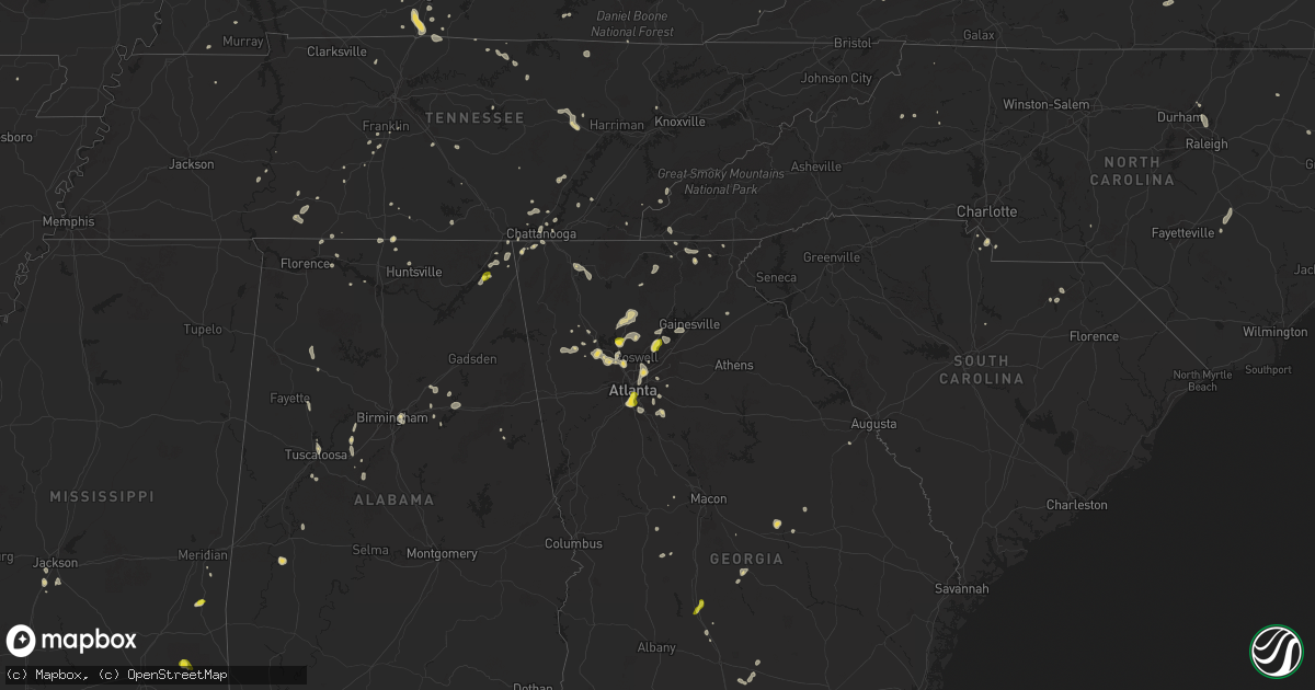
Hail Map on June 27, 2025
Get this storm
June 27 map
$229
one time, instant access
Download today. No call, no setup
Keep the $229
Bought the map and want the full workflow? Apply the entire $229 to a subscription within 7 days. None of it is wasted.
Every map, not just this one
This buys you this map. Subscription and you get every map we run, in the markets you choose from a few cities to whole states to nationwide. Plus real-time alerts the moment a storm fires.
Contact data
Name, contact info, occupancy, even credit band for addresses in the footprint. You go from where it hit to who to call.
Become the source they trust
Unlimited branding weather history reports on demand. You already have the documented answer ready for the property owner, and you are the one who showed up with it.
Property data and RoofTrace estimates
Pull up any address you have got, its value and the exact code rules for that jurisdiction, straight from One Click Code. Then RoofTrace estimates the squares, pitch, and roof value, priced the way you price.
States Impacted by Hail Map on June 27, 2025
Storm reports
Pennsylvania
| Date | Description |
|---|---|
| 06/27/20255:44 PM CDT | Large tree branch about 10 in diameter down on power lines. |
| 06/27/20255:38 PM CDT | A couple of trees were reported down on power lines at 697 wesley chapel road near the town of scottdale. |
| 06/27/20254:46 PM CDT | Reports of wires down along olean trail in limestone township. Time estimated from radar. |
| 06/27/20254:32 PM CDT | Report of a tree down along route 208 near the intersection with monte karlo road. Time estimated from radar. |
| 06/27/20254:30 PM CDT | A tree branch that was larger than 3 inches in diameter was down across pinewood terrace. |
| 06/27/20254:06 PM CDT | Large tree down on conewango ave at mader drive. |
| 06/27/20253:44 PM CDT | Tree down blocking the road along keith avenue. Time estimated from radar. |
| 06/27/20253:42 PM CDT | Report of a large tree down bringing multiple power poles and lines down with it near the 200 block of halyday street. Time estimated from radar. |
| 06/27/20253:10 PM CDT | Tree and wires down. Time estimated from radar. |
| 06/27/20252:12 PM CDT | Tree down across the road. |
| 06/27/20252:00 PM CDT | Wires down. Time estimated from radar. |
Florida
| Date | Description |
|---|---|
| 06/27/20254:10 PM CDT | The asos at the sanford international airport measured a wind gust of 60mph/52kts from the south-southeast. |
New York
| Date | Description |
|---|---|
| 06/27/20254:21 PM CDT | Delayed report... Time estimated based on radar. East holland rd between day rd and wilkins rd closed due to a downed tree in power lines. |
| 06/27/20252:51 PM CDT | Trees and wires down. |
Illinois
| Date | Description |
|---|---|
| 06/27/20252:55 PM CDT | Tree limbs down on silver creek hollow road in kampsville. Time estimated from radar. |
| 06/27/20251:07 PM CDT | Asos station kmto coles co. Mem ap. |
| 06/27/20251:00 PM CDT | Trees blown down on wires. |
New Mexico
| Date | Description |
|---|---|
| 06/27/20252:24 PM CDT | Asos station klvs las vegas muni airport. |
Alabama
| Date | Description |
|---|---|
| 06/27/20253:35 PM CDT | Quarter size hail was reported in the pisgah community. |
| 06/27/20253:35 PM CDT | A tree was reported down on cr 174 in the flat rock community. |
| 06/26/20258:46 PM CDT | Social media report of a downed tree on a home in cropwell. Time estimated by radar. |
| 06/26/20257:58 PM CDT | Multiple trees down on batavia ave... Some on homes. |
| 06/26/20257:42 PM CDT | Corrects previous tstm wnd dmg report from 2 ssw ruffner mountain. Multiple trees down in irondale... Including some on homes. |
| 06/26/20257:42 PM CDT | Multiple trees down in irondale. |
| 06/26/20257:42 PM CDT | Near i-20 and oporto madrid blvd. |
| 06/26/20257:35 PM CDT | Multiple trees down near brook leeds road. |
| 06/26/20257:25 PM CDT | *** 1 inj *** a tree fell on a home along redwood st... Resulting in an injury. |
Oklahoma
| Date | Description |
|---|---|
| 06/27/20253:59 PM CDT | Estimated 60 mph wind gusts at highway 88 and east 470 road north of claremore. |
| 06/27/20253:32 PM CDT | A local report indicates 72 MPH wind near 5 NNE Tulsa |
North Dakota
| Date | Description |
|---|---|
| 06/27/202512:30 AM CDT | Nddot sensor. |
| 06/26/202511:46 PM CDT | Time estimated from radar. |
| 06/26/202511:12 PM CDT | A local report indicates a tornado near 6 SSW Mckenzie |
| 06/26/202511:12 PM CDT | Law enforcement relayed report of tornado on the ground. |
| 06/26/202511:06 PM CDT | A local report indicates a tornado near 8 SE Driscoll |
| 06/26/202511:06 PM CDT | (bis |
| 06/26/202511:06 PM CDT | A local report indicates a tornado near 9 SSE Driscoll |
| 06/26/202511:00 PM CDT | Delayed report of two large trees |
| 06/26/202511:00 PM CDT | Delayed report of two large trees uprooted and laying on road. Time estimated by radar. |
| 06/26/202510:45 PM CDT | Relayed through broadcast media. Time estimated from radar. |
| 06/26/202510:43 PM CDT | A local report indicates a tornado near 3 WNW Menoken |
| 06/26/202510:29 PM CDT | Second of two tornadoes north of bismarck. Video footage of tornado on ground starting at 10:29 pm with dissipation at 10:34 pm. Tornado appeared to be slowly drifting |
| 06/26/202510:25 PM CDT | A local report indicates a tornado near 6 SSW Baldwin |
| 06/26/202510:22 PM CDT | Relayed through social media. Hail the size of a billiard ball. Time estimated from radar. |
| 06/26/202510:22 PM CDT | Report from icechip research project. |
| 06/26/202510:20 PM CDT | Photo relayed via social media. |
| 06/26/202510:19 PM CDT | Report from mping: hen egg+ |
| 06/26/202510:19 PM CDT | Second confirmed tornado from storm north of linton. Ndawn linton video shows initial rope tornado |
| 06/26/202510:19 PM CDT | Rep |
| 06/26/202510:15 PM CDT | Report from mping: quarter |
| 06/26/202510:14 PM CDT | Tornado has been intermittently touching the ground and lifting. Was on the ground at the time of report. |
| 06/26/20259:16 PM CDT | Relayed through social media. Time estimated from radar. |
| 06/26/20259:15 PM CDT | Report from mping: golf ball |
| 06/26/20258:53 PM CDT | Report relayed via broadcast media. |
| 06/26/20258:53 PM CDT | A local report indicates 2.50 inch wind near 6 SSW Orrin |
| 06/26/20258:49 PM CDT | Mixed with nickel sized hail. Relayed as photo via social media. |
| 06/26/20258:49 PM CDT | Report from mping: golf ball |
| 06/26/20258:42 PM CDT | Hail up to the size of baseballs was falling at the time of the report. Only a few hailstones... But some were as large as baseballs. |
| 06/26/20258:42 PM CDT | Hail up to the size of b |
| 06/26/20258:32 PM CDT | Quarter sized hail ongoing at time of call. |
| 06/26/20258:29 PM CDT | Trained spotter reported elephant trunk with faint intermittent brief ground circulations from their view. Lasted until 8:38 pm. |
| 06/26/20258:26 PM CDT | Report from icechip research project. Largest 47 mm... Most 20 to 35 mm. Noted from left mover. |
| 06/26/20258:25 PM CDT | Report from icechip research project. Time estimated from radar and hail measured a few minutes after it fell. |
| 06/26/20258:22 PM CDT | Report from mping: half dollar |
| 06/26/20258:21 PM CDT | Report from mping: golf ball |
| 06/26/20258:15 PM CDT | Report from icechip research project. |
| 06/26/20258:15 PM CDT | Hail quarter to half dollar size was falling at the time of the report. Winds of 40 to 50 mph preceded the hail. |
| 06/26/20258:07 PM CDT | Report from mping: ping pong ball |
| 06/26/20257:56 PM CDT | Relayed through social media. Time estimated from radar. |
| 06/26/20257:52 PM CDT | Time estimated by radar. Relayed via social media. |
| 06/26/20257:45 PM CDT | A few baseball size hail... Most golf ball sized. Relayed via broadcast media. |
| 06/26/20257:43 PM CDT | Report from mping: ping pong ball |
| 06/26/20257:41 PM CDT | Trained spotter and multiple public reports of a tornado at 7:41 pm. Tornado lasted approximately 9 minutes before ending. Photos of the tornado were sent via social me |
| 06/26/20257:35 PM CDT | Photo from skyspy photos of hail approximately 3 inches in diameter. |
| 06/26/20257:34 PM CDT | Relayed via broadcast media. |
| 06/26/20257:32 PM CDT | Relayed from social media. |
| 06/26/20257:31 PM CDT | Hail lasted until 7:38 pm. Largest was the size of tennis balls. |
| 06/26/20257:27 PM CDT | Relayed through social media. Largest hailstone was 3 inches in diameter. Also noted tree limbs down... A broken window... And lots of denting to shop and barn. |
| 06/26/20257:25 PM CDT | A local report indicates 1.75 inch wind near 10 W Hannover |
| 06/26/20257:20 PM CDT | Photo relayed via social media. |
| 06/26/20257:19 PM CDT | Hail... Mostly golf ball sized but some to tennis ball sized... Began at 7:19 pm and lasted until 7:34 pm. |
Montana
| Date | Description |
|---|---|
| 06/27/20255:35 PM CDT | War horse nw |
| 06/27/20252:01 PM CDT | Public measured a 59 mph wind gusts at 1:01 pm. |
Michigan
| Date | Description |
|---|---|
| 06/27/20254:36 PM CDT | Road blocked by 7 inch branch on waubascon rd at morgan rd. |
| 06/27/20254:12 PM CDT | Approximately 50 trees downed and some wires per hadley twp fire chief via lapeer county emergency management. |
| 06/27/20254:02 PM CDT | Tree down along grange hall rd east of the i-75 interchange. |
| 06/27/20252:58 PM CDT | 6 inch branches down on chandler rd. |
| 06/27/20252:57 PM CDT | Tree down on vehicle near woodbury rd and braiden rd. No injuries... But passenger reportedly stuck in vehicle. |
| 06/27/20252:57 PM CDT | Tree down on lansing rd blocking the eastbound lane near woodbury rd. |
| 06/27/20252:30 PM CDT | City of dewitt reports three streets blocked by fallen trees. |
| 06/27/20252:00 PM CDT | Large tree over the road. Time estimated from radar. |
| 06/27/20252:00 PM CDT | Trees and branches down in eagle. Time estimated from radar. |
Tennessee
| Date | Description |
|---|---|
| 06/27/20254:50 PM CDT | A facebook report of storm damage with a couple videos showcasing the following damage: couple dozen medium to large trees were blown down along kell loop road outside |
| 06/27/20254:25 PM CDT | Huge branch down in backyard of home in the hill city neighborhood. |
| 06/27/20254:24 PM CDT | A few trees are down at university of tennessee chattanooga. |
| 06/27/20254:18 PM CDT | Spotter estimates 50 mph winds with multiple trees down. |
| 06/27/20254:10 PM CDT | Facebook report of large branches and trees down in the suck creek area. |
| 06/27/20253:25 PM CDT | A tree was blown down along gifford ln bringing down power lines. |
South Dakota
| Date | Description |
|---|---|
| 06/27/20256:56 AM CDT | Corrects previous non-tstm wnd gst report from 4 w erwin. Mesonet station dtms2 de smet 7n. |
| 06/27/20256:56 AM CDT | Co |
| 06/27/202512:41 AM CDT | Pea to quarter size hail lasted 15 minutes. Time estimated from radar. |
| 06/26/202511:19 PM CDT | Via person |
| 06/26/202511:19 PM CDT | Via personal weather station. |
| 06/26/202510:53 PM CDT | Mesonet station 183 macs corner |
| 06/26/202510:43 PM CDT | Roof-mounted weather station measured an 83.1 mph wind gust. |
| 06/26/202510:37 PM CDT | Severe tree limbs downed by thunderstorm winds. Estimated 60 mph. |
| 06/26/202510:17 PM CDT | Mesonet station 26 sd rwis tripp. |
| 06/26/202510:15 PM CDT | Measured by a personal weather station. |
| 06/26/202510:13 PM CDT | Corrects previous tstm wnd gst report from 2 nw tripp. Mesonet station 26 sd rwis tripp. |
| 06/26/202510:03 PM CDT | Personal weather station reports peak wind gust of 60 miles per hour. Time estimated based on radar. |
| 06/26/20259:58 PM CDT | Measured by personal weather station. |
| 06/26/20259:52 PM CDT | A local report indicates 82 MPH wind near 4 E Corsica |
| 06/26/20259:49 PM CDT | Mesonet station 212 agar |
| 06/26/20259:45 PM CDT | Mesonet station onms2 onida 13wsw |
| 06/26/20259:44 PM CDT | Mesonet station 304 sd rwis corsica. |
| 06/26/20259:40 PM CDT | Mesonet station 304 sd rwis corsica. |
| 06/26/20259:38 PM CDT | Measured by personal weather station. |
| 06/26/20259:33 PM CDT | Several 4 inch diameter tree limbs down. |
| 06/26/20259:20 PM CDT | Mesonet station 214 sd rwis plankinton. |
| 06/26/20258:58 PM CDT | Mesonet station 154 sd rwis platte-winner bridge. |
| 06/26/20258:47 PM CDT | 69 mph severe wind measured 844 pm... 71 mph at 847 pm. Sdsu mesonet 3 nnw academy. |
| 06/26/20258:47 PM CDT | 69 mph sev |
| 06/26/20258:29 PM CDT | Sdsu mesonet station gregory 16n. |
| 06/26/20257:50 PM CDT | Storms lasted from 6:20 to 8:00 pm. Nickel size hail on and off. 60 mph wind gusts with the last storm that occurred at 7:50 pm. |
| 06/26/20257:25 PM CDT | A local report indicates 62 MPH wind near Union Center |
| 06/26/20257:10 PM CDT | 0.60 inches of rain and quarter size hail. Radar estimated time. |
Kansas
| Date | Description |
|---|---|
| 06/26/202510:48 PM CDT | Kgld reports 59 mph wind gust. |
Virginia
| Date | Description |
|---|---|
| 06/27/20256:50 PM CDT | Tree down along mountain lane terrace. |
| 06/27/20256:36 PM CDT | Tree downed by thunderstorm winds on shadwell drive near tinker creek. |
| 06/27/20256:31 PM CDT | Small tree down off davis lane. |
| 06/27/20256:26 PM CDT | Several trees down blocking part of coopers cove road... Near edwardsville road. |
| 06/27/20256:17 PM CDT | Corrects previous tstm wnd dmg report from 2 ne hot springs. 911 call center confirmed a tree down at the intersection of route 220 and cavendish lane. |
| 06/27/20256:17 PM CDT | 911 call center confirmed a tree down at the intersection of route 220 and cavendish lane. |
| 06/27/20256:17 PM CDT | 911 call center reported tree down along route 220 and forestry road in bath county virginia. |
| 06/27/20256:17 PM CDT | 911 call center reported tree down along route 220 and forestry road in bath county virginia. |
| 06/27/20256:17 PM CDT | 911 call center confirmed a tree down at the intersection of route 222 and cavendish lane. |
| 06/27/20255:33 PM CDT | Tree and wires down along fox creek road. |
| 06/26/20257:49 PM CDT | Several utility lines were blown down by thunderstorm winds in bedford. Time estimated from radar. |
West Virginia
| Date | Description |
|---|---|
| 06/27/20254:55 PM CDT | Tree reported down along price branch road. |
| 06/27/20253:00 PM CDT | Thunderstorm winds blew down several trees on to route 3 and other side roads between jumping branch and nimitz. Lightning from this storm also struck a couple trees an |
| 06/27/20252:56 PM CDT | 2 trees down. |
| 06/27/20252:40 PM CDT | Tree down reported on daisy trail just on the raleigh county side of the county line. |
| 06/27/202512:41 PM CDT | A few trees reported down on hammer run road. |
| 06/26/20258:38 PM CDT | Tree down on staunton turnpike... Blocking westbound lane. |
| 06/26/20258:28 PM CDT | Siding damage to a home on liberty ave. |
Texas
| Date | Description |
|---|---|
| 06/27/20253:20 PM CDT | Large tree limb broken on jefferson street. |
| 06/27/20253:20 PM CDT | A personal weather station recorded a 66 mph wind gust near pine and east second street in wichita falls. |
| 06/27/20253:15 PM CDT | Large tree uprooted... Multiple tree limbs broken and utility poles broken near downtown wichita falls. |
North Carolina
| Date | Description |
|---|---|
| 06/27/20255:22 PM CDT | Social media video of several trees down approximately 5 miles wnw of weaverville. |
| 06/27/20255:20 PM CDT | Tree down across road. |
| 06/27/20255:09 PM CDT | Tree down across mount moriah church rd. |
| 06/27/20255:09 PM CDT | Tree down across road on 600 block of old crow road. |
| 06/27/20255:03 PM CDT | Duke energy reported power outage caused by fallen trees or limbs. |
| 06/27/20254:58 PM CDT | Tree down across the road. Time estimated based on radar. |
| 06/27/20254:53 PM CDT | Duke energy reported a power outage caused by fallen trees or limbs damaging equipment. |
| 06/27/20254:27 PM CDT | Trees down along i-40. |
| 06/27/20253:48 PM CDT | Two trees down across the road in a dangerous curve. |
| 06/27/20253:40 PM CDT | 3 trees down. Time estimated from radar. |
| 06/26/20258:04 PM CDT | Tree blocking road. Time estimated from radar. |
Mississippi
| Date | Description |
|---|---|
| 06/27/20255:35 PM CDT | Tree down across highway 27. |
| 06/27/20255:00 PM CDT | Trees down on clinton-raymond rd. |
Indiana
| Date | Description |
|---|---|
| 06/27/20251:27 PM CDT | One tree uprooted and several large branches downed... Along with some corn flattened... At a property on legion road. |
| 06/27/20251:25 PM CDT | Numerous trees downed at lake in the pines campground. |
| 06/27/20251:20 PM CDT | Numerous large limbs downed at a property on mortashead road. |
Georgia
| Date | Description |
|---|---|
| 06/27/20256:57 PM CDT | Trained spotter reported flooding on the road and vehicles submerged along columns dr se near johnson ferry rd. |
| 06/27/20256:50 PM CDT | Public reports quarter-sized hail in forest park. |
| 06/27/20256:33 PM CDT | Report from mping: half dollar |
| 06/27/20256:24 PM CDT | Report from mping: half dollar |
| 06/27/20256:23 PM CDT | Report from mping: quarter |
| 06/27/20255:56 PM CDT | Tree reported down in the road at the 2000 block of ridge rd se. |
| 06/27/20255:56 PM CDT | Tree reported down in the road at the 200 block of hester cir. |
| 06/27/20255:54 PM CDT | Tree down in the road at the 1400 block of riverbend rd. |
| 06/27/20255:37 PM CDT | Power lines down on breedlove rd near amber lake dr. |
| 06/27/20254:55 PM CDT | Nickel to quarter-sized hail reported in holly springs. |
| 06/27/20254:37 PM CDT | A local report indicates 1.00 inch wind near 2 NE Chattanooga Valle |
| 06/27/20253:30 PM CDT | Ema reports quarter-sized hail south of cordele. |
| 06/26/20258:03 PM CDT | Damage to the colquitt county livestock barn. |
Ohio
| Date | Description |
|---|---|
| 06/27/20256:03 PM CDT | A local report indicates 58 MPH wind near 1 W Heath |
| 06/27/20256:03 PM CDT | Asos site kvta newark heath ohio. |
| 06/27/20255:21 PM CDT | Numerous large healthy limbs downed along tresham road. |
| 06/27/20255:14 PM CDT | Trees down. |
| 06/27/20255:07 PM CDT | Trees down. |
| 06/27/20254:44 PM CDT | Awos site ki67 cincinnati west airport. |
| 06/27/20254:37 PM CDT | Trees down. |
| 06/27/20254:09 PM CDT | Trees down. |
| 06/27/20253:48 PM CDT | Several trees snapped or uprooted along newlove road. |
| 06/27/20253:46 PM CDT | Numerous large branches downed on fletcher pike. |
| 06/27/20252:55 PM CDT | Tree down. Time estimated from radar. |
| 06/27/20252:16 PM CDT | Several trees downed near symmes road. |
| 06/27/20252:13 PM CDT | Tree downed on a house on dee alva drive. Numerous other trees downed in the same subdivision. |
| 06/27/20252:12 PM CDT | One tree and several large branches downed in fairfield near mississippi drive and wabash drive. |
| 06/27/202512:06 PM CDT | Buoy station faio1 fairport... Oh. |
| 06/27/202511:31 AM CDT | Tree downed along highland road in highland heights. |
| 06/27/202511:30 AM CDT | Tree downed along trebisky road in richmond heights. |
| 06/26/20257:20 PM CDT | Corrects previous flash flood report from 1 nne deersville. Numerous limbs down at tappan lake park. |
Kentucky
| Date | Description |
|---|---|
| 06/27/20255:20 PM CDT | Tree down on yeaman olaton road and free zion road near yeaman. |
| 06/27/20254:46 PM CDT | Tree down on brooklyn chapel road. |
| 06/27/20254:45 PM CDT | Tree down on 79 n caneyville road. |
| 06/27/20254:43 PM CDT | Warren recc working on a broken pole in morgantown that has caused scattered power outages. |
| 06/27/20254:32 PM CDT | Several tree limbs downed along hathaway road. |
| 06/27/20253:58 PM CDT | 911 call center reported trees over the roadway at springfield road and schweizer road. |
| 06/27/20253:58 PM CDT | 9 |
| 06/27/20253:22 PM CDT | Trees down and blocking roadways in plano. |
| 06/27/20251:08 PM CDT | Tree down on the roadway at 2609 possum trot rd. Time estimated from radar. |
| 06/27/202512:31 PM CDT | A couple of trees down on old calvary pike. One tree fell on a house. |
South Carolina
| Date | Description |
|---|---|
| 06/27/20255:53 PM CDT | Social media picture of a couple large pine limbs snapped in the fort mill area. |
Colorado
| Date | Description |
|---|---|
| 06/27/20254:57 PM CDT | Microburst at coagmet station. Time of gust estimated due to gust observations only reported at top of hour. |
| 06/27/20253:20 PM CDT | Asos station kcos colorado springs airport thunderstorm outflow wind gust. |
Missouri
| Date | Description |
|---|---|
| 06/27/20253:35 PM CDT | Limbs down near hildesheim ave. Time estimated. |
| 06/27/20253:31 PM CDT | Several large tree limbs snapped. Time estimated via radar. |
| 06/27/20253:21 PM CDT | Ksdk-tv aired a segment showing several large trees and limbs down. Time estimated by radar. |
| 06/27/20253:16 PM CDT | Gusts estimated 50 to 60 mph with small limbs down. |
| 06/27/20252:40 PM CDT | A picture was received of a large limb blown down. Time estimated from radar. |
Cities Impacted by Hail Map on June 27, 2025
- Opheim, MT
- Richland, MT
- Larslan, MT
- Scobey, MT
- Flaxville, MT
- Lemmon, SD
- Keldron, SD
- White River, SD
- Florence, AL
- Killen, AL
- Waynesboro, TN
- Collinwood, TN
- Summertown, TN
- Lexington, AL
- Loretto, TN
- Lawrenceburg, TN
- Iron City, TN
- Cypress Inn, TN
- Cleveland, OH
- Mount Pleasant, TN
- Euclid, OH
- Columbia, TN
- Town Creek, AL
- Hampshire, TN
- Lake Worth, FL
- Bloomingdale, MI
- Bangor, MI
- Granite City, IL
- Rogersville, AL
- Vero Beach, FL
- Spring Hill, TN
- Paw Paw, MI
- Bath Springs, TN
- Scotts Hill, TN
- Campbellsville, KY
- Gobles, MI
- Miami, OK
- Fairland, OK
- Pulaski, TN
- Thompsons Station, TN
- Franklin, TN
- Cornersville, TN
- Horse Cave, KY
- Hardyville, KY
- Lawrence, MI
- Decaturville, TN
- Fort Pierce, FL
- Elkmont, AL
- Prospect, TN
- Laurel Springs, NC
- Center, KY
- Edmonton, KY
- Munfordville, KY
- Ardmore, AL
- Hillsboro, AL
- Ardmore, TN
- Shelbyville, MI
- Wayland, MI
- Middleville, MI
- Decatur, AL
- Mattoon, IL
- Trilla, IL
- Lerna, IL
- Charleston, IL
- Winfield, TN
- Greensburg, KY
- Toney, AL
- Petersburg, TN
- Nolensville, TN
- Vossburg, MS
- Shubuta, MS
- Fayetteville, TN
- Strunk, KY
- Jamestown, TN
- Canmer, KY
- Afton, OK
- Welch, OK
- Bluejacket, OK
- Murfreesboro, TN
- Meridian, MS
- Huntsville, AL
- Richton, MS
- Great Falls, MT
- Floweree, MT
- Bradyville, TN
- Wellborn, FL
- Golden Eagle, IL
- Brussels, IL
- Lake City, FL
- Live Oak, FL
- Mount Morris, NY
- Konawa, OK
- Sasakwa, OK
- Scottsville, KY
- Patrick, SC
- Wichita Falls, TX
- Readyville, TN
- Youngstown, OH
- Geneseo, NY
- Tellico Plains, TN
- Seymour, TX
- Somerset, KY
- Byers, TX
- Belvidere, TN
- Clayton, GA
- Silver Point, TN
- Eastman, GA
- Manchester, TN
- Mount Sterling, KY
- Suches, GA
- Flat Top, WV
- Cool Ridge, WV
- Jumping Branch, WV
- Ghent, WV
- Springfield, TN
- Tomball, TX
- Bowling Green, KY
- Lake Wales, FL
- Randlett, OK
- Franklin, KY
- Stevenson, AL
- Flat Rock, AL
- Blue Ridge, GA
- Hawkinsville, GA
- Ridgedale, MO
- Omaha, AR
- Cordele, GA
- Cypress, TX
- Pisgah, AL
- Augusta, GA
- Blythe, GA
- Sapulpa, OK
- Mannford, OK
- Kellyville, OK
- Bristow, OK
- Sand Springs, OK
- Tulsa, OK
- Owingsville, KY
- Ellijay, GA
- Petrolia, TX
- Dutton, AL
- Alvaton, KY
- Sandy Hook, KY
- Olive Hill, KY
- Owasso, OK
- Catoosa, OK
- London, KY
- New Bern, NC
- Whitleyville, TN
- Gainesboro, TN
- Floral City, FL
- Higdon, AL
- Westmoreland, TN
- Portland, TN
- Woodburn, KY
- Model, CO
- Demopolis, AL
- Raccoon, KY
- Wrightsville, GA
- Bryant, AL
- Sulphur, OK
- Saint Louis, MO
- Ballwin, MO
- Arabi, GA
- Bartlesville, OK
- Delaware, OK
- Nowata, OK
- Young Harris, GA
- Adolphus, KY
- Okeechobee, FL
- Chattanooga, TN
- Pikeville, KY
- Shelbiana, KY
- Dixon, MO
- Davis, OK
- Hiawassee, GA
- Casselberry, FL
- Oviedo, FL
- Winter Springs, FL
- Sanford, FL
- Winter Park, FL
- Deltona, FL
- Osteen, FL
- Dublin, GA
- Albany, KY
- Monticello, KY
- Enfield, NC
- Whitakers, NC
- Blairsville, GA
- Brasstown, NC
- Trenton, GA
- Rising Fawn, GA
- Wildwood, GA
- West Liberty, KY
- Gordon, NE
- Bingham, NE
- Rushville, NE
- Ellsworth, NE
- Alva, WY
- Aladdin, WY
- Sundance, WY
- Signal Mountain, TN
- Holliday, TX
- Union, WV
- Knox City, TX
- East Dublin, GA
- Russellville, KY
- Red Boiling Springs, TN
- Murphy, NC
- Ashby, NE
- Beulah, WY
- Hollister, NC
- Melbourne, AR
- Maysville, OK
- Ringling, OK
- Canton, GA
- Kingston, GA
- Cumming, GA
- Morgantown, KY
- Flintstone, GA
- Lookout Mountain, GA
- Woodstock, GA
- Lexington, OK
- Noble, OK
- Norman, OK
- Buford, GA
- Cookeville, TN
- Akron, CO
- Otis, CO
- Suwanee, GA
- Duluth, GA
- Ellerbe, NC
- Cochranton, PA
- Utica, PA
- Fulton, KY
- Alpharetta, GA
- Flowery Branch, GA
- Grass Range, MT
- Winnett, MT
- Kilgore, NE
- Crookston, NE
- Trementina, NM
- Livingston, TN
- Whitwell, TN
- Felicity, OH
- Georgetown, OH
- Hamersville, OH
- Waleska, GA
- Plymouth, NC
- Greensboro, AL
- Henrietta, TX
- Atlanta, GA
- Gainesville, GA
- Oakwood, GA
- Sedalia, KY
- Dunlap, TN
- Ball Ground, GA
- Conchas Dam, NM
- Middletown, MO
- Valley Park, MO
- Aragon, GA
- Wake Forest, NC
- Raleigh, NC
- Hebron, OH
- Heath, OH
- Granville, OH
- Newark, OH
- Hixson, TN
- Rossville, GA
- Newton Grove, NC
- Dunn, NC
- Rockmart, GA
- Cedartown, GA
- Cleveland, TN
- Dalton, GA
- Clinton, NC
- Graysville, TN
- Fort Mill, SC
- Waxhaw, NC
- Presho, SD
- Crossville, TN
- Granville, ND
- Towner, ND
- Karlsruhe, ND
- Douglas, ND
- Ryder, ND
- Horse Branch, KY
- Kennebec, SD
- Scotts, MI
- Vicksburg, MI
- Dallas, GA
- Colorado Springs, CO
- Jasper, GA
- Taylorsville, GA
- Beulah, ND
- New Salem, ND
- Hazen, ND
- Reliance, SD
- Vivian, SD
- Georgetown, TN
- Dayton, TN
- Kennesaw, GA
- Marietta, GA
- Decatur, GA
- Acworth, GA
- Nathalie, VA
- Circleville, OH
- Tarboro, NC
- Eureka, MO
- Forest Park, GA
- Chatsworth, GA
- Rugby, ND
- Max, ND
- Minot, ND
- Sawyer, ND
- Garrison, ND
- Stanton, ND
- Center, ND
- Lithonia, GA
- Moss, TN
- Morrow, GA
- Stockbridge, GA
- Russellville, OH
- Ripley, OH
- Ellenwood, GA
- Voltaire, ND
- Velva, ND
- Ruso, ND
- Benedict, ND
- Anamoose, ND
- Fenton, MO
- Lafayette, TN
- Peachtree Corners, GA
- Norcross, GA
- Rex, GA
- Lupton City, TN
- Stone Mountain, GA
- Ryan, OK
- Rock Hill, SC
- Drake, ND
- Balta, ND
- Willow City, ND
- New Underwood, SD
- Sturgis, SD
- Union Center, SD
- Enning, SD
- White Owl, SD
- Faith, SD
- Owanka, SD
- Howes, SD
- Wasta, SD
- Mud Butte, SD
- Wall, SD
- Cherry Creek, SD
- Milesville, SD
- Eagle Butte, SD
- Dupree, SD
- Lantry, SD
- Esmond, ND
- Mandan, ND
- Mcdonough, GA
- Vicco, KY
- Littcarr, KY
- Hindman, KY
- Hardy, VA
- Elmore City, OK
- Balfour, ND
- Tucker, GA
- Isabel, SD
- Timber Lake, SD
- Gleason, TN
- Mallie, KY
- Pine Top, KY
- Carrie, KY
- Jonesboro, GA
- Lilburn, GA
- Skiatook, OK
- Hamill, SD
- Bismarck, ND
- Baldwin, ND
- Oacoma, SD
- Chamberlain, SD
- Gregory, SD
- Winner, SD
- Platte, SD
- Burke, SD
- White Lake, SD
- Kimball, SD
- Pukwana, SD
- Dunning, NE
- Butte, ND
- Ideal, SD
- Moneta, VA
- Williamsport, OH
- Macomb, OK
- Goodview, VA
- Meta, MO
- Argyle, MO
- Harvey, ND
- York, ND
- Ridgeview, SD
- Saint Francis, SD
- Mission, SD
- Turtle Lake, ND
- Menoken, ND
- Clarkson, KY
- Tuscaloosa, AL
- Northport, AL
- Lone Grove, OK
- Ardmore, OK
- Wayne, OK
- Kim, CO
- Conyers, GA
- West Blocton, AL
- Birmingham, AL
- Brookwood, AL
- Woodstock, AL
- McCalla, AL
- Vance, AL
- Moundville, AL
- Stoutsville, OH
- Fort Myers, FL
- Geddes, SD
- Harrison, SD
- Stickney, SD
- Plankinton, SD
- Corsica, SD
- New Holland, SD
- Armour, SD
- Adair, OK
- Big Cabin, OK
- Wilton, ND
- Hartsville, SC
- Tecumseh, OK
- Fort Pierre, SD
- Onida, SD
- Agar, SD
- Pierre, SD
- Gettysburg, SD
- Linton, ND
- Mcclusky, ND
- Martin, ND
- Denhoff, ND
- Maddock, ND
- Lebanon, SD
- Hoven, SD
- Harrold, SD
- Mount Vernon, SD
- Mitchell, SD
- Lake Andes, SD
- Ethan, SD
- Parkston, SD
- Delmont, SD
- Dimock, SD
- Riverdale, GA
- Gallion, AL
- Benton, KY
- Florence, MS
- Goodrich, ND
- Sterling, ND
- Driscoll, ND
- Fessenden, ND
- Tolstoy, SD
- Onaka, SD
- Bowdle, SD
- Holabird, SD
- Highmore, SD
- Seneca, SD
- Tripp, SD
- Alexandria, SD
- Fulton, SD
- Wagner, SD
- Avon, SD
- Olivet, SD
- Franklinton, LA
- Byram, MS
- Terry, MS
- Lewistown, MT
- Hardin, KY
- Jackson, MS
- Hazelton, ND
- Steele, ND
- Hurdsfield, ND
- Chaseley, ND
- Cathay, ND
- New Rockford, ND
- Sheyenne, ND
- Prairie City, SD
- Reva, SD
- Charleston, TN
- Calhoun, TN
- Amanda, OH
- Auburn, KY
- Springville, AL
- Jackson, KY
- Odenville, AL
- Idalia, CO
- Nashville, GA
- Alapaha, GA
- Piketon, OH
- Burlington, CO
- Kirk, CO
- Shawnee, OK
- Willacoochee, GA
- Mcloud, OK
- Bowdon, ND
- Tippecanoe, OH
- Lenox, GA
- Crawfordville, GA
- Homer, GA
- Taylorsville, NC
- Tarlton, OH
- Laurelville, OH
- Monroe, LA
- Sykeston, ND
- Providence, KY
- Boomer, NC
- Gunlock, KY
- Lincoln, AL
- Pell City, AL
- Riverside, AL
- Cromwell, KY
- Pantego, NC
- Bastrop, LA
- Kanorado, KS
- Ashville, AL
- Clinton, TN
- Rocky Face, GA
- Springfield, SD
- Tyndall, SD
- Scotland, SD
- Dante, SD
- Kaylor, SD
- Freeman, SD
- Bridgewater, SD
- Canistota, SD
- Marion, SD
- Spencer, SD
- Menno, SD
- Emery, SD
- Lower Brule, SD
- Fort Thompson, SD
- Blunt, SD
- Miller, SD
- Stephan, SD
- Faulkton, SD
- Orient, SD
- Goodland, KS
- Edson, KS
- Brewster, KS
- Carrington, ND
- Woodworth, ND
- Braddock, ND
- Dawson, ND
- Glenham, SD
- Talladega, AL
- Ashburn, GA
- Sycamore, GA
- Hayes, SD
- Whitehorse, SD
- Colby, KS
- Levant, KS
- Ree Heights, SD
- Gann Valley, SD
- Niobrara, NE
- Tabor, SD
- Lesterville, SD
- Bloomfield, NE
- Crofton, NE
- Yankton, SD
- Utica, SD
- Parker, SD
- Irene, SD
- Viborg, SD
- Monroe, SD
- Hurley, SD
- Jamestown, ND
- Musella, GA
- Bogalusa, LA
- Merriman, NE
- Ragland, AL
- Snellville, GA
- Cedar Bluff, VA
- Rebecca, GA
- Pataskala, OH
- Wessington Springs, SD
- Wessington, SD
- Saint Lawrence, SD
- Alpena, SD
- Virgil, SD
- Volin, SD
- Saint Helena, NE
- Wakonda, SD
- Gayville, SD
- Hartington, NE
- Wynot, NE
- Chancellor, SD
- Mission Hill, SD
- Lennox, SD
- Centerville, SD
- Davis, SD
- Vermillion, SD
- Beresford, SD
- Fordyce, NE
- Hague, ND
- Buchanan, ND
- Pingree, ND
- Purdum, NE
- Cartersville, GA
- Moffit, ND
- Kintyre, ND
- Tappen, ND
- Napoleon, ND
- Selby, SD
- Wishek, ND
- Colton, SD
- Lynn, AL
- Emmalena, KY
- Marion, KY
- Robinson, ND
- Lenoir, NC
- Beaver Dam, KY
- Sanborn, ND
- Van Buren, MO
- Olaton, KY
- Chester, SD
- Delta, AL
- Doniphan, MO
- Gatewood, MO
- Lineville, AL
- Lisbon, ND
- Rogers, ND
- Verona, ND
- Oakes, ND
- Lamoure, ND
- Marion, ND
- Dickey, ND
- Pettibone, ND
- Egan, SD
- Reynolds, GA
- Montpelier, ND
- Roseboro, NC
- Conley, GA
- Toronto, OH
- Jud, ND
- Salemburg, NC
- Zeeland, ND
- Flandreau, SD
- Wallace, KS
- Steubenville, OH
- Weirton, WV
- Centreville, AL
- Brierfield, AL
- Collettsville, NC
- Tuttle, ND
- Woodbury, TN
- Cleveland, ND
- Wimbledon, ND
- Spiritwood, ND
- Ypsilanti, ND
- Las Vegas, NM
- Milnor, ND
- Winona, KS
- Litchville, ND
- South Bloomingville, OH
- Cayuga, ND
- Ashley, ND
- Fort Ransom, ND
- Wyndmere, ND
- Lidgerwood, ND
- Hankinson, ND
- Brewster, NE
- Whitesburg, KY
- Mantador, ND
- Adger, AL
- Creedmoor, NC
- Rosholt, SD
- Draper, SD
- Fairmount, ND
- Wheaton, MN
- Sargent, NE
- Barney, ND
- Mooreton, ND
- Yeaddiss, KY
- Cottonwood, MN
- Aneta, ND
- Binford, ND
- Taylor, NE
- Hanley Falls, MN
- Vesta, MN
- Wood Lake, MN
- Stratton, CO
- Tintah, MN
- Norcross, MN
- Freeport, OH
- Campbell, MN
- Oakley, KS
- Berry, AL
- Milroy, MN
- Bethune, CO
- Walnut Grove, MN
- Lucan, MN
- Morris, MN
- Donnelly, MN
- Chokio, MN
- Herman, MN
- Windom, MN
- Jeffers, MN
- Wabasso, MN
- Hancock, MN
- Le Mars, IA
- Bingham Lake, MN
- Wakpala, SD
- Thaxton, VA
- Vinton, VA
- Cyrus, MN
- Springfield, MN
- Sanborn, MN
- Merrill, IA
- Burwell, NE
- Starbuck, MN
- Heron Lake, MN
- Alberta, MN
- Hinton, IA
- Mountain Lake, MN
- Valentine, NE
- Kingsley, IA
- Benson, MN
- Glenwood, MN
- Kerkhoven, MN
- Pennock, MN
- Deane, KY
- Murdock, MN
- Knobel, AR
- Hoffman, MN
- Comfrey, MN
- Butterfield, MN
- Evansville, MN
- Barrett, MN
- Pollock, SD
- Boise City, OK
- Clontarf, MN
- Trimont, MN
- Odin, MN
- Sunburg, MN
- Saint Francis, KS
- Saint James, MN
- Brooten, MN
- New London, MN
- Belgrade, MN
- Moville, IA
- Wray, CO
- Gruver, TX
- Herreid, SD
- Walsh, CO
- Elbow Lake, MN
- Vincent, AL
- Cropwell, AL
- Alpine, AL
- Ormsby, MN
- Truman, MN
- Sioux City, IA
- Lawton, IA
- Carbon Hill, AL
- Haleyville, AL
- Honaker, VA
- Belle Fourche, SD
- Swords Creek, VA
- Raven, VA
- Oakwood, VA
- Richmond, OH
- Walker, WV
- Follansbee, WV
- Anthon, IA
- Correctionville, IA
- Blue Earth, MN
- Elmore, MN
- Colliers, WV
- Mingo Junction, OH
- Thedford, NE
- Clare, IA
- Eastlake, OH
- Wickliffe, OH
- Buffalo, MN
- Delano, MN
- Temple, OK
- Rockford, MN
- Ridgeway, SC
- Sharon Springs, KS
- Milaca, MN
- Hitchcock, SD
- Mora, MN
- Isle, MN
- Brook Park, MN
- Hinckley, MN
- Sandstone, MN
- Pine City, MN
- Grasston, MN
- Carpenter, SD
- Pinetown, NC
- Elk Point, SD
- Huron, SD
- Trent, SD
- Yale, SD
- Willow Lake, SD
- Jefferson, SD
- Westfield, IA
- Iroquois, SD
- Monument, KS
- Montezuma, GA
- Oglethorpe, GA
- Brookings, SD
- De Smet, SD
- Bryant, SD
- Erwin, SD
- Volga, SD
- Lake Preston, SD
- Arlington, SD
- Bruce, SD
- Wolsey, SD
- Emerson, GA
- Soddy Daisy, TN
- Washburn, ND