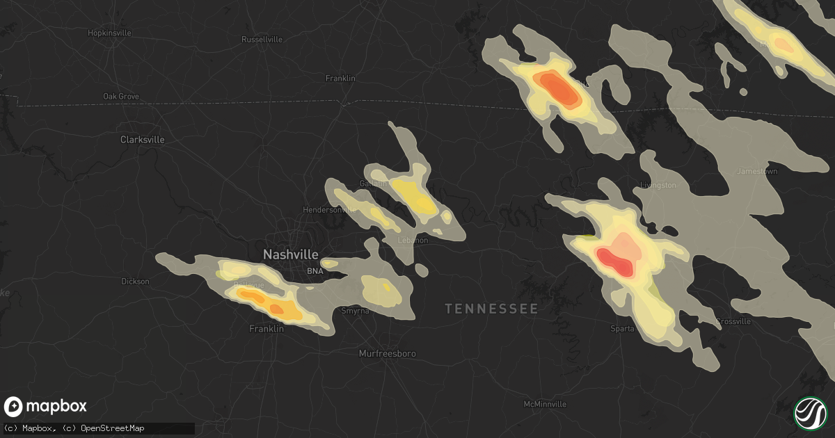
Hail Map in Lebanon, TN on July 14, 2015
Get this storm
July 14 map
$229
one time, instant access
Download today. No call, no setup
Keep the $229
Bought the map and want the full workflow? Apply the entire $229 to a subscription within 7 days. None of it is wasted.
Every map, not just this one
This buys you this map. Subscription and you get every map we run, in the markets you choose from a few cities to whole states to nationwide. Plus real-time alerts the moment a storm fires.
Contact data
Name, contact info, occupancy, even credit band for addresses in the footprint. You go from where it hit to who to call.
Become the source they trust
Unlimited branding weather history reports on demand. You already have the documented answer ready for the property owner, and you are the one who showed up with it.
Property data and RoofTrace estimates
Pull up any address you have got, its value and the exact code rules for that jurisdiction, straight from One Click Code. Then RoofTrace estimates the squares, pitch, and roof value, priced the way you price.
Storm reports in Lebanon, TN
Lebanon, TN
| Date | Description |
|---|---|
| 07/14/20153:05 PM CDT | Power lines and trees down along double log cabin road |
| 07/14/20152:57 PM CDT | Trees and power lines down around the rocky valley road area |
| 07/14/20152:51 PM CDT | Trees uprooted and power lines down near lebanon near coles ferry road and berea church road and academy road |
| 07/14/20152:40 PM CDT | Photos show hail up to ping pong ball size fell in northeast wilson county |
All States Impacted by Hail Map on July 14, 2015
All Cities Impacted by Hail Map on July 14, 2015
- Morland, KS
- Clayton, KS
- Selden, KS
- Rapid City, SD
- Only, TN
- Hurricane Mills, TN
- Nunnelly, TN
- Waverly, TN
- McEwen, TN
- Centerville, TN
- Crossville, TN
- Crab Orchard, TN
- Oakdale, TN
- Rockwood, TN
- Harriman, TN
- Ruidoso Downs, NM
- Arcadia, NE
- Lebanon, TN
- Winner, SD
- Gamaliel, KY
- Tompkinsville, KY
- Hestand, KY
- Oconto, NE
- Valentine, NE
- Parshall, ND
- New Town, ND
- Sardis, TN
- Adamsville, TN
- Morris Chapel, TN
- Saltillo, TN
- Crump, TN
- Savannah, TN
- Stapleton, NE
- Bowersville, GA
- Canon, GA
- Eureka, KS
- Paragould, AR
- Velva, ND
- Minot, ND
- Surrey, ND
- Grafton, ND
- Hoople, ND
- Park River, ND
- Pleasanton, NE
- Beaver, OH
- Waverly, OH
- Sundance, WY
- Elkhart, KS
- Walsh, CO
- Campo, CO
- Nevada, MO
- Stockton, MO
- Jerico Springs, MO
- El Dorado Springs, MO
- Moundville, MO
- Deerfield, MO
- Sheldon, MO
- Fort Scott, KS
- Milo, MO
- Voltaire, ND
- Bryson City, NC
- Almond, NC
- Jackson, TN
- Quincy, KY
- Ord, NE
- Burwell, NE
- Lead, SD
- Teasdale, UT
- Arnold, NE
- Callaway, NE
- Yates Center, KS
- Elsmore, KS
- Virgil, KS
- Savonburg, KS
- Piqua, KS
- Humboldt, KS
- La Harpe, KS
- Iola, KS
- Toronto, KS
- Neosho Falls, KS
- Iron City, TN
- Florence, AL
- Holly, CO
- Bazine, KS
- Alexander, KS
- Hoxie, KS
- Stratton, CO
- Bethune, CO
- Lancaster, MN
- Morrisville, MO
- Marshfield, MO
- Half Way, MO
- Brighton, MO
- Bolivar, MO
- Pleasant Hope, MO
- Elkland, MO
- Fair Grove, MO
- Buffalo, MO
- Martin, GA
- Lavonia, GA
- Burlington, CO
- Huntsville, AL
- Huntland, TN
- Belvidere, TN
- Bel Air, MD
- Minneapolis, KS
- Bennington, KS
- Andrews, NC
- Marble, NC
- Briceville, TN
- Caryville, TN
- Johnson, KS
- Nolensville, TN
- Brentwood, TN
- Nashville, TN
- Franklin, TN
- Osceola, AR
- Park, KS
- Tallahassee, FL
- Crawfordville, FL
- Natoma, KS
- Ada, OH
- Lima, OH
- Fort Jennings, OH
- Columbus Grove, OH
- Hazelton, ND
- Gilbert, AZ
- Chandler, AZ
- Robbinsville, NC
- Chattanooga, TN
- Strafford, MO
- Chippewa Lake, OH
- Seville, OH
- Medina, OH
- Kennesaw, GA
- Garryowen, MT
- Page, NE
- Winnetoon, NE
- Orchard, NE
- Ezel, KY
- Vona, CO
- Petersburg, TN
- Pulaski, TN
- Frankewing, TN
- Dyersburg, TN
- Friendship, TN
- Glasco, KS
- Tullahoma, TN
- Clearville, PA
- Quinter, KS
- Woodston, KS
- Plainville, KS
- Alton, KS
- Cookeville, TN
- Williston, ND
- Bogue, KS
- Damar, KS
- Donalsonville, GA
- Dresden, KS
- Sparks, GA
- Summerville, GA
- Mentone, AL
- Lyerly, GA
- Menlo, GA
- Gaylesville, AL
- White Bluff, TN
- Hazlehurst, GA
- Palco, KS
- Hill City, KS
- Pall Mall, TN
- Jamestown, TN
- Byrdstown, TN
- Monroe, TN
- Albany, KY
- Monette, AR
- Black Oak, AR
- Idalia, CO
- Garden City, KS
- Madison, AL
- Lucasville, OH
- Argillite, KY
- West Portsmouth, OH
- West Union, OH
- Portsmouth, OH
- Lynx, OH
- Stout, OH
- South Portsmouth, KY
- Vanceburg, KY
- Olive Hill, KY
- Otway, OH
- Wheelersburg, OH
- Ironton, OH
- Friendship, OH
- Greenup, KY
- Worthington, KY
- Blue Creek, OH
- Franklin Furnace, OH
- Manchester, OH
- Grayson, KY
- Peebles, OH
- Garrison, KY
- South Shore, KY
- Maxwell, NE
- Anselmo, NE
- Cheyenne Wells, CO
- Pottersville, MO
- Drury, MO
- Dora, MO
- Vanzant, MO
- West Plains, MO
- Elyria, NE
- Murphy, NC
- Ness City, KS
- Burkesville, KY
- Duff, TN
- La Follette, TN
- Pioneer, TN
- Newcomb, TN
- Hoskins, NE
- Lobelville, TN
- Holladay, TN
- Ripley, WV
- Trenton, TN
- Litchfield, NE
- Loup City, NE
- Ardmore, TN
- Dellrose, TN
- Seymour, MO
- Dahlonega, GA
- Suches, GA
- Campton, KY
- Rockbridge, OH
- Topton, NC
- Walnut Ridge, AR
- Pocahontas, AR
- Sparta, TN
- Jefferson City, TN
- New Market, TN
- Dandridge, TN
- Burbank, OH
- Lodi, OH
- West Salem, OH
- Homerville, OH
- Jackson, OH
- Bunker Hill, KS
- Dorrance, KS
- Springfield, CO
- Rogersville, TN
- Whitesburg, TN
- Waynesboro, TN
- Dadeville, MO
- Dickson, TN
- Hartsville, TN
- Gallatin, TN
- Castalian Springs, TN
- Bethpage, TN
- Harvest, AL
- Jonesboro, AR
- Beech Grove, AR
- Brookland, AR
- Bono, AR
- Register, GA
- Le Roy, WV
- Baxter, TN
- Monterey, TN
- Bloomington Springs, TN
- Pompano Beach, FL
- Deerfield Beach, FL
- Holcomb, KS
- Dola, OH
- Kenton, OH
- Epping, ND
- Emporia, KS
- Farner, TN
- Madisonville, TN
- Sweetwater, TN
- Englewood, TN
- Tellico Plains, TN
- Reliance, TN
- Turtletown, TN
- Vonore, TN
- Woodbine, KY
- Riddleton, TN
- Dixon Springs, TN
- Letart, WV
- Leon, WV
- Glasgow, KY
- Gainesboro, TN
- Dalhart, TX
- Piketon, OH
- Manila, AR
- Tescott, KS
- Clarkrange, TN
- Ethridge, TN
- Rogersville, AL
- Page, ND
- Hope, ND
- Monticello, KY
- Carlisle, KY
- Owingsville, KY
- Flemingsburg, KY
- Sharpsburg, KY
- Hillsboro, KY
- Moorefield, KY
- Ewing, KY
- Keyes, OK
- Boise City, OK
- Humboldt, TN
- Evensville, TN
- Gridley, KS
- Madison, KS
- Livingston, TN
- Fairburn, SD
- Falkville, AL
- Adairsville, GA
- Stanton, NE
- Athens, AL
- Front Royal, VA
- Imboden, AR
- Ravenden, AR
- Hazard, NE
- Pierce, NE
- Norfolk, NE
- Chickamauga, GA
- Trenton, GA
- La Fayette, GA
- Rising Fawn, GA
- Lookout Mountain, GA
- Wildwood, GA
- Wakeeney, KS
- Collyer, KS
- Comstock, NE
- Keystone, SD
- Deadwood, SD
- Ellis, KS
- Lakeland, GA
- Ray City, GA
- Leitchfield, KY
- Grenora, ND
- Sugar Tree, TN
- Camden, TN
- Lamar, CO
- Hammonton, NJ
- Grimsley, TN
- Deer Lodge, TN
- Willow Springs, MO
- Pomona, MO
- McRae Helena, GA
- Mammoth Spring, AR
- Minto, ND
- Forest River, ND
- Gove, KS
- Minford, OH
- Leachville, AR
- Trion, GA
- Maynard, AR
- Couch, MO
- Gatewood, MO
- Warm Springs, AR
- Hill City, SD
- Columbia, TN
- Athens, OH
- Clayton, NM
- Quincy, FL
- Mount Juliet, TN
- Center, ND
- Williamstown, WV
- Fleming, OH
- Marietta, OH
- New Holland, OH
- Chillicothe, OH
- Frankfort, OH
- Ransom, KS
- Utica, KS
- Philadelphia, TN
- Cairo, OH
- Rush Center, KS
- Walnut, MS
- Black Rock, AR
- Saint Xavier, MT
- Foxhome, MN
- Henderson, TN
- Bethel Springs, TN
- Finger, TN
- Willard, MO
- Franklin, NC
- Gassaway, WV
- Exchange, WV
- Helenwood, TN
- Balfour, ND
- Newcastle, WY
- Leoti, KS
- Deerfield, KS
- Marienthal, KS
- Scott City, KS
- Boynton Beach, FL
- Hamilton, KS
- Vincent, OH
- Harrison, TN
- Hixson, TN
- Manchester, TN
- Alma, NE
- Republican City, NE
- Hohenwald, TN
- Lawrenceburg, TN
- Gallina, NM
- Rocky Top, TN
- Nelsonville, OH
- Logan, OH
- Haydenville, OH
- Union Furnace, OH
- Miracle, KY
- Pineville, KY
- Middlesboro, KY
- Beloit, KS
- Tipton, KS
- Hunter, KS
- Tyrone, PA
- Warriors Mark, PA
- Rome, GA
- Kingston, GA
- Blytheville, AR
- Manhattan, KS
- Swainsboro, GA
- Soperton, GA
- Lyons, GA
- Blackshear, GA
- Linden, TN
- Collinwood, TN
- Westpoint, TN
- Lenora, KS
- Norton, KS
- Dublin, GA
- Mays Landing, NJ
- Egg Harbor Township, NJ
- Holland, KY
- Scottsville, KY
- Lafayette, TN
- Lodge Grass, MT
- Hasty, CO
- Rickman, TN
- Allred, TN
- Crawford, TN
- Alpine, TN
- Dayton, TN
- Rienzi, MS
- Ruckersville, VA
- Stanardsville, VA
- Madison, VA
- Hood, VA
- Upton, WY
- Abiquiu, NM
- Bulls Gap, TN
- Mosheim, TN
- Greeneville, TN
- Osborne, KS
- Bidwell, OH
- Gallipolis, OH
- Gallipolis Ferry, WV
- Bald Knob, AR
- Clifton, TN
- Kingston, TN
- Hays, KS
- Somerset, KY
- Sabina, OH
- Washington Court House, OH
- Morrison, TN
- Bradyville, TN
- Newport, AR
- McCrory, AR
- Millville, NJ
- Cedar Grove, TN
- Huntingdon, TN
- Wilder, TN
- Mountain View, AR
- Wilson, KS
- Ellsworth, KS
- Broken Bow, NE
- Ball Ground, GA
- Jasper, GA
- Gillette, WY
- Creston, OH
- Laceys Spring, AL
- Sylvania, GA
- Millen, GA
- Rocky Ford, GA
- Clay Center, KS
- Heaters, WV
- Napier, WV
- Pennsylvania Furnace, PA
- Moss, TN
- Eubank, KY
- Mount Vernon, KY
- London, KY
- Wilmington, OH
- Leesburg, OH
- New Vienna, OH
- Cincinnati, OH
- Ft Mitchell, KY
- Covington, KY
- Erlanger, KY
- Florence, KY
- Hebron, KY
- Pegram, TN
- Thorn Hill, TN
- Mooresburg, TN
- Sneedville, TN
- Almond, NY
- Arkport, NY
- Hayesville, NC
- Brasstown, NC
- Milan, TN
- Medina, TN
- Perham, MN
- Blanchester, OH
- Fayetteville, OH
- Benton, TN
- Delano, TN
- Cullman, AL
- Bascom, FL
- Martinsville, OH
- Bells, TN
- Creighton, NE
- Blairsville, GA
- Mason City, NE
- Emerson, KY
- Young, AZ
- Stockport, OH
- Waterford, OH
- Lakeside, NE
- Vina, AL
- Oak Hill, OH
- South Webster, OH
- Alexander, ND
- Watford City, ND
- Tishomingo, MS
- Bristolville, OH
- North Bloomfield, OH
- Cortland, OH
- Fairmount, ND
- Campbell, MN
- Tintah, MN
- Bolivar, TN
- Hickory Valley, TN
- Catharine, KS
- Lascassas, TN
- Murfreesboro, TN
- La Vergne, TN
- Smyrna, TN
- Westport, TN
- Trezevant, TN
- Yuma, TN
- McKenzie, TN
- Buena Vista, TN
- Hanceville, AL
- Crane Hill, AL
- Bremen, AL
- South Solon, OH
- Bloomingburg, OH
- Mount Sterling, OH
- London, OH
- Broxton, GA
- Beersheba Springs, TN
- Altamont, TN
- Harrod, OH
- Tanner, AL
- Mansfield, MO
- Hitchins, KY
- Denton, KY
- Tremont, MS
- Hamilton, AL
- Anderson, AL
- Lexington, AL
- Rector, AR
- Marmaduke, AR
- Delray Beach, FL
- Transfer, PA
- Greenville, PA
- Fredonia, PA
- McClave, CO
- Townsend, TN
- Cord, AR
- Newark, AR
- Antioch, TN
- New Haven, KY
- Raywick, KY
- New Hope, KY
- Campbellsville, KY
- Charleston, WV
- Georgetown, OH
- Hamersville, OH
- Prospect, TN
- Ardmore, AL
- Taft, TN
- Fayetteville, TN
- Pritchett, CO
- Luttrell, TN
- Maynardville, TN
- Powder Springs, TN
- Hillsboro, OH
- Sunbright, TN
- Robbins, TN
- Frederick, MD
- Middletown, MD
- Delphos, KS
- Huron, TN
- Scotts Hill, TN
- Lexington, TN
- Reagan, TN
- Lula, GA
- Murrayville, GA
- Cleveland, GA
- Mountain View, MO
- Milford Center, OH
- North Lewisburg, OH
- Pangburn, AR
- Lake City, FL
- Hermosa, SD
- Tohatchi, NM
- Eustis, FL
- Spencer, TN
- Lake City, AR
- Young Harris, GA
- Warne, NC
- Fair Play, MO
- Aldrich, MO
- Rutland, OH
- Mason, WV
- West Columbia, WV
- Pomeroy, OH
- Racine, OH
- Hartford, WV
- Syracuse, OH
- Elkton, VA
- Dunlap, TN
- Strandquist, MN
- Red Boiling Springs, TN
- Mount Hermon, KY
- Celina, TN
- Fountain Run, KY
- Paradise, KS
- Waldo, KS
- Ten Mile, TN
- Augusta, AR
- Chelsea, AL
- Brush Creek, TN
- Liberty, TN
- Alexandria, TN
- Watertown, TN
- Luray, TN
- Beech Bluff, TN
- Mesa, AZ
- Wellington, FL
- West Palm Beach, FL
- Blaine, TN
- Strawberry Plains, TN
- Newport, TN
- Rutledge, TN
- Ravenswood, WV
- Millwood, WV
- Mountain Grove, MO
- Norwood, MO
- Jacksonville, GA
- New Marshfield, OH
- Albany, OH
- Norwich, ND
- Granville, ND
- Karlsruhe, ND
- Whitwell, TN
- Weskan, KS
- Culleoka, TN
- Starkweather, ND
- Nancy, KY
- Stearns, KY
- Jamestown, KY
- Hackleburg, AL
- Alpha, KY
- Ansley, NE
- Mcminnville, TN
- Woodbury, TN
- Nahunta, GA
- Spring City, TN
- Decatur, TN
- Calvin, KY
- New Knoxville, OH
- Wapakoneta, OH
- Toney, AL
- Westminster, SC
- Toccoa, GA
- Sharps Chapel, TN
- Hornell, NY
- Moshannon, PA
- Thornville, OH
- Heath, OH
- Simpson, KS
- Means, KY
- Frenchburg, KY
- Salt Lick, KY
- Olympia, KY
- Langsville, OH
- Ty Ty, GA
- Sumner, GA
- Jennings, KS
- Guin, AL
- Alamo, GA
- Claflin, KS
- Hoisington, KS
- Phelps, KY
- Thayer, MO
- Koshkonong, MO
- Russell Springs, KY
- Newfolden, MN
- Cotton Plant, AR
- McCracken, KS
- Clinton, TN
- Andersonville, TN
- Norris, TN
- Ray, OH
- Sequatchie, TN
- Jasper, TN
- Guild, TN
- Signal Mountain, TN
- Owyhee, NV
- Mountain City, NV
- Kingston Springs, TN
- Charlotte, TN
- Woodstock, GA
- Acworth, GA
- New York Mills, MN
- Frazee, MN
- Athens, TN
- Riceville, TN
- Calhoun, GA
- Armuchee, GA
- Finley, TN
- White, GA
- Portland, TN
- Goodlettsville, TN
- Carthage, TN
- Westmoreland, TN
- Hendersonville, TN
- Gordonsville, TN
- Fortuna, ND
- Douglas, GA
- Concord, VA
- Lynchburg, VA
- Middletown, VA
- Capon Bridge, WV
- Augusta, WV
- Stephens City, VA
- High View, WV
- Delray, WV
- Wardensville, WV
- Strasburg, VA
- Star Tannery, VA
- Rio, WV
- Yellow Spring, WV
- Winchester, VA
- Middleton, TN
- Saulsbury, TN
- Lincoln, KS
- Nemo, SD
- Rushsylvania, OH
- Ridgeway, OH
- Uniontown, KS
- Redfield, KS
- Plainville, GA
- Mount Berry, GA
- Tazewell, TN
- Rose Hill, VA
- Ewing, VA
- Beeler, KS
- Syracuse, KS
- Cartersville, GA
- Sewell, NJ
- Blackwood, NJ
- Sicklerville, NJ
- Valhermoso Springs, AL
- Somerville, AL
- Smithville, TN
- Penokee, KS
- Merna, NE
- Arrington, VA
- Shipman, VA
- Brodhead, KY
- Berea, KY
- Woodburn, KY
- Artemas, PA
- Halls, TN
- Ava, MO
- Russellville, AL
- Phil Campbell, AL
- Riley, KS
- Osmond, NE
- Plainview, NE
- Denhoff, ND
- Lafe, AR
- Bronson, KS
- Flintstone, MD
- Conway, MO
- Niangua, MO
- Iuka, MS
- Burnsville, MS
- Dyer, TN
- Stoutsville, OH
- Walnut Grove, MO
- Carbon Hill, AL
- Eldridge, AL
- Berry, AL
- Bankston, AL
- Hermitage, TN
- Milton, TN
- Auburntown, TN
- Hurdsfield, ND
- Austin, IN
- Crothersville, IN
- Moran, KS
- Hazel Green, KY
- Vancleve, KY
- Fayette, AL
- Glennville, GA
- Walker, KS
- Lucas, KS
- Russell, KS
- Luray, KS
- Victoria, KS
- Gorham, KS
- Etoile, KY
- Hilham, TN
- Minster, OH
- Michie, TN
- Winchester, TN
- Decherd, TN
- Estill Springs, TN
- Lynchburg, TN
- Romney, WV
- Purgitsville, WV
- Willow Wood, OH
- Kitts Hill, OH
- Gates, TN
- Flatwoods, KY
- Russell, KY
- Kenton, TN
- Rutherford, TN
- Birch Tree, MO
- Biggers, AR
- Town Creek, AL
- Karthaus, PA
- Kit Carson, CO
- Pikeville, TN
- Woodville, AL
- Downs, KS
- Ooltewah, TN
- Parsons, TN
- Pedro, OH
- Chagrin Falls, OH
- Jeffersonville, OH
- Jamestown, OH
- Springfield, MO
- Burlington, KS
- Le Roy, KS
- Lenoir City, TN
- Loudon, TN
- Trumann, AR
- Harrisburg, AR
- Clifton, KS
- Morganville, KS
- Primm Springs, TN
- Bon Aqua, TN
- Fairview, TN
- Palmer, TN
- Buchanan, GA
- Wallace, NE
- Kanorado, KS
- Smithville, WV
- Barnard, KS
- Given, WV
- Evans, WV
- Greenfield, OH
- Tryon, NE
- Sterling, OH
- Smithville, OH
- Bradford, AR
- Strunk, KY
- Paw Paw, WV
- Great Cacapon, WV
- Otto, NC
- Sautee Nacoochee, GA
- Helen, GA
- Hope, KY
- Williamsport, OH
- Clarksburg, OH
- Danville, AL
- Petroleum, WV
- Waverly, WV
- Saint Marys, WV
- Walker, WV
- Gordon, AL
- Malone, FL
- Hartselle, AL
- Decatur, AL
- Ewing, NE
- Hillsboro, TN
- Boyce, VA
- Morehead, KY
- Jeffersonville, KY
- Mount Sterling, KY
- Clewiston, FL
- Bowling Green, KY
- Green River, UT
- Winfield, TN
- Elfrida, AZ
- Moorcroft, WY
- Bear Creek, AL
- Haleyville, AL
- Lancing, TN
- Birmingham, AL
- Gruetli Laager, TN
- Coalmont, TN
- Delaplane, VA
- Markham, VA
- Ohio City, OH
- Wakefield, KS
- Clyde, KS
- Concordia, KS
- Arrington, TN
- Ideal, SD
- Cleveland, TN
- Lynchburg, OH
- Midland, OH
- Mullica Hill, NJ
- Monroeville, NJ
- Hornsby, TN
- Olivehill, TN
- Selmer, TN
- Enville, TN
- Bath Springs, TN
- Lutts, TN
- Milledgeville, TN
- Sonoita, AZ
- Jackson, KY
- South Salem, OH
- Clarksville, OH
- Harveysburg, OH
- Waynesville, OH
- Thedford, NE
- Reno, OH
- Glen Elder, KS
- Datto, AR
- Corning, AR
- Roseglen, ND
- Flatwoods, WV
- Union Grove, AL
- Kingston, OH
- Circleville, OH
- Cheshire, OH
- Point Pleasant, WV
- Hartville, MO
- Grovespring, MO
- Denmark, TN
- Orlando, KY
- Summerton, SC
- Williamstown, NJ
- Newfield, NJ
- Guys, TN
- Crab Orchard, KY
- Waynesburg, KY
- Alvaton, KY
- Lake Worth, FL
- Bainbridge, OH
- Williamsport, TN
- Santa Fe, TN
- Bryant, AL
- Sparta, KY
- Sanders, KY
- New Liberty, KY
- Flat Lick, KY
- Walker, KY
- Sandy Hook, KY
- Wartburg, TN
- Brilliant, AL
- Williamsburg, OH
- Mount Orab, OH
- Goshen, OH
- Sardinia, OH
- Otis, KS
- Paint Lick, KY
- Sylvan Grove, KS
- Pataskala, OH
- Granville, OH
- Blacklick, OH
- Johnstown, OH
- Alexandria, OH
- New Albany, OH
- Columbus, OH
- Westerville, OH
- Stockton, KS
- Denton, GA
- Erie, KS
- Claxton, GA
- Oil Trough, AR
- Rocklake, ND
- Clearfield, KY
- Whitleyville, TN
- Summer Shade, KY
- Austin, KY
- Walling, TN
- Hebron, OH
- Soddy Daisy, TN
- Sale Creek, TN
- Graysville, TN
- Loxahatchee, FL
- Huntsville, TN
- East Bernstadt, KY
- Menoken, ND
- Pinson, TN
- Oakfield, TN
- Slanesville, WV
- Bloomery, WV
- Eskridge, KS
- Beaumont, KY
- Edmonton, KY
- Greenback, TN
- Woodstown, NJ
- Breckenridge, MN
- Old Fort, TN
- Maineville, OH
- West Chester, OH
- Mason, OH
- Middletown, OH
- Dawsonville, GA
- Floral, AR
- Saint Francis, KS
- Hiawassee, GA
- New Carlisle, OH
- Tremont City, OH
- Springfield, OH
- Casstown, OH
- Saint Paris, OH
- Christiansburg, OH
- Urbana, OH
- Conover, OH
- Troy, OH
- La Crosse, KS
- Alma, KS
- Tallassee, TN
- Maryville, TN
- Walland, TN
- Fulton, MS
- Springfield, TN
- Orlinda, TN
- Adairville, KY
- Wahpeton, ND
- Brady, NE
- Van Wert, OH
- Convoy, OH
- Henagar, AL
- Lebanon, OH
- Monroe, OH
- Alamo, TN
- Fisher, AR
- Tracy City, TN
- Chambers, NE
- Powhatan, AR
- McDonald, TN
- Apison, TN
- Yulee, FL
- Cypress Inn, TN
- Knoxville, TN
- Corryton, TN
- Boston, KY
- Millersburg, OH
- Sugarcreek, OH
- Decaturville, TN
- Winchester, OH
- Adel, GA
- Humansville, MO
- West Farmington, OH
- Solomon, KS
- Chatsworth, GA
- Matfield Green, KS
- Arapahoe, CO
- Goodrich, ND
- Rydal, GA
- Fairmount, GA
- Morrow, OH
- South Lebanon, OH
- Middletown, DE
- Elkton, MD
- Chesapeake City, MD
- Newark, DE
- Bear, DE
- Peace Valley, MO
- Muscle Shoals, AL
- Killen, AL
- Chanute, KS
- Wellston, OH
- Hamden, OH
- Vinton, OH
- Kim, CO
- La Junta, CO
- Lynnville, TN
- Wooster, OH
- Niota, TN
- Newbern, TN
- Buffalo Valley, TN
- Lancaster, TN
- Alton, MO
- Ripley, OH
- Corbin, KY
- Gray, KY
- Steele, MO
- Burnside, KY
- Bronston, KY
- Whitley City, KY
- Nashville, GA
- Abilene, KS
- Sheridan, WY
- Appomattox, VA
- Spout Spring, VA
- Canton, GA
- Valley Head, AL
- Guysville, OH
- Pleasant Hill, TN
- Allons, TN
- Granville, TN
- Mountain Rest, SC
- Long Creek, SC
- Rochelle, VA
- Aroda, VA
- Radiant, VA
- Orange, VA
- Kenna, WV
- Egg Harbor City, NJ
- Darden, TN
- Wildersville, TN
- Smiths Grove, KY
- Oakland, KY
- Loretto, KY
- Saint Francis, KY
- Birchwood, TN
- West Liberty, KY
- Belpre, OH
- Stuart, FL
- Hobe Sound, FL
- Junction City, KS
- Chapman, KS
- Resaca, GA
- Barbourville, KY
- Gregory, SD
- Dallas, SD
- Pilger, NE
- Hunter, AR
- Burns, TN
- New Johnsonville, TN
- Lyles, TN
- Winfield, AL
- Neligh, NE
- Manter, KS
- Glen, MS
- Beechgrove, TN
- Loveland, OH
- Pleasant Plain, OH
- Mount Vernon, GA
- Silver Point, TN
- Londonderry, OH
- Richmond Dale, OH
- Leonardville, KS
- Green, KS
- Dunnegan, MO
- Fordland, MO
- Rogersville, MO
- Columbia, KY
- South Pittsburg, TN
- Elkmont, AL
- Etowah, TN
- Saint Marys, OH
- Martin, KY
- Drasco, AR
- Concord, AR
- Egeland, ND
- Morganton, GA
- Blue Ridge, GA
- Portis, KS
- Ogallah, KS
- Pfeifer, KS
- Cedar Point, KS
- Sandy Ridge, PA
- Philipsburg, PA
- Ranger, GA
- Baileyton, AL
- Eva, AL
- Joppa, AL
- Aniwa, WI
- Antigo, WI


