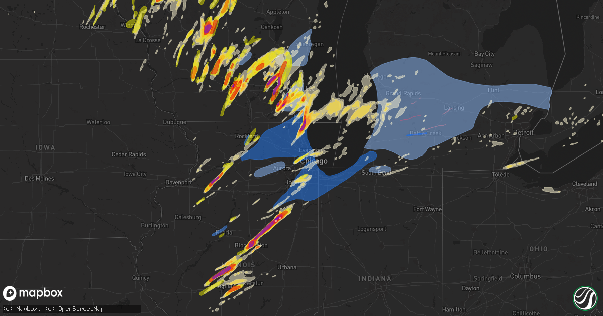
Hail Map on May 15, 2025
Get this storm
May 15 map
$229
one time, instant access
Download today. No call, no setup
Keep the $229
Bought the map and want the full workflow? Apply the entire $229 to a subscription within 7 days. None of it is wasted.
Every map, not just this one
This buys you this map. Subscription and you get every map we run, in the markets you choose from a few cities to whole states to nationwide. Plus real-time alerts the moment a storm fires.
Contact data
Name, contact info, occupancy, even credit band for addresses in the footprint. You go from where it hit to who to call.
Become the source they trust
Unlimited branding weather history reports on demand. You already have the documented answer ready for the property owner, and you are the one who showed up with it.
Property data and RoofTrace estimates
Pull up any address you have got, its value and the exact code rules for that jurisdiction, straight from One Click Code. Then RoofTrace estimates the squares, pitch, and roof value, priced the way you price.
States Impacted by Hail Map on May 15, 2025
Storm reports
Kentucky
| Date | Description |
|---|---|
| 05/15/20256:54 AM CDT | Tree down over kirksville road. |
| 05/15/20256:48 AM CDT | A local report indicates 1.50 inch wind near 5 S Paint Lick |
| 05/15/20256:47 AM CDT | Tree down over sugar creek road at lexington road. |
| 05/15/20256:47 AM CDT | Tree down over sugar creek road at lexington road. (l |
| 05/15/20256:34 AM CDT | A local report indicates 1.00 inch wind near 3 W Junction City |
| 05/15/20256:10 AM CDT | A local report indicates 1.00 inch wind near Lebanon |
| 05/15/20256:06 AM CDT | Report via slack with picture. |
| 05/15/20255:20 AM CDT | Lots of quarter size hail. |
| 05/15/20255:20 AM CDT | Report from mping: quarter |
| 05/15/20255:16 AM CDT | Report from mping: quarter |
| 05/15/20255:15 AM CDT | Nickel to quarter size hail. |
| 05/15/20254:13 AM CDT | Facebook picture. |
| 05/15/20253:15 AM CDT | A local report indicates 1.00 inch wind near 4 SE Sturgis |
North Carolina
| Date | Description |
|---|---|
| 05/15/20256:52 PM CDT | The hail fell several miles east of blounts creek. |
| 05/15/20256:10 PM CDT | A local report indicates 1.00 inch wind near 2 NW Washington |
| 05/15/20255:39 PM CDT | Mping report. |
| 05/15/20255:31 PM CDT | Dominion power reports 130 customers without power due to powerline damage due to winds. |
| 05/15/20255:31 PM CDT | Dominion power reports 130 customers without power due to powerline damage. Possible tornado. |
| 05/15/20255:25 PM CDT | Pictures of tennis ball size hail near stokes was sent by a viewer to wral. |
| 05/15/20255:25 PM CDT | Report of hail up to 1.5 inches near windsor. Time estimated via radar. |
| 05/15/20254:33 PM CDT | Delayed report. Large rv reported turned over near pigum walker park. Possible tornado. |
| 05/15/20254:25 PM CDT | Downed power lines. |
| 05/15/20254:25 PM CDT | Downed power lines. Possible tornado. |
| 05/15/20254:00 PM CDT | Two trees were blown down... One of which fell onto power lines. Time estimated by radar. |
| 05/15/20253:10 PM CDT | Social media report of half dollar sized hail. Time estimated from radar. |
| 05/14/20257:12 PM CDT | Video of 1.5 inch hail in aydlett... Nc. Time estimated via radar. |
| 05/14/20257:12 PM CDT | Video of 1.5 inch hail in aydlet |
Illinois
| Date | Description |
|---|---|
| 05/15/20256:59 PM CDT | Private weather station killelan2 reported 69 mph gust north of leland. |
| 05/15/20256:59 PM CDT | Mesonet station ur707 broadwell. |
| 05/15/20256:59 PM CDT | A local report indicates 60 MPH wind near Mclean |
| 05/15/20256:57 PM CDT | Private weather station reported 58 mph gust near wonder lake. |
| 05/15/20256:55 PM CDT | Public report of golf ball size hail near winthrop harbor. Relayed via mping. |
| 05/15/20256:54 PM CDT | Multiple public reports of hail up to 2 inches in diameter in winthrop harbor. |
| 05/15/20256:50 PM CDT | Public report of quarter size hail on the west side of zion. Time estimated by radar. |
| 05/15/20256:49 PM CDT | A local report indicates 1.00 inch wind near NWS Lincoln |
| 05/15/20256:48 PM CDT | A local report indicates 1.75 inch wind near 1 W Lincoln |
| 05/15/20256:48 PM CDT | Report from mping: quarter |
| 05/15/20256:47 PM CDT | Delayed report. Photos show a farm outbuilding completely destroyed... Power poles down... And sheet metal strewn about the property. A damage survey may be needed in t |
| 05/15/20256:45 PM CDT | Il-dot weather station north of marengo reported 65 mph gust. |
| 05/15/20256:44 PM CDT | Public report of quarter size hail in northern waukegan. |
| 05/15/20256:43 PM CDT | A large tree was split with half of the tree falling over. Golf ball sized hail also occurred around this time. Time estimated by radar. |
| 05/15/20256:43 PM CDT | A local report indicates 1.75 inch wind near Broadwell |
| 05/15/20256:43 PM CDT | Corrects loca |
| 05/15/20256:43 PM CDT | Corrects location on previous report from broadwell. |
| 05/15/20256:42 PM CDT | Trained spotter reported 2 inch hail on the west side of gurnee. |
| 05/15/20256:41 PM CDT | A local report indicates 1.00 inch wind near 5 W Washburn |
| 05/15/20256:41 PM CDT | A local report indicates 1.75 inch wind near 1 W Waukegan |
| 05/15/20256:41 PM CDT | Trained spotter reports 16 inch diameter tree broken west of kingston. Time estimated by radar. |
| 05/15/20256:40 PM CDT | Private weather station reported 59 mph gust north of sycamore. |
| 05/15/20256:40 PM CDT | Trained spotter reports measured 67 mph gust east of genoa. |
| 05/15/20256:40 PM CDT | Trained spotter reported quarter size hail on the south side of gurnee. Time estimated by radar. |
| 05/15/20256:38 PM CDT | Trees down. Social media report. |
| 05/15/20256:38 PM CDT | Delayed report on social media with the time estimated by radar. A photo was provided. |
| 05/15/20256:38 PM CDT | Delayed report on social media with the time estimated by radar. A photo was provided. |
| 05/15/20256:38 PM CDT | Significant damage to a home. Power line down nearby. |
| 05/15/20256:38 PM CDT | A local report indicates 1.50 inch wind near Elkhart |
| 05/15/20256:37 PM CDT | Corrects previous storm surge report from 1 s antioch. Trained spotter reports estimated 2.5 foot diameter tree broken and has fallen onto house. Time estimated by rada |
| 05/15/20256:36 PM CDT | Several photos relayed via social media of tree damage in and around dekalb. One photo showed a 1 foot in diameter tree snapped midway up. Live webcams at the time the |
| 05/15/20256:35 PM CDT | Report of two semi trucks blown over on i-155 near mile marker 3. Report was relayed by emergency manager and time was estimated by radar. |
| 05/15/20256:31 PM CDT | Public report of quarter size hail in belvidere. |
| 05/15/20256:31 PM CDT | Pictures received of a large tree down on a home causing damage to the siding on the back of the home in addition to the gutters and part of the roof. Time estimated fr |
| 05/15/20256:30 PM CDT | Numerous trees damaged... Along with some outbuildings. Time estimated from radar. |
| 05/15/20256:29 PM CDT | Time estimated by radar. |
| 05/15/20256:27 PM CDT | Ping pong ball size hail at the city park. |
| 05/15/20256:27 PM CDT | A local report indicates 1.00 inch wind near Athens |
| 05/15/20256:27 PM CDT | Scattered tree damage occurred throughout town. |
| 05/15/20256:26 PM CDT | Wind-driven hail damage to a residence north of athens. |
| 05/15/20256:25 PM CDT | Public report of small branches broken in vernon hills. Time estimated by radar. |
| 05/15/20256:25 PM CDT | 10 inch tree branch snapped. Time estimated by radar. |
| 05/15/20256:24 PM CDT | Private weather station kilroche34 reported 60 mph gust north of rochelle. |
| 05/15/20256:24 PM CDT | Private weather station kilroche3 reported 60 mph gust between rochelle and hillcrest. |
| 05/15/20256:23 PM CDT | Public report of tree damage between mchenry and volo. Time estimated by radar. |
| 05/15/20256:23 PM CDT | Sign blown over on highway 97 near hurie avenue... And farm shed destroyed on hurie avenue west of highway 97. |
| 05/15/20256:22 PM CDT | A local report indicates 60 MPH wind near 3 NW Peoria |
| 05/15/20256:22 PM CDT | Private weather station reported 64 mph gust northeast of rochelle. |
| 05/15/20256:20 PM CDT | A local report indicates 1.00 inch wind near Bartonville |
| 05/15/20256:15 PM CDT | Trained spotter reports branches 3-4 inch diameter broken. Time estimated by radar. |
| 05/15/20256:00 PM CDT | Several power poles leaning over onto the road resulting in power outages in the city. Photo submitted via social media... But location and damage confirmed by em. Time |
| 05/15/20255:42 PM CDT | Several quarter size stones... Some perhaps bigger. |
| 05/15/20255:42 PM CDT | Corrects previous hail report from 2 w deer grove. Many quarter size stones... But had a few close to golf balls. |
| 05/15/20255:38 PM CDT | Damage to house siding and windows... As well as cracking of a vehicle wind shield. Time estimated by radar. |
| 05/15/20255:25 PM CDT | Photo of several hailstones estimated to be around golf ball size shared via social media. Time estimated by radar. |
| 05/15/20255:06 PM CDT | Public report of quarter size hail near caledonia. Relayed by broadcast media. Time estimated by radar. |
| 05/15/20255:05 PM CDT | Mostly smaller stones... But had a few quarters. |
| 05/15/20255:05 PM CDT | Mostly sm |
| 05/15/20255:05 PM CDT | Relayed from galva city esda. |
| 05/15/20255:05 PM CDT | Relayed from galva city esda. |
| 05/15/20254:52 PM CDT | Powerlines down at the junction of sand road and garden plain road south of fulton. Time estimated by radar. |
| 05/15/20254:46 PM CDT | Rockford airport asos krfd recorded brief gust to 60 mph. |
| 05/14/20258:53 PM CDT | Asos station kcmi willard arpt. |
| 05/14/20258:29 PM CDT | Private weather station kilbeech29 reported 65 mph gust northeast of beecher. |
| 05/14/20258:27 PM CDT | Tree down over the road at springfield ave and state st... Relayed by broadcast media. Time was estimated with radar. |
| 05/14/20258:25 PM CDT | Steger ema reports damage to trees and damage to at least one residence. Time estimated by radar. |
| 05/14/20258:24 PM CDT | Damage to power lines and tree branches near crete. Relayed via will county ema. Time estimated by radar. |
| 05/14/20258:23 PM CDT | Raws weather station at midewin tallgrass prairie reported 59 mph gust. |
| 05/14/20258:20 PM CDT | Multiple reports of downed trees and tree limbs across the south chicago heights... Chatham... And cheltenham neighborhoods of chicago. Data collected from 311 request |
| 05/14/20258:20 PM CDT | A local report indicates 72 MPH wind near 1 E Burbank |
| 05/14/20258:19 PM CDT | Private weather station kiloakfo13 reported 68 mph gust at oak forest. |
| 05/14/20258:18 PM CDT | Monee ema reports tree and power line damage along timber lane west near monee. Time estimated by radar. Ed from radar. |
| 05/14/20258:18 PM CDT | Monee ema reports tree and power line damage along timber lane west near monee. Time estimated by radar. |
| 05/14/20258:17 PM CDT | Private weather station kilpeoto1 reported 62 mph gust. |
| 05/14/20258:17 PM CDT | Large tree branches downed in posen. Time estimated from radar. |
| 05/14/20258:15 PM CDT | Photos shared showing a tree snapped at its base in kennedy park in chicago. Time estimated from radar. |
| 05/14/20258:15 PM CDT | Multiple reports of downed trees and tree limbs across the evergreen park... Beverly... Mount greenwood... Washington heights... And morgan park neighborhoods of chicag |
| 05/14/20258:15 PM CDT | Photos showed on social media of large tree across roadway and on cars. The core of the tree appeared to be rotten. Time estimated by radar. |
| 05/14/20258:14 PM CDT | Multiple reports of trees snapped or uprooted in oak forest. Time estimated from radar. |
| 05/14/20258:13 PM CDT | Picture received of a large tree limb down in the road at the intersection of 151st street and kildare avenue. Time estimated from radar. |
| 05/14/20258:12 PM CDT | Report of a panel of a fence down near the intersection of 152nd street and kostner avenue. Time estimated from radar. |
| 05/14/20258:10 PM CDT | Pictures of snapped trees at beverly and morgan park on the south side of chicago related via social media. Time estimated by radar. |
| 05/14/20258:10 PM CDT | Photo shared on social media of 10 inch in diameter tree snapped. |
| 05/14/20258:10 PM CDT | Multiple reports of downed trees and tree limbs across the cornell... Cheltenham... And south chicago heights neighborhoods of chicago. Data collected from 311 request |
| 05/14/20258:08 PM CDT | Public report of 3 inch diameter branch broken near frankfort. Time estimated by radar. |
| 05/14/20258:07 PM CDT | Video shared to social media shows small branches broken near 45th and leamington avenue in garfield ridge community area of chicago. Time estimated by radar. |
| 05/14/20258:06 PM CDT | Photo of leaning power poles at 175th and harlem in tinley park. Time estimated by radar. |
| 05/14/20258:05 PM CDT | Multiple reports of downed trees and tree limbs across the beverly... Mount greenwood... Washington heights... And morgan park neighborhoods of chicago. Data collected |
| 05/14/20258:05 PM CDT | Several trees downed in palos heights. Time estimated from radar. |
| 05/14/20258:05 PM CDT | Video shared to social media shows small branch broken near 51st and mcvicker in garfield ridge community area of chicago. Time estimated by radar. |
| 05/14/20258:05 PM CDT | Via social media... Person posted pics of numerous branches down in backyard. |
| 05/14/20258:04 PM CDT | Photo shared to social media shows damage to roof trim and gutters of house near 167th and oak park avenue in tinley park. Time estimated by radar. |
| 05/14/20258:03 PM CDT | Public report of quarter size hail in uptown area of chicago. Relayed via mping. |
| 05/14/20258:03 PM CDT | Public report of large tree branches broken near 102nd street and alice court in oak lawn. Time estimated by radar. |
| 05/14/20258:03 PM CDT | Public report of a 8 foot diameter tree downed in oak lawn. Time estimated by radar radar. |
| 05/14/20258:03 PM CDT | Public report |
| 05/14/20258:03 PM CDT | Private weather station kilmanha51 reported 64 mph gust south of manhattan. |
| 05/14/20258:03 PM CDT | Reports of a downed power line as well as extensive downed tree branches along 159th street in tinley park. Time estimated by radar. |
| 05/14/20258:01 PM CDT | Power lines down and most of town without power. |
| 05/14/20258:01 PM CDT | Trained spotter reports 3-4 inch diameter branches broken... Power lines damaged... Trees snapped... And possible roof damage near sweedler road and gougar road in manh |
| 05/14/20258:01 PM CDT | Three gusts in excess of 70 mph measured on home weather station. The peak gust was 73.6 mph. |
| 05/14/20258:00 PM CDT | Via social media... User posted an image of a hail stone next to a ruler measuring 1 inch. |
| 05/14/20258:00 PM CDT | Public works reported snapped 14 diameter branch on crawford street. |
| 05/14/20258:00 PM CDT | Public report of a large tree snapped in the edgewater area of chicago. |
| 05/14/20258:00 PM CDT | Private weather station kilchica577 reported 59 mph gust. |
| 05/14/20257:59 PM CDT | Public report of half dollar size hail near homer glen. Relayed via mping. |
| 05/14/20257:59 PM CDT | Public report of half dollar size hail near homer glen. R |
| 05/14/20257:57 PM CDT | Large tree and wires down across the road report was relayed by local law enforcement. Time was estimated by radar. |
| 05/14/20257:57 PM CDT | Report of a telephone pole broken and wires down was relayed by local law enforcement. Time was estimated by radar. |
| 05/14/20257:57 PM CDT | Wires down was relayed by local law enforcement. Time was estimated by radar. |
| 05/14/20257:54 PM CDT | Private weather station kilchica929 reported 59 mph gust. |
| 05/14/20257:52 PM CDT | Photo shared to social media shows numerous large branches broken near kennedy expressway |
| 05/14/20257:52 PM CDT | Numerous reports of tree damage in and near wilmington. Fascia damage reported to a house as well. Time estimated from radar. |
| 05/14/20257:52 PM CDT | Photo shared of a 2 foot in diameter tree uprooted in the andersonville neighborhood of chicago. Several other reports of downed trees were received in the same general |
| 05/14/20257:52 PM CDT | Photo shared to social media shows large section of roof material blown into a street in the business district of wilmington. Time estimated by radar. |
| 05/14/20257:52 PM CDT | Photo showing the roof above the front porch of a house partially collapsed in lakewood shores. Time estimated from radar. |
| 05/14/20257:52 PM CDT | Private weather station reported 60 mph gust in jefferson park area of chicago. |
| 05/14/20257:50 PM CDT | Fascia peeled off of house in essex. Time estimated from radar. |
| 05/14/20257:47 PM CDT | Photo shared via social media shows roof and walls peeled from metal farm building along n 3500 e road west of cabery. Debris blown into a fiel |
| 05/14/20257:47 PM CDT | Brick chimney of house demolished in braidwood. Time estimated from radar. |
| 05/14/20257:47 PM CDT | Photo shared via social media shows roof and walls peeled from metal farm building along n 3500 e road west of cabery. Debris blown into a field. Time estimated by rada |
| 05/14/20257:46 PM CDT | Large tree branch broken east of decatur... And power lines down. Time estimated from radar. |
| 05/14/20257:46 PM CDT | Multiple trees and large tree limbs downed in the portage park community area of chicago. Time estimated from radar. |
| 05/14/20257:46 PM CDT | Corrects previous report from braceville. Public report of possible damage to tree branches and siding of a building near braceville. Time estimated by radar. |
| 05/14/20257:46 PM CDT | Numerous trees and power lines down. 5-6 homes with trees down onto roofs and several with shingle damage. |
| 05/14/20257:46 PM CDT | Public report of possible damage to tree branches and siding of a building near braceville. Time estimated by radar. |
| 05/14/20257:45 PM CDT | Multiple reports of downed trees and tree limbs across the norwood park neighborhood of chicago. Data collected from 311 request map. Time estimated by radar. |
| 05/14/20257:45 PM CDT | Photo shared to social media shows large tree snapped at the base and damage to at least one nearby car in dunning community area of chicago. Time estimated by radar. |
| 05/14/20257:45 PM CDT | Photo showing large tree limb downed onto canfield avenue at talcott road. Time estimated from radar. |
| 05/14/20257:44 PM CDT | Multiple wind gusts in excess of 75 mph with a peak gust of 78.7 mph. |
| 05/14/20257:44 PM CDT | Photo shared to social media shows baseball size hail near emington. Time estimated by radar. |
| 05/14/20257:44 PM CDT | Photo shared to social media shows baseball size hail near eming |
| 05/14/20257:43 PM CDT | Report shared via social media indicates tree damage near belmont avenue and lincoln street in franklin park. Time estimated by radar. |
| 05/14/20257:43 PM CDT | Power lines down and large tree branch broken off on west side of decatur. |
| 05/14/20257:41 PM CDT | Photo shows 3 inch diameter hail near il-47 and e 2100 n road north of saunemin. Time estimated by radar. Report relayed by broadcast media. |
| 05/14/20257:40 PM CDT | Delayed report. Power poles blown down. Time estimated by radar. |
| 05/14/20257:40 PM CDT | Delayed report. Power poles blown down. Time estimated by radar. |
| 05/14/20257:40 PM CDT | Trained spotter reports hail up to half dollar size near franklin park. |
| 05/14/20257:40 PM CDT | Delayed report. Power poles blown down. Time estimated by radar. |
| 05/14/20257:39 PM CDT | Photo shared via social media shows tennis ball size hail near saunemin. Time estimated by radar. |
| 05/14/20257:38 PM CDT | Time estimated from radar. |
| 05/14/20257:38 PM CDT | Photos relayed via social media depict trees around 1 to 2 feet in diameter downed on power lines in gardner. Time estimated by radar. |
| 05/14/20257:37 PM CDT | Public report of half dollar hail in elmhurst. Relayed via mping. |
| 05/14/20257:37 PM CDT | Public report of quarter size hail in villa park. Relayed via mping. |
| 05/14/20257:37 PM CDT | Public report of half dollar hail in elmhurst. |
| 05/14/20257:35 PM CDT | Trees downed in villa park. Wind-driven quarter size hail also caused damage to siding on house. Time estimated from radar. |
| 05/14/20257:34 PM CDT | Large tree branches and limbs snapped off trees in dwight. Time estimated from radar. |
| 05/14/20257:33 PM CDT | Photo showing uprooted tree in lombard. Time estimated from radar. |
| 05/14/20257:33 PM CDT | 12 telephone poles downed and there is damage to a nearby solar farm. |
| 05/14/20257:30 PM CDT | Tree uprooted. Social media report. Time estimated from radar. |
| 05/14/20257:30 PM CDT | Trained spotter reports downed traffic light near finley road and eisenhower lane in lombard. Time estimated by radar. |
| 05/14/20257:30 PM CDT | Photo on social media of hail stone reported in glen ellyn next to ruler. Time estimated by users post. |
| 05/14/20257:28 PM CDT | Time estimated from radar. |
| 05/14/20257:27 PM CDT | Hail from quarter to golf ball size. Social media report. |
| 05/14/20257:25 PM CDT | Hail this fell for approximately two minutes. |
| 05/14/20257:25 PM CDT | Hail this size fell for approximately two minutes. |
| 05/14/20257:23 PM CDT | A local report indicates 1.75 inch wind near Chenoa |
| 05/14/20257:22 PM CDT | Estimated from pictures posted on social media. |
| 05/14/20257:20 PM CDT | Mesonet station fw2710 towanda. |
| 05/14/20257:20 PM CDT | Along highway 29 between rochester and berry. Social media report. |
| 05/14/20257:18 PM CDT | A local report indicates 65 MPH wind near 3 WSW Chenoa |
| 05/14/20257:15 PM CDT | 4 power poles down east of mechanicsburg. Time estimated from radar. |
| 05/14/20257:15 PM CDT | Photo shared to social media shows small tree snapped in port barrington. Time estimated by radar. |
| 05/14/20257:11 PM CDT | A local report indicates 1.00 inch wind near 3 N Shirley |
| 05/14/20257:11 PM CDT | Report from mping: golf ball |
| 05/14/20257:11 PM CDT | A local report indicates 1.00 inch wind near 1 E Normal |
| 05/14/20257:10 PM CDT | A local report indicates 1.50 inch wind near 1 SW Normal |
| 05/14/20257:08 PM CDT | Corrects location of previous report from 2 e central illinois airport. |
| 05/14/20257:08 PM CDT | A local report indicates 1.75 inch wind near Normal |
| 05/14/20257:08 PM CDT | A local report indicates 1.75 inch wind near 1 W Bloomington |
| 05/14/20257:08 PM CDT | A local report indicates 2.00 inch wind near 2 E Central Illinois Ai |
| 05/14/20257:08 PM CDT | Report from mping: half dollar |
| 05/14/20257:06 PM CDT | A local report indicates 1.00 inch wind near 2 NNW Central Illinois |
| 05/14/20257:06 PM CDT | Social media report with photo provided measuring the hail with a ruler. Time estimated by radar. |
| 05/14/20257:06 PM CDT | A local report indicates 1.00 inch wind near Normal |
| 05/14/20257:05 PM CDT | Report from mping: quarter |
| 05/14/20257:05 PM CDT | Delayed report on social media with the time estimated by radar. A photo was provided. |
| 05/14/20257:05 PM CDT | Report from mping: quarter |
| 05/14/20257:05 PM CDT | Photo provided measuring the hail. Time estimated by radar. |
| 05/14/20257:05 PM CDT | A local report indicates 1.00 inch wind near Bloomington |
| 05/14/20257:04 PM CDT | Private w |
| 05/14/20257:04 PM CDT | Report from mping: golf ball |
| 05/14/20257:04 PM CDT | Private weather station killakev22 reported 62 mph gust near fox lake hills. |
| 05/14/20257:03 PM CDT | Report from mping: half dollar |
| 05/14/20257:03 PM CDT | A local report indicates 1.25 inch wind near 3 SW Bloomington |
| 05/14/20257:02 PM CDT | A local report indicates 1.00 inch wind near 3 N Shirley |
| 05/14/20257:02 PM CDT | Photo shared showing an uprooted tree in spring grove. Fencing was also blown over at the same residence. Time estimated from radar. |
| 05/14/20257:00 PM CDT | A local report indicates 1.00 inch wind near 3 NE Shirley |
Ohio
| Date | Description |
|---|---|
| 05/15/20254:09 AM CDT | Corrects previous hail report from 4 ese south amherst. |
| 05/15/20254:02 AM CDT | Large trees and power lines down. Pea sized hail al |
| 05/15/20254:02 AM CDT | Large trees and power lines down. Pea sized hail also occurred. Time estimated from radar. |
| 05/15/20254:00 AM CDT | Estimated 60 mph wind and small branches down. |
Indiana
| Date | Description |
|---|---|
| 05/15/20256:30 AM CDT | Public emailed ops account with report accompanied by picture verifying quarter size hail. |
| 05/14/202510:55 PM CDT | Awos station kekm elkhart municipa. |
| 05/14/20259:05 PM CDT | Trees down. One reportedly on a mobile home. Time estimated by radar. |
| 05/14/20259:05 PM CDT | Delayed report of large tree downed on mobile home. Time estimated from radar. |
| 05/14/20259:04 PM CDT | Received photos of tree limbs down. Time estimated by radar. |
| 05/14/20258:59 PM CDT | Private weather station kinwheel1 reported 61 mph gust near wheeler. |
| 05/14/20258:50 PM CDT | Photo shared to social media shows possible damage to a shed on the north side of crown point. Time estimated by radar. |
| 05/14/20258:46 PM CDT | Large trees down at bailly elementary school. Time estimated by radar. |
| 05/14/20258:43 PM CDT | Photo shared to social media shows large branches broken in portage. Time estimated by radar. |
| 05/14/20258:42 PM CDT | Roads have been closed due to trees being down. Power outages across the city resulting in heavy traffic due to street lights being out. Stores are closed. Time estimat |
| 05/14/20258:40 PM CDT | Photos shared showing several shingles and other small portions of roofing material peeled off of house. |
| 05/14/20258:36 PM CDT | Trees down and power outages in gary around 71st avenue. Time estimated by radar. |
| 05/14/20258:35 PM CDT | Private weather station reported 66 mph gust near cedar lake. |
| 05/14/20258:33 PM CDT | 4-5 foot maple tree uprooted at north main street and franciscan drive. |
| 05/14/20258:33 PM CDT | Public email photos of a snapped tree in merrillville. Time estimated by radar. |
Minnesota
| Date | Description |
|---|---|
| 05/15/20256:45 PM CDT | Trees down from facebook post with pictures. |
| 05/15/20256:40 PM CDT | Video report courtesy of northern news now of numerous spruce trees... Approximately 10-15... Snapped near the base. Time estimated from radar. |
| 05/15/20256:40 PM CDT | Trees down along and across highway 61 between ionas beach and east beaver bay. Also trees down in silver bay. Facebook picture of tree across highway 61. |
| 05/15/20255:09 PM CDT | Polk county sheriffs office relayed report from on duty deputy of tornado east of crookston. Time and location estimated from radar. |
| 05/15/20255:05 PM CDT | Damage to playset... Via social media. |
| 05/15/20254:35 PM CDT | Photo sent in of two 20 inch diameter white spruce trees snapped 4 to 6 feet off the ground. Spotter notes that the downed trees took out nearby power lines. Time of re |
| 05/15/20254:30 PM CDT | Damage to playset... Social media report. |
| 05/15/20254:25 PM CDT | Tree limbs down... Social media report. |
| 05/15/20254:17 PM CDT | Trees down... Time estimated from radar. |
| 05/15/20254:08 PM CDT | Trees uprooted. |
| 05/15/20254:05 PM CDT | Picture of a mangled road sign from social media. |
| 05/15/20254:02 PM CDT | Trees across highway 34... Time estimated from radar. |
| 05/15/20254:02 PM CDT | Large trees daamged. |
| 05/15/20253:56 PM CDT | Awos station ktvf thief river falls ap mn. |
| 05/15/20253:50 PM CDT | Power outages grundy il 4119 8830 photos relayed via social media depict trees around 1 to 2 feet in diameter downed on power lines in gardner. |
| 05/15/20253:50 PM CDT | Power outages as a result of trees on powerlines nw of red lake falls. |
| 05/15/20253:47 PM CDT | Corrects previous tstm wnd dmg report from 1 w wadena. Large trees snapped. |
| 05/15/20253:47 PM CDT | Large trees snapped. |
| 05/15/20253:40 PM CDT | Substantial wind damage east of perham via social media report. |
| 05/15/20253:37 PM CDT | Corrects previous tstm wnd dmg report from 1 ssw wadena. Corrects previous tstm wnd dmg report from 1 w wadena. Large trees snapped. |
| 05/15/20253:35 PM CDT | Reported from steels nursery. |
| 05/15/20253:32 PM CDT | Several big trees down... Some cattle sheds blown down... And a semi blown over on hwy 10. |
| 05/15/20253:25 PM CDT | Wind gust measured by 33ft ndawn sensor. |
| 05/15/20253:20 PM CDT | Branches down with siding and shingle damage to house. |
| 05/15/20253:05 PM CDT | Multiple large tree limbs down. |
| 05/15/20253:02 PM CDT | Corrects previous tstm wnd gst report from 1 nw underwood. Wind gust measured by 33ft ndawn sensor. |
| 05/15/20253:00 PM CDT | Photo via email. |
| 05/15/20253:00 PM CDT | Mesonet station 211549 eldred mn ndawn. |
| 05/15/20252:58 PM CDT | A local report indicates 1.00 inch wind near 2 ESE Winona |
| 05/15/20252:57 PM CDT | Report from mping: quarter |
| 05/15/20252:57 PM CDT | Near the east end rec center. |
| 05/15/20252:56 PM CDT | Picture via social media. |
| 05/15/20252:55 PM CDT | Awos station kd39 sauk centre ap. |
| 05/15/20252:54 PM CDT | Corrects previous tstm wnd gst report from 2 w eldred. Mesonet station 211549 eldred mn ndawn. |
| 05/15/20252:47 PM CDT | Debris reported |
| 05/15/20252:43 PM CDT | Delayed report... Time estimated from radar. Powerlines down in blaine. |
| 05/15/20252:37 PM CDT | Report from mping: quarter |
| 05/15/20252:27 PM CDT | Corrects previous for wrong date. Tstm wnd dmg report from 2 s audubon. Large branches cracked off trees and east side of pump house lost most shingles. Time estimated |
| 05/15/20251:46 PM CDT | Delayed report... Time estimated from radar. Three large trees down near howard lake.... |
| 05/15/20251:40 PM CDT | Debris reported. |
| 05/15/20251:38 PM CDT | Debris visible. |
| 05/15/20251:16 PM CDT | Location estimated based on spotter report. Time is approximate. Photo provided. |
| 05/14/20257:40 PM CDT | Medium to large spruce tree partially blocking sawbill trail. Time estimated from radar. |
| 05/14/20257:40 PM CDT | Several medium trees |
| 05/14/20257:21 PM CDT | 2 trees down on power lines. |
| 05/14/20257:19 PM CDT | 1 tree down on powerline... Powerline down fully blocking the road. |
Michigan
| Date | Description |
|---|---|
| 05/15/202510:09 AM CDT | Large healthy tree down. Time estimated from radar. |
| 05/15/202512:35 AM CDT | Large tree limb downed. Photo shared via social media. |
| 05/15/202512:26 AM CDT | Trees and power lines reported down in bridgehampton and delaware townships. |
| 05/15/202512:16 AM CDT | Numerous large trees down near mayer rd and rattle run rd. |
| 05/15/202512:11 AM CDT | Large tree downed across roadway. Photo shared via social media. |
| 05/15/202512:10 AM CDT | Tree reported blown down. |
| 05/14/202511:52 PM CDT | Trees sheared and wires down. |
| 05/14/202511:47 PM CDT | Sporadic isolated trees reported down across northwest washtenaw county. |
| 05/14/202511:37 PM CDT | Photo of tree down near usps on e flint st. |
| 05/14/202511:35 PM CDT | Nws damage survey confirmed an ef-0 tornado touched down northeast of atlas and was on the ground 3 minutes before lifting north of goodrich. |
| 05/14/202511:33 PM CDT | Photos of trees down and large branches |
| 05/14/202511:32 PM CDT | Damage reported south of the eaton rapids area near m-50 from holmes highway to bellevue highway. |
| 05/14/202511:27 PM CDT | A swath of uprooted trees and trees down from downtown holly to holly village mobile home park. Peak winds estimated up to 70 mph. |
| 05/14/202511:27 PM CDT | Report of two large trees down |
| 05/14/202511:24 PM CDT | A local report indicates 59 MPH wind near Flint Bishop Intl Airpo |
| 05/14/202511:23 PM CDT | Jackson county emergency manager reports two homes sustained structural damage from falling trees in liberty township. Another home had window and siding damage. A crus |
| 05/14/202511:20 PM CDT | Report of trees and wires down |
| 05/14/202511:18 PM CDT | Several large tree limbs down. |
| 05/14/202511:18 PM CDT | Report of trees and wires down |
| 05/14/202511:10 PM CDT | Tree down on byron rd near cohoctah. |
| 05/14/202511:10 PM CDT | Outbuilding damage and power pole damage. |
| 05/14/202511:05 PM CDT | Trees down and a barn suffered damage... Which included parts of the roof. Wind damage occured as prior confirmed tornado dissipated. |
| 05/14/202511:05 PM CDT | Shingles and roofing partially removed from home. Tree damage on property. Wnem report. Time estimated from radar. |
| 05/14/202511:05 PM CDT | Nws damage survey confirmed an ef-0 tornado touched down just west of st charles and was on the ground for 5 minutes before lifting in st charles. |
| 05/14/202511:03 PM CDT | Nws damage survey confirmed a brief ef-1 tornado touched down between stockbridge and gregory being on the ground for a couple minutes before gusting out over gregory. |
| 05/14/202511:02 PM CDT | Report of trees and wires down |
| 05/14/202510:46 PM CDT | Semi truck flipped over on us 127 near barnes st south of mas |
| 05/14/202510:46 PM CDT | Report of trees and wires down |
| 05/14/202510:46 PM CDT | Numerous trees snapped and fallen in okemos. Wlns report. Time estimated from radar. |
| 05/14/202510:46 PM CDT | A few trees down off kensington rd. |
| 05/14/202510:46 PM CDT | Semi truck flipped over on us 127 near barnes st south of mason. Time estimated from radar. |
| 05/14/202510:46 PM CDT | Multiple trees down. |
| 05/14/202510:46 PM CDT | Semi truck flipped over on us 127 near barnes st south of mason. Time estimated f |
| 05/14/202510:43 PM CDT | Tree on house. |
| 05/14/202510:42 PM CDT | Lansing asos. |
| 05/14/202510:40 PM CDT | Spotter reports power flashes near the meijer distribution center off creyts rd. Tornado debris signature on radar. |
| 05/14/202510:40 PM CDT | Multiple trees down. |
| 05/14/202510:39 PM CDT | Video of structural damage to the gm facility off mt. Hope highway in lansing. A large section of a wall was removed... Exposing the inside of the facility. Time estima |
| 05/14/202510:36 PM CDT | Semi truck overturned on millet highway between south canal rd and south creyts rd. Location is within the tornado debris signature on radar. Time is appro |
| 05/14/202510:36 PM CDT | Structural damage to business with wall removed and debris blown into vehicles. Wlns report. Time estimated from radar. |
| 05/14/202510:36 PM CDT | Semi truck overturned on millet highway between south canal rd and south creyts rd. Location is within the tornado debris signature on radar. Time is approximate. |
| 05/14/202510:35 PM CDT | Awos station khai three rivers. |
| 05/14/202510:32 PM CDT | Report of multiple mature trees down and broken branches 2 blocks north and west of capitol ave and columbia ave. |
| 05/14/202510:30 PM CDT | Emergency manager reports tree limbs and powerlines down from three rivers to mendon. Time estimated via radar. |
| 05/14/202510:30 PM CDT | Emergency manager reports trees and power lines down from three river to mendon. Time estimated via radar. |
| 05/14/202510:28 PM CDT | Numerous trees down... Multiple trees on houses. |
| 05/14/202510:27 PM CDT | Trees and wires down. Tree across roadway. |
| 05/14/202510:25 PM CDT | Tree and structure damage occurred along the path of this ef1 tornado. A number of homes had roofing material ripped away and several outbuildings were heavily damaged. |
| 05/14/202510:23 PM CDT | Damage along w baseline highway near pine lake. Barn roof removed... Power lines down... And trees down. Time estimated from radar. |
| 05/14/202510:23 PM CDT | Roof removed from barn and tree damage on property. Woodtv report. Time estimated from radar. |
| 05/14/202510:16 PM CDT | Barn damaged. Woodtv report. Time estimated. |
| 05/14/202510:16 PM CDT | Trees snapped with multiple trees across roads. |
| 05/14/202510:13 PM CDT | Trees down across road. Time estimated. |
| 05/14/202510:13 PM CDT | Wires down. Time estimated. |
| 05/14/202510:13 PM CDT | Several uprooted trees along w tuttle rd. |
| 05/14/202510:11 PM CDT | The ef0 tornado resulted in mostly tree damage along its 8.5 mile path. It began just west of saint marys lak |
| 05/14/202510:11 PM CDT | The ef0 tornado resulted in mostly tree damage along its 8.5 mile path. It began just west of saint marys lake and traveled just south of the lake and remained very clo |
| 05/14/202510:10 PM CDT | Several trees down at hubbard st and waubascon rd. Time estimated. |
| 05/14/202510:10 PM CDT | Boat flipped on fine lake... Southeast of delton. Woodtv report. Time estimated. |
| 05/14/202510:09 PM CDT | Corrects time for vestaburg report. Large healthy tree down. Time estimated from radar. |
| 05/14/202510:09 PM CDT | Peak gust at battle creek asos before going offline. |
| 05/14/202510:07 PM CDT | Kalamazoo asos. |
| 05/14/202510:06 PM CDT | Trees down south of leroy. Time estimated. |
| 05/14/202510:06 PM CDT | Several trees down... 12-20 inch diameter. Time estimated from radar. |
| 05/14/202510:00 PM CDT | Public report of trees down across red arrow highway near s 1st street close to the van buren/kalamazoo county line. |
| 05/14/202510:00 PM CDT | Public report of trees down across red arrow highway near s 1st street close to the va |
| 05/14/202510:00 PM CDT | Delayed report. Two trees uprooted and large tree branches downed. Time estimated from radar. |
| 05/14/202510:00 PM CDT | Shingles torn off roof. |
| 05/14/20259:59 PM CDT | The ef0 tornado resulted in mainly tree damage along its 10 mile path. More concentrated tree damage occurred near the beginning and the end of the path with intermitte |
| 05/14/20259:59 PM CDT | Tree on house near freeport. Woodtv report. Time estimated from radar. |
| 05/14/20259:58 PM CDT | Trees and wires down across road. |
| 05/14/20259:56 PM CDT | Gerald r ford international. |
| 05/14/20259:55 PM CDT | Trees down. |
| 05/14/20259:53 PM CDT | Tree on home. Woodtv report. Time estimated from radar. |
| 05/14/20259:50 PM CDT | Woodtv reports the comerica bank building in downtown kalamazoo had some paneling and insulation removed. Time estimated from radar. |
| 05/14/20259:50 PM CDT | Trees down. Time estimated. |
| 05/14/20259:49 PM CDT | Shingles off of gazebo. |
| 05/14/20259:49 PM CDT | Tree across road. |
| 05/14/20259:47 PM CDT | Boat flipped on gun lake. Woodtv report. |
| 05/14/20259:47 PM CDT | Large tree branch on house... 60th and kalamazoo. Some damage to siding. Woodtv report. Time estimated from radar. |
| 05/14/20259:47 PM CDT | Trees snapped and uprooted in caledonia. Woodtv report. Time estimated from radar. |
| 05/14/20259:44 PM CDT | Tree fell on a vehicle. Woodtv report. Time estimated. |
| 05/14/20259:44 PM CDT | Trees and wires down in the city of big rapids. Pemberton and elm... Mecosta and chestnut streets were impacted. |
| 05/14/20259:41 PM CDT | Schnable lake area west of martin sustained damage with multiple trees snapped or down... At least one boat flipped out of the water... And at least one camper flipped |
| 05/14/20259:41 PM CDT | Corrects previous tstm wnd dmg report from 3 wsw martin. Schnable lake area west of martin sustained damage with at least one camper flipped over. Woodtv report. Time e |
| 05/14/20259:38 PM CDT | Extensive structural damage to house from a falling tree. Woodtv report. Time estimated from radar. |
| 05/14/20259:37 PM CDT | Numerous healthy trees down in dorr township. Time estimated from radar. |
| 05/14/20259:37 PM CDT | Eight large pine trees down on a property in dorr. Location is within a tds on radar. Time is estimated. |
| 05/14/20259:34 PM CDT | Several trees and large limbs down across paw paw. Delayed report. Time estimated via radar. |
| 05/14/20259:28 PM CDT | Reports of large trees downed. Time estimated from radar. |
| 05/14/20259:25 PM CDT | Very large healthy tree snapped. Woodtv report. Time estimated from radar. |
| 05/14/20259:25 PM CDT | Reports of large trees downed. Time estimated from radar. |
| 05/14/20259:25 PM CDT | Asos station kbeh benton harbor. |
| 05/14/20259:23 PM CDT | Corrects time for previous tstm wnd dmg report from 1 n drenthe. Barn destroyed. |
| 05/14/20259:22 PM CDT | A tree snapped at the base and landed on a building... Damaging a deck. |
| 05/14/20259:20 PM CDT | Large 3 foot diameter tree downed onto a house. Time estimated from radar. |
| 05/14/20259:19 PM CDT | Trees down on butternut dr north and south of quincy st near holland. |
| 05/14/20259:13 PM CDT | A local report indicates 61 MPH wind near 1 N Benton Heights |
| 05/14/20259:12 PM CDT | Numerous trees snapped or uprooted across saugatuck and saugatuck township. Woodtv report. Time estimated from radar. |
| 05/14/20259:12 PM CDT | Holland asos. |
| 05/14/20259:07 PM CDT | Several large branches down... Time estimated via radar. Delayed report. |
| 05/14/20259:06 PM CDT | Trees down throughout waukazoo woods. Multiple trees through homes on post avenue and oakwood ave. |
| 05/14/20258:56 PM CDT | A local report indicates 72 MPH wind near 1 NW Norton Shores |
| 05/14/20258:55 PM CDT | Asos station kmkg muskegon county airport. |
| 05/14/20258:54 PM CDT | Spring lake yacht club. Time estimated. |
| 05/14/20258:54 PM CDT | Trees uprooted and siding torn off of home. |
| 05/14/20258:46 PM CDT | Time estimated. |
| 05/14/20258:42 PM CDT | Multiple trees uprooted. |
| 05/14/20258:23 PM CDT | Barn destroyed. |
| 05/14/20257:47 PM CDT | Dispatch reports large tree down at us-45 and himanka hill road. |
| 05/14/20257:30 PM CDT | Dispatch reports several trees down at us-2 and beatons lake road. |
New York
| Date | Description |
|---|---|
| 05/15/20254:56 AM CDT | Report of a few t |
| 05/15/20254:56 AM CDT | Report o |
| 05/15/20254:56 AM CDT | Report of a few trees downed on wires in attica. |
| 05/15/20254:37 AM CDT | Report of a few trees downed in the town of napoli. |
| 05/15/20254:22 AM CDT | Downed power lines on lakewood avenue in buffalo. Time esti |
| 05/15/20254:22 AM CDT | Downed power lines on lakewood avenue in buffalo. Time estimated based on radar. |
| 05/15/20253:45 AM CDT | Large tree down on prospect road in westfield. Time estimated based on radar. |
Oklahoma
| Date | Description |
|---|---|
| 05/15/20257:10 AM CDT | A picture of hail quarter to half dollar size was received by nws shreveport... Via social media... In the areas of sugarberry/grape trail roads in hochatown. |
Wisconsin
| Date | Description |
|---|---|
| 05/15/20256:58 PM CDT | Report from mping: half dollar |
| 05/15/20256:54 PM CDT | Report from mping: quarter |
| 05/15/20256:54 PM CDT | Multiple calls for wires down and some tree damage. No significant damage. |
| 05/15/20256:53 PM CDT | Picture of 2 inch hail. |
| 05/15/20256:51 PM CDT | Report from mping: quarter |
| 05/15/20256:50 PM CDT | A local report indicates 1.50 inch wind near 2 WSW Amherst Junction |
| 05/15/20256:50 PM CDT | Half dollar size hail on the south side of town. |
| 05/15/20256:49 PM CDT | 2 trees down near highway 51. |
| 05/15/20256:47 PM CDT | A local report indicates 1.75 inch wind near 2 NE Pleasant Prairie |
| 05/15/20256:45 PM CDT | Report from mping: quarter |
| 05/15/20256:45 PM CDT | A local report indicates 1.00 inch wind near 1 SW Wausau |
| 05/15/20256:42 PM CDT | Report from mping: quarter |
| 05/15/20256:42 PM CDT | Largest measured. |
| 05/15/20256:41 PM CDT | Report from mping: quarter |
| 05/15/20256:40 PM CDT | Report from mping: ping pong ball |
| 05/15/20256:38 PM CDT | Report from mping: quarter |
| 05/15/20256:36 PM CDT | A local report indicates 1.00 inch wind near 1 N Muskego |
| 05/15/20256:27 PM CDT | Report from mping: half dollar |
| 05/15/20256:26 PM CDT | Report from mping: hen egg |
| 05/15/20256:24 PM CDT | A local report indicates 1.25 inch wind near 2 SE Hartford |
| 05/15/20256:23 PM CDT | Report from mping: quarter |
| 05/15/20256:22 PM CDT | Report from mping: half dollar |
| 05/15/20256:21 PM CDT | Strong winds caused roof damage. |
| 05/15/20256:21 PM CDT | Re |
| 05/15/20256:21 PM CDT | Report from mping: quarter |
| 05/15/20256:20 PM CDT | A local report indicates 1.25 inch wind near 2 E Evergreen |
| 05/15/20256:19 PM CDT | Report from mping: quarter |
| 05/15/20256:15 PM CDT | A local report indicates 1.00 inch wind near 4 NE Green Lake |
| 05/15/20256:15 PM CDT | A local report indicates 1.00 inch wind near 6 S Waupun |
| 05/15/20256:15 PM CDT | Report from mping: quarter |
| 05/15/20256:15 PM CDT | Hail ranging from over 0.5 947 corrects location on previous report from broadwell. |
| 05/15/20256:15 PM CDT | Report from mping: quarter |
| 05/15/20256:15 PM CDT | Hail ranging from over 0.5 inch diameter to larger than 2 inch diameter at times... Lasted approximately 20 minutes. Wind was generally from the west and south... With |
| 05/15/20256:14 PM CDT | Report from mping: tennis ball |
| 05/15/20256:14 PM CDT | Reported by jefferson county sheriff near co hwy p. |
| 05/15/20256:13 PM CDT | Tennis-baseball sized hail causing significant damage to vehicles in far western waterford near walworth county border. |
| 05/15/20256:12 PM CDT | Report from mping: half dollar |
| 05/15/20256:10 PM CDT | Reported golf ball size hail reported from trained. |
| 05/15/20256:10 PM CDT | House siding and roof damage. Reported via x. Fox rd and helena rd. Time estimated from radar. |
| 05/15/20256:10 PM CDT | Report with photo of top half of large spruce tree snapped and down onto the large branch of a nearby tree... All landing near a house. Time estimated. |
| 05/15/20256:09 PM CDT | Report from mping: quarter |
| 05/15/20256:08 PM CDT | Report from mping: quarter |
| 05/15/20256:08 PM CDT | A local report indicates 2.00 inch wind near East Troy |
| 05/15/20256:06 PM CDT | A local report indicates 1.00 inch wind near East Troy |
| 05/15/20256:06 PM CDT | A local report indicates 1.50 inch wind near 4 NNW Bancroft |
| 05/15/20256:05 PM CDT | A local report indicates 1.25 inch wind near Mukwonago |
| 05/15/20256:05 PM CDT | A local report indicates 1.25 inch wind near Mukwonago |
| 05/15/20256:04 PM CDT | A local report indicates 1.25 inch wind near 3 NE Green Lake |
| 05/15/20256:03 PM CDT | Report from mping: half dollar |
| 05/15/20256:01 PM CDT | Turning north onto county hwy j... From hwy 54... I noticed a large funnel cloud with a small column reaching towards the ground. |
| 05/15/20256:01 PM CDT | Numerous reports of tree and outbuilding damage in downtown mayville. Time estimated from radar. |
| 05/15/20256:01 PM CDT | Report of debris along clark street near mayville high school. |
| 05/15/20256:00 PM CDT | A local report indicates 1.50 inch wind near 4 S East Troy |
| 05/15/20256:00 PM CDT | Shredded leaves off of trees... Did not accumulate much. |
| 05/15/20255:57 PM CDT | Brief tornado reported from public via law enforcement. |
| 05/15/20255:55 PM CDT | Raws site measured on hourly observation. Time estimated from radar. Sensor at 6.1 meters. Sse wind direction. |
| 05/15/20255:53 PM CDT | Dodge co sheriff reported roof off house on west hillcrest rd. |
| 05/15/20255:53 PM CDT | Report from mping: quarter |
| 05/15/20255:52 PM CDT | A local report indicates 1.00 inch wind near 3 SSE Hubertus |
| 05/15/20255:51 PM CDT | Report from mping: quarter |
| 05/15/20255:50 PM CDT | Numerous 4 to 12 inch limbs down and power lines down in minnesota junction. Time estimated from radar. |
| 05/15/20255:45 PM CDT | Report from mping: half dollar |
| 05/15/20255:40 PM CDT | Strong winds and rain... 2 balsam trees down. |
| 05/15/20255:40 PM CDT | A local report indicates 1.00 inch wind near 3 S Richfield |
| 05/15/20255:38 PM CDT | A local report indicates 1.50 inch wind near 1 SE Beaver Dam |
| 05/15/20255:38 PM CDT | Wind instrument 90 feet above ground and above the tree tops. |
| 05/15/20255:37 PM CDT | Report from mping: ping pong ball |
| 05/15/20255:37 PM CDT | A local report indicates 1.00 inch wind near 3 NW Reeseville |
| 05/15/20255:35 PM CDT | Quarter size hail covering the ground. |
| 05/15/20255:33 PM CDT | Multiple uprooted trees. Time estimated from radar. |
| 05/15/20255:31 PM CDT | A local report indicates 1.00 inch wind near 1 NW Nashotah |
| 05/15/20255:30 PM CDT | One tree down... Light outside furniture and tools tossed around. Wind shredded apart a tarp garage. Time estimated by spotter. |
| 05/15/20255:30 PM CDT | Tree fell on cabin roof... Twisting and breaking antenna. Time estimated. |
| 05/15/20255:27 PM CDT | Report from mping: quarter . Inch diameter to larger than 2 inch diameter at times... Lasted approximately 20 minutes. Wind was generally from t |
| 05/15/20255:27 PM CDT | Report from mping: quarter |
| 05/15/20255:25 PM CDT | Hail ranged from quarter to half dollar size. |
| 05/15/20255:25 PM CDT | A local report indicates 1.00 inch wind near 1 W Dousman |
| 05/15/20255:21 PM CDT | This tornado developed in fields west of unity before tracking northeast toward colby. As it moved through rural areas of northeastern clark county... It damaged multip |
| 05/15/20255:18 PM CDT | Relayed via x with photo. |
| 05/15/20255:07 PM CDT | Delayed report... Time estimated from radar. Several twisted and moved docks and downed trees near the dairyland reservoir. |
| 05/15/20255:05 PM CDT | Delayed report... Time estimated from radar. Several snapped or leaning power poles along county hwy p. |
| 05/15/20255:05 PM CDT | 6 inch tree down over east bound lane of hwy 70. Road crews are on site removing debris. |
| 05/15/20255:05 PM CDT | Delayed report... Time estimated from radar. Significant structural damage to a house with loss of soffits and roof damage causing the home to be moved slightly. Straig |
| 05/15/20255:04 PM CDT | Delayed report... Time estimated from radar. Multiple reports of trees down and some structural damage. |
| 05/15/20255:04 PM CDT | Pictures of hail to the size of ping pong balls. |
| 05/15/20255:04 PM CDT | Law enforcement reported a tornado on the ground near loyal... Wi. |
| 05/15/20255:02 PM CDT | A local report indicates 1.00 inch wind near 3 SE Palmyra |
| 05/15/20254:58 PM CDT | Report from mping: half dollar |
| 05/15/20254:58 PM CDT | Report from mping: half dollar |
| 05/15/20254:56 PM CDT | Large healthy tree branches snapped off. Some 5-8 inches in diameter. All blown in one direction from south to north. |
| 05/15/20254:55 PM CDT | A few trees knocked down from sudden winds. Lawn furniture tossed and damaged. |
| 05/15/20254:55 PM CDT | This tornado developed in rural areas of clark county... Wi between christie and loyal. As the tornado moved northeast... It damaged multiple trees and removed a portio |
| 05/15/20254:55 PM CDT | Relayed via x with photo. |
| 05/15/20254:51 PM CDT | Relayed via x with photo of hail stone next to a ruler. |
| 05/15/20254:51 PM CDT | A local report indicates 1.75 inch wind near 2 NE Maple Bluff |
| 05/15/20254:50 PM CDT | Report from mping: hen egg+ |
| 05/15/20254:50 PM CDT | Several branches 6 inch diameter broken off trees. Time estimated from radar. |
| 05/15/20254:48 PM CDT | Delayed report... Time estimated from radar. Several downed trees across a broad area west of the holcombe flowage. Estimated wind speeds near 70 mph. |
| 05/15/20254:47 PM CDT | This short-lived tornado snapped the trunks of a few large trees southwest of christie... Wi. The diameter of the largest tree that was snapped was large enough to supp |
| 05/15/20254:45 PM CDT | Photo sent in via social media showing several trees snapped near the trunk or uprooted. Time of report estimated from radar. |
| 05/15/20254:45 PM CDT | Report of multiple birch and aspen trees damaged. These trees were approximately 18 inches in diameter with some uprooted and other snapped. Spotter estimated time of d |
| 05/15/20254:42 PM CDT | Report from mping: half dollar |
| 05/15/20254:40 PM CDT | Delayed report... Time estimated from radar. Downed trees partially blocking the road. |
| 05/15/20254:40 PM CDT | Near the town of seif - size estimated. Via social media. |
| 05/15/20254:40 PM CDT | Report from mping: quarter |
| 05/15/20254:39 PM CDT | Delayed report... Time estimated from radar. Trees down. |
| 05/15/20254:39 PM CDT | A local report indicates 1.00 inch wind near 1 NNE Camp Douglas |
| 05/15/20254:38 PM CDT | Numerous trees down... Power out for 4 hours. |
| 05/15/20254:38 PM CDT | 4 trees down. One large poplar uprooted... One snapped at the base... One snapped midway to the top... And one medium maple. Neighbors had a medium white pine snap 4-6 |
| 05/15/20254:36 PM CDT | A local report indicates 1.00 inch wind near Sun Prairie |
| 05/15/20254:36 PM CDT | A local report indicates 1.00 inch wind near Portage |
| 05/15/20254:35 PM CDT | A local report indicates 1.75 inch wind near 7 NE Baraboo |
| 05/15/20254:34 PM CDT | A local report indicates 1.50 inch wind near 6 SE Lake Delton |
| 05/15/20254:34 PM CDT | A local report indicates 1.50 inch wind near Camp Douglas |
| 05/15/20254:32 PM CDT | Via social media. |
| 05/15/20254:32 PM CDT | A local report indicates 1.00 inch wind near Camp Douglas |
| 05/15/20254:31 PM CDT | Delayed report... Time estimated from radar. Downed powerline. |
| 05/15/20254:31 PM CDT | Several trees down on road. Power lines down. |
| 05/15/20254:30 PM CDT | A local report indicates 1.00 inch wind near 3 SSW Plainville |
| 05/15/20254:30 PM CDT | Several trees on roadway. |
| 05/15/20254:28 PM CDT | Tree blocking 18th street near 22 1/2 ave. |
| 05/15/20254:28 PM CDT | A local report indicates 1.75 inch wind near 3 W Cottage Grove |
| 05/15/20254:28 PM CDT | A local report indicates 1.75 inch wind near 3 W Cottage Grove |
| 05/15/20254:27 PM CDT | Delayed report... Time estimated from radar. Half dozen tall pines snapped. Other tree damage on neighboring property. |
| 05/15/20254:27 PM CDT | 8 inch diameter tree branch downed across a lane of hwy wi 70. Time estimated from radar. |
| 05/15/20254:26 PM CDT | A local report indicates 1.25 inch wind near Arkdale |
| 05/15/20254:26 PM CDT | A local report indicates 1.00 inch wind near Elroy |
| 05/15/20254:25 PM CDT | Damage to siding of a house. Time estimated from radar. |
| 05/15/20254:25 PM CDT | Image via social media. |
| 05/15/20254:25 PM CDT | Only viewable damage right now is to tree canopy. |
| 05/15/20254:25 PM CDT | Report from mping: golf ball |
| 05/15/20254:25 PM CDT | A local report indicates 1.75 inch wind near 1 WNW Arkdale |
| 05/15/20254:24 PM CDT | A local report indicates 1.00 inch wind near Elroy |
| 05/15/20254:23 PM CDT | Report from mping: hen egg |
| 05/15/20254:22 PM CDT | Tree down blocking a lane on us-53. Hail up to nickel size. Wind speed measured with car anemometer of 65-75mph gusts. |
| 05/15/20254:21 PM CDT | Report from mping: quarter |
| 05/15/20254:21 PM CDT | A local report indicates 1.00 inch wind near Mcfarland |
| 05/15/20254:20 PM CDT | Report from mping: half dollar |
| 05/15/20254:20 PM CDT | A local report indicates 1.50 inch wind near 3 W Middleton |
| 05/15/20254:20 PM CDT | Report from mping: quarter |
| 05/15/20254:20 PM CDT | Report from mping: quarter |
| 05/15/20254:20 PM CDT | A local report indicates 2.25 inch wind near 3 NNW Altoona |
| 05/15/20254:20 PM CDT | A local report indicates 1.50 inch wind near Monona |
| 05/15/20254:19 PM CDT | 3 inch diameter hail measured at the weau studios. |
| 05/15/20254:19 PM CDT | Delayed report... Time estimated from radar. Trees down in town. |
| 05/15/20254:18 PM CDT | Email with picture. |
| 05/15/20254:18 PM CDT | Image via social media. |
| 05/15/20254:18 PM CDT | Corrects previous hail report from 3 ssw altoona. Corrects previous hail report from 3 ssw altoona. Measured at the wqow studios. |
| 05/15/20254:18 PM CDT | Report from mping: baseball |
| 05/15/20254:18 PM CDT | A local report indicates 1.75 inch wind near 1 E Adams |
| 05/15/20254:18 PM CDT | A local report indicates 1.00 inch wind near 3 W Middleton |
| 05/15/20254:17 PM CDT | A local report indicates 1.00 inch wind near Alma Center |
| 05/15/20254:16 PM CDT | Report from mping: half dollar |
| 05/15/20254:16 PM CDT | Report from mping: golf ball |
| 05/15/20254:16 PM CDT | Damage to siding reported as well. |
| 05/15/20254:15 PM CDT | A local report indicates 1.00 inch wind near Sparta |
| 05/15/20254:15 PM CDT | Relayed with photo from wqow. |
| 05/15/20254:15 PM CDT | A local report indicates 2.50 inch wind near 1 W Altoona |
| 05/15/20254:15 PM CDT | Relayed with photo by wqow. |
| 05/15/20254:14 PM CDT | Report from mping: golf ball . |
| 05/15/20254:14 PM CDT | Report from mping: golf ball |
| 05/15/20254:12 PM CDT | Report from mping: ping pong ball |
| 05/15/20254:12 PM CDT | A local report indicates 2.00 inch wind near 5 S Altoona |
| 05/15/20254:12 PM CDT | A local report indicates 1.25 inch wind near 1 S Madison |
| 05/15/20254:11 PM CDT | Picture sent via nwschat. |
| 05/15/20254:10 PM CDT | Via social media. |
| 05/15/20254:09 PM CDT | Delayed report... Time estimated from radar. Tree down. |
| 05/15/20254:09 PM CDT | Measured at the wqow studios. |
| 05/15/20254:08 PM CDT | Report from mping: quarter |
| 05/15/20254:08 PM CDT | A local report indicates 1.50 inch wind near 1 W Oregon |
| 05/15/20254:08 PM CDT | Report from mping: ping pong ball |
| 05/15/20254:08 PM CDT | Report from mping: ping pong ball |
| 05/15/20254:08 PM CDT | Report from mping: hen egg |
| 05/15/20254:08 PM CDT | Report from mping: ping pong ball |
| 05/15/20254:08 PM CDT | Report from mping: golf ball |
| 05/15/20254:08 PM CDT | Picture via social media. |
| 05/15/20254:07 PM CDT | Report from mping: ping pong ball |
| 05/15/20254:06 PM CDT | A local report indicates 1.50 inch wind near Fitchburg |
| 05/15/20254:06 PM CDT | Report from mping: quarter |
| 05/15/20254:05 PM CDT | Delayed report... Time estimated from radar. Tree down. |
| 05/15/20254:05 PM CDT | A local report indicates 1.00 inch wind near 2 SSW Altoona |
| 05/15/20254:04 PM CDT | Delayed report... Time estimated from radar. Tree down. |
| 05/15/20254:03 PM CDT | Report from mping: ping pong ball |
| 05/15/20254:02 PM CDT | Relayed by wisc-tv. Photo of large hail stone next to a hen egg. Time estimated from radar. |
| 05/15/20254:01 PM CDT | Via social media. |
| 05/15/20254:00 PM CDT | Possible tornado. Narrow swath of tree damage reported on their and neighboring properties. |
| 05/15/20253:58 PM CDT | Report from mping: quarter |
| 05/15/20253:50 PM CDT | Delayed report... Time estimated from radar. Tree down. |
| 05/15/20253:50 PM CDT | Picture via social media. |
| 05/15/20253:45 PM CDT | Public report via facebook photo. Time estimated via radar. |
| 05/15/20253:43 PM CDT | Photo via nws chat. |
| 05/15/20253:42 PM CDT | A local report indicates 1.00 inch wind near 1 NE Monroe |
| 05/15/20253:40 PM CDT | Delayed report... Time estimated from radar. Part of a roof blown off a shed. |
| 05/15/20253:35 PM CDT | Picture via social media. |
| 05/15/20253:34 PM CDT | Sent photo of ongoing tornado. |
| 05/15/20253:30 PM CDT | Deputy reported a tornado on the ground north of roberts along 110th. |
| 05/15/20253:30 PM CDT | Tornado on the ground 4-5 miles north of house moving nne. |
| 05/15/20253:28 PM CDT | A local report indicates 1.00 inch wind near Ithaca |
| 05/15/20253:25 PM CDT | A local report indicates 1.00 inch wind near 1 NW Spring Green |
| 05/15/20253:24 PM CDT | County road b and post hollow ln. |
| 05/15/20253:18 PM CDT | A local report indicates 1.00 inch wind near Arcadia |
| 05/15/20253:18 PM CDT | A local report indicates 1.00 inch wind near Arcadia |
| 05/15/20253:16 PM CDT | A local report indicates 1.00 inch wind near Centerville |
| 05/15/20253:13 PM CDT | Report relayed from broadcast media. Time estimated from radar. |
| 05/15/20253:07 PM CDT | Via social media. |
| 05/15/20253:05 PM CDT | Delayed report... Time estimated from radar. Tree down. |
| 05/15/20253:02 PM CDT | A local report indicates 1.00 inch wind near Nelson |
| 05/15/20253:01 PM CDT | A local report indicates 1.00 inch wind near 1 W Trempealeau |
| 05/15/20253:00 PM CDT | Delayed report... Time estimated from radar. Multiple trees down. |
| 05/15/20252:57 PM CDT | Picture via social media. |
| 05/14/20257:20 PM CDT | Report from mping: quarter |
| 05/14/20257:11 PM CDT | Southwest wind sustained at 46 mph. |
| 05/14/20257:05 PM CDT | Report from mping: golf ball |
| 05/14/20257:05 PM CDT | Last asos observation before power went out for contract observer at general mitchell international airport. |
| 05/14/20257:04 PM CDT | Grain bins damaged... Semi trailer rolled over. |
| 05/14/20257:03 PM CDT | Batten international airport in racine. |
| 05/14/20257:01 PM CDT | Report from mping: quarter |
| 05/14/20257:01 PM CDT | A local report indicates 1.00 inch wind near 1 S South Milwaukee |
| 05/14/20257:01 PM CDT | Report from mping: quarter |
| 05/14/20257:00 PM CDT | Report from mping: half dollar |
| 05/14/20257:00 PM CDT | Power lines down... Uprooted and snapped trees. Hail damage to siding. |
| 05/14/20257:00 PM CDT | Trees down in the cascade area. |
| 05/14/20257:00 PM CDT | Downtown racine. |
| 05/14/20257:00 PM CDT | Several large trees damaged and another tree down on wires in the town of wheatland. Shed... Barn and playset damaged one mile north. Time estimated from radar. |
| 05/14/20257:00 PM CDT | 2 power poles down in paris. Time estimated from radar. Reports of individual trees down scattered across kenosha county. |
| 05/14/20257:00 PM CDT | Trained storm spotter reported multiple trees down and broken branches up to 12 inches in diameter. Time estimated by radar. |
Pennsylvania
| Date | Description |
|---|---|
| 05/15/20254:35 AM CDT | A local report indicates 1.00 inch wind near 1 NW Youngsville |
| 05/15/20254:20 AM CDT | Trees and wire damage along ja |
| 05/15/20254:20 AM CDT | Trees and wire damage along jacksonville road near the intersection of matthews run road causing power outages. |
| 05/15/20253:50 AM CDT | A few trees |
| 05/15/20253:50 AM CDT | A few trees down across |
| 05/15/20253:50 AM CDT | A few trees down across erie county. |
| 05/15/20253:25 AM CDT | 1 tree downed in cranesville. Time estimated from radar. |
Virginia
| Date | Description |
|---|---|
| 05/15/20256:42 PM CDT | A local report indicates 1.75 inch wind near White Hall |
| 05/15/20256:23 PM CDT | A local report indicates 2.00 inch wind near 4 N White Hall |
| 05/15/20256:15 PM CDT | A local report indicates 1.00 inch wind near 4 W Shady Grove |
| 05/15/20255:26 PM CDT | A local report indicates 1.00 inch wind near 2 SW Jollett |
| 05/15/20255:18 PM CDT | A local report indicates 1.00 inch wind near 1 W Harrisonburg |
| 05/15/20255:11 PM CDT | Park view area of harrisonburg. |
| 05/15/20254:58 PM CDT | A local report indicates 1.00 inch wind near 1 E Sparkling Springs |
| 05/14/20257:34 PM CDT | A local report indicates 1.00 inch wind near Lydia |
Nebraska
| Date | Description |
|---|---|
| 05/14/20258:53 PM CDT | Delayed.....asos station kmck mccook airport. Wind gust occurred with a decaying shower over the terminal. |
North Dakota
| Date | Description |
|---|---|
| 05/15/20255:07 PM CDT | Tree damage... Time estimated from radar. |
| 05/15/20254:28 PM CDT | Video of tornado in field in rural pembina county near hensel aka canton city nd. Relayed via broadcast media. Time from video. |
| 05/15/20252:55 PM CDT | Top of large cottonwood trees snapped off. Picture shared on social media. Time estimated by radar. |
Arkansas
| Date | Description |
|---|---|
| 05/15/20251:06 PM CDT | Social media photo of hail in mansfield. Size estimated from the photo and time estimated via radar. |
| 05/15/20256:55 AM CDT | Re |
| 05/15/20256:55 AM CDT | R |
| 05/15/20256:55 AM CDT | Report from mping: quarter |
| 05/15/20256:40 AM CDT | A local report indicates 1.00 inch wind near 1 E Bailey |
| 05/15/20256:31 AM CDT | Multiple tree limbs and powerlines down in pangburn. |
| 05/15/20256:31 AM CDT | Multiple tree limbs and powerlines down in pan |
| 05/15/20255:45 AM CDT | Time is radar estimated. |
| 05/15/20255:45 AM CDT | Time estimated on radar. |
| 05/15/20255:45 AM CDT | A local report indicates 1.00 inch wind near 1 SSW Solgohachia |
| 05/15/20255:43 AM CDT | A local report indicates 1.00 inch wind near 2 W Paragould |
| 05/15/20255:43 AM CDT | A local report indicates 1.25 inch wind near 1 WSW Solgohachia |
| 05/15/20255:32 AM CDT | Report from mping: quarter |
| 05/15/20254:33 AM CDT | Time is radar estimated. |
Missouri
| Date | Description |
|---|---|
| 05/15/20256:46 AM CDT | Picture in |
| 05/15/20256:46 AM CDT | Picture in slack of 2 inch hail northeast of neelyville. |
| 05/15/20256:41 AM CDT | A local report indicates 1.75 inch wind near Neelyville |
| 05/15/20256:25 AM CDT | Report from mping: quarter |
| 05/15/20255:27 AM CDT | Report from mping: golf ball |
| 05/15/20255:07 AM CDT | Corrects previous hail report from 2 se malden. Report from mping: golf ball |
| 05/15/20255:00 AM CDT | A local report indicates 1.00 inch wind near Malden |
Cities Impacted by Hail Map on May 15, 2025
- Broken Bow, OK
- Silver Lake, MN
- Lester Prairie, MN
- Glencoe, MN
- Watson, OK
- Cove, AR
- Wickes, AR
- Lake Crystal, MN
- Vandervoort, AR
- Mena, AR
- Elk River, MN
- Big Lake, MN
- Zimmerman, MN
- Princeton, MN
- Anoka, MN
- Saint Francis, MN
- Cambridge, MN
- Isanti, MN
- Stanchfield, MN
- Dalbo, MN
- Ogilvie, MN
- Braham, MN
- Mora, MN
- Grasston, MN
- Brook Park, MN
- Howe, OK
- Poteau, OK
- Cleveland, MN
- Elysian, MN
- Hackett, AR
- Heavener, OK
- Midland, AR
- Mansfield, AR
- Huntington, AR
- Hartford, AR
- Magazine, AR
- Paris, AR
- Subiaco, AR
- Brockwell, AR
- Delaware, AR
- London, AR
- Knoxville, AR
- Hagarville, AR
- Deer, AR
- New Blaine, AR
- Russellville, AR
- Dover, AR
- Witts Springs, AR
- Marshall, AR
- Wiseman, AR
- Horseshoe Bend, AR
- Ash Flat, AR
- Violet Hill, AR
- Lamar, AR
- Scranton, AR
- Mount Judea, AR
- Franklin, AR
- Pelsor, AR
- Cherokee Village, AR
- Hardy, AR
- Sage, AR
- Evening Shade, AR
- Jerusalem, AR
- Hector, AR
- Scotland, AR
- Clinton, AR
- Leslie, AR
- Ravenden Springs, AR
- Ravenden, AR
- Harriet, AR
- Big Flat, AR
- Timbo, AR
- Onia, AR
- Dennard, AR
- Pocahontas, AR
- Williford, AR
- Oronoco, MN
- Rochester, MN
- Zumbro Falls, MN
- Mazeppa, MN
- Maynard, AR
- Long Lake, MN
- Hamel, MN
- Doniphan, MO
- Byron, MN
- Fox, AR
- Shirley, AR
- New London, MN
- Belgrade, MN
- Mountain View, AR
- Melbourne, AR
- Fifty Six, AR
- Warm Springs, AR
- Cannon Falls, MN
- Elgin, MN
- Imboden, AR
- Pollocksville, NC
- Pine Island, MN
- Marcella, AR
- Batesville, AR
- Edgemont, AR
- South Saint Paul, MN
- Inver Grove Heights, MN
- Locust Grove, AR
- Welch, MN
- Minneapolis, MN
- Mount Pleasant, AR
- Guion, AR
- Millville, MN
- Andover, MN
- Nelson, WI
- Cedar, MN
- Bethel, MN
- New Bern, NC
- Paynesville, MN
- Melrose, MN
- Houston, MN
- Wabasha, MN
- Stillwater, MN
- Onamia, MN
- Cottage Grove, MN
- Saint Paul, MN
- Winona, MN
- Trempealeau, WI
- Galesville, WI
- Arcadia, WI
- Fountain City, WI
- Dodge, WI
- Durand, WI
- Freeport, MN
- Selma, NC
- Kenly, NC
- Alma, WI
- Lake City, MN
- Wyoming, MN
- Pepin, WI
- Kellogg, MN
- Stockholm, WI
- Dakota, MN
- Albany, MN
- Lake Elmo, MN
- Prescott, WI
- River Falls, WI
- Hastings, MN
- Arkansaw, WI
- Plum City, WI
- Avoca, WI
- Highland, WI
- Eau Galle, WI
- Menomonie, WI
- Ettrick, WI
- Independence, WI
- Blair, WI
- Bock, MN
- Milaca, MN
- Isle, MN
- Spring Green, WI
- Lone Rock, WI
- Lansing, IA
- Waukon, IA
- Pine City, MN
- Hudson, WI
- Roberts, WI
- New Richmond, WI
- Reads Landing, MN
- Elmwood, WI
- Hillpoint, WI
- Plain, WI
- Cazenovia, WI
- La Valle, WI
- Reedsburg, WI
- Deer Park, WI
- Sauk City, WI
- Amery, WI
- Star Prairie, WI
- Dodgeville, WI
- McGrath, MN
- Richland Center, WI
- Mondovi, WI
- Cochrane, WI
- New Albin, IA
- Aitkin, MN
- Bee Branch, AR
- Holmen, WI
- Eleva, WI
- Eau Claire, WI
- Whitehall, WI
- Wonewoc, WI
- North Freedom, WI
- Loganville, WI
- Rock Springs, WI
- Dalton, MN
- Ashby, MN
- Fergus Falls, MN
- Underwood, MN
- Battle Lake, MN
- Erhard, MN
- Pelican Rapids, MN
- Dent, MN
- Evansville, MN
- Brooklyn, WI
- Oregon, WI
- Mazomanie, WI
- Bemidji, MN
- Quitman, AR
- Heber Springs, AR
- Damascus, AR
- Elk Mound, WI
- Pikeville, NC
- Fremont, NC
- Dresser, WI
- Osceola, WI
- Hinckley, MN
- Eitzen, MN
- Balsam Lake, WI
- Saint Croix Falls, WI
- Hillsboro, WI
- Viola, WI
- Lucama, NC
- Belleville, WI
- Monticello, WI
- Albany, WI
- Mauston, WI
- Verona, WI
- Madison, WI
- Ferrum, VA
- Rocky Mount, VA
- Henry, VA
- Stoughton, WI
- Mcfarland, WI
- Milltown, WI
- Centuria, WI
- Fall Creek, WI
- Friendship, WI
- Mcgregor, MN
- Floral, AR
- Lowland, NC
- Hobucken, NC
- Turtle Lake, WI
- Manns Harbor, NC
- Prairie Du Sac, WI
- New Lisbon, WI
- Adams, WI
- Strum, WI
- Altoona, WI
- Wilburn, AR
- Tumbling Shoals, AR
- Drasco, AR
- Lime Ridge, WI
- Sulphur Rock, AR
- Sparta, WI
- Rockland, WI
- Cushing, WI
- Viroqua, WI
- Chaseburg, WI
- Baraboo, WI
- Charlotte, AR
- Hixton, WI
- Alma Center, WI
- Taylor, WI
- Black River Falls, WI
- Merrimac, WI
- Clayton, WI
- Clear Lake, WI
- Ontario, WI
- Wheeler, WI
- Ridgeland, WI
- Kendall, WI
- La Farge, WI
- Rose Bud, AR
- Manteo, NC
- Nags Head, NC
- Colfax, WI
- Cottage Grove, WI
- Chippewa Falls, WI
- Cross Plains, WI
- Middleton, WI
- Waunakee, WI
- Dane, WI
- Deforest, WI
- Lodi, WI
- Barron, WI
- Dallas, WI
- Elroy, WI
- Rocky Mount, NC
- Oil Trough, AR
- Wilton, WI
- Finlayson, MN
- Comstock, WI
- Fairchild, WI
- Humbird, WI
- Merrillan, WI
- Necedah, WI
- Arkdale, WI
- Cashton, WI
- Warrens, WI
- Pleasant Plains, AR
- Rosie, AR
- Tomah, WI
- Camp Douglas, WI
- Windsor, WI
- Cord, AR
- Tuckerman, AR
- Newark, AR
- Bradford, AR
- Thida, AR
- Magness, AR
- Newport, AR
- Pangburn, AR
- Westby, WI
- Havelock, NC
- Almena, WI
- Bloomer, WI
- Poynette, WI
- Osseo, WI
- Sun Prairie, WI
- Cameron, WI
- Chetek, WI
- Rice Lake, WI
- Willard, WI
- Arlington, WI
- Jim Falls, WI
- Hayward, WI
- Davis Junction, IL
- Stillman Valley, IL
- Valliant, OK
- Tarboro, NC
- Macclesfield, NC
- Lyndon Station, WI
- Wisconsin Dells, WI
- Portage, WI
- Norwalk, WI
- Lewiston Woodville, NC
- Nekoosa, WI
- Barneveld, WI
- Neillsville, WI
- Pardeeville, WI
- Wanchese, NC
- Swifton, AR
- Wright City, OK
- Cadott, WI
- Cornell, WI
- Rio, WI
- Savanna, IL
- Cash, AR
- Endeavor, WI
- Montello, WI
- Greenwood, WI
- Chili, WI
- Marshfield, WI
- Granton, WI
- Eagle, WI
- Palmyra, WI
- East Troy, WI
- Pittsville, WI
- Elizabeth, IL
- Hanover, IL
- Windsor, NC
- Elkhorn, WI
- Whitewater, WI
- Deerfield, WI
- Columbia, NC
- Rockford, IL
- Monroe Center, IL
- Oneida, IL
- Columbus, WI
- Albany, IL
- Minong, WI
- Marshall, WI
- Hancock, WI
- Wyocena, WI
- Cambria, WI
- Altona, IL
- Woodhull, IL
- Galva, IL
- Bishop Hill, IL
- Cambridge, IL
- Kewanee, IL
- Backus, MN
- Waterloo, WI
- Bethel, NC
- Greenville, NC
- Harrisonburg, VA
- Erie, IL
- Fenton, IL
- Holcombe, WI
- Fulton, IL
- Morrison, IL
- Wisconsin Rapids, WI
- Oak City, NC
- Cordova, IL
- Aulander, NC
- Robersonville, NC
- Stumpy Point, NC
- Weiner, AR
- Hillsdale, IL
- Hobgood, NC
- Loyal, WI
- Owen, WI
- Hamilton, NC
- Markesan, WI
- Dalton, WI
- Cherry Valley, IL
- Poplar Grove, IL
- Belvidere, IL
- Loves Park, IL
- Caledonia, IL
- Fall River, WI
- Doylestown, WI
- Bancroft, WI
- Plainfield, WI
- Randolph, WI
- Atkinson, IL
- Annawan, IL
- Friesland, WI
- Prophetstown, IL
- Tampico, IL
- Mineral, IL
- Dousman, WI
- Oconomowoc, WI
- Williamston, NC
- Waukesha, WI
- Wales, WI
- Stokes, NC
- Delafield, WI
- Hartland, WI
- Elkton, VA
- Colby, WI
- Dayton, VA
- Broadway, VA
- Rudolph, WI
- Reeseville, WI
- Capron, IL
- Beaver Dam, WI
- Port Edwards, WI
- Nashotah, WI
- Pewaukee, WI
- Hartford, WI
- Colgate, WI
- Lowell, WI
- Watertown, WI
- Juneau, WI
- Briggsville, WI
- Unity, WI
- Spencer, WI
- Stratford, WI
- Wahkon, MN
- Sheffield, IL
- Port Republic, VA
- McGaheysville, VA
- Penn Laird, VA
- Arpin, WI
- Vesper, WI
- Abbotsford, WI
- Dorchester, WI
- Athens, WI
- Edgar, WI
- Babcock, WI
- Curtiss, WI
- Stevens Point, WI
- Sussex, WI
- Oxford, WI
- Deer Grove, IL
- Harmon, IL
- Rock Falls, IL
- Dixon, IL
- Keezletown, VA
- Monroe, WI
- Hubertus, WI
- North Prairie, WI
- Washington, NC
- Richfield, WI
- Slinger, WI
- Colerain, NC
- Burnett, WI
- Junction City, WI
- Creswell, NC
- Kingston, WI
- Merry Hill, NC
- Ahoskie, NC
- Helenville, WI
- Lake Geneva, WI
- Edenton, NC
- Horicon, WI
- Sterling, IL
- Plover, WI
- Burlington, WI
- Mukwonago, WI
- Crozet, VA
- Free Union, VA
- Waterford, WI
- Big Bend, WI
- Allenton, WI
- West Bend, WI
- Kewaskum, WI
- Sullivan, WI
- Princeton, IL
- Ohio, IL
- Ixonia, WI
- Oregon, IL
- Franklin Grove, IL
- Alexander, IL
- Mayville, WI
- Lebanon, WI
- Iron Ridge, WI
- Theresa, WI
- Rubicon, WI
- Ashippun, WI
- Neosho, WI
- Mosinee, WI
- Neshkoro, WI
- Springfield, WI
- Ashton, IL
- Chana, IL
- Grottoes, VA
- Chocowinity, NC
- Lomira, WI
- Brownsville, WI
- Pleasant Plains, IL
- Petersburg, IL
- Tallula, IL
- Athens, IL
- Blounts Creek, NC
- Franklin, IL
- Jacksonville, IL
- New Berlin, IL
- Waverly, IL
- Springfield, IL
- Greenview, IL
- Campbellsport, WI
- Fond Du Lac, WI
- Eden, WI
- Dalzell, IL
- Lowpoint, IL
- Tremont, IL
- Morton, IL
- Lacon, IL
- Magnolia, IL
- Peru, IL
- Groveland, IL
- East Peoria, IL
- Washburn, IL
- Pekin, IL
- San Jose, IL
- Delavan, IL
- Spring Valley, IL
- Metamora, IL
- Washington, IL
- Mason City, IL
- McNabb, IL
- Mendota, IL
- Green Valley, IL
- Granville, IL
- Varna, IL
- New Holland, IL
- Middletown, IL
- Kirkland, IL
- Holcomb, IL
- Rochelle, IL
- Wautoma, WI
- Ashland, IL
- Schofield, WI
- Rothschild, WI
- Barrington, IL
- Lake Zurich, IL
- Palatine, IL
- Muskego, WI
- Coloma, WI
- Brandon, WI
- Ripon, WI
- Manlius, IL
- Walnut, IL
- Milwaukee, WI
- Greendale, WI
- La Moille, IL
- Oakfield, WI
- Hustisford, WI
- Ringle, WI
- Hanna City, IL
- Glasford, IL
- Mapleton, IL
- Peoria, IL
- Peoria Heights, IL
- Princeton, WI
- Elkhart, IL
- Green Lake, WI
- Cantrall, IL
- Sherman, IL
- Franksville, WI
- Clare, IL
- Malta, IL
- Esmond, IL
- Lindenwood, IL
- Kingston, IL
- Sycamore, IL
- Charlottesville, VA
- Garden Prairie, IL
- Gurnee, IL
- Waukegan, IL
- New Berlin, WI
- Franklin, WI
- Hales Corners, WI
- Zion, IL
- Wadsworth, IL
- Pleasant Prairie, WI
- Salem, WI
- Menomonee Falls, WI
- Antioch, IL
- Lincoln, IL
- Wausau, WI
- Marathon, WI
- Union Grove, WI
- Mequon, WI
- Amherst, WI
- Almond, WI
- Lake Bluff, IL
- Vernon Hills, IL
- Libertyville, IL
- North Chicago, IL
- Mundelein, IL
- Kansasville, WI
- Custer, WI
- Rosholt, WI
- Germantown, WI
- Wild Rose, WI
- Fairwater, WI
- Lannon, WI
- Kenosha, WI
- Jackson, WI
- Grafton, WI
- Oak Creek, WI
- Racine, WI
- Winthrop Harbor, IL
- Sturtevant, WI
- Caledonia, WI
- Atlanta, IL
- Lawndale, IL
- Edward, NC
- Amherst Junction, WI
- Armington, IL
- McLean, IL
- Stanford, IL
- Shirley, IL
- Bloomington, IL
- Normal, IL
- Williamsville, IL
- Butler, WI
- Brookfield, WI
- Random Lake, WI
- Adell, WI
- Shiloh, NC
- Shawboro, NC
- Hartsburg, IL
- Waldo, WI
- Saint Cloud, WI
- Glenbeulah, WI
- Paw Paw, IL
- Twin Lakes, WI
- Genoa City, WI
- Bristol, WI
- La Rose, IL
- Elm Grove, WI
- Emden, IL
- Nelsonville, WI
- Cedarburg, WI
- South Milwaukee, WI
- Towanda, IL
- Lexington, IL
- Hudson, IL
- Saint Francis, WI
- Cudahy, WI
- Aurora, NC
- Aydlett, NC
- Grandy, NC
- Coinjock, NC
- Poplar Branch, NC
- Rochester, WI
- Cedar Grove, WI
- Oostburg, WI
- Plymouth, WI
- Girard, IL
- Palmyra, IL
- Riverton, IL
- Redgranite, WI
- Virden, IL
- Saukville, WI
- Mount Pulaski, IL
- Grantsboro, NC
- Cascade, WI
- Elizabeth City, NC
- Linville, VA
- Shenandoah, VA
- Divernon, IL
- Auburn, IL
- Merrill, WI
- Carlinville, IL
- Dawson, IL
- Buffalo, IL
- Port Washington, WI
- Belgium, WI
- Hinton, VA
- Mchenry, IL
- Iola, WI
- Waynesville, IL
- Fredonia, WI
- Gridley, IL
- Chenoa, IL
- Fairbury, IL
- Lombard, IL
- Glen Ellyn, IL
- Sheboygan Falls, WI
- Latham, IL
- Maroa, IL
- Edinburg, IL
- Rochester, IL
- Pawnee, IL
- Sheboygan, WI
- Cleveland, WI
- Heyworth, IL
- Corolla, NC
- Manitowoc, WI
- Finland, MN
- Illiopolis, IL
- Mount Calvary, WI
- Naperville, IL
- Mechanicsburg, IL
- Kenney, IL
- Chestnut, IL
- Waggoner, IL
- Streator, IL
- Grand Ridge, IL
- Great Lakes, IL
- Odell, IL
- Cornell, IL
- Ringwood, IL
- Farmersville, IL
- Grayslake, IL
- Villa Park, IL
- Elmhurst, IL
- Berkeley, IL
- Addison, IL
- Lake Forest, IL
- Melrose Park, IL
- Chicago, IL
- Franklin Park, IL
- River Grove, IL
- Stone Park, IL
- Schiller Park, IL
- Pontiac, IL
- Saunemin, IL
- Forrest, IL
- Harwood Heights, IL
- Mount Auburn, IL
- Flanagan, IL
- Gardner, IL
- Dwight, IL
- Downs, IL
- Ellsworth, IL
- Two Rivers, WI
- Downers Grove, IL
- Oak Brook, IL
- Kohler, WI
- Elwood, IL
- Lisle, IL
- Blue Mound, IL
- Warrensburg, IL
- Niantic, IL
- Decatur, IL
- Campus, IL
- Reddick, IL
- Buckingham, IL
- Cullom, IL
- Cabery, IL
- Emington, IL
- Kempton, IL
- Herscher, IL
- Braceville, IL
- New Lenox, IL
- Joliet, IL
- Woodridge, IL
- Darien, IL
- Lemont, IL
- Braidwood, IL
- Wilmington, IL
- Willowbrook, IL
- Homer Glen, IL
- Orland Park, IL
- Lockport, IL
- Mokena, IL
- Skokie, IL
- Elmwood Park, IL
- Hillside, IL
- Lincolnwood, IL
- Evanston, IL
- Forsyth, IL
- Oreana, IL
- Bolingbrook, IL
- New Auburn, WI
- Tinley Park, IL
- Palos Heights, IL
- Oak Forest, IL
- Palos Park, IL
- Crestwood, IL
- Midlothian, IL
- Wheaton, IL
- River Forest, IL
- Maywood, IL
- Bellwood, IL
- Oak Park, IL
- Bensenville, IL
- Morton Grove, IL
- Niles, IL
- Park Ridge, IL
- Fulks Run, VA
- Haugen, WI
- Sarona, WI
- Birchwood, WI
- Frankfort, IL
- Monee, IL
- Oak Lawn, IL
- Alsip, IL
- Willow Springs, IL
- La Grange, IL
- Union Hill, IL
- Bonfield, IL
- Manhattan, IL
- Macon, IL
- Boody, IL
- Monticello, IL
- Bridgeview, IL
- Summit Argo, IL
- Burbank, IL
- Justice, IL
- Essex, IL
- Climax, MN
- Singers Glen, VA
- Reynolds, ND
- Grand Forks, ND
- Thompson, ND
- Creve Coeur, IL
- East Grand Forks, MN
- Fisher, MN
- Hometown, IL
- Evergreen Park, IL
- Markham, IL
- Country Club Hills, IL
- Hazel Crest, IL
- Ivesdale, IL
- Sadorus, IL
- Posen, IL
- Blue Island, IL
- Harvey, IL
- Matteson, IL
- Robbins, IL
- Kankakee, IL
- Bradley, IL
- Bourbonnais, IL
- Spring Lake, MI
- Grand Haven, MI
- South Wilmington, IL
- Coal City, IL
- Mazon, IL
- Luck, WI
- Manteno, IL
- Peotone, IL
- Lowell, IN
- Cedar Lake, IN
- Beecher, IL
- University Park, IL
- Saint John, IN
- Crete, IL
- Crown Point, IN
- Dyer, IN
- Grant Park, IL
- Minnesota City, MN
- Holland, MI
- West Olive, MI
- Macatawa, MI
- Muskegon, MI
- Whitehall, MI
- Coopersville, MI
- Ravenna, MI
- Twin Lake, MI
- Nunica, MI
- Fruitport, MI
- Conklin, MI
- Zeeland, MI
- Allendale, MI
- Fennville, MI
- Pullman, MI
- Success, AR
- Hudsonville, MI
- Jenison, MI
- Marne, MI
- Casnovia, MI
- Grand Rapids, MI
- Sparta, MI
- Grant, MI
- Holton, MI
- Newaygo, MI
- Fremont, MI
- Bailey, MI
- Kent City, MI
- Auburndale, WI
- Milladore, WI
- Saugatuck, MI
- Douglas, MI
- South Haven, MI
- Coloma, MI
- Covert, MI
- Saint Joseph, MI
- Benton Harbor, MI
- Hamilton, MI
- Bangor, MI
- Grand Junction, MI
- Watervliet, MI
- Hartford, MI
- Cedar Springs, MI
- Comstock Park, MI
- Howard City, MI
- Sand Lake, MI
- White Cloud, MI
- Port Byron, IL
- Neponset, IL
- Wyanet, IL
- Morley, MI
- Pierson, MI
- Rockford, MI
- Grandville, MI
- Coral, MI
- Belmont, MI
- Trufant, MI
- Byron Center, MI
- Wyoming, MI
- Dorr, MI
- Ada, MI
- Shelbyville, MI
- Wayland, MI
- Lawrence, MI
- Caledonia, MI
- Hopkins, MI
- Allegan, MI
- Bloomingdale, MI
- Gobles, MI
- Otsego, MI
- Mattawan, MI
- Decatur, MI
- Paw Paw, MI
- Dowagiac, MI
- Sodus, MI
- Eau Claire, MI
- Grand Marsh, WI
- Martin, MI
- Plainwell, MI
- Anderson, SC
- Buchanan, MI
- Baroda, MI
- Berrien Springs, MI
- Lakeview, MI
- Stanton, MI
- Six Lakes, MI
- Edmore, MI
- Alto, MI
- Belding, MI
- Greenville, MI
- Lowell, MI
- Middleville, MI
- Sidney, MI
- Gowen, MI
- Sheridan, MI
- Lawton, MI
- Portage, MI
- Kalamazoo, MI
- Delton, MI
- Pendleton, SC
- Richland, MI
- Hastings, MI
- Fenwick, MI
- Saranac, MI
- Orleans, MI
- Freeport, MI
- Camden, NC
- Galesburg, MI
- Battle Creek, MI
- Taylorville, IL
- Stonington, IL
- South Bend, IN
- Granger, IN
- Niles, MI
- Bellevue, MI
- Elwell, MI
- Vestaburg, MI
- Riverdale, MI
- Sumner, MI
- Blanchard, MI
- Saint Louis, MI
- Crystal, MI
- Alma, MI
- Middleton, MI
- Ionia, MI
- Ithaca, MI
- Hubbardston, MI
- Carson City, MI
- Muir, MI
- Sunfield, MI
- Portland, MI
- Lake Odessa, MI
- Pewamo, MI
- Clarksville, MI
- Perrinton, MI
- Lyons, MI
- Fowler, MI
- Westphalia, MI
- Woodland, MI
- Grand Ledge, MI
- Mulliken, MI
- Charlotte, MI
- Vermontville, MI
- Nashville, MI
- Olivet, MI
- Climax, MI
- Hickory Corners, MI
- Ceresco, MI
- Dowling, MI
- Marshall, MI
- Augusta, MI
- Schoolcraft, MI
- Burlington, MI
- Marcellus, MI
- Athens, MI
- East Leroy, MI
- Vicksburg, MI
- Fulton, MI
- Scotts, MI
- Gotham, WI
- Potterville, MI
- Eaton Rapids, MI
- Elkhart, IN
- Jones, MI
- Three Rivers, MI
- Edwardsburg, MI
- Osceola, IN
- Mishawaka, IN
- Lansing, MI
- Union City, MI
- Parma, MI
- Homer, MI
- Concord, MI
- Springport, MI
- Tekonsha, MI
- Albion, MI
- Rives Junction, MI
- Mason, MI
- Leslie, MI
- Dimondale, MI
- Okemos, MI
- Eagle, MI
- East Lansing, MI
- Onondaga, MI
- Holt, MI
- Bath, MI
- Saint Johns, MI
- Laingsburg, MI
- Dewitt, MI
- Haslett, MI
- Pompeii, MI
- Maple Rapids, MI
- Ashley, MI
- Elsie, MI
- North Star, MI
- Mendon, MI
- Centreville, MI
- Cassopolis, MI
- Colon, MI
- Sturgis, MI
- Sherwood, MI
- Leonidas, MI
- Constantine, MI
- White Pigeon, MI
- Bristol, IN
- Goshen, IN
- Vandalia, MI
- Ovid, MI
- Owosso, MI
- Oakley, MI
- Bannister, MI
- Henderson, MI
- Jackson, MI
- Bancroft, MI
- Dansville, MI
- Stockbridge, MI
- Fowlerville, MI
- Webberville, MI
- Williamston, MI
- Perry, MI
- Corunna, MI
- Morrice, MI
- Munith, MI
- Grass Lake, MI
- Pleasant Lake, MI
- Middlebury, IN
- Shipshewana, IN
- Howell, MI
- Fenton, MI
- West Bloomfield, MI
- Southfield, MI
- Linden, MI
- Tovey, IL
- Glenarm, IL
- Bronson, MI
- Burr Oak, MI
- Gregory, MI
- Durand, MI
- Byron, MI
- Swartz Creek, MI
- Grand Blanc, MI
- Flint, MI
- Vernon, MI
- Gaines, MI
- Lennon, MI
- Flushing, MI
- New Lothrop, MI
- Burton, MI
- Chesaning, MI
- Holly, MI
- Davison, MI
- Troy, MI
- Pontiac, MI
- Rochester, MI
- Bloomfield Hills, MI
- Auburn Hills, MI
- Franklin, MI
- Waterford, MI
- Spring Arbor, MI
- Ortonville, MI
- Goodrich, MI
- Oxford, MI
- Atlas, MI
- Metamora, MI
- Lapeer, MI
- Hadley, MI
- Horton, MI
- Utica, MI
- Sterling Heights, MI
- Washington, MI
- Jonesville, MI
- Attica, MI
- Dryden, MI
- Imlay City, MI
- Leonard, MI
- Almont, MI
- Capac, MI
- Yale, MI
- Romeo, MI
- Armada, MI
- Allenton, MI
- Emmett, MI
- Ray, MI
- Casco, MI
- Richmond, MI
- Memphis, MI
- New Haven, MI
- Macomb, MI
- Manchester, MI
- North Street, MI
- Port Huron, MI
- Saint Clair, MI
- Goodells, MI
- Fort Gratiot, MI
- Marysville, MI
- Avoca, MI
- Jeddo, MI
- Columbus, MI
- Smiths Creek, MI
- East China, MI
- Fair Haven, MI
- Marine City, MI
- Ann Arbor, MI
- New Baltimore, MI
- Saline, MI
- Ypsilanti, MI
- Milan, MI
- Willis, MI
- Belleville, MI
- Garden City, MI
- Inkster, MI
- Westland, MI
- Livonia, MI
- Dearborn, MI
- De Tour Village, MI
- Erie, MI
- Madison, OH
- Cairo, IL
- Villa Ridge, IL
- Miller City, IL
- Mounds, IL
- Olmsted, IL
- Kevil, KY
- Grand Chain, IL
- La Center, KY
- Grantsburg, IL
- Karnak, IL
- Metropolis, IL
- Belknap, IL
- Golconda, IL
- Smithland, KY
- Hampton, KY
- Marion, KY
- Cave In Rock, IL
- Elizabethtown, IL
- Sturgis, KY
- Clay, KY
- Morganfield, KY
- Huron, OH
- Sandusky, OH
- West Paducah, KY
- Greenbrier, AR
- East Springfield, PA
- Conneaut, OH
- Albion, PA
- Cranesville, PA
- Girard, PA
- West Springfield, PA
- Lake City, PA
- Fairview, PA
- Erie, PA
- Caneyville, KY
- Owensboro, KY
- Wattsburg, PA
- Edinboro, PA
- McKean, PA
- Black Rock, AR
- North East, PA
- Prim, AR
- Hawesville, KY
- Waterford, PA
- Salem, KY
- Vermilion, OH
- Corry, PA
- Clymer, NY
- Concord, AR
- Vienna, IL
- Union City, PA
- Findley Lake, NY
- Sherman, NY
- Burna, KY
- Hodgenville, KY
- Ullin, IL
- Cypress, IL
- Pulaski, IL
- Rosiclare, IL
- Wakeman, OH
- Berlin Heights, OH
- Columbus, PA
- Panama, NY
- Bear Lake, PA
- Corning, AR
- Biggers, AR
- Cassadaga, NY
- Stockton, NY
- Sinclairville, NY
- Dewittville, NY
- Amherst, OH
- Simpson, IL
- Stonefort, IL
- Eddyville, IL
- Cambridge Springs, PA
- Knobel, AR
- Providence, KY
- Dixon, KY
- Pollard, AR
- Qulin, MO
- Strawberry, AR
- Smithville, AR
- Pittsfield, PA
- Youngsville, PA
- Sugar Grove, PA
- Spring Creek, PA
- Jamestown, PA
- Conneaut Lake, PA
- Hartstown, PA
- Bardstown, KY
- Naylor, MO
- Ashville, NY
- Cherry Creek, NY
- Warren, PA
- Irvine, PA
- Powhatan, AR
- Robards, KY
- Shawneetown, IL
- Clarendon, PA
- Tidioute, PA
- Henderson, KY
- Russell, PA
- Corydon, KY
- Sacramento, KY
- Bremen, KY
- Piggott, AR
- Campbell, MO
- Sebree, KY
- Malden, MO
- Greenville, PA
- Hadley, PA
- Horse Branch, KY
- Meadville, PA
- Richmond, KY
- Tiona, PA
- Calico Rock, AR
- Sikeston, MO
- Rector, AR
- Desha, AR
- Lafe, AR
- Rockport, IN
- Dardanelle, AR
- Danville, AR
- Ola, AR
- Pottsville, AR
- Charleston, MO
- Matthews, MO
- Bertrand, MO
- East Prairie, MO
- Parma, MO
- Lewisport, KY
- Stoneboro, PA
- Sandy Lake, PA
- Clarks Mills, PA
- Kane, PA
- Ludlow, PA
- Sheffield, PA
- Millwood, KY
- Leitchfield, KY
- Clarkton, MO
- Gideon, MO
- Saint Francis, AR
- Lewis Run, PA
- Waco, KY
- Cromwell, KY
- Maceo, KY
- Oxford, AR
- Bernie, MO
- Lilbourn, MO
- New Madrid, MO
- Clarkson, KY
- Morrilton, AR
- Atkins, AR
- Saffell, AR
- Cave City, AR
- Catron, MO
- Big Clifty, KY
- Marston, MO
- Portageville, MO
- Bono, AR
- Elizabethtown, KY
- James City, PA
- Sonora, KY
- Paragould, AR
- Jonesboro, AR
- Grandview, IN
- Alicia, AR
- Hoxie, AR
- Walnut Ridge, AR
- White Mills, KY
- Solgohachia, AR
- Springfield, AR
- Wilcox, PA
- Waverly, KY
- Poplar Bluff, MO
- Neelyville, MO
- Broseley, MO
- Lynn, AR
- Glencoe, AR
- Salem, AR
- Mammoth Spring, AR
- Hattieville, AR
- Fordsville, KY
- Cleveland, AR
- Upton, KY
- Glendale, KY
- Cecilia, KY
- Hickman, KY
- Uniontown, KY
- Dexter, MO
- Dudley, MO
- Bristow, IN
- Tell City, IN
- Essex, MO
- Johnsonburg, PA
- Marmaduke, AR
- Campbellsville, KY
- Raywick, KY
- Buffalo, KY
- New Hope, KY
- New Haven, KY
- Falls Of Rough, KY
- Loretto, KY
- Saint Francis, KY
- Plumerville, AR
- Clinton, KY
- Saint Croix, IN
- Branchville, IN
- Mount Sherman, KY
- Magnolia, KY
- English, IN
- Leopold, IN
- Center Ridge, AR
- Westview, KY
- McDaniels, KY
- Hardinsburg, KY
- Smethport, PA
- Newburgh, IN
- Sulphur, IN
- Barlow, KY
- Wickliffe, KY
- Bardwell, KY
- Lebanon, KY
- Garfield, KY
- Hudson, KY
- Guy, AR
- Boaz, KY
- Bradfordsville, KY
- Depauw, IN
- Ramsey, IN
- New Salisbury, IN
- Eastview, KY
- Rumsey, KY
- Gravel Switch, KY
- Hardin, KY
- Cunningham, KY
- Benton, KY
- Almo, KY
- Kuttawa, KY
- Gilbertsville, KY
- Grand Rivers, KY
- Parksville, KY
- Utica, KY
- Whitesville, KY
- Hartford, KY
- Rineyville, KY
- Beech Grove, AR
- Mayfield, KY
- Fancy Farm, KY
- Pekin, IN
- Greenville, IN
- Borden, IN
- Palmyra, IN
- Judsonia, AR
- Delaplaine, AR
- Searcy, AR
- Bald Knob, AR
- Tiline, KY
- Hickory, KY
- Symsonia, KY
- Calvert City, KY
- Paducah, KY
- Cadiz, KY
- Otisco, IN
- Danville, KY
- Junction City, KY
- Stanford, KY
- Kirksey, KY
- Reynolds Station, KY
- Livermore, KY
- Holcomb, MO
- Kennett, MO
- Memphis, IN
- Charlestown, IN
- Marysville, IN
- Henryville, IN
- Fredonia, KY
- Eddyville, KY
- Fulton, KY
- Wardell, MO
- Ida, AR
- Bragg City, MO
- Letona, AR
- Datto, AR
- Calhoun, KY
- Harviell, MO
- Lancaster, KY
- Paint Lick, KY
- Crab Orchard, KY
- Berea, KY
- Greenway, AR
- Milton, KY
- Carrollton, KY
- Hanover, IN
- Bedford, KY
- Lexington, IN
- New Washington, IN
- Nabb, IN
- Crofton, KY
- Nortonville, KY
- Wingo, KY
- Princeton, KY
- Cerulean, KY
- Dawson Springs, KY
- Grand Valley, PA
- Cloverport, KY
- Harned, KY
- White Plains, KY
- Nebo, KY
- Madisonville, KY
- Manitou, KY
- Dekalb, IL
- Cortland, IL
- Maple Park, IL
- Hampshire, IL
- Genoa, IL
- Saint Charles, IL
- Elgin, IL
- Elburn, IL
- Union, IL
- Woodstock, IL
- Burlington, IL
- Huntley, IL
- Gilberts, IL
- Marengo, IL
- Dundee, IL
- Hoffman Estates, IL
- Algonquin, IL
- Streamwood, IL
- Roselle, IL
- Hanover Park, IL
- Wayne, IL
- Carpentersville, IL
- Crystal Lake, IL
- South Elgin, IL
- Lake In The Hills, IL
- Bartlett, IL
- Rolling Meadows, IL
- Carol Stream, IL
- West Chicago, IL
- Schaumburg, IL
- Glendale Heights, IL
- Bloomingdale, IL
- Arlington Heights, IL
- Wasco, IL
- Wood Dale, IL
- Fox River Grove, IL
- Cary, IL
- Elk Grove Village, IL
- Itasca, IL
- Medinah, IL
- Des Plaines, IL
- Mount Prospect, IL
- Prospect Heights, IL
- Golf, IL
- Glenview, IL
- Buffalo Grove, IL
- Wheeling, IL
- Wauconda, IL
- Northbrook, IL
- Westchester, IL
- Kenilworth, IL
- Winnetka, IL
- Wilmette, IL
- Glencoe, IL
- Deerfield, IL
- Fox Lake, IL
- Ingleside, IL
- Wonder Lake, IL
- Highwood, IL
- Lincolnshire, IL
- Round Lake, IL
- Highland Park, IL
- Island Lake, IL
- Lake Villa, IL
- Richmond, IL
- Trevor, WI
- Spring Grove, IL
- Hebron, IL
- Harvard, IL
- Earlville, IL
- Shabbona, IL
- Leland, IL
- Hinckley, IL
- Waterman, IL
- Sandwich, IL
- Somonauk, IL
- Wilmot, WI
- Plano, IL
- Sugar Grove, IL
- Big Rock, IL
- Batavia, IL
- Geneva, IL
- Yorkville, IL
- Montgomery, IL
- Aurora, IL
- North Aurora, IL
- Bristol, IL
- Mooseheart, IL
- Warrenville, IL
- Channahon, IL
- Chicago Ridge, IL
- Palos Hills, IL
- Worth, IL
- Cicero, IL
- Flossmoor, IL
- Olympia Fields, IL
- Berwyn, IL
- Homewood, IL
- Richton Park, IL
- Hickory Hills, IL
- South Holland, IL
- Thornton, IL
- Park Forest, IL
- Riverdale, IL
- Chicago Heights, IL
- Glenwood, IL
- Dolton, IL
- Steger, IL
- Lake Station, IN
- Hammond, IN
- Highland, IN
- Hobart, IN
- Whiting, IN
- Merrillville, IN
- Griffith, IN
- Munster, IN
- Lansing, IL
- Schererville, IN
- Calumet City, IL
- Gary, IN
- East Chicago, IN
- Valparaiso, IN
- Westville, IN
- Michigan City, IN
- La Porte, IN
- Chesterton, IN
- New Carlisle, IN
- Union Pier, MI
- Berrien Center, MI
- Lakeside, MI
- Bridgman, MI
- Sawyer, MI
- Rolling Prairie, IN
- Galien, MI
- Portage, IN
- Harbert, MI
- Beverly Shores, IN
- Three Oaks, MI
- New Buffalo, MI
- New Troy, MI
- Notre Dame, IN
- Elkhart Lake, WI
- Newton, WI
- Birmingham, MI