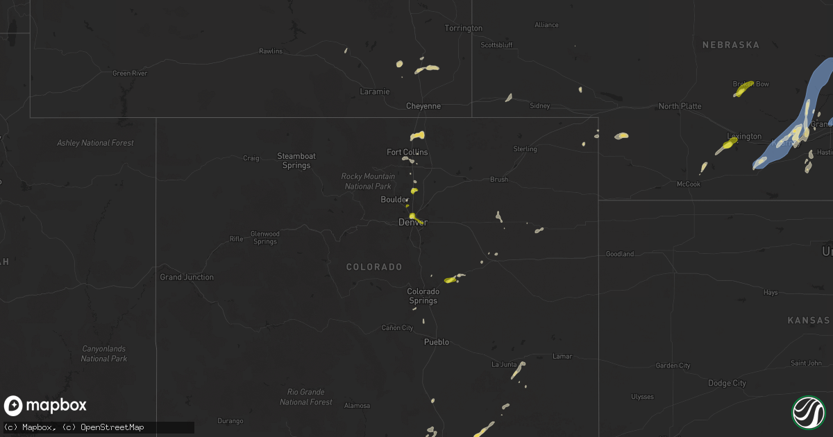
Hail Map on June 25, 2025
Get this storm
June 25 map
$229
one time, instant access
Download today. No call, no setup
Keep the $229
Bought the map and want the full workflow? Apply the entire $229 to a subscription within 7 days. None of it is wasted.
Every map, not just this one
This buys you this map. Subscription and you get every map we run, in the markets you choose from a few cities to whole states to nationwide. Plus real-time alerts the moment a storm fires.
Contact data
Name, contact info, occupancy, even credit band for addresses in the footprint. You go from where it hit to who to call.
Become the source they trust
Unlimited branding weather history reports on demand. You already have the documented answer ready for the property owner, and you are the one who showed up with it.
Property data and RoofTrace estimates
Pull up any address you have got, its value and the exact code rules for that jurisdiction, straight from One Click Code. Then RoofTrace estimates the squares, pitch, and roof value, priced the way you price.
States Impacted by Hail Map on June 25, 2025
Storm reports
Pennsylvania
| Date | Description |
|---|---|
| 06/25/20256:00 PM CDT | Tree down. Time estimated from radar. |
| 06/25/20255:38 PM CDT | Trees and wires down. Time estimated from radar. |
| 06/25/20255:35 PM CDT | Tree down. |
| 06/25/20255:25 PM CDT | Trees and wires down. Time estimated from radar. |
| 06/25/20255:20 PM CDT | Trees and wires down. Time estimated from radar. |
| 06/25/20255:15 PM CDT | Trees and wires down. Time estimated from radar. |
| 06/25/20255:05 PM CDT | A tree was reported down along quail hill road and knocked out power to some residents. |
| 06/25/20254:30 PM CDT | Tree down. |
| 06/25/20254:22 PM CDT | There were 2 trees reported down at this location. |
| 06/25/20254:10 PM CDT | A tree was reported down along state route 88 in the riverview area. |
| 06/25/20253:55 PM CDT | A tree was reported over the road on sr 88. |
| 06/25/20252:09 PM CDT | A tree was reported down on mockler road. |
| 06/25/20251:18 PM CDT | A couple of trees were reported down over powerlines with blown transformers. The damage occurred at the intersection of pine grove road and hillcrest drive. |
Texas
| Date | Description |
|---|---|
| 06/25/20255:01 PM CDT | Em relayed a report of two power poles snapped on cr 4105 to the northeast of ector. Time estimated by radar. |
Georgia
| Date | Description |
|---|---|
| 06/25/20256:00 PM CDT | Power lines reported down in cairo. |
| 06/25/20253:46 PM CDT | A local report indicates 1.00 inch wind near 1 SE Poplar Arbor Churc |
| 06/25/20253:22 PM CDT | Measured with rooftop anemometer. |
| 06/25/202511:15 AM CDT | Tree limbs on sr 18 both directions at balls church rd. All lanes closed. |
| 06/25/202511:10 AM CDT | Tree limbs on sr 26 both directions at lawton smith rd near adrian... Ga. All lanes closed. |
| 06/25/20251:35 AM CDT | 511ga reported tree limb on sr 520 eastbound at |
| 06/25/20251:35 AM CDT | 511ga reported tree limb |
| 06/25/202512:15 AM CDT | Tree l |
| 06/25/202512:15 AM CDT | The emergency manager relayed a report of a downed tree on old zebulon road near highway 109. |
| 06/25/202512:15 AM CDT | Tree limbs on sr 7 northbound at thomaston st. All lanes closed. |
| 06/25/202512:15 AM CDT | The emergency manager relayed a report of a downed tree on old zebulon road ne |
| 06/25/202512:15 AM CDT | The emergency manager relayed a rep |
| 06/25/202512:15 AM CDT | Tree limbs on sr 7 northbound at tho |
| 06/25/202512:15 AM CDT | Tree limbs on sr 7 northbound at thomaston s |
| 06/25/202512:09 AM CDT | The ham radio coordinator for upson |
| 06/25/202512:09 AM CDT | The ham radio co |
| 06/25/202512:09 AM CDT | The ham radio coordinator for upson county reports multiple trees blocking atwater rd between willingham springs rd and weems rd. |
| 06/24/202511:56 PM CDT | Tree downed across 300 block of anderson road. |
| 06/24/202511:56 PM CDT | The emergency manager relayed a report of a tree down in the 7600 block of highway 16/newnan road. |
| 06/24/202511:56 PM CDT | The emergency manager relayed a report of a tree down in the 7600 block of highway 16/newnan ro |
| 06/24/202511:45 PM CDT | Public reported a couple trees down at a location of elberta drive. |
| 06/24/202511:44 PM CDT | Tree downed across redwine road. |
| 06/24/202511:42 PM CDT | Tree downed across old greenville road south of goza road. |
| 06/24/202511:40 PM CDT | Trees downed near the intersection of hampton road and ga92. |
| 06/24/202511:35 PM CDT | Several trees and a power pole snapped near the intersection of hwy 74 and 54. |
| 06/24/202511:34 PM CDT | The emergency manager relayed a report of a downed tree in the 800 block of west wall street. |
| 06/24/202511:28 PM CDT | Public reported a tree down on a house on wilmington lane. |
| 06/24/202511:27 PM CDT | Tree downed across burroughs avenue. |
| 06/24/202511:27 PM CDT | The emergency manager relayed a report of a tree and powerlines down along the 1900 block of north hill street ext. |
| 06/24/202511:27 PM CDT | The emergency manager relayed a report of a |
| 06/24/202511:24 PM CDT | Public reported numerous trees down and fence damage along lost court in hampton. Radar indicates a downburst in the area likely produced 75-80 mph winds... Causing the |
| 06/24/202511:20 PM CDT | Large tree down on a house off thornwood court. |
| 06/24/202511:16 PM CDT | The emergency manager relayed a report of a tree down in the 4400 block of jackson road. |
| 06/24/202511:14 PM CDT | The emergency manager relayed a report of a downed tree in the 600 block of wallace road. |
| 06/24/202511:13 PM CDT | A tree was blown onto a shed on navaho road. |
| 06/24/202511:11 PM CDT | The emergency manager relayed a report of three trees down along the 1600 and 1700 blocks of locust grove road. |
| 06/24/202511:10 PM CDT | Public reported a powerline down along the 1100 block of millers mill road. |
| 06/24/202511:10 PM CDT | A 911 call center reported a tree down along carson sands rd. Time was estimated via radar data. |
| 06/24/202511:08 PM CDT | The emergency manager relayed a report of a tree down in the 300 block of east anderson road. |
| 06/24/202511:08 PM CDT | Tree down on wilton threatt road. Time estimated from radar. |
| 06/24/202511:08 PM CDT | Tree down on burkhalter drive. Time estimated by radar. |
| 06/24/202511:05 PM CDT | Tree limbs were on sr 90 both directions at dewey mcglamry rd blocking both lanes. |
| 06/24/202511:01 PM CDT | A 911 call center reported a tree down near the intersection of barrow bay and leah rd. Time was estimated via radar data. |
| 06/24/202511:01 PM CDT | Tree down on burkhalter drive. Time estimated by radar. |
| 06/24/202511:01 PM CDT | Tree down on wilton threatt road. Time estimated from radar. |
| 06/24/202511:01 PM CDT | Tree down on the intersection of se broad street and lillian street. Time estimated from radar. |
| 06/24/202510:58 PM CDT | A 911 call center reported a tree down along shady oak ln. Time was estimated via radar data. |
| 06/24/202510:58 PM CDT | A 911 call center reported a tree down near the intersection of barrow bay and leah rd. Time was estimated via radar data. |
| 06/24/202510:55 PM CDT | Tree down on the intersection of se broad street and lillian street. Time estimated from radar. |
| 06/24/202510:37 PM CDT | Tree down on brooklet- leefield rd at clito rd. Time estimated from radar. |
| 06/24/202510:36 PM CDT | Tree limbs on sr 19 both directions at durham mill rd. All lanes closed. |
| 06/24/202510:34 PM CDT | Tree down on cowboy way. Time estimated from radar. |
| 06/24/202510:29 PM CDT | Tree down on old river rd n and highway 301. Time estimated from radar. |
| 06/24/202510:05 PM CDT | Burke county em reported trees down blocking roadway at lake eleanor road and gough spur road. Time estimated by radar. |
| 06/24/20259:59 PM CDT | Multiple trees down on south maine. Time estimated from radar. |
| 06/24/20259:59 PM CDT | Multiple treees down on mims road. Time estimated from radar. |
| 06/24/20259:45 PM CDT | Burke county em reported trees down on powerlines along joyner oglesby road. Time estimated by radar. |
| 06/24/20259:23 PM CDT | Power lines down along ben arthur rd. |
| 06/24/20259:10 PM CDT | Report from emergency management of 3 trees down in northern banks county. |
| 06/24/20258:41 PM CDT | Quarter sized hail lasted a few seconds. |
| 06/24/20258:37 PM CDT | Trees blown down east of demorest. |
| 06/24/20258:35 PM CDT | Viewer report of pea to quarter size hail in lee county. |
| 06/24/20258:34 PM CDT | Social media report of hail up to quarter size in royston. |
| 06/24/20258:30 PM CDT | Tree blown down on a personal property along lumpkin road. |
| 06/24/20258:28 PM CDT | Tree down along the orchard road. |
| 06/24/20258:17 PM CDT | 911 dispatch reports numerous trees and powerlines down on hwy 197 between batesville and dicks hill pkwy. |
| 06/24/20258:07 PM CDT | Tree down and blocking the roadway at westmoreland rd near smith rd. |
| 06/24/20258:07 PM CDT | Reported at kaby asos. |
| 06/24/20258:05 PM CDT | Hail damaged the roof then water started to leak into the attic. |
| 06/24/20258:00 PM CDT | Trees downed along linda lane on the north side of carrollton. |
| 06/24/20257:45 PM CDT | Tree limbs on sr 200 eastbound at waller rd. Right lane blocked. |
| 06/24/20257:30 PM CDT | Corrects previous hail report from waco. Quarter-sized hail reported in waco. |
| 06/24/20257:30 PM CDT | Quarter-sized hail reported in waco. |
| 06/24/20257:17 PM CDT | Report of 1 inch hail near putney. |
| 06/24/20257:15 PM CDT | Several trees and power lines down in miller county. |
| 06/24/20257:00 PM CDT | Two trees down in baker county. |
Virginia
| Date | Description |
|---|---|
| 06/25/20256:42 PM CDT | Public reported a video of trees coming down along ebenezer road in campbell county virginia. |
| 06/25/20255:10 PM CDT | Multiple trees knocked down within the mineola neighborhood. Reports via social media. Time estimated from radar. |
| 06/25/20253:13 PM CDT | Vdot reports tree down onto rte 626 near midday lane. Time estimated from radar. |
| 06/25/20253:06 PM CDT | Tree down near intersection of gardner ln and warm springs pike |
| 06/25/20253:05 PM CDT | 911 center reports two trees down near the intersection of quarter branch rd and lovettsville rd. |
| 06/25/20253:04 PM CDT | Roof off of a house at 1352 free mason run rd |
| 06/25/20253:04 PM CDT | Roof off of a home near the intersection of stribling springs rd and free mason run rd. |
| 06/25/20252:59 PM CDT | 911 center reports a tree is blocking the southbound lanes of route 9 near harpers ferry rd. |
| 06/25/20252:55 PM CDT | Tree down onto powerlines near intersection of valley branch rd and scholars rd |
| 06/25/20252:50 PM CDT | Tree down near intersection of taylor spring ln and boyers rd |
| 06/25/20252:48 PM CDT | Tree down at 2394 ridgedale rd |
| 06/25/20252:46 PM CDT | Tree down onto powerlines at 1224 oakwood dr |
| 06/25/20252:37 PM CDT | Tree down near the intersection of warsaw ave and lee hwy. |
| 06/25/20252:37 PM CDT | Tree down near intersection of green st and n dogwood dr |
| 06/25/20252:35 PM CDT | Tree down onto powerlines at 1110 shenandoah st |
| 06/25/20252:23 PM CDT | A local report indicates 70 MPH wind near Dulles Intl Airport |
| 06/25/20252:14 PM CDT | Tree down near intersection of kratzer rd and rhones ln |
| 06/25/20252:00 PM CDT | Tree down onto powerlines at 3475 holsinger rd |
| 06/25/20251:47 PM CDT | Tree down at 19173 cold spring rd |
| 06/25/20251:43 PM CDT | Trees down along u.s. 220 near sinking spring. |
| 06/25/20251:36 PM CDT | Tree down near falling spring falls. |
| 06/25/20251:34 PM CDT | Tree down near intersection of cliff mills rd and brown more ln |
| 06/25/20251:17 PM CDT | Tree down near intersection of blantyre rd and old bust head rd |
| 06/25/20251:15 PM CDT | 3 inch diameter branch onto 12546 senedo rd |
| 06/25/20251:06 PM CDT | Several trees down between strasburg and toms brook va. |
| 06/25/202512:45 PM CDT | Five trees were down around the 3700 block of ashville road. |
| 06/25/202512:31 PM CDT | The 911 call center reported a tree down near us-1. Time estimated from radar. |
| 06/25/202512:17 PM CDT | Tree down near 920 wrights ln |
| 06/25/202512:03 PM CDT | Tree down onto powerlines at 1400 block of orange rd |
| 06/25/202510:43 AM CDT | Tree down on stage road. |
| 06/24/202511:01 PM CDT | Tree was reported down near the 100 block of stateline bridge road in pittsylvania county virginia. |
| 06/24/202510:58 PM CDT | Thunderstorm winds blew down a large section of fence. |
| 06/24/202510:30 PM CDT | Tree down at the intersection of motleys mill road and halifax road in pittsylvania county virginia. |
| 06/24/202510:12 PM CDT | Trees down near alton. |
| 06/24/202510:08 PM CDT | Tree down blocking road. |
| 06/24/202510:03 PM CDT | Tree downed by thunderstorm winds in the 100 block of stateline bridge road. |
| 06/24/20259:42 PM CDT | Tree down. |
| 06/24/20259:41 PM CDT | Tree down on eastover drive. |
| 06/24/20259:40 PM CDT | Tree on house causing significant damage to the house... Rooms now exposed to rainwater. |
| 06/24/20259:40 PM CDT | Tree down at intersection of broad street and norwood ave. |
| 06/24/20259:40 PM CDT | Power pole and wires down near police station. Lost commercial power. |
| 06/24/20259:35 PM CDT | Tree down near the intersection of hamilton blvd and williams st. |
| 06/24/20259:32 PM CDT | 2 trees down. |
| 06/24/20259:30 PM CDT | Tree down along clays mill rd. |
| 06/24/20258:42 PM CDT | Corrects previous tstm wnd dmg report from 2 nnw brookneal. Public reported a video of trees coming down along ebenezer road in campbell county virginia. |
| 06/24/20258:40 PM CDT | Tree down in the vicinity of swinging bridge rd. |
Illinois
| Date | Description |
|---|---|
| 06/25/20255:53 PM CDT | Estimated 80 mph tstorm wind gusts from suspected microburst. Several large trees down or uprooted. |
| 06/25/20255:09 PM CDT | Tree branches and trees down in town. |
| 06/25/20254:26 PM CDT | Damage to campers and a large branch down on a truck. |
| 06/25/20254:14 PM CDT | Large trees down. |
| 06/25/20254:13 PM CDT | Numerous trees damaged in ponderosa hills subdivision... Including several uprooted. Time estimated using radar. |
| 06/25/20254:09 PM CDT | Large tree branch down. |
| 06/24/20257:03 PM CDT | Photos shared on social media showing an unattached semi-trailer rolled onto its side and flattened corn crops on the east side of south beloit. Time estimated from rad |
| 06/24/20257:02 PM CDT | Trees downed... Multiple large tree branches snapped... And roof shingles peeled. Time estimated from radar. |
| 06/24/20257:02 PM CDT | 7 to 8 inch diameter tree uprooted. |
| 06/24/20257:01 PM CDT | Video shared by local broadcast media showing several trees snapped in south beloit off prairie hill road. Time estimated by radar. |
Montana
| Date | Description |
|---|---|
| 06/25/20256:34 PM CDT | A local report indicates 1.75 inch wind near 3 E Webster |
| 06/25/20256:24 PM CDT | A local report indicates 1.00 inch wind near 5 WNW Webster |
| 06/25/20253:45 PM CDT | Hail up to the size of quarters and wind gusts up to 30 mph. |
| 06/24/20257:00 PM CDT | Mesonet station ricmt rice ridge. |
Wyoming
| Date | Description |
|---|---|
| 06/25/20256:23 PM CDT | A local report indicates 1.00 inch wind near 14 SW Sundance |
| 06/25/20255:06 PM CDT | A local report indicates 1.00 inch wind near 9 SSE Dwtn Gillette |
| 06/25/20254:25 PM CDT | Dime to quarter hail. |
Minnesota
| Date | Description |
|---|---|
| 06/25/20256:13 PM CDT | Video relayed via social media of a tornado on the ground south of lake city. |
| 06/25/20256:13 PM CDT | Video relayed via social media of a to |
| 06/25/20256:05 PM CDT | 911 center reported tornado on the ground south of hokah. |
| 06/25/20255:52 PM CDT | Spotter reported tornado on the ground looking north from cr 17 and hwy 65. |
| 06/25/20255:52 PM CDT | Utility pole down on main street near the post office. Crews on scene. |
| 06/25/20255:22 PM CDT | Tds on radar. |
| 06/25/20254:44 PM CDT | Law enforcement reports a tornado southwest of ellendale... Moving northeast. |
| 06/25/20254:37 PM CDT | Law enforcement reports a tornado at the intersection of 310 st. And 685th ave. Outside hartland. |
| 06/25/20254:33 PM CDT | Damage to barn/shed at farm residence. |
| 06/25/20254:26 PM CDT | Law enforcement reports a tornado just west of freeborn. |
| 06/25/20254:26 PM CDT | Relayed by county em. Tornado gaining strength. |
| 06/25/20254:00 PM CDT | A local report indicates 58 MPH wind near 1 E Ostrander |
| 06/25/20254:00 PM CDT | Law enforcement reports tornado over freeborn lake. |
| 06/25/20253:42 PM CDT | Multiple reports of a tornado sw of alden. |
South Dakota
| Date | Description |
|---|---|
| 06/25/20256:57 PM CDT | A local report indicates 62 MPH wind near 12 WSW Castle Rock |
| 06/25/20256:35 PM CDT | Two semis were overturned on i-90 at mile markers 114 & 119. |
| 06/25/20255:40 PM CDT | A local report indicates 1.25 inch wind near 3 WSW Sheridan Lake |
| 06/24/20258:30 PM CDT | A local report indicates 61 MPH wind near 1 N Buffalo |
| 06/24/20257:32 PM CDT | A local report indicates 1.50 inch wind near 3 W Ladner |
Florida
| Date | Description |
|---|---|
| 06/25/20256:30 PM CDT | Trees reported down on powerlines and across roadways in and around esto. |
| 06/25/20256:30 PM CDT | Trees reported down on powerlines and across roadways in and around pittman. |
| 06/25/20256:27 PM CDT | Broadcast media relayed report of quarter size hail estimated near auburn... Fl. Time estimated by radar. |
| 06/25/20256:15 PM CDT | Trees and powerlines reported down across jackson county. |
| 06/25/20256:15 PM CDT | Trees reported down on powerlines and across roadways in and around ponce de leon. |
| 06/25/20256:07 PM CDT | Multiple reports with video and pictures of debris and tornado damage near ulmerton rd. In largo... Fl. |
| 06/25/20256:00 PM CDT | Trees and powerlines reported down in and around caryville. |
| 06/25/20256:00 PM CDT | Public reported quarter size hail in north ft. Myers. Time was estimated based on radar data. |
| 06/25/20255:54 PM CDT | Trees and powerlines reported down in and around chipley. |
| 06/25/20255:52 PM CDT | Quarted sized hail reported at 33rd ave north st petersburg. |
| 06/25/20255:35 PM CDT | Trees and powerlines reported down across jackson county. |
| 06/25/20255:23 PM CDT | Power line down along parkwood road. |
| 06/25/20255:23 PM CDT | At least 1.25 inch hail on i-10 at exit 136. |
| 06/25/20255:12 PM CDT | Tree down on anderson road. |
| 06/25/20255:06 PM CDT | Tree down near 8747 se cr69. |
| 06/25/20254:59 PM CDT | Emergency management reports estimate of quarter size hail in the airport road area of milton. |
| 06/25/20254:59 PM CDT | Trees and powerlines reported down across gadsden county. |
| 06/25/20254:54 PM CDT | Report from mping: quarter |
| 06/25/20254:15 PM CDT | Public report via social media from near santa rosa beach. |
| 06/25/20253:58 PM CDT | Levy ave and engineering way. |
| 06/25/20253:55 PM CDT | 1 inch hail observed in downtown tallahassee. |
| 06/25/20253:55 PM CDT | Tree reported down on structure near duncan drive. |
| 06/25/20253:55 PM CDT | Trees and powerlines reported down across wakulla county. |
| 06/25/20253:55 PM CDT | Tree reported down on ox bow and ox bottom rd. |
| 06/25/20253:55 PM CDT | Tree reported down on iamonia landing and cr12. |
| 06/25/20253:55 PM CDT | Hail of 1.5 inches was reported in indian head acres. |
| 06/25/20253:50 PM CDT | Trees reported down near deer lake w and waters meet drive. |
| 06/25/20253:45 PM CDT | Tree reported down on natural bridge rd... E of country oaks. |
| 06/25/20253:30 PM CDT | Ktdr gusted to 61 mph. |
| 06/25/20253:15 PM CDT | Tree reported down on the north side of gulf county. |
Wisconsin
| Date | Description |
|---|---|
| 06/25/20256:54 PM CDT | Tds noted on radar. |
| 06/25/20256:50 PM CDT | Tds on radar with visual confirmation from office before becoming clouded in rain. |
| 06/24/20258:27 PM CDT | Multiple trees uprooted. Photos received via email... Time estimated from radar. |
| 06/24/20258:04 PM CDT | Relayed by law enforcement. Time estimated from radar. |
| 06/24/20257:58 PM CDT | Time estimated from radar. |
| 06/24/20257:58 PM CDT | Relayed by law enforcement. Time estimated from radar. |
| 06/24/20257:58 PM CDT | Report relayed by law enforcement. Time estimated from radar. |
| 06/24/20257:52 PM CDT | Report relayed by law enforcement. Time estimated from radar. |
| 06/24/20257:44 PM CDT | Multiple trees down... A couple uprooted. Photos received via social media. Time estimated from radar. |
| 06/24/20257:22 PM CDT | Dispatch center reports multiple trees and power lines down in la prairie township. Time estimated from radar. |
| 06/24/20257:20 PM CDT | Multiple trees downed. |
Alabama
| Date | Description |
|---|---|
| 06/25/20256:30 PM CDT | Power lines down near county road 16 and kelly rd. |
| 06/25/20256:22 PM CDT | Brookley field asos reports thunderstorm wind gust of 58mph. |
| 06/25/20256:22 PM CDT | Corrects previous tstm wnd gst report from 1 sse brookley field. Brookley field asos reports thunderstorm wind gust of 58mph. |
| 06/25/20256:18 PM CDT | Numerous trees and power lines down near the community of black... Including near old esto rd and w v armstrong rd. |
| 06/25/20255:10 PM CDT | A parked truck trailer was overturned at 43340 u.s. Highway 72 in stevenson. |
| 06/25/20255:10 PM CDT | A power pole was knocked down on 2nd street near old mt carmel. |
| 06/25/20254:50 PM CDT | A large tree was down in the road at cr 711 at highway 117. |
| 06/25/20254:45 PM CDT | Quarter sized hail reported in rosalie. |
| 06/25/20254:36 PM CDT | A tree was knocked down at 4105 al highway 117 blocking both lanes. Time estimated by radar. |
| 06/25/20254:35 PM CDT | Golf ball sized hail was reported in pisgah. |
| 06/25/20254:03 PM CDT | Multiple |
| 06/25/20254:03 PM CDT | Multiple trees down on cr 409... 120... 100 and 430. A tree was knocked down on a home on cr 430. |
| 06/25/20253:52 PM CDT | A tree was knocked down at cr 120 at highway 35. |
| 06/25/20253:50 PM CDT | A tree was knocked down in section area. |
| 06/25/20253:35 PM CDT | Corrects previous tstm wnd dmg report from 3 ese section. A tree was knocked down at cr 120 at highway 35. Time estimated by radar. |
| 06/25/20253:32 PM CDT | A large tree was down on cr 100 blocking the road. Time estimated by radar. |
| 06/25/20253:32 PM CDT | A tree was uprooted and landed on a carport at 383 cr 275. Time estimated by radar. |
| 06/25/20253:32 PM CDT | Corrects previous tstm wnd dmg report from 2 w powell. Multiple trees down on cr 409... 120... 100 and 430. A tree was knocked down on a home on cr 430. Time estimated |
| 06/25/20253:32 PM CDT | A few trees were knocked down in the powell area near the county line. Time estimated by radar. |
| 06/25/20253:32 PM CDT | A tree was split and knocked down partially onto a home at 135 cr 430. Roof was damaged. Time estimated by radar. |
| 06/25/20251:45 AM CDT | Numerous trees down from a microburst on ruby lane including one tree on a house. |
| 06/24/20259:05 PM CDT | Numerous trees and power lines down throughout coffee county. |
| 06/24/20258:42 PM CDT | Power lines down on dale county road #43. |
| 06/24/20258:36 PM CDT | Tree down on county road 59. |
| 06/24/20258:34 PM CDT | Report of tree on a vehicle on county road 14. |
| 06/24/20257:49 PM CDT | Tree down along highway 52. |
| 06/24/20257:19 PM CDT | Trees down near the intersection of county road 415 and 420 in coffee county... Relayed by nws mobile via covington county em. |
| 06/24/20257:11 PM CDT | Ham radio operator relays report of power outages scattered throughout covington county along with several tree limbs taken down and powerlines taken down. Trees report |
| 06/24/20257:03 PM CDT | Tree reported down in enterprise. |
| 06/24/20257:03 PM CDT | Multiple trees reported down in southern coffee county. |
Ohio
| Date | Description |
|---|---|
| 06/25/20255:02 PM CDT | Multiple trees reported down with lines... Along with a snapped telephone pole. Time is estimated by radar. |
| 06/25/20254:58 PM CDT | A couple of trees were reported down at the intersection of sr26 and connor ridge rd. |
| 06/25/20254:57 PM CDT | Trees reported down... Some of which were uprooted... With a very localized path of damage and measured wind gust of 52 mph. Time is estimated by radar. |
| 06/25/20254:40 PM CDT | Estimated 60 mph winds. |
| 06/25/20254:38 PM CDT | A local report indicates 70 MPH wind near 5 NW North Fairfield |
| 06/25/20254:05 PM CDT | Several trees down across thompson township. Time estimated via radar. |
| 06/25/20253:49 PM CDT | Several large tree branches down near lafayette avenue in urbana. |
| 06/25/20253:00 PM CDT | A tree and a number of branches were reported to be blown down. |
| 06/25/20252:52 PM CDT | Numerous large trees down on the south side of sidney... Including on franklin avenue and ohio avenue. |
| 06/25/20252:51 PM CDT | One tree downed on a power line on south ohio street. |
| 06/25/20252:20 PM CDT | Several reports of downed trees in powerlines in the eastern and northeastern portions of knox county. |
| 06/25/20251:42 PM CDT | Delayed report. 2 large trees down along with multiple large branches. Trampoline caused damage to one vehicle. Time estimated by radar. |
| 06/25/20251:21 PM CDT | A tree was reported down on edie hill road se just northwest of stillwater. |
| 06/25/202512:54 PM CDT | Two trees downed at the intersection of ostrander road and route 257. |
| 06/25/202512:48 PM CDT | Multiple reports of wires and trees down between etna and kirkersville along us 40. Time estimated from radar. |
Iowa
| Date | Description |
|---|---|
| 06/25/20255:45 PM CDT | Peak gust reported by clarion awos. |
| 06/25/20255:28 PM CDT | Healthy tree branch down... E 10 inches in diameter. |
| 06/25/20255:10 PM CDT | Corrects previous tstm wnd dmg report from 2 w fulton. Healthy tree branch down... E 10 inches in diameter. |
| 06/25/20255:10 PM CDT | Healthy tree branch down... E 10 inches in diameter. |
| 06/25/20255:08 PM CDT | Multiple trees down in the city of clinton blocking roads. |
| 06/25/20254:42 PM CDT | Pws measured a 60 mph gust. Wires also reported down in grand mound. |
| 06/25/20254:41 PM CDT | Large trees down in town. |
| 06/25/20254:31 PM CDT | Pictures of a roof panel off a farm structure and the total destruction of detached garage. Estimated 70-80 mph winds. |
| 06/25/20254:29 PM CDT | Pws measured gust with damage nearby suggesting 70 - 80 mph downburst. |
| 06/25/20254:05 PM CDT | Large tree limb down on the road. |
| 06/24/20257:18 PM CDT | Tds on radar and report of tornado on the ground from dispatch. |
Kansas
| Date | Description |
|---|---|
| 06/25/20255:02 PM CDT | Up846 reported the gust. |
Maryland
| Date | Description |
|---|---|
| 06/25/20254:54 PM CDT | Trees down near intersection of broomes island rd and williams wharf rd |
| 06/25/20254:45 PM CDT | Multiple trees down near intersection of sixes rd and joe harris rd |
| 06/25/20254:37 PM CDT | Tree down onto powerlines near intersection of md 648 and brandywine ave |
| 06/25/20254:32 PM CDT | Trees onto powerlines near intersection of adelina rd and sixes rd |
| 06/25/20254:30 PM CDT | Multiple trees down and a few trees down onto powerlines along rt. 231 between jibsail dr and adelina rd |
| 06/25/20254:30 PM CDT | Dozens of trees snapped and uprooted scattered across the area along route 231 from the patuxent bridge to adelina rd... Including in hallowing point park. County repor |
| 06/25/20254:25 PM CDT | Tree down at 5150 buena vista rd |
| 06/25/20253:57 PM CDT | 60mph thunderstorm wind gust measured at andrews afb. |
| 06/25/20253:55 PM CDT | Mdot reports tree fell onto the inner loop at mm14 blocking three right lanes. Time estimated from radar. |
| 06/25/20253:45 PM CDT | A wind gust of 62 mph was reported at andrews air force base. |
| 06/25/20253:31 PM CDT | Multiple reports of multiple trees and multiple powerlines down in capitol heights area |
| 06/25/20253:22 PM CDT | Tree down onto powerlines at cheverly ave and landover rd |
| 06/25/20252:47 PM CDT | Mdot reports tree down onto md-2 at college parkway... Blocking southbound lanes. |
| 06/25/20252:45 PM CDT | Mdot reports tree down on md-648 baltimore annapolis blvd... Blocking the road. |
| 06/25/20252:36 PM CDT | A couple trees were down in the severna park area... Including a tree that fell onto a house. |
| 06/25/20252:35 PM CDT | Mdot reports tree down onto road at intersection of md-100 and md-177. |
| 06/25/20252:18 PM CDT | Numerous trees down near the intersection of trap run rd and blooming rose rd. |
| 06/25/20252:18 PM CDT | Numerous trees uprooted and snapped along blooming rose rd between trap run rd and white rock rd... As well as along trap run rd. Between blooming rose rd. And white ro |
| 06/25/202512:47 PM CDT | Half dozen trees down near and around cockeysville md. |
Nebraska
| Date | Description |
|---|---|
| 06/25/20253:55 PM CDT | A local report indicates 70 MPH wind near 7 WSW Cairo |
| 06/25/20253:35 PM CDT | A local report indicates 58 MPH wind near 3 N Kearney |
| 06/25/20253:35 PM CDT | A local report indicates 72 MPH wind near 4 ESE Riverdale |
| 06/25/20253:30 PM CDT | Tree damage. |
| 06/25/20253:28 PM CDT | 6 inch tree branch down. |
| 06/25/20253:26 PM CDT | A local report indicates 68 MPH wind near 3 WNW Loomis |
| 06/25/20253:23 PM CDT | Asos station kgri grand island airport. |
Indiana
| Date | Description |
|---|---|
| 06/25/20253:33 PM CDT | Tree and powerlines down. |
| 06/25/20251:46 PM CDT | Tree downed near s. State road 101. Time estimated by radar. |
| 06/25/20251:29 PM CDT | Tree downed in laurel. Time estimated by radar. |
| 06/25/20251:19 PM CDT | About 4 to 6 trees downed throughout the county... With several near/in the connersville area. Time estimated by radar. |
Colorado
| Date | Description |
|---|---|
| 06/25/20252:30 PM CDT | A local report indicates 1.00 inch wind near 5 WSW Calhan |
| 06/24/20259:13 PM CDT | A local report indicates 1.00 inch wind near 1 W Firestone |
| 06/24/20259:09 PM CDT | Report from mping: quarter |
| 06/24/20259:09 PM CDT | Report from mping: quarter . |
North Carolina
| Date | Description |
|---|---|
| 06/25/20256:36 PM CDT | Social media picture of a tree down across powerlines in the paw creek area. |
| 06/25/20256:00 PM CDT | Trees down near intersection of nc 22 and nc 27. |
| 06/25/20255:45 PM CDT | Scattered outages due to fallen trees and/or utility lines from matthews to indian trail. Time estimated from radar. |
| 06/25/20255:29 PM CDT | Keqy asos. |
| 06/25/20255:25 PM CDT | A number of trees downed in the nc 216 area. |
| 06/25/20255:25 PM CDT | Trees down across western hoke co along nc211 north of plank rd. |
| 06/25/20255:25 PM CDT | Social media video of a tree down across a fence. |
| 06/25/20255:24 PM CDT | Trees down on dallas cherryville hwy & puetts chapel rd. Time estimated from radar. |
| 06/25/20255:20 PM CDT | Trees down near hwy 274 and dameron rd. |
| 06/25/20255:20 PM CDT | Trees uprooted and/or snapped in vicinity of county line rd intersection with beattie rd. Minor roof damage to a barn. Time estimated. |
| 06/25/20255:20 PM CDT | Tree down on house on cenco dr. Time estimated from radar. |
| 06/25/20255:17 PM CDT | Downed trees reported near the intersection of swamp fox highway east and indigo flats east. Time estimated by radar. |
| 06/25/20255:15 PM CDT | Relayed through facebook. |
| 06/25/20255:06 PM CDT | Downed trees reported near the intersection of pine level church road and ramsey ford road. Time estimated by radar. |
| 06/25/20255:02 PM CDT | Tree down on utility equipment. |
| 06/25/20255:00 PM CDT | Large trees and utility lines downed along laurel park rd. |
| 06/25/20254:59 PM CDT | Report from mping: quarter |
| 06/25/20254:52 PM CDT | Tree down on utility equipment. |
| 06/25/20254:46 PM CDT | Tree down on utility equipment. |
| 06/25/20254:45 PM CDT | Social media picture of trees down in the tryon area. |
| 06/25/20254:41 PM CDT | Social media picture of several trees down in the columbus area. |
| 06/25/20254:37 PM CDT | Utility lines downed along providence rd. |
| 06/25/20254:36 PM CDT | Tree down on utility equipment. |
| 06/25/20254:32 PM CDT | Report from mping: quarter |
| 06/25/20254:30 PM CDT | Tree down on road near columbus regional |
| 06/25/20254:30 PM CDT | Trees down in the etowah area. |
| 06/25/20254:25 PM CDT | Social media picture of dime to quarter size hail along duncan hill rd in hendersonville. |
| 06/25/20254:20 PM CDT | Trees and/or utility lines down causing outages. |
| 06/25/20254:16 PM CDT | Report from mping: quarter |
| 06/25/20254:15 PM CDT | Social media report of hail up to quarter size in the mountain home area. |
| 06/25/20254:14 PM CDT | Tree limbs and debris had to be removed from the road near bayfield rd. And gibson rd. |
| 06/25/20254:13 PM CDT | Tree across andrew jackson hwy... Near ida mill rd. |
| 06/25/20254:12 PM CDT | Trees and debris across west blvd... Between turnpike rd. And us 401 and also in the area of park cir. And peden st. |
| 06/25/20254:09 PM CDT | Several trees down around the forest city and bostic areas. |
| 06/25/20254:05 PM CDT | Trees down along dunn rd between spiveys corner and salemburg. |
| 06/25/20254:00 PM CDT | Trees and/or utility lines down causing outages. |
| 06/25/20253:58 PM CDT | Social media report of nickel to quarter size hail in the edneyville area. |
| 06/25/20253:55 PM CDT | Quarter size hail reported along burney road. |
| 06/25/20253:45 PM CDT | Trees down across northern sampson co. |
| 06/25/20253:45 PM CDT | Quarter size hail reported along burney road. |
| 06/25/20253:45 PM CDT | Multiple trees down in the area of mccoll rd.... Hasty rd.... Oakwood dr.... And sycamore ln. |
| 06/25/20253:45 PM CDT | Roughly 20 trees down in elizabethtown. Time estimated via radar. |
| 06/25/20253:34 PM CDT | Duplin county 911 center relays report of powerlines down on church street. Time estimated by radar. |
| 06/25/20253:34 PM CDT | Tree down across johns rd.... Between pond dr. And pea bridge rd. |
| 06/25/20253:33 PM CDT | Downed trees blocking hwy 70. |
| 06/25/20253:30 PM CDT | Tree and/or utility line damage leading to outages. |
| 06/25/20253:30 PM CDT | Numerous trees down in the county... Including some on johns rd/us 501. |
| 06/25/20253:25 PM CDT | Trees downed near fortune rd and us 64. |
| 06/25/20253:24 PM CDT | Tree down blocking both lanes of n. King st.... Between w. Bizzel st. And hillside ave. |
| 06/25/20253:16 PM CDT | Duke energy reported power outage caused by fallen trees damaging equipment. |
| 06/25/20253:14 PM CDT | Duke energy reported power outage caused by fallen trees damaging equipment. |
| 06/25/20253:10 PM CDT | Tree downed on a vehicle. |
| 06/25/20253:07 PM CDT | Social media report of hail up to quarter size just east of marion. |
| 06/25/20253:02 PM CDT | Trees down on nc 581 near strickland rd. |
| 06/25/20253:00 PM CDT | Trees down on utility equipment. |
| 06/25/20253:00 PM CDT | Persistent quarter size hail reported near wayne-sanderson farms in st. Pauls. |
| 06/25/20253:00 PM CDT | Trees down near hankins and yancey rds. |
| 06/25/20252:56 PM CDT | Trees down on nc 97. |
| 06/25/20252:50 PM CDT | Trees down on us-64 near nash/franklin county line. |
| 06/25/20252:50 PM CDT | Trees down on power equipment. |
| 06/25/20252:50 PM CDT | A local report indicates 1.00 inch wind near 4 ENE Pilot |
| 06/25/20252:43 PM CDT | Downed trees and power outages. |
| 06/25/20252:40 PM CDT | Tree and/or utility line damage near patricia rd. |
| 06/25/20252:38 PM CDT | Outages from storm damage near paint fork rd. |
| 06/25/20252:36 PM CDT | Corrects previous tstm wnd dmg report from 4 ese youngsville. Numerous trees down east of youngsville. |
| 06/25/20252:36 PM CDT | Multiple large pine trees down at 1300 tarboro rd. |
| 06/25/20252:30 PM CDT | A local report indicates 1.00 inch wind near Little Switzerland |
| 06/25/20252:30 PM CDT | Numerous trees down across northeastern nash co. |
| 06/25/20252:30 PM CDT | Trees down southwest of clinton. |
| 06/25/20252:24 PM CDT | Duke energy outage for 160 customers caused by damaged equipment from fallen trees or limbs. |
| 06/25/20252:22 PM CDT | Tree down on power lines on 2nd st. |
| 06/25/20252:20 PM CDT | Multiple trees down in goldsboro... Including at least one at 707 mulberry st. |
| 06/25/20252:20 PM CDT | Tree and utility line damage leading to outages. Time approximate. |
| 06/25/20252:10 PM CDT | One tree down. |
| 06/25/20251:56 PM CDT | Trees down and resulting power outages. |
| 06/25/20251:46 PM CDT | Trees down between essex and hollister per duke energy outage map. |
| 06/25/20251:40 PM CDT | Corrects previous tstm wnd dmg report from 5 n bat cave. Tree and/or utility line damage near patricia rd. |
| 06/25/20251:36 PM CDT | Numerous trees down east of youngsville. |
| 06/25/20251:32 PM CDT | Trees down near i-85 exit 214. |
| 06/25/20251:30 PM CDT | Trees down along nc 43. |
| 06/25/20251:10 PM CDT | Trees down near 158 bypass and frazier rd. |
| 06/25/20251:00 PM CDT | Trees reported down via social media reports near old ferrell road. |
| 06/24/202511:43 PM CDT | Tree down at the intersection of manual and hall roads near mayodan in rockingham county nc. |
| 06/24/202511:41 PM CDT | Corrects previous tstm wnd dmg report from 3 s lawsonville. Tree down near intersection of green meadow loop road and grooms road. |
| 06/24/202511:41 PM CDT | Tree down near intersection oi green meadow loop road and grooms road. |
| 06/24/202511:23 PM CDT | Tree down on power lines. |
| 06/24/202511:23 PM CDT | Tree down near intersection of case school road and nc-704. |
| 06/24/202511:19 PM CDT | Trees down in the yanceyville area. |
| 06/24/202511:00 PM CDT | Trees downed and shed roof blown off. |
| 06/24/202510:56 PM CDT | Trees down in blanch. |
| 06/24/202510:43 PM CDT | Tree down on power line along glovenia street. |
| 06/24/202510:37 PM CDT | Roof blown off mobile home. Four uninjured occupants displaced. Additionally... Tree and power pole downed on property. |
| 06/24/202510:34 PM CDT | Tree down near intersection of garrett road and nc-87. |
West Virginia
| Date | Description |
|---|---|
| 06/25/20256:57 PM CDT | Tree down on smithtown road. |
| 06/25/20256:50 PM CDT | A tree was reported down at the intersection of orr st. And blaine st. |
| 06/25/20256:05 PM CDT | Power outage affecting 138 customers reported along browns creek rd south of us route 60. |
| 06/25/20255:55 PM CDT | Power outage due to tree damage reported south of teays valley rd. |
| 06/25/20255:44 PM CDT | Tree down on state route 20. |
| 06/25/20254:00 PM CDT | Tree down. |
| 06/25/20254:00 PM CDT | Tree down. |
| 06/25/20254:00 PM CDT | Tree down. |
| 06/25/20253:44 PM CDT | Tree reported down blocking 4h camp rd. |
| 06/25/20253:26 PM CDT | A few trees reported down. |
| 06/25/20253:20 PM CDT | Tree down on us-33. |
| 06/25/20253:20 PM CDT | Tree down on power lines near the intersection of bedington rd. And miss staci dr. |
| 06/25/20253:20 PM CDT | Tree down covering the road on route 92. |
| 06/25/20251:58 PM CDT | A tree was down along apple harvest drive. |
| 06/25/20251:32 PM CDT | A tree was down along williamsport pike and foster drive. |
| 06/25/20251:30 PM CDT | A tree was down on the 1200 block of st. Andrews drive. |
| 06/25/202512:30 PM CDT | Tree down onto powerlines near intersection of winchester ave and us 220 |
| 06/25/202512:13 PM CDT | Tree down onto powerlines at 3000 capon river rd |
| 06/25/202512:07 PM CDT | Tree down onto powerlines at 4000 block of hickory corner rd |
| 06/25/202511:54 AM CDT | Tree down onto powerlines near 9000 block of south branch river rd |
| 06/25/202511:32 AM CDT | Tree down on northwestern pk. Just west of junction... Wv. |
| 06/25/202511:28 AM CDT | Tree down onto powerlines near 200 trinity rd |
New Mexico
| Date | Description |
|---|---|
| 06/25/20253:15 PM CDT | Two different reports received of quarter size hail on the north side of los alamos. |
South Carolina
| Date | Description |
|---|---|
| 06/25/20256:53 PM CDT | Scdps reported tree down on bel ivy rd near the intersection with floyd rd. Time estimated by radar. |
| 06/25/20256:48 PM CDT | Scdps website reported a tree down on i-95 over the black river swamp. Time estimated by radar. |
| 06/25/20256:48 PM CDT | Sc dps reports tree down over cecil mcfadden rd near gable. |
| 06/25/20256:46 PM CDT | Scdps website reported a tree down on i-95 near exit 132. Time estimated by radar. |
| 06/25/20256:45 PM CDT | Social media picture of a tree down in the mountville area. |
| 06/25/20256:45 PM CDT | Tree down on roadway at us-17a and sc-41. A car crashed into the tree a short time later - no injuries. |
| 06/25/20256:43 PM CDT | Trees down and a medal roof blown off barn. 176 adger road. Possible tornado. |
| 06/25/20256:43 PM CDT | Scdps website reported a tree in roadway near the intersection of bethel church road and sanford drive. Time estimated by radar. |
| 06/25/20256:42 PM CDT | Scdps website reported a tree down on us-321 near the intersection of airport road. Time estimated by radar. |
| 06/25/20256:36 PM CDT | Social media picture of trees down south of laurens. |
| 06/25/20256:36 PM CDT | Tree down on utility equipment. |
| 06/25/20256:31 PM CDT | Tree down along ab jackson rd. |
| 06/25/20256:30 PM CDT | Fairfield county |
| 06/25/20256:30 PM CDT | Fairfield county dispatch reports tree down on dave jenkins rd near blair. Time estimated by radar. |
| 06/25/20256:20 PM CDT | Outages near old richburg rd due to fallen trees and/or utility lines. |
| 06/25/20256:20 PM CDT | Large tree down on roadway. Kings river road at knight circle in pawleys island. |
| 06/25/20256:20 PM CDT | *** 1 inj *** large tree down on roadway. Kings river road at knight circle in pawleys island. Tree struck a pedestrian who was running on the bike path... Who was then |
| 06/25/20256:20 PM CDT | Lancaster county dispatch reported trees down on gold mine hwy at estridge ave. Time estimated by radar. |
| 06/25/20256:15 PM CDT | Tree down on sc-51 near hemingway lane. Time estimated via radar. A car crashed into the tree a short time later - no injuries. |
| 06/25/20256:15 PM CDT | Tree down in roadway. Rose hill and antwine drive in georgetown. |
| 06/25/20256:10 PM CDT | Tree down on a powerline in pelzer. |
| 06/25/20256:00 PM CDT | Large down in the roadway... 3600 block of old pee dee road in hemingway. Time estimated via radar |
| 06/25/20256:00 PM CDT | Quarter-sized hail near intersection of cheyenne dr. And capewood rd. Time estimated from radar. |
| 06/25/20256:00 PM CDT | Approx 3000 outages around spartanburg due to tree and utility line damage. Event time is based on radar. |
| 06/25/20255:56 PM CDT | Trees and powerlines down around the fountain inn area. |
| 06/25/20255:55 PM CDT | Trees downed along regent pkwy. |
| 06/25/20255:55 PM CDT | Lancaster county dispatch reported trees down on camp creek rd at mockingbird rd. Time estimated by radar. |
| 06/25/20255:51 PM CDT | Sc highway patrol reports tree down on forest lake dr between s stanley dr and s knollwood rd |
| 06/25/20255:50 PM CDT | Spotter reports trees down and power outages in florence... Sc |
| 06/25/20255:50 PM CDT | Numerous large limbs downed in the travelers rest area. |
| 06/25/20255:48 PM CDT | Trees and powerlines down in the powdersville area. |
| 06/25/20255:42 PM CDT | Trees down on roof of home near ridge rd at glenn rd. Time based on radar. |
| 06/25/20255:41 PM CDT | Golf ball hail at ridge rd and glenn rd. Time estimated from radar. |
| 06/25/20255:40 PM CDT | Tree down on elm st in conway... Near 16th ave. Time estimated via radar. |
| 06/25/20255:38 PM CDT | Social media picture of trees down in simpsonville. |
| 06/25/20255:36 PM CDT | Social media picture of a tree down in mauldin. |
| 06/25/20255:36 PM CDT | Up to quarter size hail fell along hudson st in taylors. |
| 06/25/20255:36 PM CDT | Numerous large limbs and several trees downed in the vicinity of downtown greenville. |
| 06/25/20255:29 PM CDT | Tree down on chestnut st in darlington |
| 06/25/20255:25 PM CDT | Tree down on road at hartsville hwy and bethlehem rd. Time estimated via radar. |
| 06/25/20255:25 PM CDT | Several trees and powerlines down on the west side of spartanburg. |
| 06/25/20255:24 PM CDT | Sc highway patrol reports tree down on us-701 and sc-22 |
| 06/25/20255:20 PM CDT | Tree down across aviation parkway. |
| 06/25/20255:15 PM CDT | Sc highway patrol reports tree down on macedonia dr between heritage rd and red bluff rd. Time estimated via radar. |
| 06/25/20255:15 PM CDT | Approx 2000 outages due to fallen trees and utility lines from tigerville south to greenville. Time ranged from 600 to 630 pm. |
| 06/25/20255:13 PM CDT | Several trees down around the tigerville area... Some on powerlines. |
| 06/25/20255:10 PM CDT | A smattering of downed trees and powerlines between east gaffney and cherokee falls. |
| 06/25/20255:10 PM CDT | Lancaster dispatch reported trees down at barberville rd at harrisburg rd. Time estimated by radar. |
| 06/25/20255:08 PM CDT | Trees down near john dodd and new cut roads. |
| 06/25/20255:05 PM CDT | Report of tree down on mechanicsville hgwy near greenfield rd |
| 06/25/20255:00 PM CDT | Sc highway patrol reports tree down on green sea rd near church rd. Time estimated via radar. |
| 06/25/20254:52 PM CDT | Social media report of dime to quarter size hail in the boiling springs area. |
| 06/25/20254:50 PM CDT | Tree down. Time estimated from radar. |
| 06/25/20254:48 PM CDT | Two trees down in separate locations in landrum. Time estimated from radar. |
| 06/25/20254:39 PM CDT | Tree down on sc-9 near covington rd |
| 06/25/20254:25 PM CDT | Tree down in hamer... Sc |
| 06/24/20259:56 PM CDT | Emergency manager reported a tree down on the block of 1500 wichman street. It's blocking both lanes. |
| 06/24/20259:53 PM CDT | Emergency manager reported a tree down on the block of 15800 hendersonville highway. It's blocking both lanes. |
| 06/24/20259:51 PM CDT | Emergency manager reported a tree down on public landing lane. |
| 06/24/20259:39 PM CDT | Emergency manager reported at tree down on the 11500 block of hendersonville highway. It is blocking both lanes. |
| 06/24/20259:27 PM CDT | Tree down along 500 block of roadside dr. Time was estimated via radar data. |
| 06/24/20259:27 PM CDT | Tree down on residence at pentgage ct. Time estimated from radar. |
| 06/24/20259:24 PM CDT | Tree down on residence along the 100 block of fannie lane. Time was estimated via radar data. |
| 06/24/20259:20 PM CDT | Emergency manager reported golf ball sized hail |
| 06/24/20259:15 PM CDT | Tree down on black creek rd. Time estimated from radar. |
| 06/24/20259:14 PM CDT | Emergency manager reported a tree down on the 2000 block of mewville road. It's blocking both lanes. |
| 06/24/20259:14 PM CDT | Tree down on 10000 combahee rd. Time estimated from radar. |
| 06/24/20259:10 PM CDT | Emergency man |
| 06/24/20259:10 PM CDT | Emergency manager reported a tree down and power lines down on the block of 5400 cross swamp road. Both lanes were blocked. |
| 06/24/20259:01 PM CDT | Emergency manager reported at tree down at the intersection of azalea patch road and bethel road. It's blocking both lanes. |
| 06/24/20259:01 PM CDT | Tree down along brick rd. Time was estimated via radar data. |
| 06/24/20258:57 PM CDT | A local report indicates 1.00 inch wind near 1 N Burnettown |
| 06/24/20258:52 PM CDT | Emergency manager reported a tree down on the block of 1500 wichman street. It's blocking both lanes. |
| 06/24/20258:52 PM CDT | Tree down along hydrick rd and lowcountry hwy. Time was estimated via radar data. |
| 06/24/20258:49 PM CDT | Tree down along lumber rd and avalon dr. Time was estimated via radar data. |
| 06/24/20258:45 PM CDT | Scdps website reported a tree down on binnicker bridge road near the intersection of good hope road. Time estimated by radar. |
| 06/24/20258:43 PM CDT | South carolina highway patrol reported a tree down and in the roadway on maybank highway near rackity hall road. |
| 06/24/20258:42 PM CDT | Emergency manager reported a tree and power line down on the 3600 block of mount carmel road. One lane of the road was blocked. |
| 06/24/20258:40 PM CDT | Emergency manager reported a tree down on nautical chart drive. |
| 06/24/20258:40 PM CDT | Emergency manager reported a tree down on the 216 exit ramp of i-26w. |
| 06/24/20258:40 PM CDT | Emergency manager reported a tree down on larry street. |
| 06/24/20258:40 PM CDT | Emergency manager reported a tree down on the intersection of bayview farms blvd and fort johnson rd. |
| 06/24/20258:30 PM CDT | Media reports quarter size hail from multiple viewers in belvedere and north augusta. |
| 06/24/20258:26 PM CDT | A local report indicates 1.00 inch wind near 5 N Aiken Municipal Apt |
| 06/24/20258:14 PM CDT | Sc dps reports tree on i-20 near pineview estates. Time estimated by radar. |
| 06/24/20258:14 PM CDT | Sc dps reports tree on i-20 near pineview e |
| 06/24/20258:07 PM CDT | Scdps website reported a tree down on us-178 near the intersection of whetstone road. Time estimated by radar. |
| 06/24/20258:05 PM CDT | Amateur radio spotter reports trees down blocking wannaridge rd as well as stabler farm rd. Time estimated by radar. |
| 06/24/20258:05 PM CDT | Sc dps reports tree down on swansea rd near the intersection of hwy 178. Time estimated by radar. |
| 06/24/20258:03 PM CDT | Scdps website reported a tree down on old swamp road near the intersection of old state highway. Time estimated by radar. |
| 06/24/20258:03 PM CDT | Trees down at w cherry rd and evening shade rd. |
| 06/24/20258:01 PM CDT | Tree down on long point rd. Time estimated from radar. |
| 06/24/20258:00 PM CDT | Scdps reported trees down on bluff rd near sims rd. Time estimated by radar. |
| 06/24/20257:58 PM CDT | Scdps reported trees down on patricia drive. Time estimated by radar. |
| 06/24/20257:52 PM CDT | Lexington county communications center reported power line or power poles down near this address. Time estimated by radar. |
| 06/24/20257:49 PM CDT | Scdps reported trees down on mill stream rd near hope ferry rd. Time estimated by radar. |
| 06/24/20257:47 PM CDT | Lexington county communications center reported a large tree blocking the roadway on fairview road near ranch road. Time estimated by radar. |
| 06/24/20257:44 PM CDT | Scdps reported trees down on amicks ferry rd at ballentine lane. Time estimated by radar. |
| 06/24/20257:43 PM CDT | Ema reports several trees down between cainhoy and huger. Time estimated from radar. |
| 06/24/20257:43 PM CDT | Tree down on sprig ct. Time estimated from radar. |
| 06/24/20257:43 PM CDT | Trees down at s radio station rd and pruitt rd. |
| 06/24/20257:40 PM CDT | Social media picture shows a tree down across residential driveway located along hatchway dr likely due to thunderstorm outflow. Time was estimated via radar data. |
| 06/24/20257:37 PM CDT | Scdps reported trees down on north wingard rd at western lane. Time estimated by radar. |
| 06/24/20257:35 PM CDT | Tree down on unoccupied vehicle near promise ln. Time estimated from radar. |
| 06/24/20257:30 PM CDT | Powerlines down on roadway on land bridge rd. |
| 06/24/20257:30 PM CDT | Scdps reported trees down on muller road near persimmon fork rd. Time estimated by radar. |
| 06/24/20257:30 PM CDT | Pinopolis gusted to 62 mph. |
| 06/24/20257:30 PM CDT | Several trees reported down from moncks corner to st. Stephen. Time estimated from radar. |
| 06/24/20257:29 PM CDT | Law enforcement reported a tree in roadway near the intersection of state rd and mudville rd likely due to thunderstorm outflow. Time was estimated via radar data. |
| 06/24/20257:21 PM CDT | Tree down across the road on bethera and boggy swamp rd. |
| 06/24/20257:21 PM CDT | Richland county em reported a tree on a power line causing a brush fire. Time estimated by radar. |
| 06/24/20257:19 PM CDT | Trees down at whetstone rd and cassidy ridge rd. |
| 06/24/20257:18 PM CDT | Tree down on mail route rd. Time estimated from radar. |
| 06/24/20257:16 PM CDT | Scdps reported trees down on heins rd. Time estimated by radar. |
| 06/24/20257:15 PM CDT | Broadcast met and other public reports of multiple trees down along arcadia springs circle including at least tree on a home. |
| 06/24/20257:13 PM CDT | Tree down across roadway on russellville rd. |
| 06/24/20257:13 PM CDT | Tree down on heaven dr. Time estimated from radar. |
| 06/24/20257:11 PM CDT | Richland county em reported a tree down on a power line with nearby trees on fire off adams rd. Time estimated by radar. |
| 06/24/20257:10 PM CDT | Columbia fire dept reported a collapsed structure. Time estimated by radar. |
| 06/24/20257:10 PM CDT | Large tree fell across and blocked highway 21 and i-20 on-ramp. Numerous snapped large branches and small trees down along highway 21 south of i-77. |
| 06/24/20257:10 PM CDT | Kershaw county fire reported multiple trees down in the elgin area. Time estimated by radar. |
Mississippi
| Date | Description |
|---|---|
| 06/24/202510:43 PM CDT | Law enforcement reported a tree down near the intersection of nelson rd and freetown rd. |
| 06/24/202510:36 PM CDT | Corrects previous tstm wnd dmg report from flowers. Law enforcement reported a tree down near the intersection of nelson rd and freetown rd. |
| 06/24/202510:34 PM CDT | Law enforcement reported a tree down at the intersection of hwy 27 and old hwy 3. |
| 06/24/20258:01 PM CDT | Law enforcement reported multiple trees and powerlines down across southern lawrence county. |
| 06/24/20257:09 PM CDT | Law enforcement reported a tree down on old hwy 24. |
Cities Impacted by Hail Map on June 25, 2025
- Romney, WV
- Madison, VA
- Pratts, VA
- Aroda, VA
- Rochelle, VA
- Purgitsville, WV
- Augusta, WV
- Capon Bridge, WV
- Norlina, NC
- Manson, NC
- Baskerville, VA
- Boydton, VA
- Warrenton, NC
- Knightdale, NC
- Macon, NC
- Raleigh, NC
- Hampstead, NC
- Smithfield, NC
- Sopchoppy, FL
- Henderson, NC
- Burgaw, NC
- Maple Hill, NC
- Marion, NC
- Newland, NC
- Clinton, NC
- Newton Grove, NC
- Beulaville, NC
- Princeton, NC
- Hosford, FL
- Tellico Plains, TN
- Greenville, FL
- Hollister, NC
- Goldsboro, NC
- Eagle Butte, SD
- Wakpala, SD
- Mobridge, SD
- Glenham, SD
- Mound City, SD
- Salemburg, NC
- Roseboro, NC
- Apalachicola, FL
- Herndon, VA
- Spruce Pine, NC
- Terre Haute, IN
- Zebulon, NC
- Bunn, NC
- Enfield, NC
- Louisburg, NC
- Moultrie, GA
- Hartsfield, GA
- Mount Olive, NC
- Whitakers, NC
- Fowler, IL
- Raeford, NC
- Sterling, VA
- Burnsville, NC
- Columbus, NE
- Monroe, NE
- Dunn, NC
- Pikeville, NC
- Clayton, IN
- Collettsville, NC
- Mooresville, IN
- Sims, NC
- Meigs, GA
- Lumber Bridge, NC
- Youngsville, NC
- Fayetteville, NC
- Turkey, NC
- Peyton, CO
- Calhan, CO
- Animas, NM
- Chantilly, VA
- Rose Hill, NC
- Wewahitchka, FL
- Lucama, NC
- Saint Pauls, NC
- Shannon, NC
- Kenansville, NC
- Magnolia, NC
- Warsaw, NC
- Perry, FL
- Reston, VA
- Fairfax, VA
- Centreville, VA
- Plainfield, IN
- Brazil, IN
- Stockville, NE
- Smithland, IA
- Glenmont, OH
- Brinkhaven, OH
- Killbuck, OH
- Bertrand, NE
- Loomis, NE
- Holdrege, NE
- Wilson, NC
- Fremont, NC
- Kenly, NC
- Port Saint Joe, FL
- Wake Forest, NC
- Pasadena, MD
- Millersville, MD
- Hinton, VA
- Harrisonburg, VA
- Bristol, FL
- Tallahassee, FL
- West Point, NE
- Wisner, NE
- Dodge, NE
- Rolesville, NC
- Indianapolis, IN
- Greenwood, IN
- Oakland, NE
- Middlesex, NC
- Bessemer, AL
- Oto, IA
- Mapleton, IA
- Bailey, NC
- Bolivia, NC
- Winnabow, NC
- Mulga, AL
- Boaz, AL
- Albertville, AL
- Beemer, NE
- Spring Hope, NC
- Wilmington, NC
- Crossville, AL
- Colorado Springs, CO
- Carbon, IN
- Fyffe, AL
- Geraldine, AL
- Nebo, NC
- White Oak, NC
- Hope Mills, NC
- Central City, NE
- Platte Center, NE
- Wendell, NC
- Los Alamos, NM
- Circle, MT
- Red Springs, NC
- Maxton, NC
- Fairfax Station, VA
- Verbena, AL
- Lamont, FL
- Faison, NC
- Atlanta, NE
- Broken Bow, NE
- Callaway, NE
- Eustis, NE
- Elwood, NE
- Funston, GA
- Elm Creek, NE
- Funk, NE
- Kearney, NE
- Riverdale, NE
- Odessa, NE
- Axtell, NE
- Pleasanton, NE
- Ravenna, NE
- Minden, NE
- Gibbon, NE
- Wagram, NC
- Casper, WY
- Danbury, IA
- Elm City, NC
- Barnardsville, NC
- Thurmont, MD
- Rocky Ridge, MD
- Emmitsburg, MD
- Severna Park, MD
- Crownsville, MD
- Sale City, GA
- Alden, MN
- Doerun, GA
- District Heights, MD
- Suitland, MD
- Capitol Heights, MD
- Upper Marlboro, MD
- Andrews Air Force Base, MD
- Clinton, MD
- Brandywine, MD
- Cheltenham, MD
- Wellington, CO
- Carr, CO
- Craig, NE
- Laurinburg, NC
- Campbell, NE
- Schuyler, NE
- Holstein, NE
- Ramah, CO
- Grand Island, NE
- Tar Heel, NC
- Elizabethtown, NC
- Kenesaw, NE
- Shelton, NE
- Chapman, NE
- Gillette, WY
- Brockway, MT
- Clarkton, NC
- Bladenboro, NC
- Hartland, MN
- Cozad, NE
- Lexington, NE
- Autryville, NC
- Nunn, CO
- Pittsboro, IN
- North Salem, IN
- Danville, IN
- Lizton, IN
- Section, AL
- Sylacauga, AL
- Weogufka, AL
- Spencer, TN
- Crawfordville, FL
- Cheyenne, WY
- Wade, NC
- Stedman, NC
- Marston, NC
- Spring Valley, MN
- Ostrander, MN
- Coalmont, TN
- Gruetli Laager, TN
- Tracy City, TN
- Havana, FL
- Washington, DC
- Ashton, NE
- Farwell, NE
- Boelus, NE
- Dannebrog, NE
- Cairo, NE
- Saint Paul, NE
- Rockville, NE
- Elba, NE
- Wood River, NE
- Whiteville, NC
- Delco, NC
- Godwin, NC
- Rowland, NC
- Hallsboro, NC
- Asheville, NC
- Plymouth, IL
- Hill City, SD
- Laurel Hill, NC
- Jordan, MT
- Saint Marks, FL
- Panama City, FL
- Bainbridge, GA
- Bellevue, OH
- Monroeville, OH
- Willard, OH
- Norwalk, OH
- North Fairfield, OH
- Forest City, NC
- Bostic, NC
- Lawndale, NC
- Dutton, AL
- Pisgah, AL
- Scotia, NE
- Wolbach, NE
- Magdalena, NM
- Alzada, MT
- Greeley, NE
- Buckhannon, WV
- Gibson, NC
- Henagar, AL
- Flat Rock, AL
- Inlet Beach, FL
- Lake Waccamaw, NC
- Bolton, NC
- Linden, NC
- Dunlap, TN
- Ash, NC
- Fairmont, NC
- Hamer, SC
- Bowling Green, FL
- Wauchula, FL
- Chipley, FL
- Youngstown, FL
- Faribault, MN
- Kenyon, MN
- Spalding, NE
- Charlotte, NC
- Waxhaw, NC
- Matthews, NC
- Primrose, NE
- Ebro, FL
- Clarks, NE
- Silver Creek, NE
- Rozet, WY
- Stevenson, AL
- Hendersonville, NC
- Sneads Ferry, NC
- Jacksonville, NC
- Palmer, TN
- Heartwell, NE
- Hornick, IA
- Rodney, IA
- Santa Rosa Beach, FL
- Pisgah Forest, NC
- Panama City Beach, FL
- Spindale, NC
- Phillips, NE
- Doniphan, NE
- Lake View, SC
- Pensacola, FL
- Flat Rock, NC
- Grand Mound, IA
- Moorcroft, WY
- De Witt, IA
- Dodge Center, MN
- Charlotte, IA
- Delmar, IA
- Goose Lake, IA
- Rushford, MN
- Houston, MN
- Blountstown, FL
- Milton, FL
- Saluda, NC
- Vass, NC
- Penrose, NC
- Leland, NC
- Bennettsville, SC
- Orrum, NC
- Moatsville, WV
- Spring Lake, NC
- Pope Army Airfield, NC
- Fort Bragg, NC
- Fair Bluff, NC
- Nichols, SC
- Mullins, SC
- Loris, SC
- Green Sea, SC
- Clinton, IA
- Fulton, IL
- Marianna, FL
- Cottondale, FL
- Belle Fourche, SD
- Rapid City, SD
- Keystone, SD
- Conway, SC
- Genoa, NE
- North Myrtle Beach, SC
- Little River, SC
- Calabash, NC
- Sunset Beach, NC
- Blenheim, SC
- Darlington, SC
- Longs, SC
- Beersheba Springs, TN
- Cherryville, NC
- Bessemer City, NC
- Kings Mountain, NC
- Clarion, IA
- Eagle Grove, IA
- Lancaster, SC
- Fort Payne, AL
- Valley Head, AL
- Rutherfordton, NC
- Woodrow, CO
- Monroe, NC
- Baker, MT
- Upton, WY
- Glenrock, WY
- Carolina Beach, NC
- Myrtle Beach, SC
- Shelby, NC
- Quincy, FL
- Aquasco, MD
- Horse Shoe, NC
- Kershaw, SC
- Sundance, WY
- Caledonia, MN
- Hokah, MN
- Clover, SC
- Gastonia, NC
- Crestview, FL
- Pikeville, TN
- South Boston, VA
- Crossville, TN
- Douglas, WY
- Gaffney, SC
- Nakina, NC
- Pineville, NC
- Fort Mill, SC
- Clewiston, FL
- South Bay, FL
- De Graff, OH
- Indian Trail, NC
- Tiffin, OH
- Green Springs, OH
- Wheatland, WY
- Carthage, NC
- Union Springs, AL
- Huntingtown, MD
- Mobile, AL
- Rhame, ND
- Camp Crook, SD
- Lake City, MN
- Simpsonville, SC
- Wabasha, MN
- Travelers Rest, SC
- Arcadia, SC
- Spartanburg, SC
- Zirconia, NC
- Sparta, TN
- Quebeck, TN
- Doyle, TN
- Inman, SC
- Greer, SC
- Tabor City, NC
- Santa Fe, NM
- Boiling Springs, SC
- Wabash, IN
- Urbana, IN
- Lagro, IN
- Wall, SD
- Quinn, SD
- Kadoka, SD
- La Crosse, WI
- Bangor, WI
- Wellford, SC
- Cleveland, SC
- Nemaha, IA
- Brevard, NC
- Chattahoochee, FL
- Duncan, SC
- Startex, SC
- Taylors, SC
- Ocean Isle Beach, NC
- Longwood, NC
- Lyman, SC
- Buffalo, SD
- Lagrange, WY
- Mcminnville, TN
- Greenville, SC
- Monticello, FL
- Boston, GA
- Hartsville, SC
- Pickens, SC
- South Charleston, OH
- Lamar, SC
- Marietta, SC
- Eitzen, MN
- Albany, GA
- Nesmith, SC
- Kingstree, SC
- Vernon, FL
- Society Hill, SC
- Oak Island, NC
- Jefferson, SC
- Una, SC
- Mauldin, SC
- Cades, SC
- York, SC
- Fort Collins, CO
- Southport, NC
- Easley, SC
- Clarendon, NC
- Bremen, GA
- Waco, GA
- Bishopville, SC
- McBee, SC
- Dixie, GA
- Fitzgerald, GA
- Winnsboro, SC
- Liberty Hill, SC
- Ridgeway, SC
- Belmont, NC
- Sylvester, GA
- Rock Hill, SC
- Summerfield, OH
- Sarahsville, OH
- Sumner, GA
- Carrollton, GA
- Thomasville, GA
- Shallotte, NC
- Terry, MT
- Alford, FL
- Timmonsville, SC
- Fountain, FL
- Knox, IN
- Fork, SC
- Supply, NC
- Clinton, SC
- Laurens, SC
- Lugoff, SC
- Elgin, SC
- Blackstock, SC
- Chester, SC
- Leesburg, GA
- Wenona, IL
- Waelder, TX
- Rosanky, TX
- Altha, FL
- Camden, SC
- Brinson, GA
- Williamsburg, NM
- Dayton, VA
- Columbia, SC
- Eastover, SC
- Hopkins, SC
- Rockton, IL
- Rockford, IL
- South Beloit, IL
- Roscoe, IL
- Beloit, WI
- Clinton, WI
- Bascom, FL
- Greenwood, FL
- Bagdad, FL
- Grand Ridge, FL
- Mountain Rest, SC
- Janesville, WI
- Archer, NE
- Early, IA
- Newell, IA
- Whitmire, SC
- Carlisle, SC
- Blair, SC
- Ochlocknee, GA
- Donalsonville, GA
- Sanford, NC
- Robbins, NC
- Littleton, NC
- Arcadia, OH
- Pavo, GA
- Pelham, GA
- Dillon, SC
- Great Falls, SC
- Seven Springs, NC
- North Augusta, SC
- Campbellton, FL
- Monessen, PA
- Monongahela, PA
- Donora, PA
- Bowman, SC
- Colerain, NC
- Philippi, WV
- Boncarbo, CO
- Weston, CO
- Trinidad, CO
- Clayton, GA
- Graniteville, SC
- Warrenville, SC
- Beech Island, SC
- Cleveland, GA
- Winston, NM
- Chugwater, WY
- Aynor, SC
- Graceville, FL
- Salem, SC
- Walhalla, SC
- Rowesville, SC
- Branchville, SC
- Longmont, CO
- Erie, CO
- Merry Hill, NC
- Slocomb, AL
- Leary, GA
- Damascus, GA
- Plymouth, NC
- Windsor, NC
- Yemassee, SC
- Walterboro, SC
- Roswell, GA
- Blakely, GA
- Arlington, GA
- Murrayville, GA
- Marquette, NE
- Tallmansville, WV
- Gresham, SC
- Lewisville, OH
- Newberry, SC
- Mount Croghan, SC
- Fort Peck, MT
- Silverstreet, SC
- Tuskegee, AL
- Montgomery, AL
- Tallapoosa, GA
- Appomattox, VA
- Pamplin, VA
- Wetumpka, AL
- Windsor, IL
- Alpharetta, GA
- Smithton, PA
- Sautee Nacoochee, GA
- Baconton, GA
- Westminster, CO
- Arvada, CO
- Denver, CO
- Commerce City, CO
- Greenwich, OH
- Chapin, SC
- Irmo, SC
- Florence, SC
- Abbeville, GA
- Castana, IA
- Cairo, GA
- Republic, OH
- Attica, OH
- Kennesaw, GA
- Ridge Spring, SC
- Danville, OH
- Lower Salem, OH
- Richburg, SC
- Whigham, GA
- Aurora, CO
- Dacono, CO
- Thornton, CO
- Brighton, CO
- Henderson, CO
- Firestone, CO
- Bonifay, FL
- Fort Gaines, GA
- Mill Hall, PA
- Beech Creek, PA
- Lafayette, CO
- Raton, NM
- Clarkesville, GA
- Gaston, SC
- Swansea, SC
- Trenton, SC
- Aiken, SC
- Johnston, SC
- Macclesfield, NC
- Pinetops, NC
- Camilla, GA
- Rockford, AL
- Oshkosh, NE
- Deming, NM
- Goldfield, IA
- Victoria, VA
- Sac City, IA
- Fonda, IA
- Marbury, AL
- La Junta, CO
- Las Animas, CO
- Fountain, NC
- Hillsboro, NM
- Laurel, MS
- Trinchera, CO
- Branson, CO
- Mount Airy, GA
- Ruffin, SC
- Horseshoe Beach, FL
- Truth Or Consequences, NM
- Climax, GA
- Early Branch, SC
- Seminole, FL
- Saint Petersburg, FL
- Demorest, GA
- Coolidge, GA
- Defuniak Springs, FL
- Seale, AL
- Rocky Mount, NC
- Cornelia, GA
- Hartford, AL
- Baldwin, GA
- Marion, AL
- Pittsview, AL
- Elba, AL
- Witt, IL
- Fallon, MT
- Irving, IL
- Indian Rocks Beach, FL
- Shorterville, AL
- Clearwater, FL
- Pinellas Park, FL
- Largo, FL
- Newton, GA
- Zolfo Springs, FL
- Colquitt, GA
- Inglis, FL
- Dunnellon, FL
- Augusta, GA
- Laurel Hill, FL
- Crystal River, FL
- Fowler, IN
- Rockmart, GA
- Temple, GA
- Brundidge, AL
- Jack, AL
- Dahlonega, GA
- Toccoa, GA
- Cassatt, SC
- Poulan, GA
- Florala, AL
- Cottonwood, AL
- Malone, FL
- Luverne, AL
- Gordon, GA
- Gilbert, SC
- Blythe, GA
- Ariton, AL
- Little Mountain, SC
- Opp, AL
- Covington, GA
- Oxford, GA
- Foxworth, MS
- Tylertown, MS
- Louisville, GA
- Westville, FL
- State Line, MS
- Columbia, AL
- Jeffersonville, GA
- Bartow, GA
- Aurora, NE
- Glendive, MT
- Kettle Falls, WA
- Oakfield, GA
- Atlanta, GA
- Clarkston, GA
- Tucker, GA
- Decatur, GA
- Stone Mountain, GA
- Conyers, GA
- Dry Branch, GA
- Wadley, GA
- Dothan, AL
- Springer, NM
- Mcdonough, GA
- Dunedin, FL
- Palm Harbor, FL
- Poplar, MT
- Tarboro, NC
- Centreville, AL
- Eagle Springs, NC
- Renwick, IA
- Clio, AL
- Thomaston, GA
- Manchester, GA
- Woodbury, GA
- Molena, GA
- Abbeville, AL
- Lithonia, GA
- Ellenwood, GA
- Smoaks, SC
- Louisville, AL
- Clayton, AL
- Stockbridge, GA
- Wrightsville, GA
- Harrison, GA
- Pine Lake, GA
- Scottdale, GA
- Avondale Estates, GA
- Eight Mile, AL
- Kokomo, MS
- Giltner, NE
- De Soto, GA
- Chancellor, AL
- Ashford, AL
- Monetta, SC
- Warm Springs, GA
- Theodore, AL
- Cordele, GA
- Cobb, GA
- Holt, FL
- Baker, FL
- Hartwell, GA
- Bowersville, GA
- Eglin Afb, FL
- Gantt, AL
- Jacksonville, GA
- Lock Haven, PA
- Bronwood, GA
- Newton, AL
- Midland City, AL
- Milan, GA
- Rhine, GA
- Leslie, GA
- Dawson, GA
- Ashburn, GA
- Monticello, MS
- Newellton, LA
- Whitesburg, GA
- Vienna, GA
- Greenville, NC
- Canon, GA
- Royston, GA
- Jayess, MS
- Rainsville, AL
- Woodland, GA
- Evant, TX
- Hamilton, TX
- Sardis, OH
- Clarington, OH
- Nashville, NC
- Warwick, GA
- Norway, SC
- Halifax, VA
- Americus, GA
- Byromville, GA
- Williston, SC
- Blackville, SC
- Villa Rica, GA
- Raymond, MS
- Kite, GA
- Caldwell, OH
- Selma, AL
- Jackson, SC
- Barnwell, SC
- Millbrook, AL
- Prattville, AL
- Matthews, GA
- Byram, MS
- Hephzibah, GA
- Camden, AL
- Adrian, GA
- Vancleave, MS
- Danville, VA
- Ringgold, VA
- Rockledge, GA
- Highland Home, AL
- Pinehurst, GA
- Pitts, GA
- Milton, NC
- Blanch, NC
- Providence, NC
- Sutherlin, VA
- Yanceyville, NC
- Wrens, GA
- Lucedale, MS
- Vinegar Bend, AL
- Fruitdale, AL
- Rochelle, GA
- Deatsville, AL
- Blairs, VA
- Dublin, GA
- Avera, GA
- Preston, GA
- Richland, GA
- Homosassa, FL
- Safety Harbor, FL
- Lumpkin, GA
- Omaha, GA
- Platteville, CO
- Fort Mitchell, AL
- Cape Coral, FL
- North Fort Myers, FL
- Davisboro, GA
- Fairfield, AL
- Arabi, GA
- Deer Park, AL
- Chatom, AL
- Catherine, AL
- Autaugaville, AL
- Billingsley, AL
- Linden, AL
- Eufaula, AL
- Wray, GA
- Jones, AL
- Luling, TX
- Albany, OH
- Edwards, MS
- Utica, MS
- Tibbie, AL
- McIntosh, AL
- Wagarville, AL
- Sandersville, GA
- Hardaway, AL
- Birmingham, AL
- Waynesboro, GA
- Shorter, AL
- Marshallville, GA
- Grant, NE
- Madrid, NE
- Loveland, CO
- Acworth, GA
- Cross City, FL
- Montezuma, GA
- Elko, GA
- Perry, GA
- Holyoke, CO
- Fort Valley, GA
- Leakesville, MS
- Thomaston, AL
- Sylvania, GA
- Ty Ty, GA
- Marietta, GA
- Tuscumbia, AL
- Leighton, AL
- Millen, GA
- Junction City, GA
- Portal, GA
- Tennille, GA
- Plantersville, AL
- Gretna, VA
- McRae Helena, GA
- Duck, WV
- Nebo, WV
- Roberta, GA
- Clanton, AL
- New Martinsville, WV
- Proctor, WV
- Statesboro, GA
- Bonaire, GA
- Locust Grove, GA
- Cochran, GA
- Reynolds, GA
- Dawson, AL
- New Port Richey, FL
- Tarpon Springs, FL
- Newington, GA
- Kathleen, GA
- Byron, GA
- Akron, AL
- Moundville, AL
- Greensboro, AL
- Ridgeland, SC
- Sheldon, SC
- Lecanto, FL
- Port Richey, FL
- Guntersville, AL
- Collinsville, AL
- Warner Robins, GA
- Toomsboro, GA
- Loganville, GA
- Fosters, AL
- East Dublin, GA
- Danville, GA
- Barnesville, GA
- Macon, GA
- Forsyth, GA
- Brooklet, GA
- Guyton, GA
- Lizella, GA
- Unadilla, GA
- Hawkinsville, GA
- Dudley, GA
- Dexter, GA
- Glenwood, GA
- Claxton, GA
- West Blocton, AL
- Pineview, GA
- Brierfield, AL
- Tuscaloosa, AL
- Old Town, FL
- Montrose, GA
- Colona, IL
- Julesburg, CO
- Venango, NE
- Athens, TN
- Geneseo, IL
- Woodstock, AL
- Vance, AL
- Manchester, TN
- Chester, GA
- Talladega, AL
- Buhl, AL
- Tullahoma, TN
- Irwinton, GA
- Thorsby, AL
- Culloden, GA
- Yatesville, GA
- Munford, AL
- Rex, GA
- Cragford, AL
- Ashland, AL
- Lineville, AL
- Franklin, GA
- Eastman, GA
- Hazlehurst, GA
- Alma, GA
- Dozier, AL
- Fort Davis, AL
- Lagrange, GA
- Greenville, GA
- Butler, GA
- Pine Mountain, GA
- Smithville, GA
- Hogansville, GA
- Bowdon, GA
- Pelham, NC
- Newman Grove, NE
- Five Points, AL
- Elon, NC
- Burlington, NC
- Fairmont, WV
- Fairview, WV
- Chula, GA
- Piedmont, AL
- Register, GA
- Metter, GA
- Jackson, OH
- Nicholls, GA
- Rebecca, GA
- Lumber City, GA
- Lusk, WY
- Jackson, GA
- Fayetteville, GA
- Hampton, GA
- Alamo, GA
- Windsor, CO
- Cope, CO
- Baxley, GA
- Griffin, GA
- Fairview, NC
- Black Mountain, NC
- Jonesboro, GA
- Broomfield, CO
- Westby, WI
- Carbon Hill, AL
- Townley, AL
- Rockland, WI
- Jemison, AL
- Carnesville, GA
- Coker, AL
- Northport, AL
- York, AL
- La Farge, WI
- Ontario, WI
- Cashton, WI
- Dix, NE
- Ralph, AL
- Eutaw, AL
- Knoxville, AL
- Hammond, MT
- Demopolis, AL
- Parrish, AL
- Punta Gorda, FL
- Fort Myers, FL
- New London, OH
- Clyde, OH
- Vickery, OH
- Fremont, OH
- Roanoke, AL
- Tampa, FL
- Lafayette, AL
- Berthoud, CO
- Jacksonville, AL
- Lanett, AL
- Haleyville, AL
- Fort Lupton, CO
- Frederick, CO
- Bridgewater, VA
- Mount Solon, VA
- Weyers Cave, VA
- Mount Sidney, VA
- Calamus, IA
- Gloverville, SC
- Wellston, OH
- Pomeroy, OH