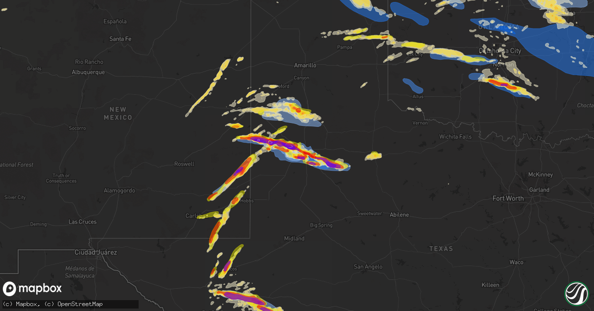
Hail Map on June 5, 2025
Get this storm
June 5 map
$229
one time, instant access
Download today. No call, no setup
Keep the $229
Bought the map and want the full workflow? Apply the entire $229 to a subscription within 7 days. None of it is wasted.
Every map, not just this one
This buys you this map. Subscription and you get every map we run, in the markets you choose from a few cities to whole states to nationwide. Plus real-time alerts the moment a storm fires.
Contact data
Name, contact info, occupancy, even credit band for addresses in the footprint. You go from where it hit to who to call.
Become the source they trust
Unlimited branding weather history reports on demand. You already have the documented answer ready for the property owner, and you are the one who showed up with it.
Property data and RoofTrace estimates
Pull up any address you have got, its value and the exact code rules for that jurisdiction, straight from One Click Code. Then RoofTrace estimates the squares, pitch, and roof value, priced the way you price.
States Impacted by Hail Map on June 5, 2025
Storm reports
New York
| Date | Description |
|---|---|
| 06/05/20256:58 PM CDT | Tree falling down on wires |
| 06/05/20256:44 PM CDT | Tree down on wires as a result of passing outflow boundary. |
| 06/05/20255:36 PM CDT | Trees and wires down |
| 06/05/20255:27 PM CDT | Wire down running across the road... Time estimated using radar. |
| 06/05/20254:25 PM CDT | Tree down on roadway near cr 129 and hayts corners east road. |
| 06/05/20254:01 PM CDT | A local report indicates 1.50 inch wind near Pulteney |
| 06/05/20254:01 PM CDT | Picture shows large hail next to measuring tape. |
| 06/05/20253:40 PM CDT | Report of wires down. |
| 06/05/20253:40 PM CDT | A local report indicates 1.50 inch wind near Benton |
| 06/05/20253:36 PM CDT | Corrects the time of the previous tstm wnd dmg report from prattsburg. Trees and wires down |
| 06/05/20253:36 PM CDT | Picture shared with us of 1.5 to 2 inch hail. |
| 06/05/20253:30 PM CDT | A local report indicates 69 MPH wind near 1 WNW Bellona Stn |
| 06/05/20253:12 PM CDT | Reports of at least one tree and multiple wires down. |
| 06/05/20251:44 PM CDT | Social media report of half to one inch hail in kennedy. |
| 06/05/20251:35 PM CDT | Delayed report. Social media report of quarter sized hail in jamestown with photo. |
| 06/04/20258:56 PM CDT | A local report indicates 1.00 inch wind near 3 NE Bovina Center |
| 06/04/20258:09 PM CDT | Tree down on road. |
| 06/04/20258:06 PM CDT | Tree down on circle dr. |
| 06/04/20257:54 PM CDT | Tree down on town line rd. |
| 06/04/20257:53 PM CDT | A local report indicates 1.00 inch wind near 1 NW Unadilla |
| 06/04/20257:48 PM CDT | Tree down on road |
| 06/04/20257:38 PM CDT | Multiple reports of trees down near w. Main street |
| 06/04/20257:23 PM CDT | Tree down blocking road |
| 06/04/20257:20 PM CDT | Tree down blocking entire roadway due to an outflow boundary |
| 06/04/20257:18 PM CDT | Tree down on hwy 41. |
Arizona
| Date | Description |
|---|---|
| 06/05/202511:50 AM CDT | Large landspout tornado reported by several people on social media... Over rural area ne of springerville. No damage reported at time of report. |
Pennsylvania
| Date | Description |
|---|---|
| 06/05/20253:53 PM CDT | Report of a tree down on north washington road in washington township. Time estimated based on radar. |
| 06/05/20253:51 PM CDT | Tree down blocking both lanes of route 321 approximately a quarter of a mile south of the intersection of bliss hill road. |
| 06/05/20253:47 PM CDT | Tree down onto a roadway on bliss hill road and gibbs hill tower road. |
| 06/05/20253:23 PM CDT | Report and photos of numerous tree branches between 1 to 3 inches in diameter snapped with the largest around 5 inches in diameter. |
| 06/05/20252:49 PM CDT | Tree down on route 62 near the intersection of red house hill road. |
| 06/05/20252:46 PM CDT | Tree down blocking the roadway on route 62. |
| 06/05/202512:51 PM CDT | Report and photo of tree snapped near the intersection of carlisle road and hilltop road. Time estimated based on radar. |
Colorado
| Date | Description |
|---|---|
| 06/05/20256:53 PM CDT | A local report indicates 60 MPH wind near 2 S Seibert |
| 06/05/20256:53 PM CDT | Hail was accumulating and about 3-4 inches deep. |
| 06/05/20256:38 PM CDT | Chaser reported accumulating ping pong ball sized hail near the intersection of county roads dd and 11. |
| 06/05/20255:23 PM CDT | A local report indicates 63 MPH wind near 1 NW Woodrow |
| 06/05/20254:39 PM CDT | A local report indicates 1.75 inch wind near 9 W Elba |
| 06/05/20253:42 PM CDT | Report from mping: quarter |
| 06/05/20253:08 PM CDT | Report from mping: quarter |
| 06/04/20258:54 PM CDT | Report via social media. |
| 06/04/20258:23 PM CDT | Mesonet station co068 040w460 u40-firstview. |
| 06/04/20258:15 PM CDT | Picture from social media. Time estimated via radar. |
| 06/04/20257:51 PM CDT | Site cr2. |
| 06/04/20257:10 PM CDT | Spotter estimated accumulating hail that ranged from penny to mostly quarters and ping pong ball in size. Hail was still falling 8 minutes after it started. Time estima |
New Mexico
| Date | Description |
|---|---|
| 06/05/20256:32 PM CDT | Corrects previous hail report from 2 ese tatum. Hail measured up to 3.5 inches in diameter. |
| 06/05/20256:32 PM CDT | Egg to tennis ball size hail reported by the public via social media. Time is estimated by radar. |
| 06/05/20256:30 PM CDT | Mesonet station 51 2sw tatum nm. |
| 06/05/20256:19 PM CDT | Report from mping: half dollar |
| 06/05/20256:12 PM CDT | Golf ball size hail reported by a trained spotter near the junction of nm 529 and us 62. |
| 06/05/20255:03 PM CDT | Location estimated. Broadcast media reports tornado on the ground between 4:03 and 4:07 pm mdt southeast of causey and near lingo. |
| 06/05/20254:55 PM CDT | Location estimated. Broadcast media reports tornado on the ground between 3:55 and 4:00 pm mdt south of causey. |
| 06/05/20254:45 PM CDT | [landspout] landspout reported by public via social media at the intersection of wipp rd and nm 128. Location of landspout is based on radar and size is approximately |
| 06/05/20254:41 PM CDT | Location estimated. Broadcast media reports tornado on the ground between 3:41 and 3:43 pm mdt sw of causey. |
| 06/05/20254:40 PM CDT | Nws employee reported tornado on the ground between 3:40 and 3:42 pm mdt 5 nw of rogers. |
| 06/05/20254:40 PM CDT | Storm chasers and broadcast media reported a tornado on the ground between 3:40 and 3:42 pm mdt 5 nnw of rogers. |
| 06/05/20254:38 PM CDT | Location estimated. South of causey. |
| 06/05/20254:37 PM CDT | Location estimated. Broadcast media reported a tornado on the ground between 3:37 and 3:38 pm mdt sw of causey. |
| 06/05/20254:35 PM CDT | Report from mping: hen egg |
| 06/05/20254:34 PM CDT | Corrects previous tornado report from 5 nw rogers. Nws employee reported tornado on the ground between 3:34 and 3:36 pm mdt 5 nw of rogers. |
| 06/05/20254:19 PM CDT | Media reports ping pong ball sized hail just south of portales. |
Ohio
| Date | Description |
|---|---|
| 06/05/20254:31 PM CDT | Reports of a power pole and lines down near the train tracks and intersection of arbor road northeast and brussel road northeast. |
| 06/05/20254:30 PM CDT | County road 51 and county road 330 in northwestern holmes county were blocked due to fallen trees and power lines. Time was estimated by radar. |
| 06/05/20253:40 PM CDT | One tree down on ridge avenue. |
| 06/05/20253:38 PM CDT | One tree down on ridge avenue. |
Kansas
| Date | Description |
|---|---|
| 06/05/20256:10 PM CDT | Report was from kake storm chaser. |
| 06/05/20255:56 PM CDT | Report from mping: ping pong ball |
| 06/05/20255:55 PM CDT | A local report indicates 1.00 inch wind near 5 W Moscow |
| 06/05/20254:49 PM CDT | Report received through slack. |
| 06/05/20254:43 PM CDT | Report via slack. |
| 06/05/20254:22 PM CDT | Corrects previous tornado report from 9 sw big bow to now 6-7 sse of johnson. Very brief tornado...no damage. Off-duty nws employee reported a tornado with a photo. Sho |
| 06/05/20254:22 PM CDT | Off-duty nws employee reported a tornado with a photo. Shortly after... Multiple storm chasers corroborated the report with more reports and pictures of the tornado. |
| 06/05/20254:09 PM CDT | Via social media. |
| 06/05/20254:05 PM CDT | Picture of golf ball sized hail on social media. |
| 06/05/20254:00 PM CDT | Picture of golf ball sized hail on social media... Time estimated of around 4:00pm. |
| 06/05/20254:00 PM CDT | Social media pictures of multiple large hail stones with one being approximately 2 inches via measuring tape. |
| 06/05/20253:51 PM CDT | Emergency manager reported 3 inch hail occurring. |
| 06/05/20253:50 PM CDT | Reported quarter size hail. |
| 06/05/20253:45 PM CDT | Via social media. |
| 06/04/20258:45 PM CDT | Corrects previous tstm wnd gst report from 3 w bloom to mesonet station instead of public. |
| 06/04/20258:45 PM CDT | Recorded wind gust from private weather station. |
| 06/04/20257:24 PM CDT | A local report indicates 1.00 inch wind near 3 E Johnson City |
Florida
| Date | Description |
|---|---|
| 06/05/20252:48 PM CDT | Delayed report...broadcast media relayed photos showing damage to the roof of a carport. Time est. Based off radar and nearest asos max wind measurement of 47mph. |
| 06/05/20252:45 PM CDT | Public reported a large tree limb broke off and fell on their roof along charlotte st near atlantic blvd. Their neighbor claims they saw weak rotation and debris lofted |
| 06/05/20251:24 PM CDT | Union county em reported a large tree fell across sr 121. Time was estimated by radar. |
Texas
| Date | Description |
|---|---|
| 06/05/20256:52 PM CDT | Nssl observes small tornado southeast of whitharral. |
| 06/05/20256:44 PM CDT | Large power poles snapped... Tree branches mangled. |
| 06/05/20256:42 PM CDT | Em reports large semi-truck rolled by tornado just south of whitharral. |
| 06/05/20256:35 PM CDT | Corrects location of previous tornado report from 5 n levelland. |
| 06/05/20256:35 PM CDT | A local report indicates a tornado near 5 N Levelland |
| 06/05/20256:15 PM CDT | Brief cone tornado reported near pettit. |
| 06/05/20256:10 PM CDT | Report from mping: baseball+ |
| 06/05/20256:04 PM CDT | Report from mping: golf ball |
| 06/05/20256:03 PM CDT | Wedge tornado observed... Then obscured by dust shortly thereafter. |
| 06/05/20255:46 PM CDT | Large wedge tornado crossing highway 214 north of morton. |
| 06/05/20255:35 PM CDT | Report from mping: tea cup |
| 06/05/20255:35 PM CDT | Swath of power poles that were snapped... Likely associated with the passage of a tornado. Damage about a half mile wide or maybe a little bit more. Time of damage is e |
| 06/05/20255:35 PM CDT | Observed by the icechip project. |
| 06/05/20255:35 PM CDT | Multiple reports of a large wedge tornado ongoing northwest of morton. |
| 06/05/20255:33 PM CDT | Observed by the icechip project. |
| 06/05/20255:31 PM CDT | A local report indicates a tornado near 7 WNW Morton |
| 06/05/20255:14 PM CDT | Several brief tornado touchdowns reported just to the east of the state line. |
| 06/05/20254:48 PM CDT | Hen egg size hail partially shattering the windshield of a vehicle. Time is estimated by radar. |
| 06/05/20254:42 PM CDT | Ping pong to golf ball size hail reported by public via social media. Time is estimated by radar. |
| 06/05/20254:27 PM CDT | A local report indicates 2.50 inch wind near 8 S Fort Stockton |
| 06/05/20254:07 PM CDT | Hen egg size hail reported by emergency manager. Time is estimated by radar. |
| 06/05/20253:57 PM CDT | Corrects previous location of mesonet. |
| 06/05/20253:57 PM CDT | Thunderstorm wind gust recorded by west texas mesonet station. |
| 06/05/20253:20 AM CDT | A local report indicates 60 MPH wind near 5 WSW Matador |
| 06/05/20252:15 AM CDT | A dry microburst under a decaying thunderstorm anvil caused these winds. Awos station ke41 big lake. |
| 06/05/20252:15 AM CDT | Mesonet station 79 3wsw aiken. |
| 06/05/20252:13 AM CDT | Mesonet station 79 3wsw aiken. |
| 06/05/20252:08 AM CDT | A dry microburst under a decaying thunderstorm anvil caused these winds. Mesonet station 64 big lake. |
| 06/05/20252:07 AM CDT | Also gusted to 59 mph at 208 am. Mesonet station 3 plainview 1s. |
| 06/05/20252:03 AM CDT | Mesonet station 95 vigo park. |
| 06/05/20251:00 AM CDT | Lipscomb 8w wt mesonet measured 68 mph wind gusts from collapsing thunderstorm. |
| 06/05/202512:19 AM CDT | A local report indicates 64 MPH wind near 2 NE Dimmitt |
| 06/04/202511:10 PM CDT | Wind-driven hail busted out windows at cr 7120 east of ransom canyon. Additional damage occurred about 1 mile north of the location. No hail size or wind magnitude was |
| 06/04/202511:09 PM CDT | Report from mping: hen egg+ |
| 06/04/202510:30 PM CDT | Report from mping: tennis ball |
| 06/04/202510:22 PM CDT | Report from mping: golf ball |
| 06/04/202510:15 PM CDT | A local report indicates 1.00 inch wind near Shallowater |
| 06/04/20259:51 PM CDT | Awos station k6r6 5 w dryden. |
| 06/04/20259:30 PM CDT | Roof of west carlisle fire station is gone over the meeting room. |
| 06/04/20259:07 PM CDT | Fences knocked down and roofs removed from homes at 19th near milwaukee. |
| 06/04/20258:50 PM CDT | A local report indicates 2.50 inch wind near 3 E Wolfforth |
| 06/04/20258:49 PM CDT | A local report indicates 1.50 inch wind near 4 SSE Lubbock |
| 06/04/20258:48 PM CDT | Shed and fence blown down on west side of lubbock near 34th and milwaukee. |
| 06/04/20258:47 PM CDT | Social media. |
| 06/04/20258:44 PM CDT | Powerlines down. |
| 06/04/20258:42 PM CDT | Severe gusts measured from 839 pm through 848 pm. |
| 06/04/20258:36 PM CDT | Large tree branches across the parking lot at the hotel. |
| 06/04/20258:35 PM CDT | Power line down in the area of 58th street and temple. |
| 06/04/20258:30 PM CDT | Report from mping: quarter |
| 06/04/20258:28 PM CDT | A local report indicates 2.00 inch wind near 4 SSE Lubbock |
| 06/04/20258:28 PM CDT | Report from mping: half dollar |
| 06/04/20258:25 PM CDT | Report from mping: hen egg |
| 06/04/20258:25 PM CDT | Windows blown out by hail. |
| 06/04/20258:24 PM CDT | Tree branches blown down. |
| 06/04/20258:24 PM CDT | A local report indicates 1.00 inch wind near 3 SSW Lubbock |
| 06/04/20258:21 PM CDT | A local report indicates 2.50 inch wind near 4 NNW Woodrow |
| 06/04/20258:20 PM CDT | A local report indicates 58 MPH wind near 6 S Wolfforth |
| 06/04/20258:20 PM CDT | Windows and skylight broken by hail. |
| 06/04/20258:20 PM CDT | Quarter size hail at nws lubbock office. |
| 06/04/20258:19 PM CDT | Measured at 103rd street and winston avenue in southwest lubbock. Most of the roofs are totaled from the wind-driven hail. |
| 06/04/20258:19 PM CDT | Measured at nws lubbock office. |
| 06/04/20258:18 PM CDT | Extensive shredding of trees/leaves/plants from wind-driven hail. Cracked windows and downed tree branches. Shredded leaves were noted from 98th st. At frankford avenue |
| 06/04/20258:16 PM CDT | All north-facing windows broken out of apartment complex at 98th street & upland avenue by wind-driven hail in southwest lubbock. Time of damage is estimated. |
| 06/04/20258:16 PM CDT | Roof blown off of old service station. |
| 06/04/20258:16 PM CDT | Severe gusts measured from 815 pm to 816 pm. |
| 06/04/20258:15 PM CDT | Report from mping: tennis ball |
| 06/04/20258:15 PM CDT | Significant damage from wind-driven hail at milwaukee avenue and 73rd street in southwest lubbock. Nearly 20 apartment windows shattered and some car windshields cracke |
| 06/04/20258:13 PM CDT | Report from mping: golf ball |
| 06/04/20258:12 PM CDT | Report from mping: golf ball |
| 06/04/20258:11 PM CDT | A local report indicates 1.75 inch wind near 1 SSW Wolfforth |
| 06/04/20258:11 PM CDT | Report from mping: half dollar |
| 06/04/20258:10 PM CDT | A local report indicates 1.00 inch wind near 3 ENE Wolfforth |
| 06/04/20258:10 PM CDT | Carport flipped over at hunters way apartments near 56th street and southwest loop 289 in lubbock. Time of damage estimated. |
| 06/04/20258:08 PM CDT | A local report indicates 1.25 inch wind near 4 ESE Reese Center |
| 06/04/20258:07 PM CDT | Severe gusts up to 80 mph measured from 752 pm until 815 pm. |
| 06/04/20258:05 PM CDT | Severe gusts from up to 66 mph measured from 805 pm to 820 pm. |
| 06/04/20258:04 PM CDT | Debris from different industrial structures in the milwaukee ridge community... Including metal sheets. Also minor tree damage. Exact location and time of damage estima |
| 06/04/20258:03 PM CDT | 3 oak trees... 6 inch diameter... Snapped; 20 ft length of 6 ft high fence blown over at 30th street and milwaukee avenue on the west side of lubbock. Time of damage es |
| 06/04/20258:02 PM CDT | Large oak tree... Roughly 2 ft diameter... Split down middle. About 20-30 branches down on street. Tree branches fell/bent metal fence on 30th street and oakridge avenu |
| 06/04/20258:02 PM CDT | Mobile homes rolled and roof lifted off of single family home. |
| 06/04/20258:00 PM CDT | Railroad crossing guard damaged at 4th street and inter ave just east of reese center. Additional damage in the nearby area included a greenhouse roof that was destroye |
| 06/04/20258:00 PM CDT | A house lost bricks and shingles... As well as the fence on the southeast side of home... At 12th street & inler avenue. The time of the damage is estimated. |
| 06/04/20257:55 PM CDT | Roofs removed from buildings... Sheds rolled... At 179 and 19th. |
| 06/04/20257:53 PM CDT | Peak measured gust. |
| 06/04/20257:50 PM CDT | Large carport ripped loose from house and entangled in power lines. |
| 06/04/20257:50 PM CDT | Rain-wrapped tornado observed. |
| 06/04/20257:50 PM CDT | Also gusted to 58 mph at 742 pm. |
| 06/04/20257:46 PM CDT | Peak gust of 109 mph. Gust of 107 mph also measured at 747 pm. |
| 06/04/20257:46 PM CDT | Peak gust of 109 mph. Gust of 107 mph also observed at 747 pm. |
| 06/04/20257:41 PM CDT | *** 1 inj *** em reports structure damage from tornado. |
| 06/04/20257:41 PM CDT | *** 1 inj *** em reports structure damage from tornado. |
| 06/04/20257:41 PM CDT | Gusts ranging from 61 mph to 69 mph measured from 737 pm to 742 pm. |
| 06/04/20257:40 PM CDT | Gusts ranging from 63 to 95 mph observed from 738 pm to 745 pm. |
| 06/04/20257:38 PM CDT | Mesonet station ur285 4.4 e marathon |
| 06/04/20257:32 PM CDT | Twin tornadoes observed by nssl. |
| 06/04/20257:27 PM CDT | Power poles snapped. |
| 06/04/20257:24 PM CDT | Video of multi-vortex tornado just west of reese center. |
| 06/04/20257:14 PM CDT | A local report indicates a tornado near 6 NE Smyer |
| 06/04/20257:05 PM CDT | Social media photo shows giant hailstone recovered about 40 minutes after falling... Still about 5 inches in diameter even with some melting. Time estimated from radar. |
| 06/04/20257:05 PM CDT | Social media photo shows giant hailstone recovered about 40 minutes after falling... Still about 5 inches in diameter even after melting. Time estimated from radar. |
Massachusetts
| Date | Description |
|---|---|
| 06/05/20256:20 AM CDT | In devens... A mesonet station gusted to 72 mph. |
| 06/05/20256:15 AM CDT | In ayer there were trees down blocking the road on elm street. |
| 06/05/20256:15 AM CDT | In shirley... A large tree was down on patterson rd. Relayed by amateur radio. |
| 06/05/20256:15 AM CDT | In shirley... Broadcast media sent aerial photos of around a dozen trees uprooted or snapped off at the top laying in the same direction on walker rd. |
| 06/05/20256:15 AM CDT | In shirley... A trained spotter reported quarter size hail. Report was relayed via amateur radio. |
| 06/05/20256:11 AM CDT | In ayer... A tree was down on sandy pond rd. |
| 06/05/20255:41 AM CDT | Asos station kfit fitchburg ap. |
| 06/05/20255:41 AM CDT | The fitchburg airport asos |
Oklahoma
| Date | Description |
|---|---|
| 06/05/20256:12 PM CDT | Sign... Fence and tree damage. Several semi-trucks blown over. Time estimated from radar. |
| 06/05/20256:05 PM CDT | A local report indicates 70 MPH wind near 3 W Paoli |
| 06/05/20256:00 PM CDT | Large tree down. Time estimated from radar. |
| 06/05/20255:56 PM CDT | Power line down. Time estimated from radar. |
| 06/05/20255:38 PM CDT | Large trees down... Carport destroyed. Time estimated from radar. |
| 06/05/20255:15 PM CDT | Mesonet station chic chickasha. |
| 06/05/20254:47 PM CDT | A local report indicates 60 MPH wind near 2 NNW Newcastle |
| 06/05/20254:47 PM CDT | A local report indicates 60 MPH wind near 2 NNW Newcastle |
| 06/05/20254:25 PM CDT | A local report indicates 1.00 inch wind near 4 E Minco |
| 06/05/20253:41 PM CDT | Large trees down... Roof damage and barn destroyed. |
| 06/05/202511:52 AM CDT | A local report indicates 1.50 inch wind near Hardesty |
| 06/05/20256:55 AM CDT | Storm chaser reported tornado crossing i-40 and radar data showed a debris signature. |
| 06/05/20256:55 AM CDT | Measured thunderstorm wind gust of 67 mph at the stigler mesonet. |
| 06/05/20256:30 AM CDT | Power lin |
| 06/05/20256:30 AM CDT | Power lines down. |
| 06/05/20256:27 AM CDT | Roof and other sheet metal sections of pole barn blown off. Additional tree damage cause |
| 06/05/20256:27 AM CDT | Roof and other sheet metal sections of pole barn blown off. Additional tree dam |
| 06/05/20256:27 AM CDT | Roof and other sheet metal sections of pole barn blown off. Additional tree d |
| 06/05/20256:27 AM CDT | Roof and other sheet metal sections of pole barn blown off. Additional tree damage c |
| 06/05/20256:27 AM CDT | Roof and other sheet metal sections of pole barn blown off. Additional tree damage caused from thunderstorm winds. |
| 06/05/20256:05 AM CDT | Large barn destroyed. Large tree downed. Extensive tree damage. Time estimated. Possible tornado. |
| 06/05/20255:20 AM CDT | Video of tornado at this location by media. |
| 06/05/20255:07 AM CDT | A local report indicates 60 MPH wind near 4 WSW Oologah |
| 06/05/20254:55 AM CDT | Corrects previous tstm wnd gst report from 4 wsw oologah. |
| 06/05/20254:43 AM CDT | Tree damage in the wellston area. Time estimated by radar. |
| 06/05/20254:20 AM CDT | A local report indicates 77 MPH wind near 2 SSE Guthrie |
| 06/05/20254:09 AM CDT | A local report indicates 60 MPH wind near 2 S Wynona |
| 06/05/20254:05 AM CDT | Heat burst. |
| 06/05/20253:54 AM CDT | Power pole blown down. |
| 06/05/20253:03 AM CDT | Public weather station. |
| 06/05/20252:58 AM CDT | Asos station kpnc ponca city. |
| 06/05/20252:54 AM CDT | Asos station kpnc ponca city. |
| 06/05/20252:50 AM CDT | A local report indicates 60 MPH wind near 5 SW Orienta |
| 06/05/20252:45 AM CDT | A local report indicates 1.00 inch wind near Enid |
| 06/05/20252:43 AM CDT | Report from mping: half dollar |
| 06/05/20252:35 AM CDT | Awos station kbkn blackwell. |
| 06/05/20251:37 AM CDT | Asos station kgag gage. |
| 06/04/202511:52 PM CDT | Corrects previous hail report from hardesty. |
| 06/04/202511:29 PM CDT | A local report indicates 1.00 inch wind near 7 E Hough |
Utah
| Date | Description |
|---|---|
| 06/04/20258:10 PM CDT | Picture on social media of broken 1 inch diameter tree branches in bloomington. |
| 06/04/20258:10 PM CDT | Broken 1 inch diameter tree branches reported via mping. |
Nevada
| Date | Description |
|---|---|
| 06/05/20254:25 PM CDT | A local report indicates 1.00 inch wind near 3 WSW North Las Vegas A |
| 06/05/20254:24 PM CDT | A local report indicates 1.00 inch wind near 3 NE Summerlin |
Maine
| Date | Description |
|---|---|
| 06/05/20256:01 PM CDT | Trees down near the intersection of framingham and carson roads. |
| 06/05/20255:59 PM CDT | Trees and wires down at 1432 foxcroft rd in littleton. |
| 06/05/20255:55 PM CDT | Tree down across shaw rd in littleton. |
| 06/05/20255:54 PM CDT | Trees down across us route 1 blocking traffic. |
| 06/05/20255:51 PM CDT | Tree down across ross ridge rd in littleton. |
| 06/05/20255:47 PM CDT | Tree down across wires at 341 station rd in littleton. |
| 06/05/20255:35 PM CDT | Tree down along east blaine road. |
| 06/05/20255:22 PM CDT | Single dead tree fell near where us route 2 intersects i95. |
| 06/05/20255:22 PM CDT | Trees down on rt 212 near clark rd. |
| 06/05/20255:17 PM CDT | Trees down just south of knowles corner. |
Cities Impacted by Hail Map on June 5, 2025
- Hereford, TX
- Canyon, TX
- Wildorado, TX
- Amarillo, TX
- Claude, TX
- Tulia, TX
- Happy, TX
- Dimmitt, TX
- Nazareth, TX
- Silverton, TX
- Graham, TX
- Pampa, TX
- Miami, TX
- Canadian, TX
- Stinnett, TX
- Borger, TX
- Briscoe, TX
- Reydon, OK
- Hedley, TX
- Farmington, NM
- Cheyenne, OK
- Jamestown, NY
- Falconer, NY
- Frewsburg, NY
- Hammon, OK
- Elk City, OK
- Kennedy, NY
- Texola, OK
- Balmorhea, TX
- Butler, OK
- Holly, CO
- Fort Davis, TX
- Sweetwater, OK
- Wheeler, TX
- Shamrock, TX
- Durham, OK
- Walsh, CO
- Two Buttes, CO
- Covington, TN
- Granada, CO
- Colorado Springs, CO
- Syracuse, KS
- Clinton, OK
- Canute, OK
- Sayre, OK
- Erick, OK
- Fort Stockton, TX
- Pecos, TX
- Glouster, OH
- Arapaho, OK
- Burlison, TN
- Foss, OK
- Corn, OK
- Manter, KS
- Weldona, CO
- Fort Morgan, CO
- Weatherford, OK
- Carter, OK
- Cohocton, NY
- Rushville, NY
- Stanley, NY
- Geneva, NY
- Penn Yan, NY
- Middlesex, NY
- Hydro, OK
- Colony, OK
- Prattsburgh, NY
- Beach City, OH
- Navarre, OH
- Bath, NY
- Avoca, NY
- Log Lane Village, CO
- Bellona, NY
- Lookeba, OK
- Binger, OK
- Hammondsport, NY
- Searchlight, NV
- Wayland, NY
- Atlanta, NY
- Johnson, KS
- Canton, OH
- East Sparta, OH
- Stanton, TN
- Hinton, OK
- Romulus, NY
- Ovid, NY
- Dresden, NY
- Pulteney, NY
- Branchport, NY
- Keuka Park, NY
- Elida, NM
- Pep, NM
- Portales, NM
- Floyd, NM
- Brush, CO
- Gracemont, OK
- Anadarko, OK
- Minco, OK
- Woodrow, CO
- Naples, NY
- Rogers, NM
- Dundee, NY
- Las Vegas, NV
- Rock Stream, NY
- Burdett, NY
- Canon City, CO
- Mentone, TX
- Hornell, NY
- Akron, CO
- Tuttle, OK
- Woodland, MS
- Aurora, NY
- King Ferry, NY
- Hector, NY
- Carlsbad, NM
- Ulysses, KS
- Maple, TX
- Causey, NM
- Loving, NM
- Newcastle, OK
- Blanchard, OK
- Savona, NY
- Coyanosa, TX
- Lindon, CO
- Morton, TX
- Sudan, TX
- Anton, CO
- Enochs, TX
- Branson, CO
- Moscow, KS
- Kim, CO
- Ninnekah, OK
- Chickasha, OK
- Bradford, NY
- Fort Sumner, NM
- Pyote, TX
- Barstow, TX
- Hugoton, KS
- Verden, OK
- Trumansburg, NY
- Ithaca, NY
- Jal, NM
- Overton, NV
- Artesia, NM
- Alex, OK
- Bradley, OK
- Lindsay, OK
- Interlaken, NY
- Melrose, NM
- Beaver Dams, NY
- Watkins Glen, NY
- Amber, OK
- Satanta, KS
- Cope, CO
- Arriba, CO
- Maljamar, NM
- Imperial, TX
- Muleshoe, TX
- Cement, OK
- Pep, TX
- Littlefield, TX
- Amherst, TX
- Taiban, NM
- House, NM
- Maysville, OK
- Purcell, OK
- Wink, TX
- Kermit, TX
- Springfield, CO
- Hobbs, NM
- Yellville, AR
- Lovington, NM
- Wayne, OK
- Pauls Valley, OK
- Paoli, OK
- Flagler, CO
- Freeville, NY
- Cannon Afb, NM
- Clovis, NM
- Mcalister, NM
- Houlton, ME
- Summit, AR
- Wynnewood, OK
- Levelland, TX
- Texico, NM
- Mcdonald, NM
- Tatum, NM
- Westfield, PA
- Tucumcari, NM
- Dryden, NY
- Stratford, OK
- Davis, OK
- Marathon, TX
- Seibert, CO
- Farwell, TX
- Marathon, NY
- Cincinnatus, NY
- Wellsboro, PA
- Gaines, PA
- Whitney Point, NY
- Alpine, TX
- Sublette, KS
- Willet, NY
- Smithville Flats, NY
- Anton, TX
- Vona, CO
- Ada, OK
- Sulphur, OK
- Roff, OK
- Greene, NY
- Shallowater, TX
- San Jon, NM
- Friona, TX
- McDonough, NY
- Mountain Home, AR
- Norfork, AR
- Oxford, NY
- Copeland, KS
- Plains, KS
- Lubbock, TX
- Chenango Forks, NY
- Bainbridge, NY
- Stratton, CO
- Fitzhugh, OK
- Stonewall, OK
- Mount Upton, NY
- Kit Carson, CO
- Montezuma, KS
- Meade, KS
- Guilford, NY
- Afton, NY
- Unadilla, NY
- Elkhart, KS
- Chester, OK
- La Junta, CO
- Seiling, OK
- Cheyenne Wells, CO
- Franklin, NY
- Sidney, NY
- Richfield, KS
- Ropesville, TX
- Wells Bridge, NY
- Wolfforth, TX
- Haswell, CO
- Eads, CO
- Otego, NY
- Sidney Center, NY
- Smyer, TX
- Whiteface, TX
- Slaton, TX
- Ransom Canyon, TX
- Idalou, TX
- Cleo Springs, OK
- Aline, OK
- Las Animas, CO
- Carmen, OK
- Delhi, NY
- Walton, NY
- Waynoka, OK
- Helena, OK
- Pritchett, CO
- Dacoma, OK
- Lorenzo, TX
- Fairview, OK
- Minneola, KS
- Crosbyton, TX
- Spur, TX
- Dryden, TX
- Sheridan Lake, CO
- Fieldton, TX
- Wilson, TX
- Norwich, NY
- Goltry, OK
- Jet, OK
- Cherokee, OK
- Nash, OK
- Ford, KS
- Oneonta, NY
- Ralls, TX
- Post, TX
- Baker, CA
- Bucklin, KS
- Justiceburg, TX
- Mullinville, KS
- Rolla, KS
- Campo, CO
- Vilas, CO
- Meno, OK
- Ringwood, OK
- Snyder, TX
- Lahoma, OK
- Enid, OK
- Carrier, OK
- Earth, TX
- Bovina, TX
- Waldron, KS
- Goodwell, OK
- Guymon, OK
- Jean, NV
- Felt, OK
- Dalhart, TX
- Paducah, TX
- Hooker, OK
- Turpin, OK
- Bovina Center, NY
- Englewood, KS
- Gate, OK
- Hardesty, OK
- Forgan, OK
- Beaver, OK
- Freedom, OK
- Balko, OK
- Perryton, TX
- Rosston, OK
- Ashland, KS
- Buffalo, OK
- Alva, OK
- Amorita, OK
- Booker, TX
- Hart, TX
- Springlake, TX
- Olton, TX
- Plainview, TX
- Kress, TX
- Mooreland, OK
- Wakita, OK
- Bluff City, KS
- Braman, OK
- Burlington, OK
- Manchester, OK
- Newkirk, OK
- Medford, OK
- Lipscomb, TX
- Higgins, TX
- Spearman, TX
- Arnett, OK
- Arkansas City, KS
- Sharon, OK
- Deer Creek, OK
- Blackwell, OK
- Hale Center, TX
- Shattuck, OK
- Gage, OK
- Fargo, OK
- Nardin, OK
- Lamont, OK
- Lockney, TX
- Vici, OK
- Camargo, OK
- Leedey, OK
- Taloga, OK
- Maple City, KS
- Hunter, OK
- Tonkawa, OK
- Kremlin, OK
- Pond Creek, OK
- Ponca City, OK
- Dexter, KS
- Red Rock, OK
- Billings, OK
- Shidler, OK
- Marland, OK
- Rolla, MO
- Bartlesville, OK
- Pawhuska, OK
- Pawnee, OK
- Ralston, OK
- Fairfax, OK
- Garber, OK
- Fairmont, OK
- Bison, OK
- Waukomis, OK
- Covington, OK
- Burbank, OK
- Wynona, OK
- Hominy, OK
- Isabella, OK
- Ames, OK
- Kingfisher, OK
- Loyal, OK
- Dover, OK
- Okarche, OK
- Omega, OK
- Hennessey, OK
- Cleveland, OK
- Crescent, OK
- Cashion, OK
- Guthrie, OK
- Osage, OK
- Maramec, OK
- Prue, OK
- Skiatook, OK
- Barnsdall, OK
- Sand Springs, OK
- Mulhall, OK
- Jennings, OK
- Coyle, OK
- Meridian, OK
- Wellston, OK
- Luther, OK
- Lucien, OK
- Vinita, OK
- Welch, OK
- Bluejacket, OK
- Delaware, OK
- Piedmont, OK
- Mannford, OK
- Terlton, OK
- Sperry, OK
- Tulsa, OK
- Collinsville, OK
- Owasso, OK
- Ramona, OK
- Vera, OK
- Talala, OK
- Oologah, OK
- Oklahoma City, OK
- Union City, OK
- Agra, OK
- Carney, OK
- Tryon, OK
- Mustang, OK
- Edmond, OK
- El Reno, OK
- Jones, OK
- Yukon, OK
- Arcadia, OK
- Drumright, OK
- Claremore, OK
- Catoosa, OK
- Kellyville, OK
- Sapulpa, OK
- Bristow, OK
- Norman, OK
- Park Hills, MO
- Mounds, OK
- Glenpool, OK
- Kiefer, OK
- Noble, OK
- Newalla, OK
- Jenks, OK
- Bixby, OK
- Fitchburg, MA
- Broken Arrow, OK
- Lexington, OK
- Boley, OK
- Paden, OK
- Castle, OK
- Eldorado, OK
- Chillicothe, TX
- Leominster, MA
- Wanette, OK
- Vernon, TX
- Macomb, OK
- Lunenburg, MA
- Haskell, OK
- Okemah, OK
- Byars, OK
- Morris, OK
- Okmulgee, OK
- Locust Grove, OK
- Peggs, OK
- Boynton, OK
- Shirley, MA
- Ayer, MA
- Devens, MA
- Lancaster, MA
- Asher, OK
- Council Hill, OK
- Harvard, MA
- Littleton, MA
- Groton, MA
- Muskogee, OK
- Taft, OK
- Oktaha, OK
- Eufaula, OK
- Checotah, OK
- Vian, OK
- Gore, OK
- North Las Vegas, NV
- Sterling, MA
- Canadian, OK
- Mcalester, OK
- Beggs, OK
- Porter, OK
- Weleetka, OK
- Henryetta, OK
- Stigler, OK
- Webbers Falls, OK
- Porum, OK
- Whitefield, OK
- Kinta, OK
- Red Oak, OK
- Keota, OK
- Bokoshe, OK
- Mccurtain, OK
- Wister, OK
- Wilburton, OK
- Quinton, OK
- Warner, OK
- Hanna, OK
- Indianola, OK
- Crowder, OK
- Dustin, OK
- Lamar, OK
- Holdenville, OK
- Wewoka, OK
- Wetumka, OK
- Seminole, OK
- Earlsboro, OK
- Shawnee, OK
- Prague, OK
- Meeker, OK
- Chandler, OK
- Sparks, OK
- Stroud, OK
- Davenport, OK
- Perkins, OK
- Cushing, OK
- Depew, OK
- Shady Point, OK
- Sallisaw, OK
- Braggs, OK
- Pocasset, OK
- Cordell, OK
- Mangum, OK
- Willow, OK
- Granite, OK
- Blair, OK
- Altus, OK
- Bessie, OK
- New Deal, TX
- Arapahoe, CO
- Fowler, KS
- Protection, KS
- Coldwater, KS
- Wilmore, KS
- Haviland, KS
- Girard, TX
- Tahoka, TX